A combination of the Trans Canada (TCT)/Cowichan Valley Trail and a side trail to a spectacular sequence of falls, each with its own character.
LOCATION
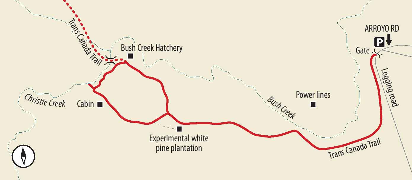
On the northern outskirts of Ladysmith at a significant exit, turn onto Grouhel Road. Drive 200 m and turn right onto Christie Road for 1.7 km. Turn left onto Arroyo Road and drive a short distance to a gate where there is a barrage of dire warning signs about the logging roads ahead. Fear not. The trailhead from the logging road, where most visitors park, is about 150 m ahead at another gate on the right. Since, however, signs warn that the first gate may be locked at any time, you might feel most comfortable parking alongside the road outside this gate and hoofing it the short stretch to the TCT branch.
DISTANCE
6.8 km
ELEVATION GAIN
125 m
DIFFICULTY
Most of the route is along a deactivated logging road now designated as part of the TCT. The trail along Christie Creek to the falls is a narrow dirt track that climbs steadily over rocks and roots, but it requires nothing more than a little sure-footedness and a healthy pair of lungs. There is a narrow, single-log bridge on which you can view one set of falls, but this is an optional extra, not recommended for most children.
SEASON
All season, but obviously the wet season produces the most splash and dash in falls that can dwindle to very little after a long hot summer.
OF SPECIAL INTEREST FOR CHILDREN
As with so many waterfall trails, this one leads to a highlight that most kids should find exciting, not least of all because there are several different chunks of the many-stepped falls to explore – and many accessible viewpoints from which to see them.
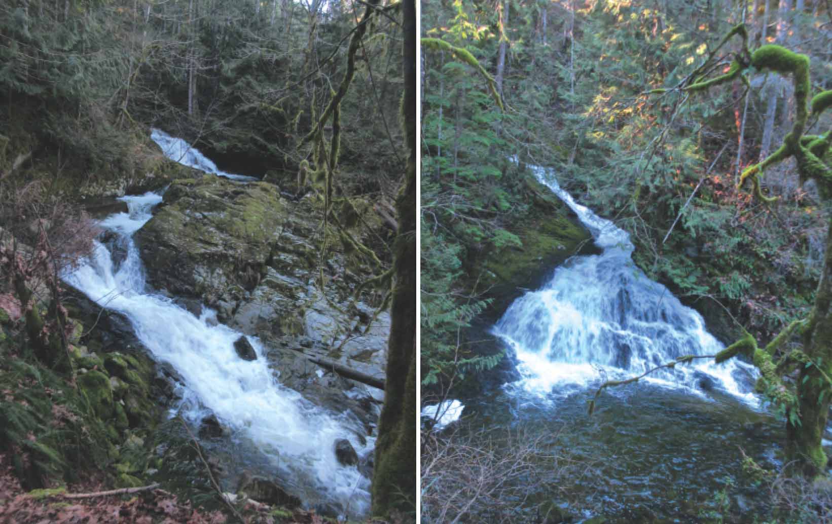
FROM LEFT Interesting double falls converging into a single chute; the uppermost falls drop in a bridal-veil spray.
1.If you have parked outside the first gate by the battery of threatening signs, walk to the Trans Canada Trail sign and the red/ orange gate on the right. Pass the gate and continue your traverse up the side of a valley, crossing a culvert and passing under power lines. As you enter a grove of larger trees, you begin probably the most attractive part of the walk up the valley. Here you have something of the impression of being partway to the canopy of the comparatively big hemlock, fir and cedar above a bed of sword ferns far below. For awhile you can hear the rush of the creek below you, but you soon leave it behind.
2.As you approach a stand of dense, uniform pine on your left, keep an eye open for a small track. It is worthwhile taking the few steps up this track where you see a sign explaining a research project involving the attempts to develop disease-resistant white pine. Back on the TCT, you soon see a left fork in the road with a sign indicating that the hatchery is on the larger roadway straight ahead. Note the spot because you return from the falls along the smaller road on the left.
3.The forest opens a little as you pass through smaller trees, and, before long, you arrive at a large, solid building and a sign about the Bush Creek Hatchery. Another sign gives an aerial-photo view of Christie Falls and the trails. In case you have trouble interpreting this map, note that you have been walking along the broad, green trail to this point, but now will be leaving it to turn left onto the smaller orange trail.
4.Begin the watery part of your tour by making a short detour to the middle of the bridge along the TCT. Return to cross the large open area to admire the first bits of cascade (and possibly take advantage of the outhouse). Start up the signed narrow dirt trail heading up through the trees to the left of the stream. Upstream, pass one particularly grand old fir and some reasonably secure viewpoints over a lovely, fan-shaped cascade.
5.The climax of the falls, though, is a zigzagging sequence of multiple falls cutting around a kind of island. With a family, you are best off appreciating the good views from this side of the creek. At the top of this sequence is a side trail to probably the most impressive falls, shooting out from a crest of rock high above you. However, there is a narrow log bridge (with reasonably good grip and a rope support) to the island and a view of another good bit of waterfall. Don’t feel, however, you’re missing out on the best by staying high and dry! You’re not.
6.Continue on the signposted trail as it climbs away from the creek, passing a self-consciously cute log cabin, and begin the descent to complete the loop. One short section at the bottom of the descent can be very wet in winter, but thereafter the trail becomes an old roadbed. This curves gradually left (ignore a slightly smaller track to the right) before bringing you back to the junction with the outward route.