A series of loop trails along a forested river remarkable for its deep, largely still pools, by small gravel beaches or sculpted rock bluffs. This trail runs through Chemainus River Provincial Park, but as is the case with many provincial parks, this one is undeveloped.
LOCATION
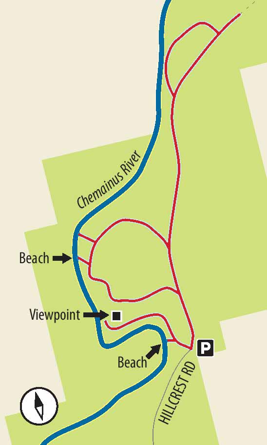
On Highway 1, between Chemainus and Duncan, at the traffic lights, turn onto Highway 18 signposted for Cowichan Lake. At just under 7 km, turn right onto Hillcrest Road (a gravel logging road). After 6 km, come to a small gravel parking area on the right, with a bit of a concrete barrier and a sign on a tree forbidding the use of motorized vehicles on the trails.
DISTANCE
3-km series of loops
ELEVATION GAIN 20 m, cumulative, over an essentially flat area with trails down to and up from the riverbank.
DIFFICULTY
Easy, broad trails (many ATV tracks).
SEASON
Year-round, but swimmers clearly will zero in on summer.
OF SPECIAL INTEREST FOR CHILDREN
Splashing, wading, swimming, cavorting…the appeal of the park is obvious.
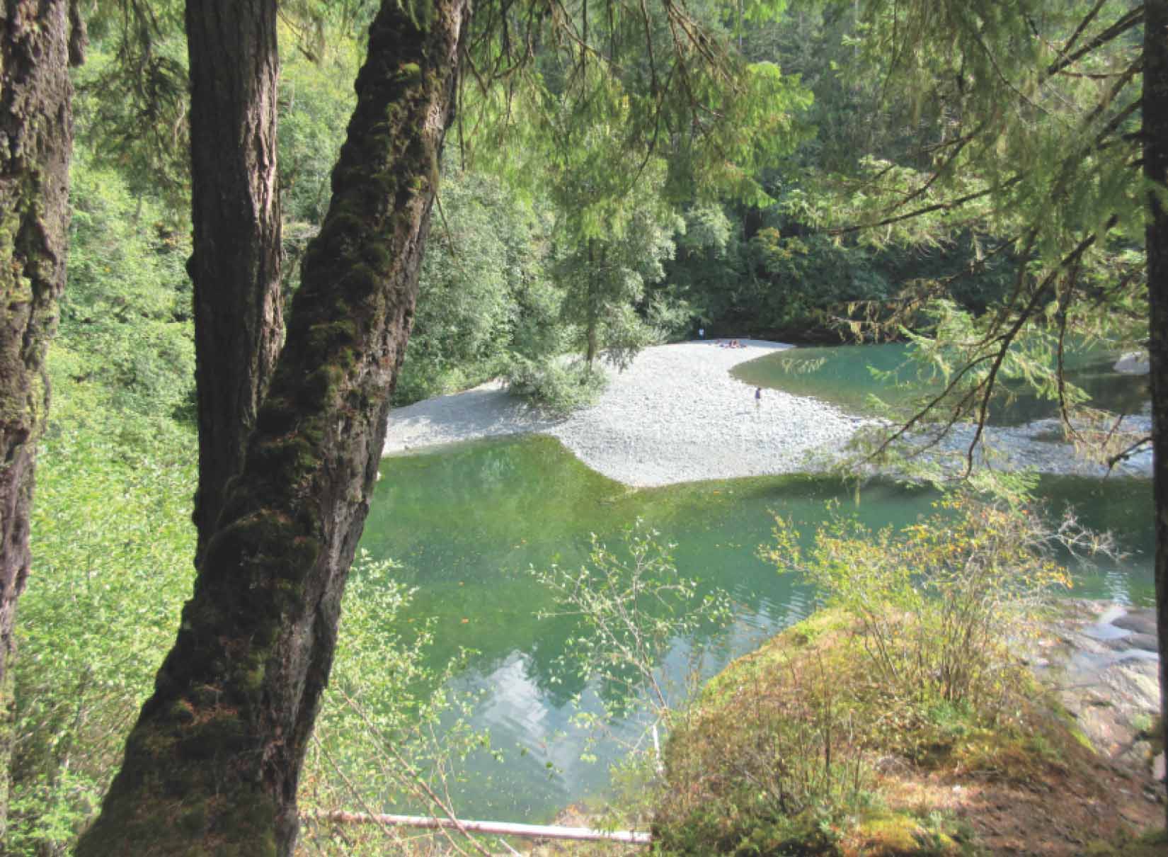
FROM ABOVE A beautiful large cedar overhangs a deep pool downstream from the park entrance; the view into the deep pool from the bluffs.

1.The first of the four down-and-up trails to the river is by far the shortest, and the prettiest. Simply cross the dirt road and walk a short distance until you see a broad (ATV-width) track leading down the slope and onto a gravel bar. At a sharp S curve in the Chemainus River, a gravel bar serves as a great beach with easy access to deep, jade-green pools of luscious, clear water. Last one in…!
2.Returning up the slope, come to a bare area under firs. Keep to the left, roughly parallel to the curve in the river, and take another broad track down towards the river. En route, have a fine bank-top view of the beach you just left and be treated to a chainsaw carving that makes up in fun what it may lack in subtle skill. This dead-end track leads down behind a log jam and only awkward access to the river.
3.Back at the top of the slope, turn left along the gravel logging road. After a few minutes, notice a sign high on a fir to the left of the road, announcing this to be Chemainus River Park and telling you what you mustn’t do. Here you see the beginning of the third approach to the river, another broad track curving in a large loop through salal and under firs.
4.A steady tromp will bring you to the level of the river, and a short side track to the river with a small rocky beach overhung by a grand old maple. Return the short distance on this loop route, and a short walk later take the next side trail to the riverside. Here you find a short, fairly steep drop by a large cedar to view a gravel bar and a very wee set of pro-to-rapids. Return to the loop track to make your way back up a substantial slope towards the gravel road.
5.To reach the last loop off the gravel road, you need to undertake a substantial trek of several hundred metres. Pass a yellow sign saying “3 Km UP” (don’t worry – this makes sense to logging vehicles). Just a few metres afterwards, take the fork to the left and almost immediately see the riverbank ahead at the bottom of the slope. This is probably not the spot you want to seek out if you have getting wet on your agenda. The track stops in a clearing at the top of a steep little bank. Though there are trails down this bank, they do lead to a large boulder floodplain, with the river itself still a good distance away.

The favoured swimming spot near the first access to the river.
6.Carry on past this viewpoint to complete the loop by climbing a steep little slope back up to the gravel road. If you really are determined to get some exercise and do a little exploring, you can turn left and go farther along this logging road, since, for the most part, it is free of traffic. The accessible part of the river exploration is complete, however, so most intrepid hikers will simply want to stroll along the road back to the patiently waiting car.