Clear trails and deep, emerald-green pools beneath sculpted rock formations – and connections to long-distance trails (including Kinsol Trestle). Like many provincial parks, Koksilah has scant evidence of maintenance or development.
LOCATION
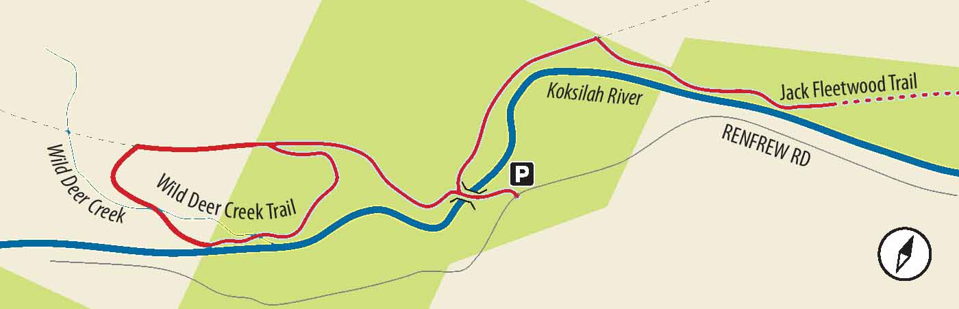
From Highway 1 in Mill Bay, turn at the traffic lights away from the water onto Shawnigan Lake/Mill Bay Road. When you get to the T junction by Shawnigan Lake, turn right at the end of the lake, then left onto Renfrew Road. Follow Renfrew Road past Shawnigan Lake, which continues after the road becomes gravel. Koksilah Provincial Park is signposted on a carved wooden sign, but don’t expect any park amenities other than a well-used but slightly chaotic dirt parking area.
DISTANCE
2.3-km return (plus 1.6-km return optional add-on)
ELEVATION GAIN
30 m
DIFFICULTY
No steep grades or exposed positions, but trails can be rough and eroded. BC Parks describes these as “rustic”!
Any season, but summer is especially good, since, even with decreasing river flow at the end of a hot summer, the pools remain deep and luscious. In winter, crossing Wild Deer Creek can be a little…wet.
OF SPECIAL INTEREST FOR CHILDREN
Deep and luscious pools? What child can resist? Easy beach access to smaller pools and lots of opportunities for clambering over boulders make this a great destination for family water play. Be aware that there are no facilities.
1.Prepare yourself for the most bizarre entrance to a provincial park you are likely to encounter. The park is across the river from the parking spot, and you must make your way to a large, gated, logging-road bridge and crawl through the gaps in the gate before crossing the bridge to the park.
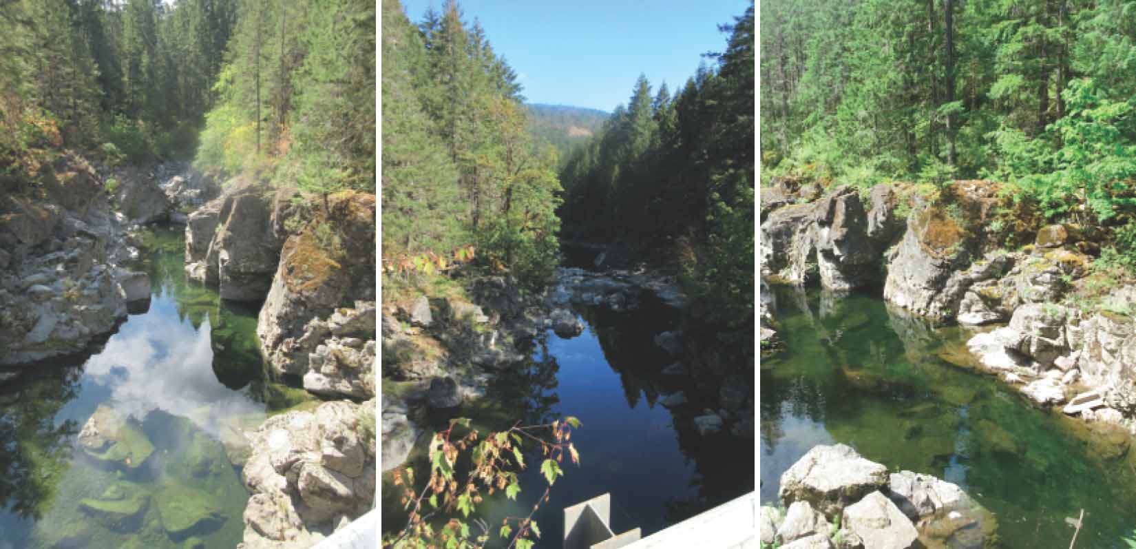
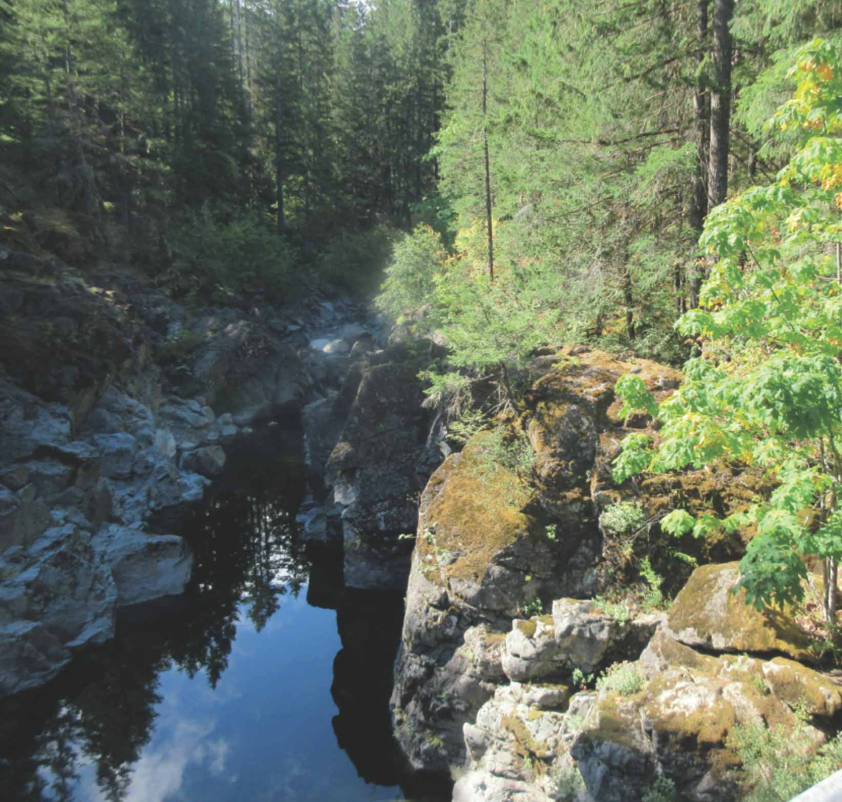
2.From the bridge, the views of the river’s convolutions and deep bowls are little short of amazing. Once across the bridge, stop to read the map of the park and volunteer-made trails leading all the way downstream to the Kinsol Trestle, and beyond. Walk the few steps up to an old gravel roadbed and turn left past the sign for Wild Deer Creek Trail. Start with a bit of a tromp, and a not particularly uplifting one, through small second-growth Douglas firs until you see a broad, gravel trail below the road on the left. The proper (signposted) trailhead for your trail is farther along the road ahead. However, impatient folk have beaten a well-worn shortcut down the bank to the trail.
3.Whichever way you get onto Wild Deer Creek Trail, turn left to begin a long descending trail curving to your right and bringing you to your first riverside vantage point. While this spot is pleasant enough, other spots a little farther upstream are probably more attractive and do have deeper pools.
CLOCKWISE FROM ABOVE LEFT The water remains crystal clear, except during winter storms; looking downstream from the bridge; The deepest pools are upstream from the access bridge; many deep pools remain, even at the end of a hot summer.
4.Regain the loop part of the trail, now running parallel to the Koksilah River and bringing you, past some large maples, to some other riverside spots good for picnicking, getting wet and so on. Once you’ve enjoyed what the river or your lunch pack has to offer, turn away from the trail to continue your loop walk. Soon you understand why the trail is named as it is. As two park signs will tell you, not only might you have to cross the creek bed but the creek bed is part of Wild Deer Creek.
5.The trail will deliver you back onto the old logging road, a couple of hundred metres away from the start of the loop. Make the easy stroll back to the bridge and your starting point.
Optional Add-On: Jack Fleetwood Trail
If you have the energy and curiosity to explore, on your return from Wild Deer Creek, carry on past the bridge along the gravel road for a few hundred metres. The road rises high above the river and is well back from it. When you come to Jack Fleetwood Trail, however, a beautifully built, wooden, raised staircase makes for an interesting and attractive descent to the river flats. Here, you can wander along a lovely trail surrounded by sword ferns and through firs and maples. This first section of trail is closest to the river, allowing you to get a good view of the largely bouldery, splashy water. Shortly after crossing a little bridge, the trail reaches perhaps the closest vantage point onto the river before heading away. You may wish to use this as your turn around spot since, from here, the trail, though reasonably pretty, is far away from the river. On the other hand, you may have planned for a bit of an adventure and arranged for a pickup at the Kinsol Trestle, 5 km distant. (See the Kinsol Trestle description next for the combination of trails at the other end.)