25. NIAGARA FALLS & TRESTLE WALK
Two easily accessible Wow-factor treats in Goldstream Provincial Park, linked by a dramatically switchbacking trail through large trees.
LOCATION
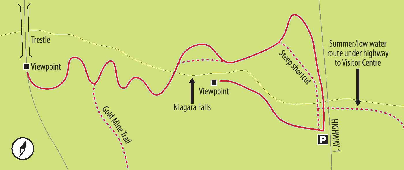
Goldstream Park is impossible to miss given that Highway 1 goes right through the middle of it. Driving north from Victoria, turn right off the highway and go to the parking lot closest to the Visitor Centre. This approach, however, is suitable only during the drier months. When the streams are running high (and the waterfall is most spectacular), safe and/ or comfortable access to these trails is possible only if you are driving south. The small, signposted parking lot is on the right as the highway completes its descent from the Malahat.
DISTANCE
1.5-km return
ELEVATION GAIN
90 m
This is probably not the best walk for small children with uncoordinated limbs or for anyone nervous about heights. The trail to the falls is a little narrow, even slippery at times, and the climb to the trestle, though not long, is a bit of a grunt. As for the sky-high trestle itself – well, it is a sky-high trestle. A firm grip and/ or obedient children are what you want.
SEASON
Summer for ease of visiting and general prettiness, autumn for combining walking with watching the chum salmon spawn, winter and spring for the most spectacular waterfall derring-do.
OF SPECIAL INTEREST FOR CHILDREN
Any child who is capable of being awed by height will be thrilled by the double heights, first of the falls, second of the trestle.
Step One: During Summer and Early Fall and/or When the Water Is Low
1.From the main parking lot, walk beyond the picnic area along the main trail. When you come to a fork, turn left towards the highway where a huge culvert/ tunnel goes under the highway. Make your way through this tunnel on the left side of any flowing water, only easily passable if the water level is low. When you arrive at the stream at the other side, follow the uneven trail along the stream towards the waterfall until you meet the main trail from the parking lot up the stairs to your left.
Step One: Late Fall through Early Spring and/or When the Water Is High
1.Having approached from the Malahat and parked in the small signposted lot, walk towards the stream and descend the sequence of sturdy steps towards the creek.
Onward: All Season
2.First visit the falls from this side of the creek, appreciating the fact that not only is this one of the highest, easily accessible falls on Vancouver Island but also it is one of the few where you can see the falls from a secure spot below the falls. Purportedly more than 47 m high, these falls are only a few splashes short of the other Niagara Falls. Width and volume are a somewhat different matter.
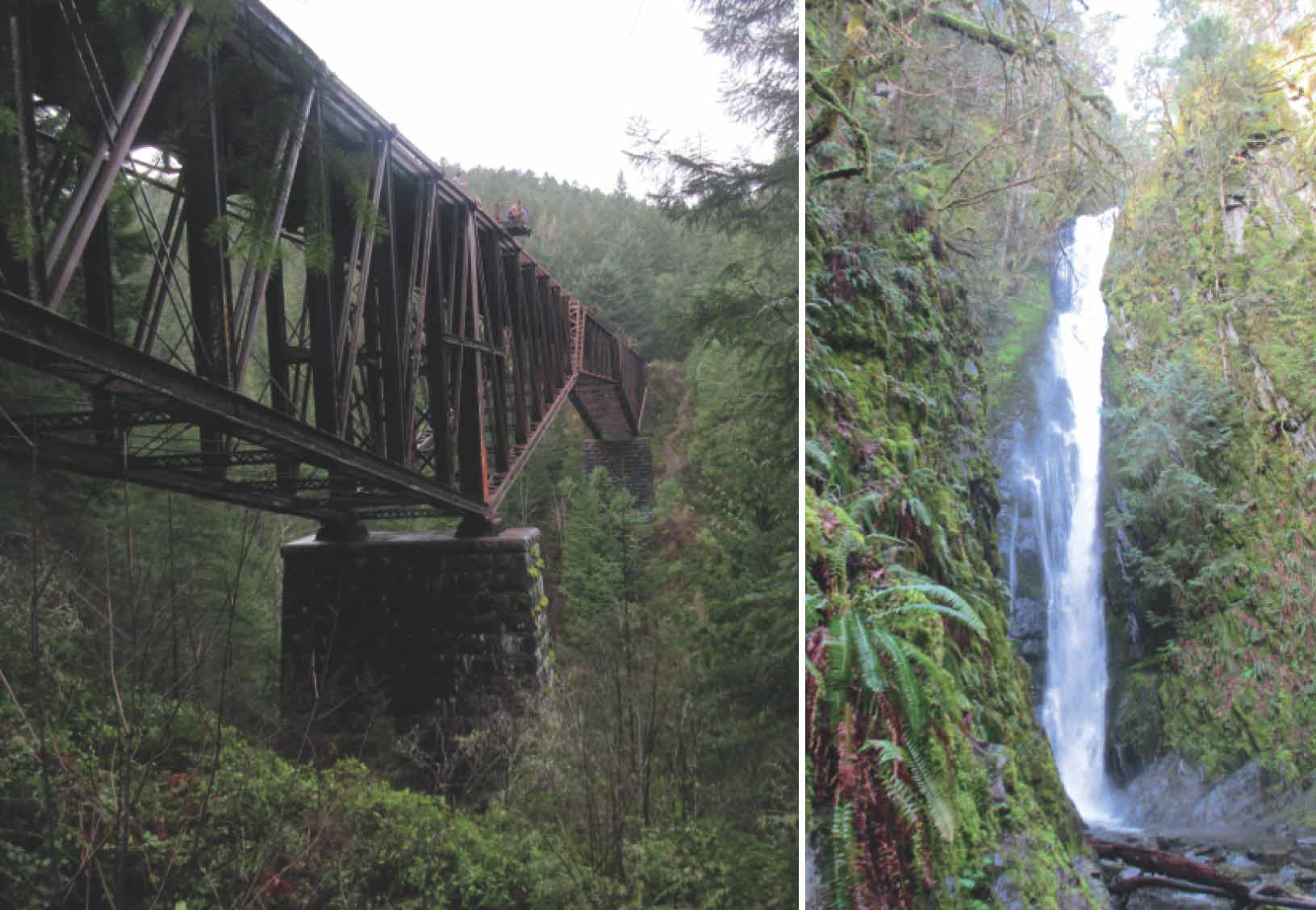
FROM LEFT The high trestle with small viewing platforms; Niagara Falls is almost as high as the gigantic falls of the same name.
3.Having taken your fill of photos, head downstream towards the highway. Immediately observe a rough track crossing the stream right above the tunnel and climbing precipitously up the bank on the other side. While your sense of adventure may compel you to take this route, you need not do so. The “official” trail is immediately next to the highway. Both these paths lead you to a small patch of old asphalt on the opposite bank.
4.Again, there are two routes. One narrow, rough track leads upstream along the edge of the gorge. The civilized route and official trail heads away from the stream; after a single, large switchback it turns back to join the rougher route.
5.Head upstream on the broad, regular trail at the top of the gorge. The trail dips away from the stream and, protected by a section of chain-link fence, directs you back towards the stream and a pretty-enough little bridge, fairly close to the swirling waters above the falls. Reassuringly, the bridge is not only sturdy but criss-crossed with protective bands, largely eliminating the chances of a small creature plummeting into the dangerous waters.
6.Cross the bridge and begin the sequence of switchbacks through a stand of cedar and fir. When you come to a fork in the trail, keep right, but make a mental note of the other fork in case you want to extend your walk with a side trip down Gold Mine Trail (unsignposted here) after visiting the trestle.
7.Several routes are worn up the last few metres to the railway tracks. When the tracks are not being used, you needn’t worry about a locomotive rushing towards you as you tread the airy heights of the impressive trestle. Checking, even with others who will almost certainly be there, will help. From the trestle itself, you have great views not only onto the treetops far below but also down the gorge towards Mt. Finlayson. (See Popular Day Hikes 4: Vancouver Island for directions on the hike up Mt. Finlayson.)
8.Returning the way you came, you may wish to explore along the clear, well-used trail to your right. If you follow it to the not-very-impressive vestiges of the historic gold mine, return the way you went: there is no good loop amongst these trails.
9.Once back to your car, you may well want to explore a little more of the park, particularly if you visit mid-fall for the chum salmon run. The Visitor Centre is also well worth a visit.