Some of the most beautiful, varied forest walks in the Victoria area, climbing around Mt. Newton to oak meadow viewpoints and dipping into gullies of huge trees.
LOCATION
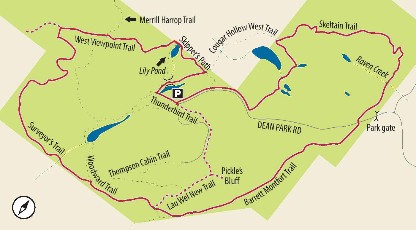
Driving north from downtown Victoria on the Patricia Bay Highway (17), pass Elk Lake, and, just under 7 km later, turn left onto Mount Newton Cross Road. Drive just under 1.5 km and turn right onto East Saanich Road. After just under 3 km, turn left onto Dean Park Road and go 2.8 km to the signposted John Dean Provincial Park entrance. Park in the main parking area at the end of the road.
DISTANCE
6.7-km loop (with shorter options)
ELEVATION GAIN
110 m, cumulative, over several short ascents and descents.
Wide, even paths in some sections, narrow and a little rocky in others. Some sections are a little steep and rocky but safe for almost all walkers.
SEASON
Spring and summer. Unlike the regional and municipal parks in the area, this provincial park is closed to cars from November to mid-March. Theoretically, it is possible to walk in, but signs discourage parking on most surrounding roads. April and May are superb for wildflowers.
OF SPECIAL INTEREST FOR CHILDREN
A colourful sign with wildflowers could inspire a good treasure hunt in spring and early summer. At this writing, small (plastic!) creatures lurk in nooks along two sections of trail. One of these, the last section of Skeltain Trail on the suggested route, makes a fitting enticement to finish the long loop. The other is Thunderbird Trail, a suggested optional extra.
While many cross trails allow variations, the combination below provides lots of variety of terrain and offers the option of a long adventure.
1.From the parking area, walk straight ahead and to the right, downhill, past the outhouses and the sign for Valley Mist Trail. After a short drop, turn right onto a smaller trail. After zigzagging down a slope past some huge firs, go right past a cairn. Pause to study the colourful sign for wildflowers to add spice to your onward quest and swing right past a damp area to a signed junction.
2.Turn right onto Skipper’s Path (also signed “Freeman King”) and, in season, start looking for trilliums. Cross a small bridge with the puzzling sign saying “Rambling.” At the next junction, ignore Bob Boyd’s Climb, turning left to keep on Skipper’s Path. Pass mostly cedars, sword ferns, of course, blankets of salal and one of many particularly stately old firs. When you come to the sign for the old gazebo site, carry on past the so-called Lily Pond and up a double flight of wooden stairs, past Valley Mist Trail.
3.Now on West Viewpoint Trail, find yourself contouring and climbing into lighter forest. Pass a snag thick with bracket fungus, an impressively large mossy log and lots of Oregon grape. Go straight ahead at the junction (and posted map), ignoring Woodward Trail, leading off to the left. When you get to a small branch, you can either make a quick out-and-back trip along this narrow track to get something of the view it offers, or you can turn left onto Surveyor’s Trail for your onward route and, as it happens, better views.
4.A striking formation of two large cedars and a fir deserves a photo at the very least. One of the huge, fire-scarred firs in the park also deserves a little attention and, possibly, some observations or reflections on the advantages of a thick skin! Descending to cross a tiny stone bridge, begin a climb until you pass another interesting old fir, this one (like others in the park) pocked by insect-hunting woodpeckers. When you reach signposted Cy’s Lookout, and a beautiful bed of April-blooming fawn lilies, you are treated to lovely (though screened) views over Saanich Inlet.
5.Continue to climb gradually as the ecosystem changes and becomes increasingly dotted with arbutus, Garry oaks and grassy meadows. A side trail descending through a large meadow brings you to another viewpoint extending south to Brentwood Bay, unfortunately, close to a house. Fear not: in April and May, shooting stars and camas are beautiful distractions. Linger by these high meadows, for within minutes you find yourself switchbacking down to Canyon Creek.
6.Once across the strategically placed stepping stones of the tiny creek, climb quickly up a rough rock staircase of sorts and past junctions to Woodward and Thomson Cabin trails on your left. This second sequence of oak and arbutus meadows is almost as pretty as the first, but within a few minutes the trail begins to descend through small trees.

CLOCKWISE FROM TOP One of many artful stream crossings, this one near Cougar Hollow; view of Saanich Inlet; a carpet of shooting stars in a meadow on the south side of the main ridge.
7.At the junction with Lau Wel New Trail you must make a major decision. While the recommended route lies straight ahead, you can cut the distance roughly in half by turning left here. Although this does shorten your walk, it does have the advantage of leading you close to Pickle’s Bluff, a particularly popular viewpoint. However, it takes you back to your car via some grim (but useful) structures at the high point of the mountain.
8.For the full loop, go straight ahead on the comparatively quiet Barrett Montfort Trail. This trail, contouring the mountain before gradually descending, has a feel to it quite unlike any of the other trails to this point. Narrow, but secure, the trail has something of a “real” mountain-trail quality, particularly as the bank steepens. With no junctions to think about, you can let your mind drift. Ultimately, the trail descends, levels out and brings you to the park road.
9.Climb the heavy-duty wooden staircase, cross the road and start straight ahead on “Barret” Montfort Trail West (Barret spelled here with one “t”). Pause at the inspiring sign with its photos of volunteers in the park before starting another section of contouring trail. More fire-scarred firs and more beds of fawn lily later, cross tiny Raven Creek and descend to the junction with Skeltain Trail.
10.Climbing along the sometimes-rocky path, come eventually to a mysterious junction with Cougar Hollow West Trail – mysterious because although signed, the trail (apparently out of the park) doesn’t appear on park maps. In any case, turn left to stay on Skeltain Trail, dropping down dirt-and-timber steps. This last section of trail is a fitting conclusion to your trek. Particularly varied in terrain and rich with magnificent trees, it also has (or has had, perhaps) tiny plastic creatures lining its flanks.
11.Once on the paved road, turn right for the short stride back to the parking lot. When you are back at your car, you may feel inspired to visit the summit. One incentive for children might be to pass a second gauntlet of tiny plastic creatures, or, more likely, to stand atop the high point. But don’t feel you are missing a wonderful experience if you opt out. Aside from a good view of Mt. Baker, you’re not. See the comments in stage 7.