
Looking downstream on the Potomac River from Split Rock
1 Split Rock
This hike heads to an overlook known as Split Rock. Look over the majestic scene where the Potomac and Shenandoah Rivers meet, where Virginia, West Virginia, and Maryland all come together, with the town of Harpers Ferry, West Virginia, lying below. This hike’s beginning is home to Harpers Ferry National Historical Park, where you can step back in time to early American manufacturing, railroad history, and Civil War drama.
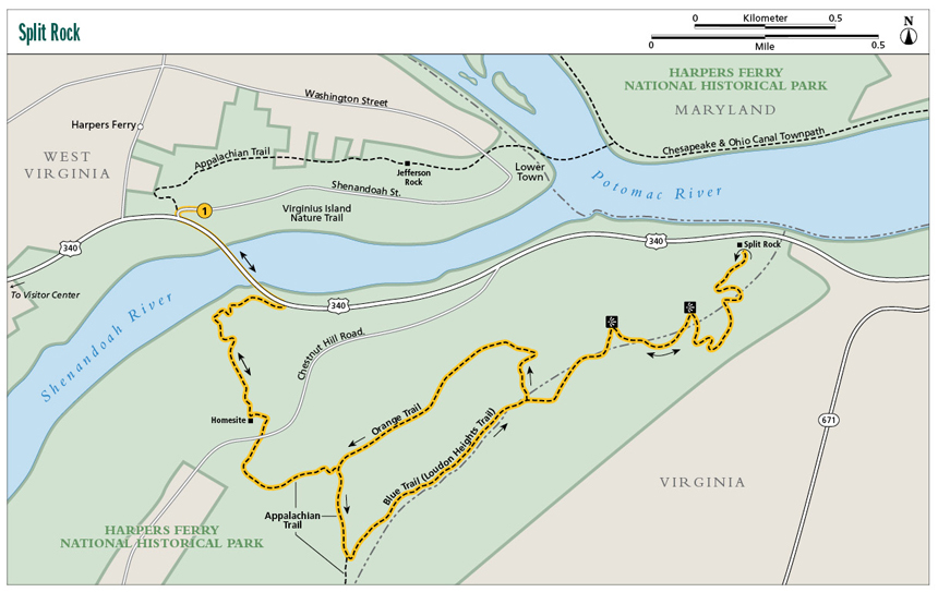
Start: Shenandoah Street off US 340
Distance: 6.2-mile balloon loop
Hiking time: About 3.5–4.5 hours
Difficulty: More difficult due to distance and elevation gain
Trail surface: Natural, except for bridge crossing
Best season: Whenever the skies are clear
Other trail users: None
Canine compatibility: Leashed dogs permitted
Land status: National historical park
Fees and permits: Parking fee required
Schedule: 24/7/365
Maps: Loudon Heights Trails; USGS Harpers Ferry
Trail contact: Harpers Ferry National Historical Park, PO Box 65, Harpers Ferry, WV 25425; (304) 535-6029; www.nps.gov/hafe
Finding the trailhead: From Berryville, Virginia, take US 340 north into West Virginia and stay with it, passing Charles Town and continuing into Harpers Ferry, West Virginia. Once in Harpers Ferry, look for the left turn onto Shenandoah Street just before crossing the bridge over the Shenandoah River. Follow Shenandoah Street just a short distance, then come to a fee parking area on your right, part of Harpers Ferry National Historical Park. Trailhead GPS: N39 19.2894' / W77 44.6448'
The Hike
This hike starts in an old town. Harpers Ferry was part of the colony of Virginia when founded in 1751 by Robert Harper. He saw the potential value of the area as a strategic transportation corridor as well as a source for ample waterpower, and garnered 125 acres at the peninsula where the Shenandoah River meets the Potomac River. The Virginia General Assembly officially recognized the place as “Shenandoah Falls at Mr. Harpers Ferry.” The town grew, and today, parts of the town’s historic area are protected as a national historical park.
The beauty of the place was undeniable then and remains so today. Thomas Jefferson himself came to Harpers Ferry in October of 1783. He described it as thus: “the passage of the Potomac through the Blue Ridge is perhaps one of the most stupendous scenes in nature. . . .” It wasn’t long after Jefferson’s visit that the United States Armory and Arsenal was established in 1799. Harpers Ferry transformed from riverside village to industrial town. For the next six decades, up until the Civil War, more than 600,000 firearms were produced. Waterpower was very important to manufacturing here, but the real industrial breakthrough came when John Hall first undertook manufacturing using interchangeable firearm parts, allowing rifles to be manufactured by machine rather than by hand. Other manufacturing followed the same idea. In the 1800s Virginius Island, located very near the trailhead for this hike, was an industrial powerhouse. Here, an iron foundry, tannery, machine shop, flour mill, and sawmill were all operating using the latest technology of the time. An interconnected network of nature trails explores this intriguing area.
Being at the confluence of two rivers and a mountain passage, it was not long before the canals and railroads made their way to Harpers Ferry. As the east pushed west and commerce needed a route through the mountains, the Chesapeake and Ohio Canal came through as well as the Baltimore and Ohio Railroad. These enhanced Harpers Ferry’s place as a manufacturing center.
Looking downstream on the Potomac River from Split Rock
The Civil War changed everything though. Being an important industrial, transportation, and arms-manufacturing locale, both sides prized Harpers Ferry. The town ended up changing hands between North and South eight times during the Civil War. Before that, as soon as Virginia seceded from the Union, Yankee soldiers protecting the arsenal set fire to it, preventing the Rebels from obtaining the armory. Back and forth the battling went. Stonewall Jackson captured more than 12,000 Union soldiers at one time in Harpers Ferry, the largest such capturing of the enemy in the entire Civil War. The town finally ended up in Union hands, and the Northerners used it as a base to raid the Shenandoah Valley.
This hike starts near the historic manufacturing base of Harpers Ferry before crossing a bridge over the Shenandoah River. The route uses the Appalachian Trail (AT) to climb Loudon Heights, the second-highest mountain above Harpers Ferry. The top of this mountain drops nearly 900 feet to the Potomac River. You will follow the AT to the Virginia / West Virginia state line, then take the Loudon Heights Trail (aka Blue Trail) along the state line to Split Rock. During the Battle of Harpers Ferry, Confederate soldiers drug cannons to the top of Loudon Heights and pounded Union positions. Interestingly, after the Union army recaptured Harpers Ferry, they established a series of campgrounds for soldiers on Loudon Heights despite its extremely sloped nature as well as its decided lack of water. It was a miserable existence. Later, Loudon Heights was abandoned by both sides.
But for modern-day hikers, Loudon Heights is a worthy goal. It now features resplendent forests growing among the rocky soils. Your vistas from Split Rock present views into three states—West Virginia, Virginia, and Maryland—as well as views of Harpers Ferry, the confluence of the Shenandoah and Potomac Rivers, and finally of the Chesapeake and Ohio Towpath running across the waters. And the view downstream on the Potomac ain’t too bad either!
While you are here, be sure to visit Lower Town, the historic district in Harpers Ferry, as well as Virginius Island and the national historical park visitor center. There is a lot of history right here at the confluence of the Shenandoah and Potomac Rivers.
 Thomas Jefferson described the view of the confluence of the Potomac and Shenandoah Rivers at Harpers Ferry as “being worth a voyage across the Atlantic.”
Miles and Directions
0.0From the parking lot on Shenandoah Street, walk up Shenandoah Street to the US 340 bridge over the Shenandoah River. Pick up the AT southbound on the bridge walkway across the Shenandoah River. (The AT northbound takes you into Harpers Ferry.) Soak in views of the rapids below and Virginius Island.
0.4The AT leaves left on steps after crossing the Shenandoah River. Cut under the US 340 bridge, then emerge south of US 340. Pass through a small clearing, then work up the south side of the Shenandoah River in rocky woods. Cruise along bluffs above the river.
0.6Turn away from the Shenandoah River, angling up the north slope of Loudon Heights in hardwoods.
0.9Pass through an old homesite just before crossing Chestnut Hill Road. Keep ascending.
1.3 Intersect the Orange Trail. Stay right (south), with the Appalachian Trail.
1.5Reach the crest of Loudon Heights and a trail intersection. Leave left from the AT, joining the much-less-used Blue Trail (Loudon Heights Trail). Travel northeast along the boundary of West Virginia and Virginia. The walking is easy here.
1.8Pass the stone foundation of a forgotten ridgetop structure. Descend.
2.1Meet the other end of the Orange Trail. This will be your return route. Continue right (east) on the Blue Trail, descending.
2.4Come near a power-line clearing and walk out to a warm-up view of the rivers and mountains below.
2.6Pass a second power-line view of the Tri-State area of Harpers Ferry. Continue downhill on switchbacks.
3.1Open onto Split Rock. From here, you can look at the confluence of the Potomac and Shenandoah Rivers, Maryland Heights and the C&O Towpath across the Potomac, and an extensive valley view to the east, as well as a look at Harpers Ferry. Backtrack.
4.1Meet the east end of the Orange Trail, leave right, descending, then level off on a mountainside bench. Head southwest.
4.9Intersect the AT. Turn right, northbound, and backtrack for the US 340 bridge.
6.2Arrive back at the Shenandoah Street trailhead, completing the hike.