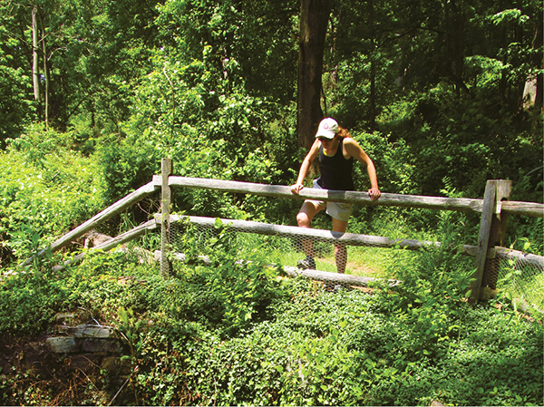
Hiker peers into an ice storage well
2 Bull Run Mountains Conservancy
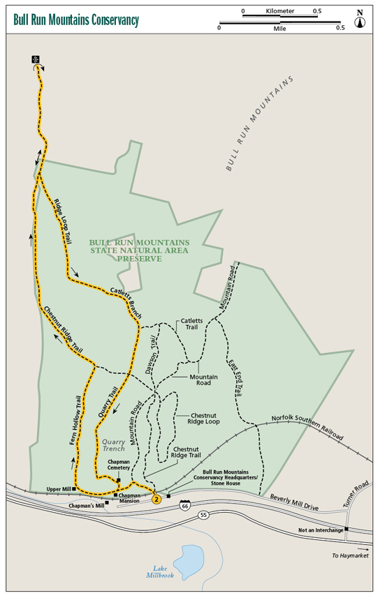
This hike adds a scenic overlay to the history contained within. Start at the south end of the Bull Run Mountains, first passing ruins of a tavern, then coming to huge Chapman’s Mill, once a thriving operation. From there, climb to an open rock outcrop with extensive views west to the Blue Ridge. Finally, backtrack to pass a hand-dug linear quarry and a family cemetery.
Start: Trailhead on Beverly Mill Drive
Distance: 4.7-mile loop
Hiking time: About 2.5–3.5 hours
Difficulty: Moderate; does have 1 extensive climb
Trail surface: Natural surfaces
Best season: When the skies are clearest
Other trail users: None
Canine compatibility: Leashed dogs permitted
Land status: Private conservancy
Fees and permits: No fee; liability waiver required
Schedule: Open daily year-round
Maps: Bull Run Mountains Conservancy Trail Map; USGS Thoroughfare Gap
Trail contact: Bull Run Mountains Conservancy Inc., PO Box 210, Broad Run, VA 20137; (703) 753-2631; brmconservancy.org
Finding the trailhead: From exit 40 on I-66 (Haymarket/Leesburg), take US 15 south for 0.3 mile to VA 55 west. Turn right and join VA 55 west for 2.6 miles to turn right on Turner Road. Cross over I-66 (no access) and then immediately turn left on Beverly Mill Drive. Follow Beverly Mill Drive 0.6 mile to the Bull Run Mountains Conservancy trailhead, just a little west of the Stone House. (The direct access for Chapman’s Mill is a little beyond the conservancy trailhead.) Trailhead GPS: N38 49.482' / W77 42.378'
The Hike
Broad Run cuts a narrow passage between the Bull Run Mountains to the north and the Pond Mountains to the south. This opening, known as Thoroughfare Gap, lies between the Blue Ridge and the Shenandoah Valley to the west and the Piedmont and the ocean to the east. Thoroughfare Gap has been a natural travel corridor door for as long as animals and aboriginal Virginians have been migrating. Since Virginia was an English possession, colonists have used the gap. As early as the 1600s, settlers and soldiers, traders and explorers have all made their way through this mountain passage. Today, I-66 links Washington, DC, to points west, passing through Thoroughfare Gap.
With that in mind, it is no surprise that history was made in this neck of the woods. And Virginians and visitors alike are fortunate that the Bull Run Mountains Conservancy stepped in in 1995 to protect the Bull Run Mountains and the history at Thoroughfare Gap. Add to that the additional layer of protection provided by those restoring Chapman’s Mill. (More about that later.) The Bull Run Mountains Conservancy manages 800 acres of the greater 2,486-acre Bull Run Mountains Natural Area Preserve.
After leaving the trailhead our hike takes us past the Chapman Mansion and icehouse. You can peer into the rock-lined pit where ice was stored for summertime use and look down upon the old Chapman Mansion. It was built by Jonathan Chapman, the same man whose family built the seven-story Chapman’s Mill, which you will soon see. The mansion is now mere stone walls.
Then you’ll come to Chapman’s Mill. Strategically located in Thoroughfare Gap, the mill capitalized on trade between the agriculturally prolific Shenandoah Valley and cities to the east such as Alexandria, where agricultural products could be shipped by boat to other points in the United States and beyond to other continents.
Hiker peers into an ice storage well
Times were good and they only got better when the Manassas Gap Railroad started passing through Thoroughfare Gap in 1852. This rail transportation sped up the process of getting grain to the mill and finished product to markets in the East. Chapman’s Mill was enlarged and brought up to seven stories in height. It is currently believed to be the tallest stone structure in the United States.
During the Civil War the Confederate Army turned the mill into a meat-curing warehouse and distribution center. Here, animals were processed and turned into meat rations for the Rebels. However, after the First Battle of Manassas, the Rebels burned the mill to prevent Yankee access. Next, during the Battle of Thoroughfare Gap on August 28, 1862, the mill changed hands three times. Soldiers climbed up the mill and shot out from its windows at the opposition. The Confederacy ultimately won the battle, allowing General Robert E. Lee to march east through Thoroughfare Gap and join the rest of the Rebels for the Second Battle of Manassas, which they also won.
In the 1870s the Beverly family restored Chapman’s Mill to operation. The mill took on their name. They stayed in business until 1951. Unfortunately, the mill burned in 1998, but attempts are being made at restoring the historic structure. A campaign known as Turn the Mill Around is under way to repair the site, which is listed on the National Register of Historic Places. For more information on this, visit chapmansmill.org.
Next, you will visit the remains of another, smaller mill, known as the Upper Mill. From there, take the Fern Hollow Trail up to a gap. Then join the Chestnut Ridge Trail as it leads to the crest of the Bull Run Mountains. From here, walk through oaks, pines, and rocks aplenty atop the ridgeline. Leave conservancy property using an easement to access a large rock outcrop framed with Table Mountain pines, presenting a stellar view toward points west.
Descend from this high perch, eventually joining the Quarry Trail. Here you will visit a hand-dug linear trench from which rock was extracted to build the mill and house for the Chapmans. Finally, stop by the historic Chapman Cemetery, then return to the trailhead.
 Chapman’s Mill provided cornmeal and flour for American troops for seven wars: the French and Indian, Revolutionary, War of 1812, Civil War, Spanish-American War, World War I, and World War II.
Miles and Directions
0.0Start by crossing the railroad tracks just a little west of the Stone House. Be sure to deposit your liability waiver, which you can print and fill out at home from the BRMC website. Immediately come to an intersection. Here, the Chestnut Ridge Trail leads right. Stay left.
0.1Come to another intersection. Here Mountain Road leads right. Stay straight, curving around a ridge rising to your right.
0.2Come to the connector to the Chapman Cemetery and the Quarry Trail. This will be your return route. For now, stay straight and shortly pass the ice pit and ruins of the Chapman Mansion. A fence borders the pit. Pass the overlook of Chapman’s Mill. The huge stone walls are impressive. I-66 roars in the background. Broad Run flows below.
0.4Pass the ruins of the Upper Mill. It also has newer relics, including a refrigerator. Turn up Fern Hollow, leaving the railroad, interstate, and Broad Run behind.
0.5Pass a cool spring enclosed in a concrete box on your left. Continue up the wooded vale.
0.9Reach a gap and join the Chestnut Ridge Trail. Head left on a broad path through oaks.
1.3Make the crest of Bull Run Mountain. A spur trail leads left; stay with the main, wide official path northbound.
1.8Intersect the Ridge Loop Trail. For now, keep straight and follow a conservation easement, a doubletrack trail, on private land heading toward the vista. Ascend.
2.3Come to the signed overlook, which splits west from the main easement. A wide panorama opens to the farms, fields, and forests below, and the Blue Ridge and mountains beyond. Look around at the ragged rock ramparts below the overlook. Backtrack.
3.5Come alongside Catletts Branch, gurgling to your left.
3.7Meet the Catletts Trail. Stay straight on the Quarry Trail.
3.9Come to a four-way intersection. Keep straight here, ascending on the Quarry Trail.
4.3Come to the Quarry Trench. Here, cross the hand-dug rock vein used to build Chapman’s Mill and home.
4.5Reach the Chapman Cemetery, enclosed in stone and wrought iron. Descend just a bit to complete the loop. Backtrack.
4.7Reach the trailhead, completing the hike.