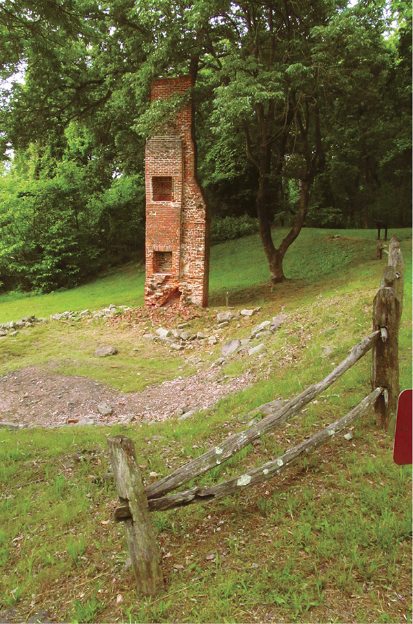
Two story brick chimney of the Fairfax home
5 Leesylvania State Park
This hike travels hills above the tidal Potomac River. Leave the scenic shore—ideal for a picnic—to climb to Freestone Point and a Civil War battery featuring a stellar view of the river and Maryland beyond. From there, visit the site of Fairfax, a home from the early 1800s. More woodland winding leads up to the historic Lee homesite, Leesylvania, dating back to before the United States was a country. Pass the Lee home garden and cemetery amid more hilly mature forest, then return to the riverside picnic area.
Start: Freestone Point Picnic Area
Distance: 1.6-mile figure-eight double loop
Hiking time: About 1.5–2 hours
Difficulty: Easy; does have hills
Trail surface: Natural surfaces
Best season: Any time the skies are clear for views
Other trail users: None
Canine compatibility: Leashed dogs permitted
Land status: Virginia state park
Fees and permits: Parking permit required
Schedule: Open daily year-round
Maps: Leesylvania State Park; USGS Indian Head, Quantico
Trail contact: Leesylvania State Park, 201 Daniel K. Ludwig Dr., Woodbridge, VA 22191; (703) 730-8205; virginiastateparks.gov
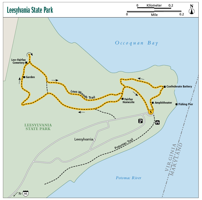
Finding the trailhead: From exit 152 on I-95, south of Washington, DC, take VA 234 south for 0.4 mile to a traffic light and US 1 (Jefferson Davis Highway). Turn left on US 1 north and follow it 2.6 miles to a traffic light. To the left is Cardinal Drive and to the right is Neabsco Road. Turn right on Neabsco Road and follow it for 1.4 miles to the right turn into Leesylvania State Park. Follow Daniel K. Ludwig Drive through the state park for 2.2 miles to reach a traffic circle and the Freestone Point Picnic Area. Parking is on the right, just before the traffic circle. The Lees Woods Trail begins on the left-hand side of the traffic circle. Trailhead GPS: N38 35.472' / W77 14.895'
The Hike
Talk about packing history into a hike. The Lees Woods Trail, a figure-eight double loop, may have more history per foot than any other trail in this guide. For starters, George Washington is involved. More about that later. Leesylvania Plantation, located on a fertile peninsula overlooking the Potomac, was valuable not only agriculturally but perhaps even more so due to its strategic location on the river: Crops and other valuables—as well as landowners themselves—could be transported by water on the river. This part of the Old Dominion was lightly populated (hard to believe compared to now). Even the best of roads were rough, muddy, and dangerous. Having water transportation gave a planter a huge advantage.
Henry Lee II saw this advantage. He built his hilltop house, Leesylvania, with an eye not only for a commanding view of his grounds and fields, but also to access the river and its shipping possibilities. He could send his products upstream to the Falls of the Potomac or down to the Atlantic Ocean, enabling him to trade throughout colonial America or even with the mother country, England, across the sea.
It was by water that America’s first son, George Washington, would come and go on his visits to Henry Lee and Leesylvania Plantation. See, Henry and George were friends, fellow planters with a bent for discussing current events, whether they were the latest agricultural practices or an impending national revolution. Therefore, when you visit the Lee homesite, Leesylvania, remember that George Washington slept there too. Imagine the site as bordered by fields, with many working hands about. The hilltop homesite is wooded now and is harder to visualize in its former grandeur.
Two story brick chimney of the Fairfax home
Therefore it happens that this piece of ground in Prince William County, now nearly engulfed by the Washington metroplex, was one of the earlier estates in the Old Dominion. Later, Alfred Lee, grandson of Henry Lee and father of Robert E. Lee, sold the Leesylvania Plantation site (the plantation house had burned down in 1790) to Captain Henry Fairfax. He bought the 2,000-acre plantation in 1825. Fairfax then built his own brick structure, the remains of which you can see on the hike. Fairfax’s manse was built about a half mile from the Lee residence. Fairfax resided there for twenty-two years, raising seven offspring on the site. And what a site it is. Set on a hill, the original house had a wide porch overlooking the Potomac. A yard sloped down to the water, where a landing and beach lay. Even today, park visitors walk themselves and their dogs and play along this shore. The Fairfaxes and Lees saw the economic and aesthetic value, whereas today we hold dear the land for its natural, recreational—and historical—value. The home remained in the Fairfax family until 1908, when the home was burned. The brick foundation, walls, and chimneys are all that remain of the Fairfax home.
Later on the hike, you will visit the cemetery where the Fairfaxes and Lees are buried, though the headstones of the Lees were stolen and the Fairfaxes’ removed.
History happens right out of the blocks on this hike. You will first pass the site of a 1920s hunting lodge, the Freestone Point Hunt Club, from back when this was a sleepy rural area. It was built by New York businessmen with a liking for waterfowl hunting on the Potomac as well as easy access to the lodge by rail. Time marched on and the two-story rustic lodge passed through other hands. Urban encroachment and unregulated hunting did in the waterfowl and the lodge was eventually taken down.
Ahead you will find the site of a Confederate battery that was erected in September 1861, with three cannons and a commanding view of Occoquan Bay and the Potomac River. It was not but a few days before they skirmished with Union boats on the Potomac. The cannons are gone but the majestic panorama remains.
Next in order are the homesite of Fairfax, then the Leesylvania Plantation site. Beyond are the Leesylvania Plantation gardens, then the cemetery, as discussed above. Lastly, take a spur trail to a ravine and a spot where the Alexandria and Fredericksburg Railroad was put through in the 1870s. The steep hills required deep cuts in the hills. Landslides occurred much too frequently, however, and the rail line eventually was abandoned.
 Henry Lee II, who established the first plantation in what is now Leesylvania State Park, was the great grandfather of Confederate General Robert E. Lee.
Miles and Directions
0.0Start on the signed Lees Woods Trail, located on the traffic circle and the end of the park road. You will see a footpath, broken by wooden-and-earth steps, leading uphill toward the park amphitheater. Do not take the gated gravel road uphill from the traffic circle. And do not take the trail leading toward the park fishing pier through the picnic area. Immediately pass the park amphitheater. It was built on the site of an old hunting lodge—the Freestone Point Hunt Club—built in the 1920s. The fireplace still stands. Continue climbing through mature forest of oak, holly, and pawpaw.
0.1Reach Freestone Point Battery and an overlook of the Potomac River and Occoquan Bay. Soak in long-range vistas and check out the earthworks protecting the cannons stationed here. The trail circles away from the overlook and cruises through forest on the edge of the bluff above Occoquan Bay, shaded by regal oaks.
0.3Come to a trail intersection. Here, stay right, then head left for the Fairfax Homesite. View the remains of the brick building, which was built in 1825 and burned down in 1909. Check out the two-story chimney. Note the old well nearby, used by the Fairfaxes for drinking water. Continue walking a wide track that was part of the access road used by the Fairfaxes.
0.5A spur trail comes in on the left, leading down to the main park road. Stay straight.
0.7A fire road leaves right and shortcuts the Lees Woods Trail. Stay left.
0.9Reach the site of Leesylvania after climbing a hill. This is where Henry Lee II resided and George Washington visited. The home was built in the 1750s. Leave the homesite, passing by the gardens of Leesylvania. A short mini-loop circles the garden site. Walk through hills.
1.0Come to the Lee-Fairfax Cemetery, enclosed by a wrought-iron fence. The headstones are missing. Head left from here and shortly reach an interpretive sign overlooking a ravine. Here, a now-defunct railroad line was put through. Backtrack to the cemetery and continue the loop.
1.1Pass the other end of the fire road bisecting the loop. Keep straight on a narrow ridge.
1.5Return to the trail intersection near the Fairfax Homesite. Turn left here, downhill, then split right. Descend on a wide track, passing near the park amphitheater.
1.6Emerge at the trailside traffic circle near the picnic area, ending the hike.