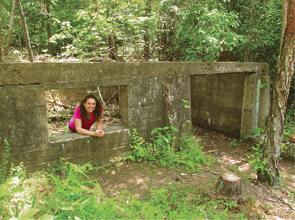
Hiker poses amid ruin of pyrite mine.
6 Prince William Forest Park
Even the founding of this woodland haven outside Washington, DC, is historic. Established as a demonstration work camp built by the Civilian Conservation Corps during the Great Depression, Prince William Forest Park offers a chance to see the trails, camps, and buildings of the area, as well as explore a pyrite mine operated along Quantico Creek. Also, view some eye-pleasing cascades along the streams in addition to one of the largest preserved tracts of Piedmont forest in the Old Dominion.
Start: Pine Grove Picnic Area near the park visitor center
Distance: 7.1-mile balloon loop
Hiking time: About 3.5–4.5 hours
Difficulty: Moderate to difficult due to distance
Trail surface: Natural surfaces
Best season: Year-round
Other trail users: None
Canine compatibility: Leashed dogs permitted
Land status: National park
Fees and permits: Entrance permit required
Schedule: Open daily year-round
Maps: Prince William Forest Park; USGS Quantico
Trail contact: Prince William Forest Park, 18100 Park Headquarters Rd., Triangle, VA; (703) 221-7181; www.nps.gov/prwi
Finding the trailhead: From exit 150B on I-95, south of Washington, DC, take VA 619 (Joplin Road) west just a short distance and reach the entrance to Prince William Forest Park. Turn right onto the entrance road and follow it 0.4 mile to the Pine Grove Picnic Area, near the park visitor center. Trailhead GPS: N38 33.585' / W77 20.863'
The Hike
The very establishment of Prince William Forest Park has a historic bent about it. In the 1930s, with the United States deep into economic woes, President Franklin Delano Roosevelt instituted a taxpayer-sponsored work program known as the Civilian Conservation Corps (CCC). The program’s goals were to reduce unemployment and teach job skills. Young men enrolled in the CCC were chosen to develop parks throughout the United States. Some parks to be established were known as Recreational Demonstration Areas, designed to transform marginal farmland into recreation destinations.
Negligible farmland located on Quantico and Chopawamsic Creeks was purchased by the United States to establish the Chopawamsic Recreational Demonstration Area. The CCC went to work developing a “camp for low income, inner-city children and families to get away and experience the great outdoors.” Since this camp was close to the capital, it was to be a showcase for the CCC. By the summer of 1936, the Chopawamsic RDA was open for business, with nearby city dwellers learning the ways of the woods. The CCC continued to work, building cabins, bridges, dams, and roads. Three major camps were located within the park and more than 2,000 CCC enrollees mustered through the ranks over a seven-year period.
Then World War II came along. The CCC was simply defunded and potential enrollees instead went into the armed forces. The park went into war mode as well and was transformed into a military installation—including a secret camp to train spies. The southern end of Chopawamsic RDA became a training area for the Office of Strategic Services, the forerunner to the CIA. They stayed in some of the cabin camps developed by the CCC and trained as spies. This spy tradition continues to this day. Much of the park along Chopawamsic Creek, located south of current-day Prince William Forest Park, became part of the Quantico military reservation.
Hiker poses amid ruin of pyrite mine.
That is how Prince William Forest Park and Quantico came to be. The establishment of the Cabin Branch Mine that you will see on this hike occurred earlier. In 1889 the Cabin Branch Mining Company was established. Set along the banks of Quantico Creek, the mine’s objective was pyrite, commonly known as fool’s gold. Though it sparkles, pyrite has no aesthetic value. It is, however, used in making paper, gunpowder, and soap.
A full-fledged operation was built here, from the mineshafts to the rail lines that moved the mineral, to a large processing area and a community for the miners. Today, we can see vestiges of this industrial past nestled in the woods bordering Quantico Creek.
Interestingly, the trail system we use to visit the mine and other places was initially laid out by the CCC. The Pine Grove Picnic Shelter, located at the trailhead, is a good example of the many structures built during that time. They all share the commonality of being rustic wood-and-stone buildings in the pioneer style commonly seen in our national park system (Prince William Forest Park is operated by the National Park Service). Enjoy this preserved legacy of the 1930s.
 From 1942 to 1945 the cabin camps of the park were turned into “spy camps,” training centers for armed forces personnel to learn the subterfuge business.

Miles and Directions
0.0Start by walking northwest through the Pine Grove Picnic Area from the historic Pine Grove Picnic Shelter. Pass by picnic and play areas, as well as a restroom building. Other trails and alternate parking are located south of the picnic area.
0.2Begin the actual Laurel Trail Loop, a path leaving the corner of the picnic area as a signed trail. Descend through rich woods of pine, dogwood, oak, and beech.
0.5Come to a major trail intersection. South Orenda Road, closed to public cars but open to bicyclers and hikers, comes in on your left. The continuation of the Laurel Trail loop leaves right. Keep straight and descend to a footbridge spanning South Fork Quantico Creek. Meet the South Valley Trail. Turn right, heading downstream with South Fork Quantico Creek flowing to your right. Enjoy mountain laurel blossoms in spring.
1.3Reach a trail intersection after passing through wooded bottoms and over a bluff. Pyrite Mine Road leaves left. You, however, cross Quantico Creek just above its confluence with South Fork Quantico Creek and immediately turn left, away from private property, joining the North Valley Trail. The bridge crossed was built in the late 1800s and was part of the mining effort. Cruise an old roadbed upstream, with Quantico Creek to your left.
1.5Enter the Cabin Branch Mine area. Come to a concrete structure, the remnants of the former miner commissary. The many pines in the area indicate disturbance. Join a boardwalk crossing former mine tailings.
1.6Reach the Old Mill Overlook. Here, across the creek, was the main mine-processing location. For more than thirty years, pyrite was processed here. The area was denuded of vegetation and Quantico Creek was compromised. However, in 1995 the mine was reclaimed. Mines were capped, tailings were buried, and trees were planted. Today, barren ground now harbors plant life and the area is on a long-term recovery. The stream is no longer absorbing sulfur and other pollutants. Continue up Quantico Creek, passing a capped mine bordered by a fence.
1.8Bridge Quantico Creek and meet the Cabin Branch Trail. Stay right, heading upstream along the North Valley Trail.
1.9Pass the foundations of mine buildings, including an engine room, boiler room, and machine shop, elements of a mining operation that extend beyond the actual mine. Continue up Quantico Creek, leaving the greater pyrite mine area. Soak in the natural beauty of this Piedmont woodland.
2.7Intersect the Geology Trail. Stay right along Quantico Creek on the Geology Trail. Pass through a narrow gorge with a series of cascades pouring over rock.
2.9The trail dead-ends at a second series of cascades and open rock slabs on Quantico Creek. Do not continue upstream on a user-created trail. Backtrack just a short distance, then ascend away from Quantico Creek.
3.1Meet the North Valley Trail. Stay straight on the Geology Trail.
3.4Come to Lake One Road. Turn left and join the doubletrack path south.
3.5Leave right from Lake One Road on a singletrack path leading to Parking Area E. Pass through a pretty picnic area with parking. Cross Scenic Drive, then join the Mary Bird Branch Trail.
4.0Come to bottomland and Mary Bird Branch. Cross the bottom on a boardwalk, then bridge Mary Bird Branch. Climb away from the valley.
4.1Come to the Old Black Top Road. Turn left and walk past a gate, coming to the Turkey Run Ridge Ranger Station, group campground, and trailhead parking area. Keep south along the paved Turkey Run Ridge Access Road, passing a parking area on your right.
4.2Leave left on the singletrack Turkey Run Ridge Trail. Roller-coaster south on the ridge, running parallel to Scenic Drive.
5.0Cross Scenic Drive.
5.6Meet the South Valley Trail after descending to South Fork Quantico Creek. Head left. Enjoy streamside hiking after climbing a bluff.
6.4Meet North Orenda Road. Stay right on the roadbed and keep downstream along South Fork Quantico Creek.
6.6Return to the bridge crossing South Fork Quantico Creek and complete the loop portion of the hike. From here, cross the bridge and backtrack south on the Laurel Trail Loop.
7.1Return to the trailhead after passing through the Pine Grove Picnic Area, finishing the hike.