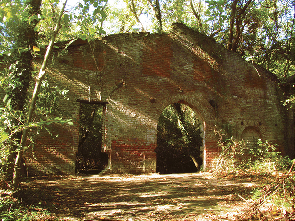
The brick wall of an iron forge recalls early Virginia history.
10 Belle Isle
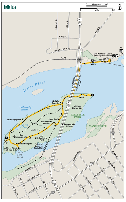
An Indian village, a Civil War prison camp, an iron foundry, a rock quarry, and now a city park . . . Belle Isle, on the National Register of Historic Places, is a history museum unto itself, smack-dab in the middle of the James River. Today you can visit the locales where it all happened, and see relics of the past on trails that lead to and through the island, all set in natural beauty amid the rapids of the James. Interior paths extend beyond the described loop, allowing for extended rambling and additional discoveries.
Start: Near the Civil War Visitor Center at Tredegar
Distance: 2.4-mile loop with spurs
Hiking time: About 2–2.5 hours
Difficulty: Moderate
Trail surface: Concrete, gravel, dirt, pavement
Best season: Year-round
Other trail users: Bicyclers, joggers
Canine compatibility: Leashed dogs permitted
Land status: City park
Fees and permits: None
Schedule: Open daily year-round
Maps: Exploring the James Guide; USGS Richmond
Trail contact: James River Park, 4001 Riverside Dr., Richmond, VA 23225; (804) 646-8911; jamesriverpark.org
Finding the trailhead: From exit 74A on I-95 in Richmond, take the Downtown Expressway to the first exit, Canal Street. Follow Canal Street to South Fifth Street. Turn left on South Fifth Street and follow it to the dead end at Tredegar Street. Turn right on Tredegar Street. The trail starts just before you pass under the Lee Bridge. Parking for the Belle Isle hiking trail is located near the Lee Bridge on the north side of Tredegar Street. Hourly parking is also available at the Civil War Visitor Center on Tredegar Street. (Both lots open after 9:30 a.m. weekdays to deter commuter parking.) Trailhead GPS: N37 32.080' / W77 26.809'
The Hike
This hike is one of Virginia’s most interesting for reasons historic, scenic, and logistical. Part of James River Park, Richmond’s fantastic set of destinations astride the James River, Belle Isle is first reached on an innovative and exciting pedestrian suspension bridge hanging under the Robert E. Lee Bridge (US 301). It then descends to Belle Isle, where a loop hike exploring layers of Virginia history unfolds.
A rich forest overlays granite on this 65-acre teardrop-shaped island, bordered by rocky shoals. Come to a flat upon reaching the isle—the place where Powhatans farmed and were visited by none other than Virginia’s first settler, Captain John Smith, in 1607. Richmond’s founding family, the Byrds, owned the island until the 1770s. In the early 1800s the river’s waterpower was harnessed by a nail-making factory.
During the Civil War Yankee soldiers were incarcerated on Belle Isle. The Belle Isle prisoner camp was a rough and dangerous place. The prison had no walls but was encircled by a low earthen hump of land. Confederate guards picketed the main area, aided by constantly manned cannon emplacements atop an island hill, which then had hardly a tree upon it. Union soldiers were promised if they crossed the earthen hump, they would be shot dead, leading the encirclement to be called a “dead line,” the precursor to the term in common use today, meaning “due date,” at least for us authors.
The loop trail heads upstream along the James, passing Hollywood Rapids, named for the cemetery across the river. These Class III–IV rapids challenge whitewater kayakers and provide a sonorant background for this hike. You cannot resist heading to the rocks where whitewater flows and herons feed. Belle Isle sits amid the 7 miles of shoals that played a major role in Richmond’s founding and very placement on the map. These rocks provide excellent views across the river.
The brick wall of an iron forge recalls early Virginia history.
Ahead, the trail curves past a quarry where granite was extracted after the Civil War. The main pit is now a fishing pond. Reach a picnic shelter and the west island tip. A spur trail leads to Civil War gun emplacements atop a hill to your left and a trail leads right to First Break Rapid.
More history waits ahead as you curve around the island’s south side. Here lies a millrace and remains of an old plant, the Virginia Electric Power Company, in operation from 1904 to 1967. Be careful around the metal remnants of this plant. User-created trails wind amid the works. An official spur trail leads to the South Side Rocks, a series of massive boulders great for hopping, normally with little water between them. This access trail travels over the head of the millrace that funneled water into the hydroelectric plant.
An iron forge from an earlier time greets hikers as they meet the south side access to Belle Isle. Only a windowed brick wall remains, standing eerily astride the trail. You will also see a stone shed, once used as a dynamite shack. Imagine all the noise and industry and men raking over Belle Isle. What stories these relics of the past could tell!
Your adventure isn’t over when you complete the loop and return to Lee Bridge. A side trip to the island’s east tip presents extensive river and downtown views, as well as the preserved remains of the Old Dominion Iron and Steel Company, which operated here until 1972. Yet more trails meander among the hills of the island center if you wish to explore further. Be apprised the interior trails can be confusing, as mountain bikers have created additional paths outside of the official ones.
 A significant number of prisoners incarcerated at Belle Isle were from the South. Members of East Tennessee’s 2nd Volunteer Infantry decided to side with the Union, were captured, taken to Belle Isle, and shown the wrath of the Rebel guards due to their disloyalty to the Confederate cause.
Miles and Directions
0.0Start near the Civil War Museum at Tredegar; join the paved path westbound along Tredegar Street above the James River. Arrive under the Robert E. Lee Bridge. Turn up the path looping to the suspension bridge under the Robert E. Lee Bridge. Cross the James River, enjoying stellar views. Note the old Richmond & Petersburg Railroad pilings below that once connected Belle Isle to downtown Richmond. It was known as the “Bridge of Sighs” for the feelings of dread when Union soldiers first saw infamous Belle Isle prison camp.
0.2Return to land and reach Belle Isle. A plethora of interpretive information and sites lies immediately in front of you. It is hard not to aimlessly wander about. For a methodical exploration of the island, head right, upstream along the James River, passing through the old Civil War prison site. Reach the loop portion of the hike. Stay right, entering woodland of sycamore, as another path heads uphill to the island interior.
0.7Pass Hollywood Rapids. Spur trails lead to the rocks, great for sunning or accessing the water. The old granite quarry site lies ahead, in operation during the late 1800s and early 1900s.
0.8Pass the still Quarry Pond, which features a fishing dock, on your left. This loop keeps westerly along the margin between the still pond to your left and raucous river rapids on your right.
0.9Reach a picnic shelter and a spur trail leading right to the island head. Another trail leads left and uphill to gun emplacements, then along the high center of Belle Isle. Still another trail leads to a boat ramp at First Break Rapid. Curve around to the quiet south side of island.
1.1A spur trail leads right across the millrace headgate to a ladder accessing the South Side Rocks. This is a fun place to boulder-hop and enjoy some of the natural features of the James River. The main loop trail runs alongside the millrace to your right.
1.3Pass the old hydroelectric plant on your right. It is not a safe place to explore, but user-created trails wind among its vegetation-covered remnants.
1.4Reach a trail junction. Here, a wide track leads acutely left to the island’s interior.
1.5Pass the brick wall of an iron foundry to the right of the trail, then reach an intersection. Here, a trail leads right to the James River’s south shore. This loop heads left back in the flats near the Robert E. Lee Bridge. Note the mountain bike skills area within sight of the foundry.
1.6Complete the loop portion of the hike after passing the stone dynamite shed. From here, head right, walking toward the east island tip, passing under the Old Dominion Iron and Steel Company frame.
1.8Reach the east end of Belle Isle. Soak in excellent views of the city and the James River. Begin backtracking to the trailhead.
2.0Start crossing back over the “bridge under a bridge,” returning to the mainland.
2.4Reach the trail’s end along Tredegar Avenue near the Civil War Visitor Center at Tredegar.