
The Canal Walk traverses old art-filled buildings.
11 Canal Walk at Richmond
On this hike you will explore Richmond’s riverside past, showcased after years of underappreciation. This urban hike in the heart of downtown starts at Brown’s Island, then goes along restored canals originally dug for boats to circumvent the rapids of the James River. It goes around, under, and over the modern infrastructure while interpreting the interaction of yesteryear’s peoples and this locale. The Canal Walk consists of hard surface for its entire distance. It is fun to follow the trail and absorb the numerous informational displays, including medallions inlaid onto the pathways.
Start: Near Civil War Visitor Center at Tredegar
Distance: 2.0-mile figure-eight loop
Hiking time: About 2–2.5 hours
Difficulty: Easy
Trail surface: Concrete
Best season: Year-round
Other trail users: Commuters, history buffs, runners, diners
Canine compatibility: Leashed dogs permitted
Land status: City park
Fees and permits: None
Schedule: Open daily year-round
Maps: Canal Walk; USGS Richmond
Trail contact: City of Richmond, 900 E. Broad St., Richmond, VA 23219; (804) 646-7000; richmondgov.com
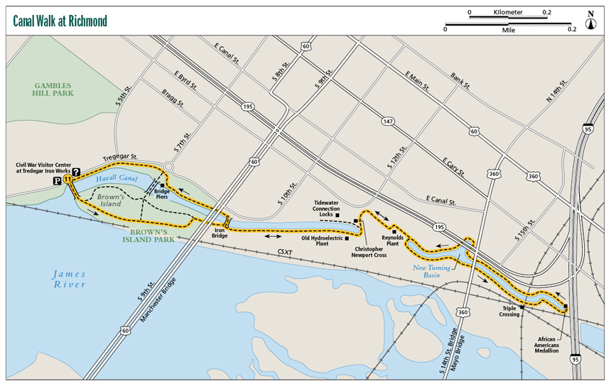
Finding the trailhead: From exit 74A on I-95 in Richmond, take the Downtown Expressway to the first exit, Canal Street. Follow Canal Street to South Fifth Street. Turn left on South Fifth Street and follow it to the dead end at Tredegar Street. The trail starts near the intersection of Tredegar and Fifth Street at the bridge onto Brown’s Island. Parking here can be tricky. Hourly parking is available at the Civil War Visitor Center on Tredegar Street, or you can park at the Belle Isle hiking trail locale under the railroad tracks beyond the museum. (Both lots open after 9:30 a.m. weekdays.) Trailhead GPS: N37 32.080' / W7 26.809'
The Hike
In establishing the Canal Walk, the city of Richmond demonstrated real commitment to preserving its past, especially when you consider how the Canal Walk was integrated into today’s infrastructure. And combined with other historic attractions downtown, from Belle Isle to the Civil War Visitor Center at Tredegar, you can spend a full day exploring the important pieces of Virginia’s past, a living timeline stretching from the late 1600s to today. In addition, while strolling along the restored canals of downtown, you can learn about history through displays and enjoy the watery views as well as food, fun, and entertainment, plus get a little exercise while doing it. So, don’t feel bad when you order extra cream in your latte while watching others travel the multimillion-dollar route ingeniously laid out through and under—even over—the downtown infrastructure.
The route is marked and signed, not only for directions but also with notable information. It is a must-see for history buffs. Strategically located emergency phones are there to ease your downtown walking worries. It will be hard to get up a head of steam as you stop to learn the information on the medallions embedded into the concrete walkway, as well as other signage. Water borders the route nearly its entire way, which adds scenic value to a historic overlay that covers various eras, from when no white man roamed the shores of the James River to the heady railroad days when tracks spread like veins over the land, resulting in the famed Triple Crossing.
On your first trip you will be wondering how the Canal Walk was integrated into the downtown riverfront. First, join a walkway connecting to Brown Island and explore that piece of land. The walk then saddles alongside the Haxall Canal. Interestingly, the Haxall Canal started in 1789 as a simple millrace, designed to turn a grinder and process grain for consumption. The millrace was later extended and deepened as part of the canal system built to allow boats to head up- or downstream along the James without having to navigate the rapids astride Richmond and beyond.
The Canal Walk traverses old art-filled buildings.
Civil War significance is never far away in Richmond. This walk passes piers of the rail bridge that brought Jefferson Davis to his inauguration as president of the Confederate States of America. See where the world’s first electric trolley transportation system began. Back in 1888 Richmond’s public transit system consisted of horse-drawn carriages, but then an electric line was developed using energy generated by the outflow of the Haxall Canal. These electric-powered trolleys ran through downtown and beyond for six decades, providing an interconnected artery of electric transportation. But widespread use of cars did them in.
Of course, the canals themselves are historic, built in the late 1700s through the 1800s to allow boats to travel around the rapids of Richmond, expanding commerce. When the first part of the first canal was opened in 1790, it was the first commercial canal in the United States. Remember, these canals were hand dug. It was part of a greater canal network linking Lynchburg and Richmond. In the 1850s more than 200 boats a day were using the locks and canals, greatly enhancing trade between the western part of the Old Dominion and the capital city. It seems Richmond has been at the forefront of transportation changes! Like most canals throughout the nation, railroads were the undoing of the canals. In the 1880s rail tracks were laid over the towpath next to the canal. Floods damaged the locks and they fell into despair. The canals along the walk have been restored.
Visit the cross laid by early English explorer Christopher Newport, who interacted with the Powhatan Indians stationed along the rapids of the James River. Upon landing at what became Richmond, he found an Indian village here. The falls of the James River had been an intersection of aboriginal trade routes well before Newport considered crossing from England to what became Virginia.
The Triple Crossing represents another layer of history here on the waterfront. As its name hints, the Triple Crossing was the world’s first three-way railroad intersection. Consider a break in your walk with a boat cruise on the lower Tidewater Connection Locks. You will take a 40-minute ride on the old canal. Your guide narrates the boat tour, with a heavy emphasis on history. Tickets can be purchased at the New Turning Basin. On your return trip look beyond the walk at the high-rises of downtown and the river in the distance, and ponder how the canals of Richmond were begun in 1784, advocated by none other than George Washington himself.
 Richmond’s first electric trolley car ran on May 4, 1888. The initial runs attracted crowds of lookers. Newspapers reported that the trolley cars “scared old ladies and dogs.”
Miles and Directions
0.0With your back to the Civil War Visitor Center at Tredegar, leave Tredegar Street to join Brown’s Island on a dam/bridge. Once on Brown’s Island, pass the Powhatan Chiefdom and Manchester & Free Bridges informational medallions inlaid into the path. Continue east along Haxall Canal. View rapids of the James River.
0.2Pass under the Manchester Bridge. An arched iron pedestrian bridge leaves left across the canal. This will be your return route.
0.5Pass within the roofless walls of an old hydroelectric plant.
0.6Reach the end of the Haxall Canal near the Christopher Newport Cross. Leave left toward 12th Street, passing the Reynolds plant, then join the Tidewater Connection Locks via the steps. Shortly you’ll cross over to the north side of the lock, then pass under the 14th Street Bridge, then cross back over to the south side of the canal.
0.8Pass under the Virginia Street Bridge. Emerge at the New Turning Basin, where boat tours are available.
1.0Reach the Triple Crossing. Head back to the north side of the canal near the African Americans and the Waterfront informational medallions. Turn back up the canal here, though the trail extends to Dock Street under I-95 and is slated for more expansion.
1.2Curve around the north side of the New Turning Basin and the tour-boat ticket area. Continue under the 14th Street Bridge and the Tidewater Connection Locks to reach the Reynolds plant again. Backtrack up the south side of the Haxall Canal.
1.7Reach the arched pedestrian bridge to cross the Haxall Canal and walk new terrain. Pass under the Manchester Bridge. Climb steps near the Seventh Street roundabout auto access. A larger pedestrian bridge connects Seventh Street to Brown’s Island. Head west along an elevated path, paralleling Tredegar Street.
2.0Complete the walk by returning to the Canal Walk beginning near Fifth and Tredegar.