 During the siege of Petersburg, Clara Barton, the founder of the American Red Cross, served as superintendent of nurses for the Union.
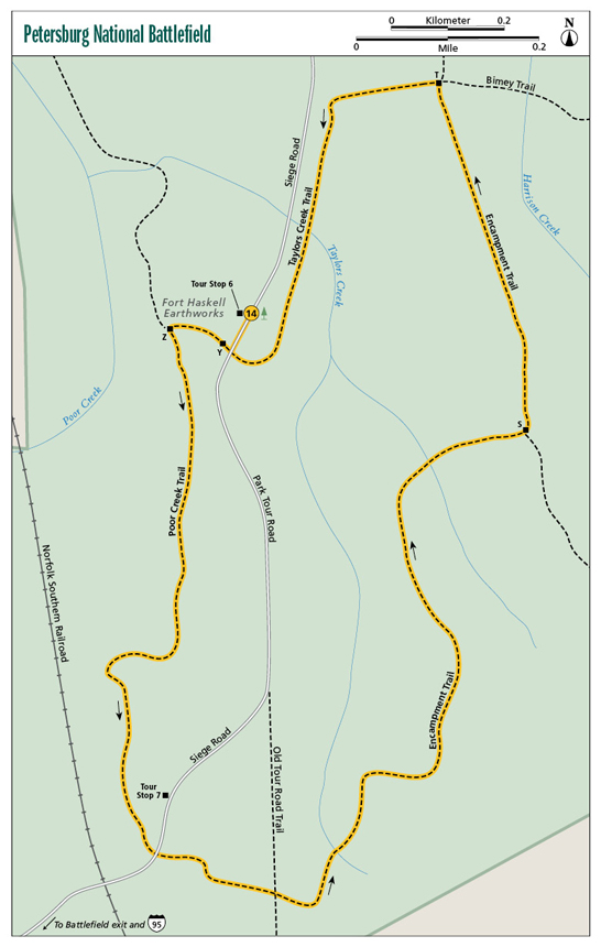
14 Petersburg National Battlefield
This hike loops the Poor Creek drainage of Petersburg National Battlefield, Civil War site of the longest siege in American history. Leave the earthworks of Fort Haskell and travel through bottoms, hills, and by the old Taylor Farm, all of which played roles in the Union blockade of Petersburg. Along the way discover miles of earthworks dug by soldiers during the ten-month blockade. Other hiking trails and the auto tour road provide more exploration opportunities at this large historic and natural site in the heart of Petersburg.
Start: Tour Stop #6 on Park Tour Road
Distance: 2.7-mile loop
Hiking time: About 1.5–2 hours
Difficulty: Moderate
Trail surface: Gravel with some natural-surface path
Best season: Year-round
Other trail users: Bikers, equestrians
Canine compatibility: Leashed dogs permitted
Land status: National park
Fees and permits: Parking fee required
Schedule: Open daily year-round
Maps: Petersburg National Park Eastern Front Trail Map; USGS Prince George
Trail contact: Petersburg National Battlefield, 1539 Hickory Hill Rd., Petersburg, VA 23803; (804) 732-3531; www.nps.gov/pete
Finding the trailhead: From exit 52 on I-95 in Petersburg, take Wythe Street (VA 36) for 2.5 miles to the battlefield. Head to the visitor center, pay your entry fee, obtain a map, then join the Park Tour Road. Follow the Park Tour Road or Siege Road to Tour Stop #6, on your right. Trailhead GPS: N37 13.958' / W77 21.267'
The Hike
The ten-month siege of Petersburg was one of mostly boredom for the soldiers of the Confederacy and the North, but it was interspersed with battles. One such encounter was the Battle of Fort Stedman on March 25, 1865. General Robert E. Lee was determined to pierce Union lines and take Ulysses S. Grant’s military railroad, then concentrate his troops to fight Grant more effectively. The Rebels blasted through the Yankee lines but weren’t able to hold their position, and were pushed back. This hike starts at the earthworks of Fort Haskell, where tightly packed Bluecoats repulsed the Confederate charge. From this point, you head south to the site of the Taylor Farm, where but a brick foundation remains from its Civil War destruction. The loop then wanders amid earthworks still faintly visible under a lush forest.
The trails here at the Eastern Front of Petersburg National Battlefield are well marked and maintained, with intersections marked by concrete posts with an accompanying letter. The entire loop is open to hikers, bikers, and equestrians. Much of the loop is singletrack path. The woods and fields the trail travels are favorable for deer and wild turkey.
Walk over to the earthworks at Fort Haskell, just across from Tour Stop #6. This square was the scene of intense hand-to-hand fighting. The open bucolic lawn makes it hard to imagine such happenings today. The first part of the hike uses the Poor Creek Trail, a singletrack path traveling southbound in classic pine-oak-hickory woods, roughly paralleling Park Tour Road on one side and Poor Creek on the other. A keen eye will spot manipulated land, whether it is from the siege or later as farms. Look for level spots, lines of trees, and even aged forest.
The path nears the Norfolk Southern Railroad. Petersburg was a rail hub during the Civil War and was the reason for Grant marking it for takeover. The hike then reaches Tour Stop #7, where the Taylor family plantation, Spring Garden, was left in ruins. You can now see brick foundations of the home, lying in repose atop a quiet grassy knoll, contrasting an earlier violent time. The balance of the loop joins the mostly wooded Encampment Trail, where trenches and earthworks lace a gorgeous forest amid pretty Taylors Creek and its tributaries. Most of the terrain is revegetated, with trees and brush growing amid the trenches and pits, but they are still visible even in the lushness of summer. A final pair of turns on the Taylors Creek Trail brings you back to the trailhead.
During the siege of Petersburg, Clara Barton, the founder of the American Red Cross, served as superintendent of nurses for the Union.
Miles and Directions
0.0Start by leaving Tour Stop #6. Walk across the road to visit the earthworks of Fort Haskell. Then walk south down Park Tour Road to reach a trail and post Y. Head back into the woods after passing alongside the earthworks. Walk just a short distance to reach post Z and the Poor Creek Trail. Head left on the Poor Creek Trail, joining a southbound singletrack path.
0.5The Poor Creek Trail curves west, nearing fields.
0.7The Poor Creek Trail comes within sight of the Norfolk Southern Railroad, then pops out onto a field, aiming for Tour Stop #7. The railroad lines were the prize for the Union.
0.8Come near Tour Stop #7. Atop the hill to the north stands the brick foundation of the Taylor home. Their farm was destroyed during the war. Cross Park Tour Road and stay left on gravel doubletrack, beginning the Encampment Trail as it heads east. This area, true to its name, was the site of Confederate lines, stretched out in defense, camped for months during the siege. Relic linear earthworks and circular dug pits are visible in the woods and along the trail.
1.0The Encampment Trail turns north and dips into Taylors Creek, a tributary of Poor Creek.
1.2Hickory Trail leaves right for the park ranger station. Stay with the Encampment Trail. The rich, tranquil woods belie yesteryear’s battle and today’s encirclement by the urbanity of Petersburg.
1.6Intersect the Wilcox Trail. It leads left to cross Taylors Creek then return to Tour Stop #6, officially shortcutting this loop. Stay right with the Encampment Trail.
1.7Dip to span a tributary of Taylors Creek. Pass more earthworks.
1.8Reach post S. Here, continue the Encampment Trail left, joining a wide old roadbed, while a spur trail leads right for a horse-trailer parking area near park headquarters. Holly trees are prevalent under a tall overstory.
2.2Reach post T and a four-way intersection, just after passing through a gas line clearing. Turn left, westbound, now on the Taylors Creek Trail, cutting back across the gas line clearing.
2.3Come just a few feet from Park Tour Road. Turn left here, southbound, running parallel to the road.
2.4Bridge sandy but small Taylors Creek. Shortly pass the parking area for Tour Stop #6 and this hike. To make the full hike, keep straight on the Taylor’s Creek Trail. Ahead, pass the other end of the Wilcox Trail just before curving right to meet Park Tour Road.
2.7Reach Tour Stop #6 after backtracking up Park Tour Road, ending the hike.
Petersburg Battlefield Bonus Hike
Other trails lace the Petersburg National Battlefield. An additional enlightening hike makes a 3.4-mile moderate loop, with a few hills. The now-wooded lands present a natural respite contrasting with the dark Civil War days. Start at a replicated siege site, then walk along Harrison Creek, an important battle line during the Petersburg siege. Traverse other historic roads used back then.
Park at Tour Road stop #3. This tour stop details soldier life and siege tactics from the Civil War. Hike doubletrack paths, passing alongside Harrison’s Creek. This quiet stream slips through shady woodland, giving no hint of its importance as a battle line where Union and Confederate soldiers faced one another. Beyond Harrison’s Creek the trail joins old Meade Station Road, an important army provision route during the siege. Finally, the hike loops back on the historic Prince George Court House Road.
The rolling terrain is canopied with hardwoods, cedars, and pines. The park service manages the forest using prescribed fire and you may see evidence of this, especially along the Battery 7 Trail.
With your back to the Tour Stop #3 parking area, take the wide trail heading south on the Attack Road Trail. At 0.2 mile, intersect the Water Line Trail and keep forward to reach post B and a three-way intersection. Turn right here on the Harrison’s Creek Trail. At 0.9 mile reach post R. Stay with the Harrison’s Creek Trail past post Q, now on a singletrack path meandering through piney woods.
At 1.3 miles cross the Park Tour Road and reach Tour Stop #4. Harrison’s Creek is to your left. Keep along Harrison’s Creek and reach post N, then post M, and join the Friend Trail. Turn right, climbing away from Harrison’s Creek. At 1.9 miles cross a tributary of Harrison’s Creek. At 2.0 miles climb to make post L and the Park Tour Road. Keep straight, joining the Battery 7 Trail. Travel level lands. At 2.7 miles reach Post I. Turn right and head due south on Meade Station Trail. This path follows the supply line used by Union soldiers during the siege. At 2.9 miles reach post G. Stay with the Meade Station Trail. At 3.1 miles reach post E to meet Prince George Court House Trail, which was used by both armies to haul men and supplies. Turn right, joining the old road-turned-path. Reach post D, keep straight on the Prince George Court House Trail. At 3.4 miles return to Tour Stop #3, completing the bonus hike.

A replica of an earthworks defense as built by Civil War soldiers