The once hot Elizabeth Furnace is now grown over with brush.
18 Elizabeth Furnace
This Elizabeth Furnace Recreation Area has two interconnected nature trails that present a splendid overview of charcoal production and iron making in 1800s Virginia, all in a gorgeous setting along Passage Creek, nestled between Massanutten Mountain and Green Mountain near Strasburg. The short walk is long on interpretive information and you will get to see the iron-furnace remains up close, as well as a cabin from the 1830s. Plan on adding picnicking, trout fishing, and car camping to your historic hiking agenda—it is all here at Elizabeth Furnace.
Start: Elizabeth Furnace Picnic Area
Distance: 0.9-mile loop
Hiking time: About 1–1.5 hours
Difficulty: Easy
Trail surface: Natural
Best season: Year-round
Other trail users: None
Canine compatibility: Leashed dogs permitted
Land status: National forest
Fees and permits: None
Schedule: 24/7/365
Maps: National Geographic Map #791, Massanutten and Great North Mountain, George Washington and Jefferson National Forests; USGS Strasburg
Trail contact: George Washington National Forest, 95 Railroad Ave., Edinburg, VA 22824; (540) 984-4101; www.fs.usda.gov/gwj
Finding the trailhead: From exit 6 on I-66 near Front Royal, take US 522 south/US 340 south for 1.5 miles, then turn right on VA 155 west. Follow VA 155 west for 5.1 miles to turn left on VA 678, Fort Valley Road. Follow VA 678 for 3.9 miles to turn left into the Elizabeth Furnace Day-Use Area and Picnic Ground. Follow the access road across Passage Creek, then dead-end in a large parking area. The hike starts in the middle of the parking area on the east side. Trailhead GPS: N38 55.736' / W78 19.617'
The Hike
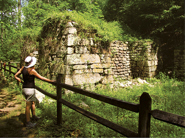
Back in 1836, when this area was the back of beyond, the flats along Passage Creek were home to Elizabeth Furnace, originally known as Fort Furnace. These iron furnaces, essentially giant ovens made of stone, needed four things: stone, iron ore, rich forests, and water. The stone was needed to build the furnace. The iron ore was needed to make the final product, and the forest was needed to make charcoal to fire the iron furnace. Water was needed to power the giant bellows used to raise temperatures inside the furnace to a point where iron could be made.
The valley of Passage Creek had all four. First, the furnace was built from cut stone along Passage Creek, in a spot backed by a hill in order to access the top of the furnace. Then, a water diversion was dug from Passage Creek to power a water wheel that in turn powered the giant bellows. The forests grew rich and magnificent in the Passage Creek valley.
Digging out and hauling the iron ore to the furnace was no easy task. The forests were cut, the wood turned into charcoal, and the charcoal mixed with the iron ore as well as limestone. Men known as fillers dumped what was called charge (iron ore, charcoal, and limestone) into the top of the furnace. Elizabeth Furnace was 33 feet high. A landing platform stretched from the top of the furnace to the hill beside the furnace, allowing the fillers to place the material in the furnace. The uppermost part of the furnace you see today has tumbled over.
After the charge was properly heated, furnace tenders opened the base of the furnace, allowing the iron to flow into molds. These molds were known as pigs, which is how the name “pig iron” came to be.
The once hot Elizabeth Furnace is now grown over with brush.
With many people needed to operate the furnace and all the processes involved, a whole community sprang up around Elizabeth Furnace. Today, you can see a log cabin reconstructed of wood left over from that day by the Civilian Conservation Corps (CCC) in 1936. The cabin is accessible by a footbridge from the trailhead parking area. It is located near the Elizabeth Furnace Campground.
From Elizabeth Furnace the iron molds were hauled on wagons pulled by oxen. They were taken over Massanutten Mountain via a road that is now the Tuscarora Trail, through Shawl Gap, then down to the South Fork of the Shenandoah River. From there, it was loaded onto barges and ships to Harpers Ferry, which was then part of Virginia. During the Civil War this iron was an important part of the Confederate war effort. At that time the iron was hauled to Staunton, Virginia, then taken by railroad to Lexington, and then floated down the James River to the Tredegar Foundry in Richmond.
In 1864 the Yankees destroyed Elizabeth Furnace. It was rebuilt in 1883 but was only in operation for five years before being abandoned for good due to low output and nonprofitability.
The area was in rough shape when the US Forest Service obtained Elizabeth Furnace and the surrounding valley and mountains. The hillsides had been cut over, and Passage Creek was choked with silt from mining and charcoal making. Trees were planted and Passage Creek was restored to its original channels. The CCC then constructed the picnic area and campground, though both have seen several makeovers through the decades.
The trails explaining charcoal making and iron making at Elizabeth Furnace have undergone a few changes too. You will note interpretive signage from different times. The hike as a whole is rewarding. First, you will visit the site of a charcoal pit, then a hillside where the remains of an ore mine stand. The hike then leads to the actual Elizabeth Furnace, where you can see the remnants of the furnace from the top and the bottom. I strongly recommend including a picnic, swim, and a camping trip along with your hike. I have camped here myself and give it a ringing endorsement. In addition, a well-developed trail system emanates from the greater Elizabeth Furnace area, adding plenty of hiking opportunities beyond this nature trail. Finally, be sure to visit the log cabin across the creek from the parking area.
 The property around Elizabeth Furnace was acquired by the US Forest Service in 1913.

Miles and Directions
0.0Start by taking the trail leaving east from the middle of the parking area. It soon opens onto a small field. From here, go left and follow a wooded path to a trail intersection with two large signs, after passing a shortcut trail back to the parking lot. Here, turn right on the Passage Creek Forest Trail, also known as the Charcoal Trail.
0.2Pass the level site of a charcoal pit. Enjoy interpretive signage about making charcoal.
0.3Turn left (north) on the mountain slope.
0.5Pass the iron ore mine site. Descend.
0.6Meet the Iron Ore Trail. Turn right, shortly meeting the furnace bank where fillers accessed the top of the furnace via elevated platform.
0.7A blue-blazed path, the Tuscarora Trail, leaves right and heads to Shawl Gap on Massanutten Mountain. Shortly reach Elizabeth Furnace. Check out the stone structure and attendant relics.
0.8An orange-blazed trail leaves right to access the Signal Knob trail system on the north side of Fort Valley Road.
0.9Arrive back at the large parking area, completing the walk.