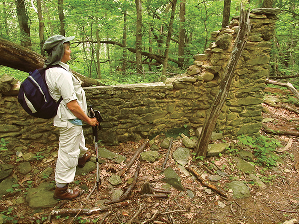
A stone wall marks the old Pocosin Mission.
25 Pocosin Mission
This short ramble off Skyline Drive first takes you past a mountain cabin, then down to a gap and the remains of an Episcopalian mission. Here you can visit what remains of the mission’s wooden living quarters and the stone church. It was from this highland pass where the folk of the mission branched out, working with the local mountaineers on eternal questions.
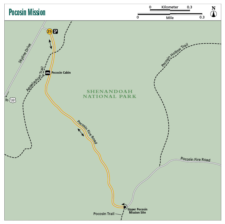
Start: Parking area near The Oaks Overlook on Skyline Drive
Distance: 2.0 miles out and back
Hiking time: About 1.5–2.5 hours
Difficulty: Easy
Trail surface: Natural
Best season: Year-round
Other trail users: None
Canine compatibility: Leashed pets only
Land status: National park
Fees and permits: Entrance fee required
Schedule: 24/7/365
Maps: Shenandoah National Park; USGS Fletcher
Trail contact: Shenandoah National Park, 3655 Highway 211 E., Luray, VA 22835; (540) 999-3500; www.nps.gov/shen
Finding the trailhead: From the intersection of US 33 and Skyline Drive at Swift Run Gap, drive north on Skyline Drive for 6 miles to milepost 59.5. Look on your right for a road and a sign that reads Do Not Block Fire Road. Turn onto this road and park in one of the gravel spots. The Pocosin Fire Road starts here. This parking area is 0.4 mile south of The Oaks Overlook and 1.6 miles north of Bald Face Mountain Overlook. Trailhead GPS: N38 24.795' / W78 29.312'
The Hike
This is a short and easy hike at Shenandoah National Park, doable by the whole family. Leave Skyline Drive on the wide and easy Pocosin Fire Road (closed to public vehicles) and explore the ruins of the Pocosin Mission, where a brave Episcopal minister attempted to save the souls of surrounding mountaineers. Explore the ruins of the mission and other nearby signs of habitation, including a cemetery. If you want to expand your hike, head down Pocosin Hollow, passing many old-growth trees on your way down to a tumbling watercourse, where you’ll find a nice spot to picnic or relax. Alternatively, you can take a stroll on an adjacent parcel of the Appalachian Trail (AT) to enjoy a view from a rocky slope.
Chances are you are going to drive by the hard-to-find trailhead—most people do—but a simple turnaround at an overlook will have you back on track. The entrance to the parking area is narrow and it seems to sneak up on you.
In 1904 the mountains that became Shenandoah National Park were a backwater, a place civilization had passed by, left in the relentless pursuit of America’s westward-looking manifest destiny. A young Episcopalian minister saw an opportunity among these hill folk to convert souls to Jesus. He set up shop in a highland gap just east of the Blue Ridge. He named the mission Upper Pocosin. The area was called the “Dark Pocosin” before his arrival. That oughta give you an idea of what this locale, bordered by Lewis Mountain to the north and Bald Face Mountain to the south, was like.
Now, if a survey had gone around among the people of Dark Pocosin, most would have said they were Christians, however, they weren’t excited about having a preacher coming in. See, in those times, devout Christians were on the front lines of a temperance movement sweeping the country, and there were more than a few backwoodsmen making and/or drinking moonshine. The locals thought the missionary might look less than kindly on their actions, perhaps even turn them in to the law.
Some of the locals decided to scare the minister off. They made threats against his life, making sure their intentions made it to the minister’s ears. The mission suffered a setback when carpenters hired to build the initial facility—a chapel that would double as a schoolhouse—were intimidated into quitting their jobs despite the scarcity of work in these Potomac Highlands.
However, instead of running off, the minister confronted one of the ringleaders. The minister came to the door of the mountain cabin and knocked. When the ringleader opened the door, the minister introduced himself and said, “I hear you want to kill me.” The mountaineer couldn’t help but admire such courage. Slowly the area residents were won over.
A stone wall marks the old Pocosin Mission.
The minister began having Sunday sermons, and attendance grew. Later he added a barn and a smaller building where donated clothing was sold for cheap, a sort of thrift store that helped the locals purchase inexpensive clothing while the revenue helped run Pocosin Mission.
Later, a modest stone church was built. You can see the remains of it today. The mission did have an effect on the local people. Rowdiness, drinking, and fighting declined. Church attendance rose. They applied the lessons they learned. Upper Pocosin Mission became a community center of sorts, with area residents gathering for music, games, and ministry. Out-of-town volunteers would come and help at the mission, staying for a month or so at a time. The mission remained in operation until Shenandoah National Park came to be. As the reality of being evicted from their homes set in, mission workers introduced the locals to the outside world, taking them on trips to the city and mentally preparing them to leave their historic family lands.
Today, Upper Pocosin stands silent, crumbling a little more every season, covered more and more by the ceaseless growth around it. The same goes for the cabins, fields, and roads of the people who once were affected by the mission. Time waits for no one.
The hike to the mission site is an easy one. Once at the gap and trail intersection at Upper Pocosin, follow the footpath to the steps of the old church. View the walls made of native stone. The other nearby building is barely standing. I believe this is the mission workers’ cabin. Parts of the structure were built with hand-hewn logs; boards, nails, and even tarpaper were later additions. At your feet there is much broken glass, parcels of clay pipe, and even crockery shards. Look around for the cemetery, where a few graves are marked with simple stones.
As you tour the area, imagine the work of these missionaries, spreading Christianity among locals who had rarely traveled more than a day’s horseback ride from their places of birth.
If this hike seems too short, take a side trip down Pocosin Hollow. To get there, continue down the Pocosin Fire Road and veer left on the Pocosin Hollow Trail after a quarter mile. From this point forward, you should have the path to yourself. Look for large old-growth trees scattered here and there along the path. The hike passes a boulder field before entering a wet-draw. This is a rich wildflower area in spring. Numerous old-growth yellow birch, oak, and tulip trees rise overhead. Come to the main watercourse of Pocosin Hollow, a tributary of the Conway River, 1.8 miles from the mission. A rock-hop will take you to the far side of the stream and a nice resting spot.
Another option is to take the AT from the intersection with Pocosin Fire Road southbound to a decent view. You will travel through rocky woods on a singletrack path. Pass a side trail to the Potomac Appalachian Trail Club cabin. Climb rocky steps, winding through boulders on a beautifully built trail leading to an outcrop with an easterly view. The view requires about a quarter-mile walk from the Pocosin Fire Road.
 The Breeden family once had a cabin and small farm where the PATC Pocosin cabin now stands. Members of the Breeden family briefly stayed at Pocosin Mission after their farm was purchased by eminent domain.
Miles and Directions
0.0Leave the parking area on the Pocosin Fire Road, passing around a chain gate on a nearly level wide grade. A northern hardwood forest of red maple, sugar maple, basswood, and cherry rises overhead. Distinguishing between sugar maples and red maples is easy. Look at the leaf of a sugar maple. The curves between lobes of the sugar maple are U shaped, whereas the curves between lobes of the red maple are at right angles.
0.1Intersect the AT. Keep straight on the Pocosin Fire Road.
0.2Come to a clearing. This is the Pocosin Cabin, built in 1937 by the Civilian Conservation Corps, and the site of the Breeden cabin. The Potomac Appalachian Trail Club (PATC) rents this cabin out. However, you must be a member of the PATC to rent it. Soon pass a spring on the left. It is used by AT hikers and those staying at Pocosin Cabin.
1.0Come to a trail junction. This spot is known as Upper Pocosin. To your right through the trees are the remains of the Pocosin Mission. Pocosin Fire Road continues to the left and links this area with the Pocosin Hollow Trail, while the Pocosin Trail leaves right. Backtrack after leaving the mission or expand your trek on one of the recommended additional trails.
2.0Arrive back at the trailhead, completing the hike.