Upper Doyles Falls
26 Browns Gap
This loop features both Virginia history and natural beauty. Start at Browns Gap, site of significant Civil War activity, especially by Confederate legend Stonewall Jackson. Head down a 200-year-old turnpike, passing a Rebel’s grave. Leave the historic road and follow Doyles River past two significant waterfalls. Climb up Jones Run, viewing several old-growth trees, and see one more big cataract. Finally, complete the loop by passing by Dundo Picnic Area, once a Civilian Conservation Corps Camp, while Shenandoah National Park was being developed.
Start: Browns Gap on Skyline Drive
Distance: 6.9-mile loop
Hiking time: About 3.5–5 hours
Difficulty: Difficult due to elevation change of 1,250 feet
Trail surface: Natural
Best season: Year-round
Other trail users: None
Canine compatibility: Leashed pets only
Land status: National park
Fees and permits: Entrance fee required
Schedule: 24/7/365
Maps: Shenandoah National Park; USGS Browns Cove
Trail contact: Shenandoah National Park, 3655 Highway 211 E., Luray, VA 22835; (540) 999-3500; www.nps.gov/shen
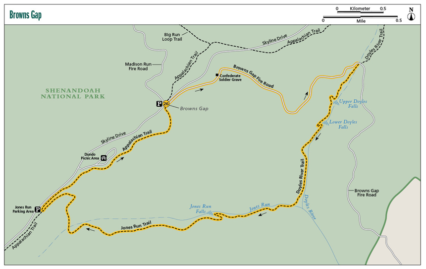
Finding the trailhead: The hike starts at the Browns Gap parking area, milepost 83.0 on Skyline Drive in Shenandoah National Park. From the Rockfish Gap entrance station at the intersection with exit 99 on I-64, take Skyline Drive north for 21.6 miles to the trailhead, on your left. Trailhead GPS: N38 14.425' / W78 42.633'
The Hike
In addition to the history of Browns Gap, this loop hike visits three significant waterfalls and numerous other cascades while visiting two boulder-strewn canyons. The Appalachian Trail (AT) forms the final link to complete the circuit. Both Jones Run and Doyles River feature scattered old-growth hardwoods.
Browns Gap, where this hike begins, is significant as a mountain pass connecting the Shenandoah Valley to the west and the Piedmont to the east. Construction began on this turnpike in 1805. Two fellows, one from east of the Blue Ridge named Brightberry Brown and one from west of the Blue Ridge named William Jarman, began simultaneously working on this road. They met at the top of the Blue Ridge, here at Browns Gap. Legend has it that the two construction crews had a big brawl, each side bragging it had done a better job building the road.
Upper Doyles Falls
Controversy continued. The folks west of the Blue Ridge called it Madison Run Turnpike, while east of the Blue Ridge it was called Browns Gap Turnpike. Even today, the park service gives this two-century-old road different names. Speaking of that, when the road was closed in the 1930s, residents of Grottoes and points west grumbled mightily as they had to take a more roundabout route to access Charlottesville.
The turnpike gained importance as a commercial connector and later had significance in the Civil War. In May of 1862 Stonewall Jackson passed through Browns Gap, then went on down to Charlottesville. But his forces’ movements were a trick. Jackson loaded his men onto a railroad and headed back west across the Blue Ridge, defeating the Yankees near Staunton. Stonewall continued on his monthlong brilliant and well-studied Valley Campaign, where he defeated the North five times consecutively. Stonewall then returned to Browns Gap, resting his men for a week and building breastworks to cover the gap. Very little remains of the Confederate fortifications. Some Civil War scholars argue the breastworks were built in September of 1864 by Jubal Early, another Confederate leader.
The last part of the hike leads past Dundo Picnic Area. It was not always the grounds you see today, a mixture of trees and grass with scattered picnic tables, water spigots, and a restroom. Back in the mid-1930s, as Shenandoah National Park was being developed, the area was home to a Civilian Conservation Corps camp. Back then, the young men lived in hundred-foot-long barracks and dined at a large mess hall. Beside this, there were administration and office buildings, as well as a garage and clinic. Times sure have changed here at Browns Gap.
 Civilian Conservation Corps recruits, like those housed in what is now Dundo Picnic Area, were paid $30 per month, $25 of which went home to their families.
Miles and Directions
0.0Leave the Browns Gap parking area and cross Skyline Drive. Immediately begin descending on the Browns Gap Fire Road. Madison Run Fire Road leaves west from the gap near the parking area.
0.4Look for a small path leaving the road. Walk a few feet up this narrow path to the grave of William H. Howard, Confederate States of America soldier. The carved stone slab marks his interment locale. Continue down the fire road on a gentle grade. Pass through an attractive stand of pines. Views open through the trees toward the Piedmont.
0.9On your left a brushy area contains relics indicating former human habitation, such as piled rocks. Imagine the forest as cleared and cultivated at this homesite.
1.7Cross an iron bridge spanning the Doyles River. Reach a trail junction. Turn right onto Doyles River Trail, leaving the historic turnpike as it heads on for Browns Cove. The hike will be busier from here to the falls. Other hikers will have come from the Doyles River trailhead.
1.9Cross the Doyles River, a normally easy rock-hop. Doyles River Trail continues along the watercourse but swings away as it approaches Upper Doyles Falls.
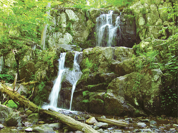
2.1Come to a side trail leading to Upper Doyles Falls. Here, the three-tiered, 30-foot cascade spills into a bouldery glen where a tributary feeds the river. Doyles River repeatedly spills downcanyon in unnamed cascades.
2.4Reach the base of Lower Doyles Falls at a sharp switchback. Lower Doyles Falls is steeper and showier, falling 63 feet. It propels over a rock lip, then pours in streamers and threads over multiple tiers to finally slow in a pool before charging on. The cataract will appear different depending on water levels. A stone face extends across the far gorge.
2.7The trail squeezes down the narrow, very rugged gorge, and crosses a falling tributary on a wooden bridge. Continue downriver.
2.9Meet the ideal summertime swimming hole, dark and still between rapids.
3.1Reach a concrete trail marker and the end of the Doyles River Trail. Jones Run and Doyles River flow together below. Stay with the hikeway as it changes names from Doyles River Trail to Jones Run Trail.
3.3Rock-hop Jones Run. Watch for old-growth tulip trees with enough diameter that several hikers would be needed to encircle them. Above, large boulders litter the canyon. Keep ascending, watching for long slide cascades.
3.8Step over a tributary, climb a bit more, then arrive at Jones Run Falls. Here, the stream tumbles 45 feet over a solid rock face. Inviting streamside rock slabs make for ideal viewing and relaxing spots. The trail turns sharply left, circling around the rock face forming the falls. Pass the top of the falls and continue along Jones Run, viewing more tumbling water.
5.0Join an old wagon road. The no-longer-maintained part of the wagon road once went to Via Gap (see sidebar page 142).
5.2Step over what is left of Jones Run. Leave the wagon track, also heading for Browns Gap.
5.4The Jones Run Trail makes a sharp left turn.
5.7Meet the Appalachian Trail. The Jones Run trailhead and parking area are a few steps away. Turn right on the AT, northbound, toward Dundo Picnic Area.
6.3Pass spur trails to Dundo Picnic Area. Keep straight among oaks, laurel, and pines.
6.9Arrive at Browns Gap after descending, and complete the hike.