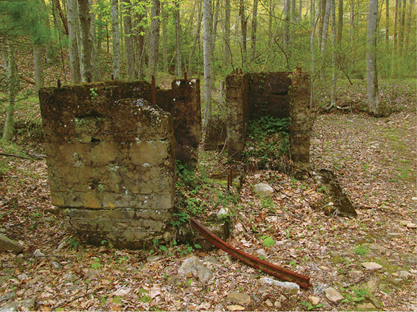
Remains of an old iron ore processing locale
28 Saint Marys Wilderness
This historic hike drops off the Blue Ridge Parkway to explore an old mine site, now reverted to nature, as part of the Saint Marys Wilderness, within the confines of the George Washington National Forest. From the highlands, you will pass along Mine Bank Creek, which boasts numerous splashing waterfalls and cascades. Open into the Saint Marys River valley, then head to a riverside ore-processing locale, where concrete remnants and grown-over slag piles reveal an industrial past that belies the splendor of the Saint Marys Wilderness.
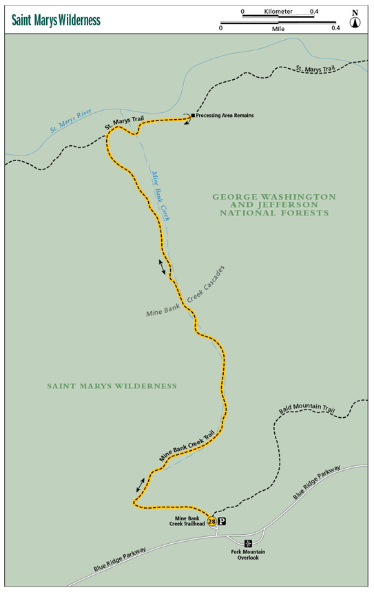
Start: Mine Bank Creek Trailhead off milepost 23.1 of the Blue Ridge Parkway
Distance: 4.6 miles out and back
Hiking time: 2.5–3.5 hours
Difficulty: Moderate, does have 1,150-foot descent
Trail surface: Natural
Best season: Year-round
Other trail users: None
Canine compatibility: Leashed dogs permitted
Land status: Wilderness area within national forest
Fees and permits: None
Schedule: 24/7/365
Maps: National Geographic Map #789, Lexington/Blue Ridge Mountains, George Washington and Jefferson National Forests; USGS Big Levels
Trail contact: George Washington National Forest, 27 Ranger Ln., Natural Bridge Station, VA 24579; (540) 291-2188; www.fs.fed.us
Finding the trailhead: From exit 205 on I-81/I-64, take VA 606 east for 1.5 miles to Steeles Tavern and US 11. Turn left on US 11 north for 0.1 mile, then turn right on VA 56 east. Follow VA 56 east for 5.4 miles to the Blue Ridge Parkway. Join the Blue Ridge Parkway northbound and follow it for 4.1 miles to the Mine Bank Trailhead on your left, just before reaching the more easily identifiable Fork Mountain Overlook, which will be on your right. Trailhead GPS: N37 54.721' / W79 5.214'
The Hike
This hike combines Virginia’s mountain beauty with history. The setting is the Saint Marys Wilderness, a 10,000-acre parcel of the George Washington National Forest, designated by the US Congress. Though its wilderness designation has been in place for decades and the woods have literally gone back to the deer and bears, the Saint Marys River watershed has had a long history of development. The old-growth forests that once cloaked this gorgeous mountain gorge were first harvested for fuel wood, bark for tanning hides, and for construction timber used in the Shenandoah Valley. Other, larger logging operations followed. Later, the valley was mined for iron ore and manganese by the Pulaski Iron Company. They ran a railroad spur from the Shenandoah Valley up the Saint Marys River to its confluence with Chimney Branch. A series of mine openings as well as processing areas sprang up in the Saint Marys Gorge. The mining period started in 1910 and really ramped up during World War I, then tapered off, and finally phased out in the 1950s. Among the 20 or so miles of trails, hikers can find locales where mining, processing, and transporting the ore took place.
This particular hike heads to a processing area near the confluence of Mine Bank Branch and the Saint Marys River. It starts on the Blue Ridge Parkway, which offers the best and safest wilderness access, particularly if you are camping overnight in the gorge. The lowermost trailhead on St. Marys Road has suffered from auto break-ins in the past. I wouldn’t leave my car there overnight, therefore I won’t recommend it for you. Furthermore, the trail leaving from there has been washed out and compromised by floods over the years. It can be very rough in places, yet it is heavily used because it offers the quickest access to Saint Marys Falls.
Remains of an old iron ore processing locale
Our hike leaves the Mine Bank Creek Trailhead, atop the Blue Ridge on the south side of the Saint Marys Gorge. It soon drops off the ridge crest and enters the Mine Bank Creek valley, a heavily wooded and scenic watershed full of waterfalls. These waterfalls are at their boldest from late winter through spring and can slow to a mere trickle in fall. In spring the valley will be rife with wildflowers, from pink-hued white trilliums to bleeding hearts and more. Massive boulders and rock ramparts are scattered throughout the valley. Along the way down you will spot a rough roadbed. The trail will follow this. Ore was transported down this route to a processing area near the Saint Marys River. It is hard to imagine moving ore through this rugged terrain.
The Mine Bank Creek Valley finally opens up, easing the almost endless falling water. The Saint Marys River Gorge seems wide open in comparison. You head up the Saint Marys River and it isn’t long before reaching a mine site and processing area in a flat nestled between the Saint Marys River and a nameless tributary. You will see the timeworn concrete walls of a processing area, metal relics, and fairyland-looking slag piles, grown over with grass and trees. This is a fun place to explore. Visit the mine area, the campsites, and the river. There are no deep mine shafts to fear.
If you have some extra energy, consider heading down to Saint Marys Falls. To reach the falls, hike downriver on the Saint Marys Trail, passing other mine sites and making your way over a ridge, before descending into cascade-rich Sugartree Branch. From there, hike the spur trail to Saint Marys Falls. Saint Marys Falls tumble 10 feet over a ledge between quartzite walls deep in the gorge. The large pool at the base is surrounded by jagged boulders and short cliffs. More pools and falls are upstream, but they are a challenge to access. The distance between Saint Marys Falls and the junction of Mine Bank Creek Trail with the Saint Marys Trail is about 2 miles one-way.
 The Saint Marys Gorge was designated a wilderness by Congress in 1984.
Miles and Directions
0.0As you are facing the Mine Bank Creek Trailhead kiosk, you will see a gated forest road to your left and a faint woods road to your right. In between the two is a singletrack foot trail that starts near the gated forest road. This is the Mine Bank Creek Trail. Follow the Mine Bank Creek Trail north, entering the Saint Marys Wilderness and shortly intersecting the Bald Mountain Trail. Stay left with the Mine Bank Creek Trail.
0.3After walking through pines, mountain laurel, and oaks, make a big turn to the right and descend into the Mine Bank Creek valley.
0.5Step over Mine Bank Creek for the first time. The stream may be dry in fall at this elevation. Rhododendron, black birch, and yellow birch rise in the cooler, moister valley.
0.8Hop Mine Bank Creek a second time, dropping deeper into the bouldery vale.
0.9Cross Mine Bank Creek again, this time just above a waterfall that makes a series of stair-step cascades.
1.0Cross over to the right-hand bank of Mine Bank Creek.
1.1Cross over to the left-hand bank of Mine Bank Creek. Soon step over a tributary, adding flow. Big bluffs rise on both sides of the valley. The path becomes rockier.
1.3Come to Mine Bank Creek Cascades. This fall spills about 60 feet over an angled slide. More waterfalls drop downstream. Begin to follow a stony but cleared tram road once used to haul ore. The creek and road separate.
1.9Intersect the Saint Marys Trail after the Mine Bank Creek valley perceptibly widens. For this historic hike, turn right, heading up the Saint Marys River (Go the other way to access Saint Marys Falls).
2.1Cross Mine Bank Creek for the final time. Wander through relatively level forest, passing campsites.
2.3The trail crosses an unnamed tributary of the Saint Marys River. Just across the tributary stand concrete relics of an ore-processing area. Look around for grown-over slag piles, iron rails, and other evidence. The whole area is worth exploring. Backtrack when finished.
4.6Arrive back at the Blue Ridge Parkway and the Mine Bank Creek Trailhead.