 The defunct mining town of Fayerdale was named using parts of two mine owners’ names, the “F” and “A” for Frank A. Hill and “Dale” for Herbert Dale Lafferty.
32 Stuarts Knob at Fairy Stone State Park
This hike at Fairy Stone State Park explores the historic and natural features of Stuarts Knob, rich with iron ore. Starting in the 1700s, this backwater experienced mining boom and bust, becoming a moonshiner’s paradise. Later, the Civilian Conservation Corps (CCC) developed a state park here. Today you can see vestiges of mining operations and an attendant community on CCC-built trails, all encapsulated in hilly wooded terrain enhanced with natural beauty, including a cleared view from the shoulder of Stuarts Knob.
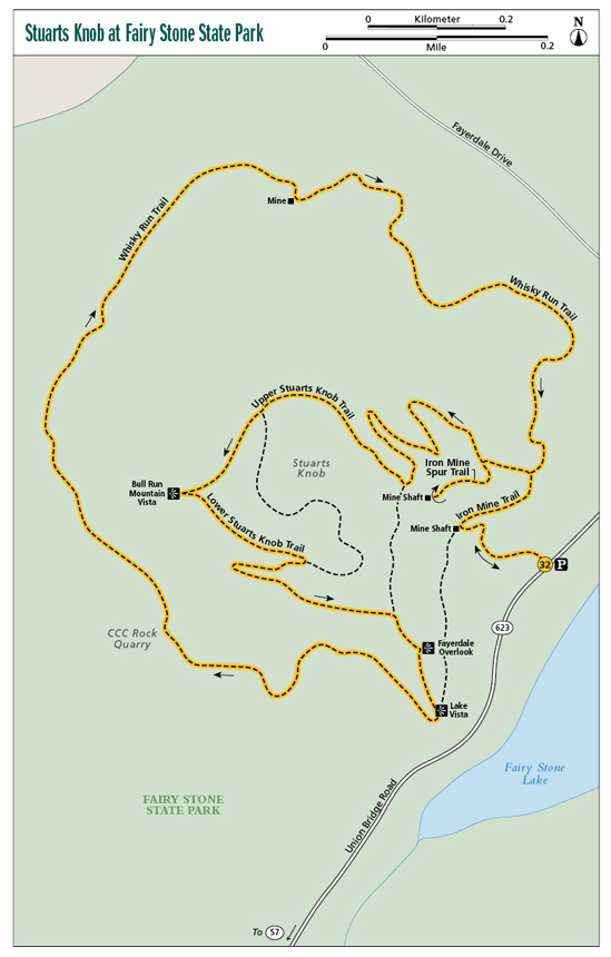
Start: Stuarts Knob Trailhead on Union Bridge Road, VA 623
Distance: 3.2-mile balloon loop
Hiking time: About 2–2.5 hours
Difficulty: Moderate, does have steep hills
Trail surface: Natural-surface path
Best season: Spring for wildflowers
Other trail users: None
Canine compatibility: Leashed dogs permitted
Land status: Virginia state park
Fees and permits: Parking fee required
Schedule: Open daily year-round
Maps: Fairy Stone State Park; USGS Philpott Lake, Charity
Trail contact: Fairy Stone State Park, 967 Fairy Stone Lake Dr., Stuart, VA 24171-9588; (276) 930-2424; virginiastateparks.gov
Finding the trailhead: From the town of Bassett, take VA 57 (Fairy Stone Park Highway) west for 10 miles to VA 346. Turn right on VA 346 (Fairy Stone Lake Road) north and follow it 0.4 mile to VA 623 (Union Bridge Road). Turn left on Union Bridge Road and follow it 0.8 mile to the Stuarts Knob trailhead, on your left just after a boat ramp. Trailhead GPS: N36 47.906' / W80 7.019'
The Hike
How does a state park get a name like Fairy Stone? Within its boundaries lie some unusual crystals, made of iron aluminum and silicate. Due to their six-sided shape, these crystals connect at right angles, often forming crosses. Legend has it that fairies once roamed this land in the shadow of the Blue Ridge. When the fairies learned of Jesus’s death, their tears crystallized when they hit the ground. The fairies have since moved on, but the fairy stones mark the sorrowful spot where they were when Jesus died. These fairy stones were one attraction that led to this locale becoming one of Virginia’s first state parks.
Stuarts Knob is yet another attraction. This mount was found to be rich in iron ore. Starting in the late 1700s, men were mining the mountainsides using simple pick and shovel. The backbreaking work was slow and challenging. Despite the difficulty of moving the product to market, Stuarts Knob was mined this way for over one hundred years until technology made extraction more efficient.
The Virginia Ore and Lumber Company updated operations in the early 1900s. The mining town of Fayerdale sprang up, but the company and the town collapsed upon the arrival of cheaper ore from Germany. Today we can roam the trails of Stuarts Knob and see the mine sites while walking the roads used to access those mines, all contained on the slopes of a scenic wooded hillside that allows views of adjacent mountains and displays the amazing recuperative powers of nature. You will also get a chance to see the works of the Civilian Conservation Corps (CCC). Their marks are everywhere, from the lake you see below Stuarts Knob to the quarry from which they extracted stone to build the facilities still in use today.
The hike is not only historic but scenic too. You will soon rise to view the first of three mine openings, all barred for safety reasons. The hike then scales the slope of Stuarts Knob, where tulip trees regally rise. Reach a view of Bull Run Mountain and other hills of the Blue Ridge in the distance. Next, the CCC-built trails lead to a view of Fairy Stone Lake and the heart of the park facilities. The final part circles the lowermost reaches of the knob, crossing streamlets and even an old moonshine still site. The mining and lumbering had all but ended in the area, leaving the production of “corn likker” a viable and very profitable, though illegal, endeavor, as this was after Prohibition was enacted. Ironically, the CCC boys provided a new market for the moonshine. Later, the railroad and mining equipment was sold off, leaving only an altered landscape and a few relics here and there, protected within an Old Dominion state park.
The defunct mining town of Fayerdale was named using parts of two mine owners’ names, the “F” and “A” for Frank A. Hill and “Dale” for Herbert Dale Lafferty.
Miles and Directions
0.0Start by leaving the Stuarts Knob Trailhead on the Iron Mine Trail, heading uphill among tulip trees, white pine, and red bud.
0.1Reach an intersection. Here, the Iron Mine Trail goes right and left. Walk a few feet left to see the first mine opening, then go right, working on a steep side slope.
0.2Meet the north end of the Whisky Run Trail. You will return here later. For now, stay left on the Iron Mine Trail, working up Stuarts Knob.
0.3Reach the Iron Mine Spur Trail. Take this steep path left up to another mine opening. Note the grown-over tailings near the mine site. Backtrack, then continue the Iron Mine Trail in gorgeous tulip-tree-dominated woods. Ascend the slope of Stuarts Knob by switchback.
0.7Come to another trail junction. Here, the Iron Mine Trail leaves left. Turn right, joining the Upper Stuarts Knob Trail. Curve around the north side of Stuarts Knob, looking for unnatural diggings into the hillsides.
0.9Veer right, picking up the Lower Stuarts Knob Trail.
1.0Take the short spur leading right to the Bull Mountain Overlook. Gain views of Bull Mountain along with hills and valleys between. Continue on Lower Stuarts Knob Trail.
1.1Stay right after rejoining the Upper Stuarts Knob Trail. Switchback downhill on the south side of Stuarts Knob.
1.4Stay right at the intersection with the Iron Mine Trail. Shortly pass the spur left to the Fayerdale Overlook. A diagram shows the town’s layout below.
1.5The Iron Mine Trail takes you to an overlook of Fairy Stone Lake, the swim beach, and facilities beyond. Turn right here, joining the Whisky Run Trail. Curve past pines and mountain laurel on the south-facing slope.
1.8Come to a steep drop-off on your left. You are atop the rock quarry worked by the CCC, which used the stone to develop the park in the 1930s. Don’t try to explore it from here. Keep walking around to the west side of the knob in rocky woods.
2.1Step over a drainage. Curve around to the north side of the knob. The terrain flattens a bit. Begin bisecting small drainages.
2.4The Whisky Run Trail passes the final barred mine site to the right of the trail.
2.6Look for the rocky remains of an old moonshine still just after crossing a branch. An interpretive sign details whisky making in these parts.
3.0The Whisky Run Trail finishes its loop around Stuarts Knob. Turn left here and backtrack to the trailhead.
3.2Reach the trailhead, ending the hike.
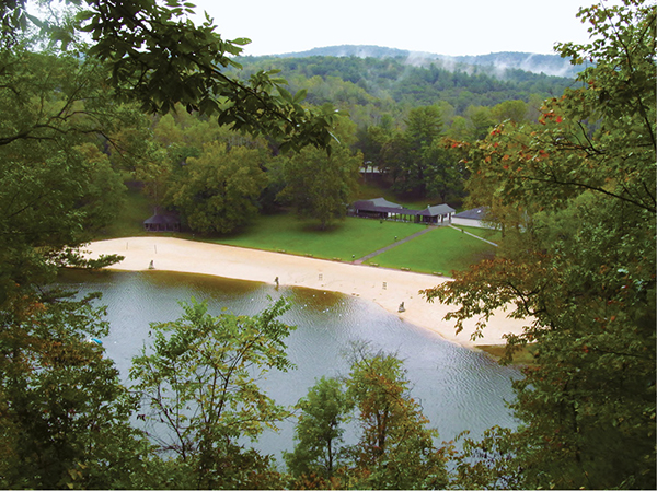
Looking down on the state park beach