
The Shot Tower
33 Shot Tower via New River Trail
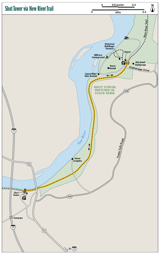
This hike traces a historic converted rail line that leads to a shot tower—used in making lead rifle shot, one of only three such towers in the United States. Start at Foster Falls, a former milling community on the banks of the New River. Tour the assortment of old structures before walking the level New River Trail astride the powerful river of the same name. The old rail line takes you past a river ford used for hundreds of years. Reach the shot tower and take a stroll around it, appreciating the 200-plus-year-old structure before backtracking on the New River Trail to Foster Falls.
Start: Foster Falls
Distance: 3.0 miles out and back, plus touring grounds of Foster Falls
Hiking time: About 1.5–2 hours
Difficulty: Easy
Trail surface: Pea gravel
Best season: Year-round
Other trail users: Bicyclists and equestrians
Canine compatibility: Leashed dogs permitted
Land status: Virginia state park
Fees and permits: Parking permit required
Schedule: Open daily year-round
Maps: National Geographic Mount Rogers; USGS Foster Falls, Sylvatus
Trail contact: New River Trail State Park, 176 Orphanage Dr., Foster Falls, VA 24360; (276) 699-6778; virginiastateparks.gov
Finding the trailhead: From exit 24 on I-77 south of Wytheville, take VA 69 (Lead Mine Road) for 0.2 mile east to US 52. Turn left on US 52 (Fort Chiswell Road) and head north for 1.5 miles to VA 608 (Foster Falls Road). Turn right on 608 and follow it for 1.8 miles to VA 623, Orphanage Drive (do not take the road access to Foster Falls). Turn left on Orphanage Drive and shortly enter Foster Falls, part of New River Trail State Park. Park on the right at the restored railroad station. Trailhead GPS: N36 53.057' / W80 51.365'
The Hike
Foster Falls makes an ideal place to start a hike to Shot Tower, for it contains a history of its own. Foster Falls was a community centered on the large rapids of the New River here. In the early 1880s a millrace was built on the right-hand riverbank. The power of falling water was harnessed to help power an iron furnace, and later a sawmill to cut lumber and a gristmill to grind corn. With the advent of the railroad running along the river, the village of Foster Falls grew to add a store/community center, post office, and hotel! Time passed, the furnace cooled, and the hotel became a school, then an orphanage. By 1962 Foster Falls was a collection of unused buildings and the orphanage had moved to Wytheville.
Since becoming part of New River Trail State Park, the area has undergone a makeover. The historic buildings have been stabilized and restored, including the old train depot, now a gift/information shop. Recreation facilities have been added. Though no one lives here anymore, you can camp at Foster Falls. Read below for more about park activities.
Your hike to Foster Falls follows the old railroad bed of the Norfolk and Western Railroad. New River Trail State Park is Virginia’s longest park, extending over 57 miles along a former railroad bed. Thanks to Norfolk Southern Corporation, the state of Virginia received this railroad right-of-way. Since the tracks were removed by Norfolk Southern, the remaining trail bed was already in usable shape, and it wasn’t long before the New River Trail was being used by recreationalists.
The Shot Tower
The rail trail is the primary attraction of Foster Falls, as it courses along a cinder bed and over trestles that span the New River and its tributaries. There’s even a tunnel. Occasional rapids and riverside bluffs satiate the visual palate. This trail demonstrates how, in our modern era, we can preserve scenic and historic areas in the midst of human habitation.
The building of the Shot Tower was preceded by the discovery of lead, the primary ingredient in shot. Interestingly, at one time Moses Austin, father of Stephen F. Austin of Texas fame, ran the lead mines at nearby Austinville, and lent his name to the town. During the Civil War these lead mines were the chief source of shot for the Confederacy.
Millrace Campground, at Foster Falls, is in excellent condition. Nestled beneath a grove of sycamore and tulip trees, the well-groomed camping area beckons hikers and other park visitors to come back one day and spend the night. As its name implies, the campground is on the banks of the New River, on a carved-out side stream, or millrace, of the New River. The rapids of Foster Falls provide wonderful background music for campers who wish to pitch their tents here. Note: This is a tent-only campground. Furthermore, it is a walk-in tent campground. Campers must transfer their gear from their vehicle to little wagons used to haul gear to their chosen sites. Each camping area has a picnic table, fire grate, and lantern post. Camping is by reservation only. Sites are available most weekdays and on off-season weekends. Call well ahead to reserve a site on summer weekends, since there are only twelve campsites.
There is much to do here including fishing for walleye, bass, and bream and swimming, tubing, or canoeing. A livery offers tubes and canoes for rent, as well as bicycles and shuttle service for heading out on the rail trail. Popular bike runs are from Galax to Foster Falls, or Pulaski to Foster Falls. On summer weekends the equestrian livery is open for business, enabling you to ride the rail trail atop a horse.
 In 1981 the American Society of Mechanical Engineers designated the Shot Tower a National Historic Mechanical Engineering Landmark.
Miles and Directions
0.0Start by leaving from the Foster Falls Depot southbound on the New River Trail. Immediately cross Orphanage Drive. The main facilities of Foster Falls are to your right. Soon pass an old railroad mile-marker post beside the trail. Pass above the bike/tube/canoe livery, gaining excellent river views of the rapids that comprise Foster Falls. Also, note the upper end of the millrace, dug to power industry of Foster Falls.
0.4Travel in sometimes wooded, sometimes open areas. Pass under a large power line. Saddle alongside a quiet stretch of the river.
0.8Pass a cedar-clad high bluff on your left after walking beneath ash, walnut, redbud, and dogwood. The river and trail separate. The flat below is occupied by the Mark E. Hufeisen Horse Complex. The I-77 Bridge crossing the New River is visible in the distance.
1.2The entrance to the horse complex crosses the New River Trail.
1.4Come to the curved trestle over Shorts Creek and US 52.This is the site of Jackson’s Ferry, where a hand-drawn ferry was in operation from 1758 until 1930, when the US 52 bridge was built here. It is only natural that US 52 and I-77 cross the New at this location, as new road systems often follow historic pathways that make the most sense in getting from here to there.
1.5Reach the spur trail leading left and uphill to the Shot Tower. The New River continues straight, ultimately to end at Galax, Virginia, after 26 miles. Head up the spur to explore the Shot Tower and environs, but the inner tower will be closed unless interpretive tours are going on. Backtrack toward Foster Falls.
3.0Arrive at Foster Falls and the old depot, completing the rail trail trek.