Utah
Journal Entry
August 4, 2009
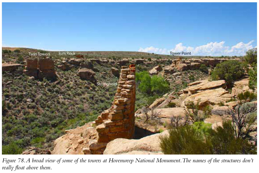
Even in a region where superlatives deservedly apply to so many of the archaeological remains listed in this guide, Hovenweep stands out as a unique—and uniquely marvelous—reflection of the architecture of the native peoples of the American Southwest. Not cliff dwellings or great houses, beginning a bit after AD 1200, the builders of Hovenweep constructed a series of seven major masonry towers along the north and south rims of a small canyon in eastern Utah. They also built two towers within the canyon itself.
About a 1.5-mile hike starts at the visitor center and takes you down into the canyon and then up again to the other side. From there you travel around the rim and get a close view of almost all the ruins, including Hovenweep Castle (large and impressive) and Twin Towers. It’s a very, very cool place. The hike brings you back to the visitor center. Hovenweep is one of the most interesting of the Ancestral Puebloan ruins.
What You Will See
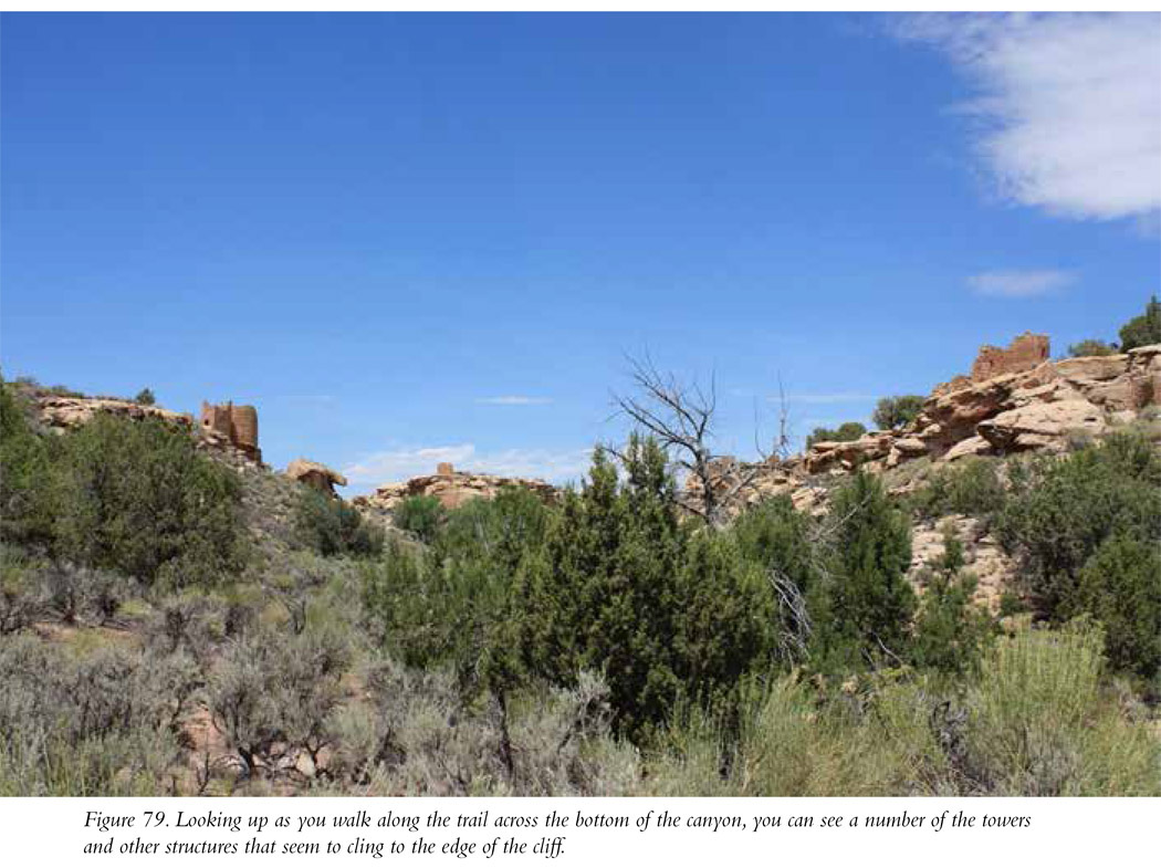
At Hovenweep you’re going to see some very impressive examples of the architectural skill of the native peoples of the American Southwest. From the very informative visitor center, it’s a short 300-yard stroll to the beginning of the Rim Trail that circles Little Ruin Canyon (Figure 78). For most of its 1.5-mile loop, the trail affords a flat and easy, unpaved hiking surface that follows the rim of the canyon (I.20). However, across a short stretch it is a little steeper, descending into the canyon and then climbing back out (Figure 79). There’s also a short (0.5-mile) loop off the main trail to Tower Point. If you take the main trail as well as the Tower Point Loop, it’s about a 90-minute hike. With stopping for photos, figure it can take as little as a couple of hours, though you might want to spend more time there.
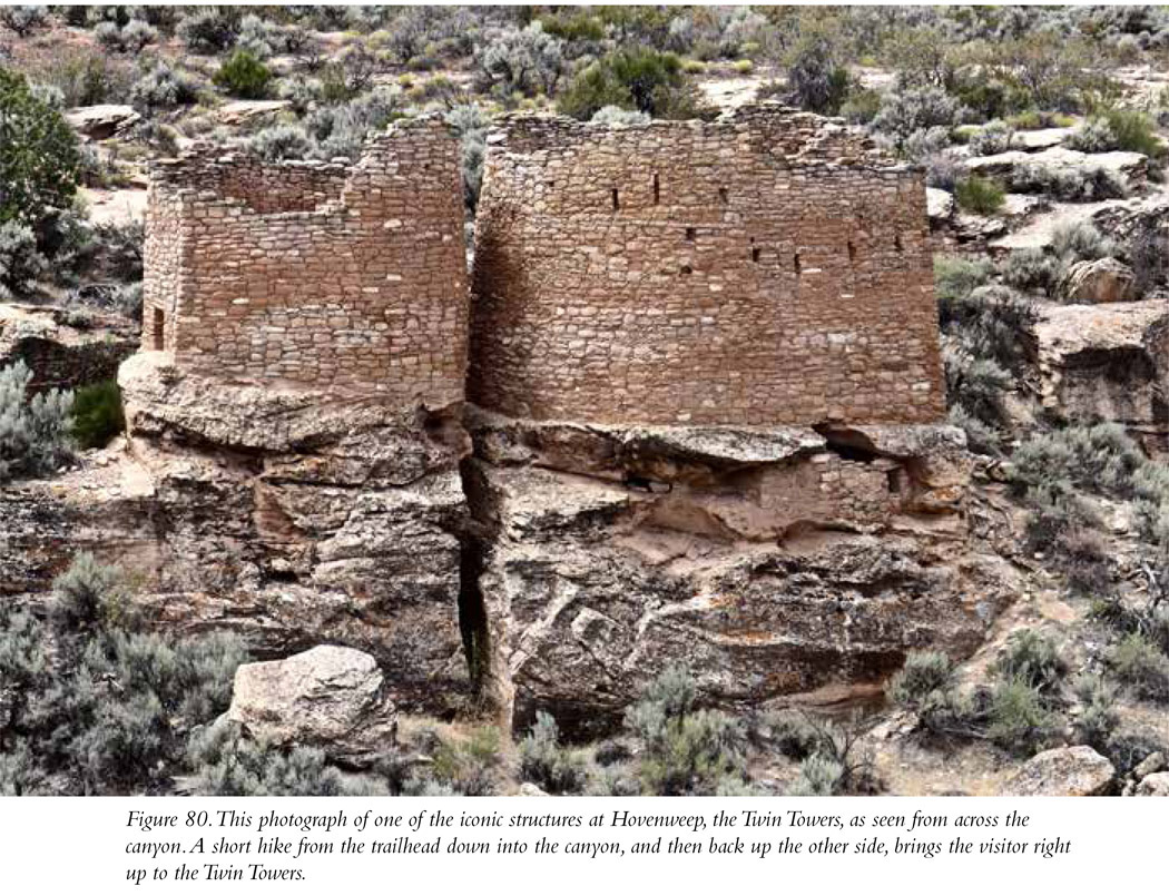
The Rim Trail takes you right up to the seven towers that dot the canyon’s rim. On the north side you’ll see in sequence as you hike to the west: (1) Stronghold House, (2) Unit Type House, (3) Tower Point (you’ll see this tower only if you take the Tower Loop Trail), and (4) Hovenweep Castle. After passing south around the western end of the canyon, you’ll turn back east and see (5) Hovenweep House, (6) Rim Rock House, and (7) Twin Towers (my favorite; Figure 80). You can also take the hike in the other direction, starting with Stronghold House and, instead of walking west along the rim, taking the trail down into the canyon and then up onto the south rim. Either way, along the trail you’ll also get great panoramic views of each of the seven rim towers from the opposite side of the canyon as well as Round Tower and the very well-preserved multistory Square Tower, located within the canyon itself. It’s all quite beautiful and unique in its concentration of towers. Incredible; that’s the best way to describe it.
Why Is Hovenweep Important?
Hovenweep is unique. You won’t see this remarkable concentration of towers anywhere else in North America. It’s not entirely clear why, between about AD 1230 and AD 1275, the ancient inhabitants constructed so many towers and fortresslike structures. All of them are “intervisible,” meaning you can see each structure from each other one along the rim of this canyon. Some of the towers (for example, Hovenweep Castle and Unit Type House) were inhabited and have windows whose positions appear to have been designed to align with the rising of the sun at the solstices and equinoxes. Tall towers would have provided a clear view of sunrise, so that might explain the architectural form. A calendar based on the sun that told farmers when to begin preparing the fields, when to plant, and when to harvest would have been a valuable tool for those living in an agriculturally challenging region like the Southwest.
Perhaps the towers were built as lookouts, defensive structures that provided residents a broad view of the surrounding territory and ample notice of the appearance of potentially dangerous strangers. Towers might also have functioned as communication beacons, with a warning flame set at their apexes when danger approached. We can continue to speculate, but for our purposes it’s enough to know that Hovenweep is an amazing place.
Site Type: Stone Tower
Wow Factor: **** The Hovenweep towers are very impressive.
Museum: ***
Ease of Road Access: *** There are some unpaved roads along the way, but they are well maintained. You won’t need a four-wheel-drive vehicle or one with particularly high ground clearance.
Ease of Hike: *** You’ll hike down into the canyon and back up to do the entire trail. It’s a very nice and pretty easy hike.
Natural Beauty of Surroundings: ****
Kid Friendly: ****
Food: Bring your own.
How to Get There: Hovenweep is located in southeastern Utah, hard fast against the border with Colorado. From US 191 in Utah, take UT 262 east. Where UT 262 cuts south (to the right), continue straight instead. Pass the Hatch Trading Post and take the road to the right, following the signs to Hovenweep.
From the Colorado side, from US 491 take the road labeled either CC or BB to CR 10. Take CR 10 west and follow the signs to the visitor center.
Hours of Operation: Open daily 8 a.m. to 6 p.m. April through September; 8 a.m. to 5 p.m. October through March
Cost: See website.
Best Season to Visit: Any time is good, but it can be pretty hot in summer.
Website: www.nps.gov/hove/index.htm
Designation: National Monument