Bighorn National Forest, Wyoming
Journal Entry
August 22, 2014
The weather was awful, and by that I mean perfect.
On the previous day we had driven from Billings, Montana, to the Little Bighorn Battlefield National Monument in Crow Agency to see the memorial to the US soldiers, Indian warriors, and, as it turns out, horses who died in battle on those two terrible days of June 25 and 26, 1876. It is an amazing and evocative memorial, and clearly deserves to be included in another book focused on the fifty historical sites every American should see. After spending a day at the memorial, we drove south to Sheridan, Wyoming, to spend the night. Next, on the morning of August 22, we drove west 70 miles into the Bighorn National Forest, climbing to an elevation of about 9,600 feet until we came to the well-marked turnoff for the Bighorn Medicine Wheel.
During the 90-minute drive, we repeatedly drove into and then back out of the clouds as the road ascended into the heart of the Bighorn Mountains. The mist-shrouded mountainscape was incredible, beautiful, and also eerie. When we finally arrived at the parking area for the Medicine Wheel Trail, it was apparent that the clouds were not going to dissipate, at least not in any significant way; but the mood created seemed completely appropriate. Walking uphill 1.5 miles in the cold and thick mist to the medicine wheel, we caught glimpses of the surrounding peaks blanketed in thick fog and cloud banks. All was not gloomy, however. Along the way we laughed at the fat, furry, and playful marmots, critters that look a bit like groundhogs, scurrying among the rocks. Their cuteness was trumped by that of the tiny, impossibly adorable pikas, which look sort of like a cross between a hamster and a rabbit, but lacking the big ears. (Legend has it that Pikachu in the Pokémon universe is modeled on these little and quite real critters.) The animals were very active because, though it was only late August, they were already collecting food for the coming winter snows.
I cannot adequately describe the feelings engendered as we walked at 9,600 feet amid the clouds, pelted by cold drizzle in August, and then finally encountered the amazing, ancient monument that has served as a pilgrimage destination for local Native Americans for hundreds of years. I have been to Stonehenge in bright sunshine, and I have been there on a cloudy, rainy day. I got better photos on the sunny day, for sure, but the hair on the back of my neck rose only on the gloomy day. I had a similar feeling when standing adjacent to the Bighorn Medicine Wheel as the pale mist slowly skittered among the stone cobbles that make up the monument, providing only brief glimpses of the form of the site. It just felt right, as though this was how it was meant to be seen.
What You Will See
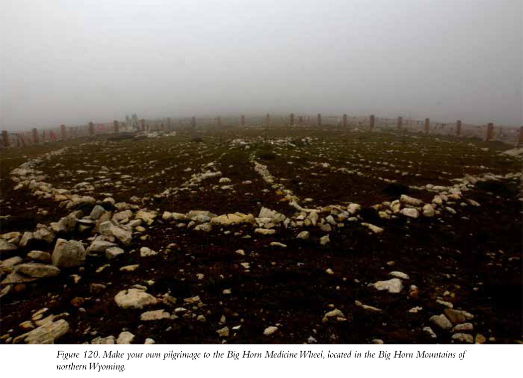
The Bighorn Medicine Wheel is the best preserved of a category of sites located throughout the northern plains of the United States and Canada. All together, there are about seventy existing medicine wheels, most of them in Alberta. The form of these sites is based on a common plan: stone cobbles laid out in a large circle on a flat surface, a separate pile of stones creating a hub in the center of the circle, and linear arrangements of stones radiating out from that central hub, extending out to the edge of the circle (Figure 120). These monuments are called “wheels” because they look like giant, recumbent, spoked wagon wheels.
The Bighorn Medicine Wheel likely was created between about 800 and 300 years ago and is still being used by Native Americans as a sacred pilgrimage destination. It is sprawling, with a diameter of about 75 feet. Along with its central cairn of stones, there are twenty-eight lines, or “spokes.” That number likely is significant, likely reflecting the number of days in a lunar cycle. Additionally, in the Bighorn example there are four more stone piles located along the outside of the stone circle. The place is quiet, the air is thin (at least to this sea-level dweller; the highest point in my state of Connecticut is barely 2,300 feet), and the landscape is rugged and magnificently alien. The surroundings, along with limited visibility in the mist, made it impossible not to contemplate the meaning of the place. It seems certain that it was intentionally placed in this landscape to elicit in those who visited it at as a sacred place many of the same feelings of awe and mystery engendered in the modern visitor.
The monument itself is surrounded by a fence consisting of thick wooden log posts and heavy rope. Many visitors, continuing what may be an ancient tradition, leave offerings tied to the rope. Part of the reason for the fence is to keep people from walking onto and possibly disturbing the monument. Because the wheel is large, a wide-angle lens is required to capture the entire monument in a single photo. GoPros have very wide-angle lenses and, mounted on a selfie-stick and then raised high above your head, are a terrific choice for photographing the medicine wheel.
Native Americans, following their historical traditions, are able to enter the monument for worship. When this takes place, non-Indian visitors are asked to respect those traditions and wait to take photographs until the ceremonies are complete. Imagine tourists entering into your place of worship and taking pictures of you during your ceremonies. That would be rude.
Why Is the Bighorn Medicine Wheel Important?
It is fascinating to consider that people all over the world, in their myriad, distinct, and unrelated cultures, incorporated circular features into their sacred architecture. There are literally hundreds of stone circles (consisting of upright stones) all over Europe, for example, dating back more than 4,000 years ago. Stonehenge, the best known, is in many ways unique, but it’s still fundamentally a circle of stones. It is reasonable to suggest that a circular structure built on a large scale may have been intended to represent a model of the horizon and, in turn, the world. At Stonehenge it seems pretty clear that stones were positioned to mark significant points on the horizon; for example, the place where the sun rises on the summer solstice. The spokes and cairns of the Bighorn Medicine Wheel might have served a similar purpose, marking key seasonal locations of the sun’s and the moon’s celestial voyages across the horizon.
For local Native Americans, the Medicine Wheel has long been a place where people go for vision quests—a sacred destination where, perhaps in isolation, a person contemplates the sacred, seeks out the divine, and reaches out to touch the face of his or her god. If you visit the Bighorn Medicine Wheel, at the very least you’ll gain a firsthand appreciation for such a quest. The raw beauty of the place, the overwhelming majesty of the landscape, and the remarkable stone monument situated in its midst; well, it all makes sense that this would be a place to go to contemplate your place in the universe.
Additional Note
Realistically, the site is accessible only in summer, and even then you need to check before attempting a visit. At an elevation close to 10,000 feet, weather can be pretty vicious. It snows a lot in the area, so much so that the access road, US 14 Alt., closes down completely for long stretches. We were there in August, and a ranger told us there was snow on the ground as late as June! Figure July and August are the best times to go, but always check whether the roads are passable before attempting to visit the medicine wheel.
Site Type: Geoglyph
Wow Factor **** The medicine wheel itself is remarkable, and it still being used by Native Americans. It is a living place, not an abandoned ruin.
Museum: None
Ease of Road Access: ****
Ease of Hike: ** The hike from the trailhead to the medicine wheel is 1.5 miles, pretty much uphill all the way. That can be a tough slog at 9,600 feet if you’re unaccustomed to that altitude. At least the 1.5-mile hike back to the parking lot is downhill.
Natural Beauty of Surroundings *****
Kid Friendly: **** Even if your kids aren’t that interested in the medicine wheel, the adorable marmots and the even more adorable pikas that frolic along the trail will get their attention.
Food: Bring your own.
How to Get There: From Lovell (heading east) or Sheridan (heading west), hop onto US 14 Alt. and continue until you reach the intersection with WY 12. The intersection is in about 67 miles on the north (right) side if you’re approaching from Sheridan and about 32 miles on the north (left) side if you’re approaching from Lovell. There’s a sign at the intersection directing you to the medicine wheel. Turn onto WY 12; it will take you directly to the parking lot, about 3 miles after you make the turn, where you will find a little ranger station and toilets. There should be a ranger on site to answer any questions you might have about the place.
Hours of Operation: When the site is accessible (see the “Additional Note” for this entry), it is open dawn to dusk.
Cost: Free
Best Season to Visit: Basically, August
Website: http://solar-center.stanford.edu/AO/bighorn.html
Designation: National Forest