
The trails at Historic Blakeley State Park lead you to some of the best-preserved breastworks and redoubts in the region.
9 Historic Blakeley State Park
Historic Blakeley State Park looks like a postcard of the archetypal South: long, flowing Spanish moss hanging from the trees, shady walkways along the riverbank, and let us not forget Civil War history. While General Lee was surrendering to Grant in Virginia, the last major battle of the war was being waged here. Today the park is a Civil War National Historic Site and a great hike along the banks of the second-largest river delta in the country.
Start: Parking lot along Mobile Bay
Distance: 4.1-mile multiloop
Hiking time: About 2.5 hours
Difficulty: Moderate due to length, easy if you break the hike down into one of the shorter sections
Trail surface: Dirt path, gravel road, boardwalk
Best seasons: Sept–May
Other trail users: Cyclists, motorists (on road sections), equestrians
Canine compatibility: Leashed dogs permitted
Land status: Historic state park
Nearest town: Spanish Fort
Fees and permits: Day-use fee (under 6 free)
Schedule: Year-round, 9 a.m.–dusk (gate often opens at 8 a.m.)
Maps: USGS Bridgehead, AL; DeLorme: Atlas & Gazetteer, page 62 C5; brochure with map available at office
Trail contact: Historic Blakeley State Park, 34745 AL 225, Spanish Fort, AL 36527; (251) 626-0798; www.blakeleypark.com
Finding the trailhead: From the intersection of US 98 and AL 225 in Spanish Fort, take AL 225 north 5 miles. The park entrance is on your left. Once you pay the attendant, travel 2 miles, continuing straight on Old Blakeley Road to its end at the boat ramp. This is the trailhead for the hike. GPS: N30 44.851' / W87 55.400'
The Hike
The Paleo Indians were the first to live in the area now occupied by Historic Blakeley State Park some 4,000 years ago. The land changed hands numerous times over the years and would fall under the rule of several countries during its history, including Spain in the late 1500s and France in the early 1700s, followed by Britain, and then the United States in 1813. Soon after becoming a US territory, Josiah Blakeley stepped into the picture and bought this land and established the town of Blakeley.
The town, long since vanished, was chartered in 1814 and became a bustling port city that rose to rival neighboring Mobile. By 1828 a series of yellow fever epidemics, coupled with the greed of land speculators, forced the city of 4,000 into a spiral of decay, and by the mid-1800s it was abandoned. Today all that remains of the old port town are the 400-year-old live oaks that once lined the city streets and a recently unearthed foundation—the original brick and wood base of the town’s courthouse.
The town’s greatest claim to fame came on April 8, 1865. It was on that date that 55,000 Union and Confederate soldiers converged in the fields surrounding the old town. The Union army intended to seize Fort Blakeley and then attack and capture the city of Mobile from its eastern shore.
The fighting was fierce—216 killed, 955 wounded, and 3,054 captured (3,050 of them Confederates). It was a decisive Union victory, but what made the battle significant had little to do with the casualties. On the second day of this two-day campaign, Confederate general Robert E. Lee surrendered to Union general Ulysses S. Grant at Appomattox Courthouse in central Virginia, thus making the battle at Blakeley the last major battle of the Civil War.
More than a hundred years later, in 1974, the Alabama Historic Commission placed the site on the National Register of Historic Places and the effort to preserve the battle site began. Trails were built, breastworks were located, and in 1993 Congress designated the site a Class A Civil War Site. Three years later it was added to the National Civil War Trail list. Be sure to pick up a brochure at the entrance gate that describes the battle through numbered signs along the trail.
Within Historic Blakeley State Park’s 3,800 acres are a total of 15 miles of nature and historic trails. The trails cross one another so that you can form shorter or longer loops to suit your schedule or what you want to see.
The trails at Historic Blakeley State Park lead you to some of the best-preserved breastworks and redoubts in the region.
Since we last visited Blakeley, there has been a new addition: the original brick and wood foundation of the town’s courthouse. It’s an impressive structure to view, and you will pass it along this hike.
Not only is Blakeley steeped with history, but it is filled with natural beauty as well. This hike will take you past the Wehle Nature Center, which is used for conferences and special presentations (visit the park’s website for schedules). There is also a display behind the building of some of the wildlife that calls the Mobile-Tensaw River Delta home.
The trail will also take you down a boardwalk along the banks of the second-largest river delta in the country and one of the largest intact wetland systems left in America, with over 300,000 acres of swampland, river bottom, and marshes. The delta plays host to 300 species of birds, 70 percent of all of Alabama’s reptiles, and 40 different species of mammals. It is one of the largest drainage basins in the world, with runoffs from four states feeding into it and into the Gulf of Mexico. Blakeley is at the very southern end of the delta but has exceptional views of some marshland and views across the river of the city of Mobile.
The hike begins at the park’s boat ramp at the very end of the main road into the park. There is room for about fifteen cars here and a nice portable toilet. Your trip begins along the Jaque Pate Nature Trail. Along this section you will be walking through some bottomland. Many of the trees in this area have signs indicating what you will see. Some species include live oak, saw palmetto, and yellow poplar.
The Cockleshell Mound Trail then takes you past the Wehle Nature Center and a dirt road that takes you to the battlefield where some of the best-preserved breastworks and redoubts from the Civil War can be seen. You will also head over to the Union side to see the “Zig Zag,” an approach trench that took the Union soldiers right up to the Confederates doorstep at the redoubts.
The path returns the way you came, taking a turn on the nature trail farther down Old Blakeley Road to the site of the old courthouse, the Mary G. Grice Pavilion, and then the walk along Mobile Bay on the boardwalk.
Options: There are several intersections along the way, so you can make the hike as long or as short as you like. The hike described here can easily be divided into three separate routes. The first is the loop from the trailhead to the courthouse foundation, then back to the trailhead on the boardwalk along the delta. The second would be a nature loop from the trailhead to the Wehle Nature Center and back. Finally, you can do a simple battlefield walk from the Wehle Nature Center and loop around the battlefield for a 2-mile hike.
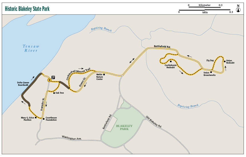
Miles and Directions
|
0.0 |
Start at the parking lot along Mobile Bay. In a few yards turn left onto the Jaque Pate Nature Trail, a narrow dirt and sand path through thick forest. Many tree species are identified with signage. The trail is not blazed but easy enough to follow. In 100 feet come to the Cockleshell Mound Trail boardwalk and walk across to the other side of a wetland. |
|
0.2 |
On the other side, make a left turn to the north onto an unnamed trail. In 20 feet cross another boardwalk. As of this writing, the boardwalk was in disrepair with loose boards and tipped to an angle; be cautious crossing. |
|
0.3 |
Climb down a steep set of stairs. The treads are far apart, so be very careful climbing down. Many people walk next to the stairs, which is causing an erosion issue. |
|
0.4 |
Come to the intersection with Green Street Extension, a wide dirt and gravel road. Turn left (east) onto the road. From here on to the battlefield, the trail is open with little shade. |
|
0.5 |
Pass the Wehle Nature Center. |
|
0.6 |
Green Street Extension dead-ends at Battlefield Road. Turn left (north) onto the road and head to the battlefield. |
|
0.8 |
Cross Baptizing Branch, with a wetland on the right. |
|
1.0 |
Pass Marker #3. Turn right (south) on a dirt road and head to the redoubt. |
|
1.1 |
Arrive at Redoubt #2. Walk around on the right side. |
|
1.3 |
Pass Marker #16. Turn right (southeast) and head across the grassy battlefield. In less than 0.1 mile, arrive at another dirt road. Turn right (south) onto the dirt road. |
|
1.4 |
Pass Marker #15. In a few yards pass a dirt road on the right and Marker #5, then in a few feet Marker #6. Union trenches can be seen along this stretch. |
|
1.5 |
Arrive back at Battlefield Road at Marker #14 and turn right (east) onto it. |
|
1.6 |
Pass Marker #7 on the left (this will be the return route for the loop end of this section). Continue straight (east) on the dirt road and in a few feet pass Marker #9. One hundred feet later, cross the Union breastworks. |
|
1.7 |
Arrive at the Union redoubt. Walk to the far end and turn left (west). Follow the clear-cut in the thick grass to the left (southwest), following the “Zig Zag” on the left. |
|
1.9 |
Come to Marker #8. Turn right and head back to the main park road. In 200 feet return to Battlefield Road. Turn right (west) onto the road and head back to Green Street Extension at mile 0.4. |
|
2.5 |
Turn right onto Green Street Extension and head back the way you came. |
|
3.2 |
At the intersection with the Cockleshell Mound Trail, continue straight on Green Street Extension until you come to a cul-de-sac in the dirt road. A sign with a blue arrow about 10 feet off the ground is hung on a tree indicating the route to take. Follow the arrow onto a sandy footpath to the right (southwest). Once again the trail travels through a thick forest with a good canopy. |
|
3.4 |
Return to the Cockleshell Mound Boardwalk and cross it to the northwest. In less than 0.1 mile, come to the end of the boardwalk at the Jaque Pate Nature Trail. A sign here reads “Parking Area 0.1 Mile” (arrow pointing to right) / “Trail Fork 0.2 Mile” (arrow pointing to left). If you take the right turn to the north, you will return to the parking lot. Instead, turn left (south) onto the nature trail. The vegetation is very thick here. |
|
3.6 |
Come to a Y at a large live oak tree (the tree is indicated by an informational sign). Take right fork (west) onto a short spur trail. In less than 0.1 mile, you will be back at Old Blakeley Road. If you want to return to your vehicle, turn right (north); otherwise, turn left onto the road and head south. |
|
3.7 |
Pass the foundation of the old courthouse. Turn left (west) here, cross the road through a wood fence, and head toward the Mary G. Grice Pavilion. In a few yards arrive at the pavilion. There are picnic tables and grills here. Behind and to the right of the pavilion is a sign describing big-leaf magnolia trees and a large cement barbecue grill. The Nature Trail begins here, with descriptive signs for Florida anise, live oak, saw palmetto, yellow poplar, American beech, and pignut hickory. In less than 0.1 mile, arrive at the delta boardwalk. Follow it to the north. |
|
4.0 |
Come to the end of the boardwalk (the Delta Queen tour boat is docked here). Turn right onto the dirt road. |
|
4.1 |
Arrive back at the trailhead. |
Hiking Information
Local Information
Eastern Shore Chamber of Commerce, 29750 Larry Cawyer Dr., Daphne, AL 36526; (251) 621-8222; www.eschamber.com
Local Events/Attractions
Annual Battle of Blakeley Reenactment, 34745 AL 225, Spanish Fort; (251) 626-6798; www.blakeleypark.com. The event occurs around the weekend of the actual battle date of April 9.
Blakeley Bluegrass Festival, 34745 AL 225, Spanish Fort; (251) 626-6798; www.blakeleypark.com. Held annually in mid-October.
Lodging
Blakeley Historic State Park Campgrounds, 34745 AL 225, Spanish Fort, AL 36527; (251) 626-0798; www.blakeleypark.com. Two separate campgrounds, one for RV use the other for tent and pop-ups only.
Restaurants
Blue Gill, 3775 Battleship Pkwy., Spanish Fort; (251) 625-1998; www.bluegillrestaurant.com
Original Oyster House, 3733A Battleship Pkwy., Spanish Fort; (251) 626-2188; www.theoysterhouse.com