
Much of the Muddy Creek Interpretive Trail is over long boardwalks through wetlands.
10 Muddy Creek Interpretive Trail
A beautiful family-friendly hike featuring many boardwalks that lead you through and educate you about the amazing wetlands and longleaf pine ecosystems found on Alabama’s Gulf Coast and how industry can take a lead in preserving the environment.
Start: Parking lot on Industrial Road
Distance: 2.2-mile lollipop
Hiking time: About 1.5 hours
Difficulty: Easy over flat, level ground
Trail surface: Dirt and clay footpaths, boardwalk
Best seasons: Late Feb–mid-May
Other trail users: None
Canine compatibility: Leashed dogs permitted
Land status: State wetland preserve
Nearest town: Theodore
Fees and permits: None
Schedule: Year-round, dawn to dusk
Maps: USGS Theodore, AL; DeLorme: Alabama Atlas & Gazetteer, page 62 F3
Trail contact: Alabama State Port Authority, 250 N. Water St., Mobile, AL 36602; (251) 441-7001; www.asdd.com
Finding the trailhead: From the intersection of US 90 and Bellingrath Gardens Road in Theodore, take Bellingrath Gardens Road south 2.2 miles. Turn left onto Industrial Road and travel 1 mile. The paved parking lot is on the left. GPS: N30 31.029' / W88 09.158'
The Hike
So, I live on Alabama’s Gulf Coast and thought I had hiked all there is to hike down here. Then I saw online a posting for someone leading a hike on the Muddy Creek Interpretive Trail in the town of Theodore. Curious, I shot them an e-mail and asked where Muddy Creek was and what it was like. They replied that they didn’t know. They had only heard a vague mention of it themselves from a friend and thought they would check it out. And so did I.
You wouldn’t think that there would be much to the hike when you consider the trail’s location. You are in the bustling town of Theodore on the west side of one of the state’s biggest counties, Mobile, heading to the trailhead down a road called Industrial Road through an area known for its chemical plants. But there it was, and what a great little hike.
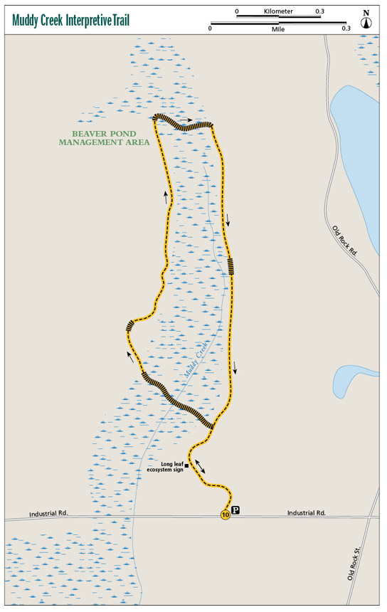
The Muddy Creek Interpretive Trail is a 2.2-mile lollipop loop through wetland areas on the western bank of Mobile Bay. The property itself is owned by the Alabama State Port Authority, the folks who handle shipping in and out of the bay. The trail project began in 1998, when it was decided that the best use of the property was to preserve and enhance the wetland as part of a wetland mitigation measure. Five long, hard years later, the trail was completed.
Some of the goals of the Muddy Creek project included the removal and control of invasive exotic plant species, restoration of native wetland and upland plant ecosystems, installation of nesting boxes, replanting of 66 acres of upland agricultural fields with native longleaf pines, and the development of an interpretive trail and boardwalk system. The first goal, the removal of invasive plants, proved challenging. The process was all done by hand—everything from pulling bushes to hand-cutting trees to treating stumps with herbicide then replanting native species. By the time the project was completed, it had become the largest invasive plant removal ever in the state.
Much of the Muddy Creek Interpretive Trail is over long boardwalks through wetlands.
The resulting interpretive trail is a fascinating educational experience and nice walk in the woods, one that is suitable for families with children of all ages, over wide, packed dirt paths and long boardwalks. If you have younger children, you may want to cut the trip short due to the length.
The path is well marked with metal directional signs, and at key turns in the trail, a large map of the route shows you where you are. Throughout the trek there are informational signs that identify the many species of native trees you will pass, such as tupelo gum, sweet bay, red maple, wax myrtle, and bald cypress. Signs also describe the wetland ecosystem and the Muddy Creek project itself.
The hike begins along a 0.2-mile paved section of trail, but after that it is a wide, hard-packed dirt and clay path. Several long boardwalks are encountered on the trip over beautiful wetlands and streams, including the trail’s namesake. Remember, water in streams and wetlands can be seasonal in Alabama. The best time to visit is late February to mid-May, when the spring rains are plentiful along the Gulf and the creek is wide and flowing, and the wildflowers and trees are blooming. The boardwalks are wide, with tall handrails and an occasional viewing platform or bench.
One of the more interesting boardwalks at the northern end of the loop takes you through a beaver pond management area. As the sign will tell you, beavers were once considered nuisances but it was found that the careful management of beaver ponds results in a healthier wetland system.
As you head back, you will be treated to a few sections of trail where the footing is thick green moss. The cushion of the moss is quite the transition from the hard-packed dirt, and on sunny days the moss has a beautiful green glow to it.
Miles and Directions
|
0.0 |
Start at the parking lot trailhead on Industrial Road. A Muddy Creek Interpretive Trail sign is here that shows the route of the trail. Head north on a paved path a few yards and come to a Y. The right fork is a dirt road. Turn left (west) and continue following the paved path. You will soon see the first of many signs describing the habitat you will be walking through. |
|
0.2 |
The paved path comes to a T intersection with another paved road. Cross the road to the north and enter the woods on a narrow footpath. Through this section you will be surrounded by longleaf pines. |
|
0.3 |
Come to a Y in the trail. A map here shows you where you are. The right fork is the route you will be returning on. Take the left fork (northwest). A long boardwalk begins in about 30 feet. The boardwalks are very nice, with high railings. Through here you’ll see tupelo gum, sweet bay, elderberry, red maple, and bald cypress trees. |
|
0.4 |
The boardwalk crosses Muddy Creek. (FYI: The streams and wetlands are seasonal and may be dry at certain times of the year.) |
|
0.5 |
The boardwalk ends at another trail map sign and turns to the right (north). |
|
0.6 |
Cross a short, 30-foot boardwalk. |
|
0.7 |
The trail gets very dense with longleaf pines and wax myrtles. |
|
1.1 |
Pass another trail map sign and in a few yards cross another boardwalk. This is the north end of the loop. |
|
1.2 |
Pass a series of signs with information on beavers and their importance to the wetland. |
|
1.3 |
The boardwalk ends at another trail map sign and the trail turns to the right (south). |
|
1.6 |
Pass another trail map sign and cross another short boardwalk. |
|
1.7 |
For a few hundred feet the trail bed is soft, green moss. Along this section you’ll see a steel cable with yellow metal posts through the trees to your left (east). This is a barrier for a dirt road that parallels the trail. |
|
1.9 |
Return to the Y at the southern end of the loop. Take the left fork to the south and retrace your steps to the trailhead. |
|
2.2 |
Arrive back at the trailhead. |
Hiking Information
Local Information
Mobile Bay Visitors and Convention Bureau, PO Box 204, Mobile, AL 36601; (800) 566-2453; www.mobile.org
Local Events/Attractions
Bellingrath Gardens and Homes, 12401 Bellingrath Gardens Rd., Theodore; (800) 247-8420; www.bellingrath.org. An array of color, fragrances, and scenic views are in store for you year-round at this world-renowned garden. Don’t miss the Magic Christmas in Lights display from Thanksgiving to New Year’s Day.
Restaurants
Time to Eat, 7351 Theodore Dawes Rd., Theodore; (251) 654-0228; www.timetoeatmobile.com. Offers mountains of some of the best Southern down-home cooking for dine in or take out.