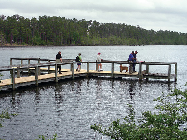
Hikers take a look at the lake at Little River State Forest on a T fishing pier.
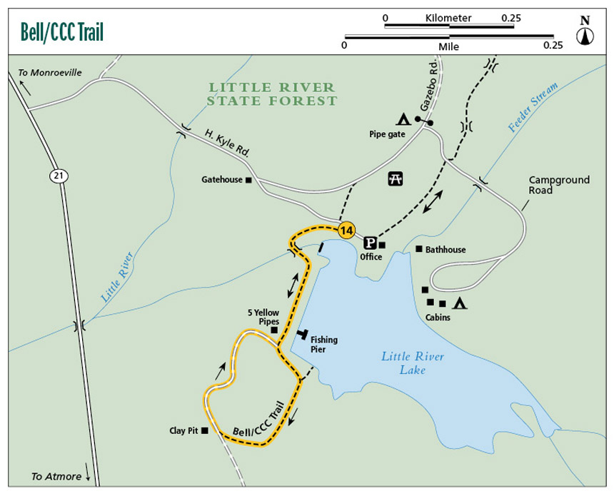
14 Bell/CCC Trail
A wake-up call for those who have hiked the flatter trails of the Gulf Coast region, the Bell/CCC Trail leaves the sea-level hiking behind and starts to take on some hills. Granted, these are not massive mountains, but some of the inclines can get you breathing hard if you’re not in reasonably good shape. The trail crosses the beautiful spillway that flows from the dam that forms Little River Lake, then rounds the lake before ducking into a thick forest where some nice views of the surrounding hills will be had at the top of the ridge.
Start: At the park office and bathhouse
Distance: 2.0-mile lollipop
Hiking time: About 1.5 hours
Difficulty: Easy to moderate due to hill climb
Trail surface: Dirt footpath, dirt road
Best seasons: Year-round
Other trail users: None
Canine compatibility: Dogs permitted but must be on leash in recreation area
Land status: Alabama state forest
Nearest town: Atmore
Fees and permits: Day-use fee; paddleboat rental and lake zip line fees
Schedule: Year-round, 9 a.m.–5 p.m.; zip line open weekends Memorial Day–Labor Day
Maps: USGS Uriah East, Uriah West, Huxford, and McCullough, AL; DeLorme: Alabama Atlas & Gazetteer, page 57 D6
Trail contact: Little River State Forest, 580 H. Kyle Rd., Atmore, AL 36502; (251) 862-2511; www.forestry.state.al.us/little_river_state_forest.aspx?bv=6&s=2
Finding the trailhead: From I-65 exit 57, take US 21 north 11 miles. Turn right onto H. Kyle Road and travel 0.4 mile to the pay station. The park office and the start of the trail are straight ahead in another 0.2 mile. GPS: N31 15.436' / W87 29.129'
The Hike
The folks who drive past Little River State Forest (formerly Claude D. Kelley State Park) and never stop to visit don’t know what they’re missing. The forest, hidden in the woods about 11 miles north of Atmore, features nearly 2,000 forested acres and the 25-acre Little River Lake. This man-made lake provides swimming and fishing year-round. The Bell/CCC Trail affords wonderful views of the lake, plus a bit more of a hiking challenge than many other south Alabama hikes.
The Civilian Conservation Corps (CCC) built the park in 1935 (you can view an actual film of the construction of the park online at www.youtube.com/watch?v=N23Vpy6VTmw). This trail utilizes an old dirt road that was once used by CCC workers and a newer trail built by former Alabama forestry ranger Paul Bell, hence the name Bell Trail. The combination of the two trails gives you a nice walk in the woods with exceptional views of the lake and of the surrounding hills at the intersection of the two.
The park is located in Monroe County, which was immortalized in Harper Lee’s To Kill a Mockingbird, the best-selling novel about racial tensions in a small Southern town. The story was set in Maycomb, a fictional alias for the nearby town of Monroeville.
This region is home to the Poarch band of Creek Indians. Following the 1814 Battle of Horseshoe Bend, which pitted the Creek’s Red Stick band against US soldiers and the Lower Creek tribe, the federal government relocated most of the local tribes to Oklahoma. In appreciation for fighting alongside General Andrew Jackson’s troops, the Poarch Creeks were allowed to establish a reservation here. Each Thanksgiving the tribe invites the public to its annual Thanksgiving Pow Wow that features native foods, rituals, costumes, and dances. The pow wow is held on the Poarch Creek Reservation on Jack Springs Road in Atmore (see “Local Events” below).
Hikers take a look at the lake at Little River State Forest on a T fishing pier.
The Bell/CCC Trail begins by tracing the banks of Little River Lake. Early on, you cross the lake’s overflow stream. The crossing makes for a scenic spot to sit and just watch the rushing waters.
After following the banks of the lake over a man-made earthen dam, the trail turns and heads southeast into the woods, where it follows a nice, narrow 3- to 4-foot-wide dirt bed. Here loblolly and longleaf pine, sweet gum, and hickory fill the forest. In the fall live oaks provide a sparkling display of color that reflects from the surface of the lake. In early spring the dogwood blooms are particularly beautiful. While hiking, be sure to watch for the many varieties of woodpeckers that live here, including downy, hairy, red-headed, and pileated.
Eventually the trail moves away from the lake and begins to head up the side of a ridge that has a grade that is much steeper than most other south Alabama hikes covered in this guidebook, but the average hiker shouldn’t find it too difficult. As the trail nears the top of the ridge, it becomes an old dirt road. For the most part it is maintained, but sometimes after heavy rains you may find a few washouts, though nothing insurmountable.
At the top of a ridge, the trail comes to the very edge of the soft clay banks of a large pit. Be careful here: There’s a drop-off of 50 to 75 feet. Turn around and you will have a nice view of the rolling hills surrounding the forest, something you don’t normally see this far south. From the dirt pit you will turn to the right (northwest) and follow the old CCC Road downhill to complete the loop. This is a dirt road and a really nice walk in the woods. Be sure to keep your eyes peeled for the stone craftsmanship of the CCC. Along the sides of the road they constructed, by hand, stone culverts to keep water from washing the road away.
Miles and Directions
|
0.0 |
Start at the park office and bathhouse. The trail is blazed with the yellow markings of the Alabama Trail. Head southwest along the banks of the lake toward the park’s pay station and entrance. |
|
0.1 |
The trail comes to a 50-foot-long footbridge that spans the lake’s spillway. Cross the bridge heading to the south; once across, turn to the east and head back toward the lake. At the lake, turn right and follow the dirt road atop the earthen dam. |
|
0.3 |
Pass a T fishing pier that extends out into the lake on the left (east). |
|
0.4 |
Come to a T intersection. To the right you will see a dirt road. This is the CCC Trail and will be where you will return. Turn left (southeast) into the woods. The trail is now a dirt footpath. |
|
0.5 |
Cross a short, 20-foot metal grate bridge over a small stream. |
|
0.6 |
Come to a Y. Take the right fork to the southwest. (FYI: The left fork is a side trail that takes you to a nice walk along the banks of the lake. It will eventually meet back up with the main trail at mile 0.7.) |
|
0.7 |
The side trail to the lake rejoins the main trail from the northeast. Continue about another 20 feet and come to a Y. Take the right fork to the southeast. (FYI: The left fork is the forest’s property line and is marked with yellow-and-white rings around the trees and has a grass-covered service road along the perimeter.) Soon the trail begins a pretty decent climb up the hill until the intersection with the CCC Trail. |
|
1.0 |
Come to a Y. Take the right fork up the hill to the southwest. The trail is now a dirt road that is usually well maintained but can sometimes have deep ruts after heavy rain. |
|
1.1 |
Come to a T intersection. Straight ahead is a clay pit. (FYI. Be sure to turn around and catch the views of the surrounding hills to the southeast.) Turn right (northwest) at the pit onto the dirt CCC Road. This is the un-blazed CCC Trail. |
|
1.7 |
The trail comes to the end of the loop that you first started at mile 0.4. Turn left (northeast) and retrace your steps over the earthen dam and spillway back to the trailhead. |
|
2.0 |
Arrive back at the trailhead. |
Hiking Information
Local Information
Atmore Chamber of Commerce, 501 S. Pensacola Ave., Atmore, AL 36502; (251) 368-3305; www.atmorechamber.com
Local Events/Attractions
Annual Poarch Creek Indian Thanksgiving Pow Wow, 5811 Jack Springs Road, Atmore, AL 36502; (251) 368-9136; www.poarchcreekindians.org/westminster/pow_wow.html. Each year the public is invited to celebrate Thanksgiving with the Poarch Creek Indians. The event brings tribal members together and features brilliant displays of authentic dress and exhibition dancing by a variety of tribes. In addition, there are arts and crafts, barbecue, fried chicken, and more.
Lodging
Little River State Forest Campground, 580 H. Kyle Rd., Atmore; (251) 862-2511; www.forestry.state.al.us/little_river_state_forest.aspx?bv=6&s=2. Primitive camping and improved sites (water and power).
Restaurants
Creek Family Restaurant, 6141 AL 21, Atmore; (251) 368-4422
Organizations
Alabama Hiking Trail Society, PO Box 231164, Montgomery, AL 36123; www.hikealabama.org

The beautiful spillway at Little River State Forest looks almost exactly as it did some eighty years ago.