
The limestone walls of the quarry can be seen as you hike along the trail at Old St. Stephens Historical Park.
15 Old St. Stephens Historical Park
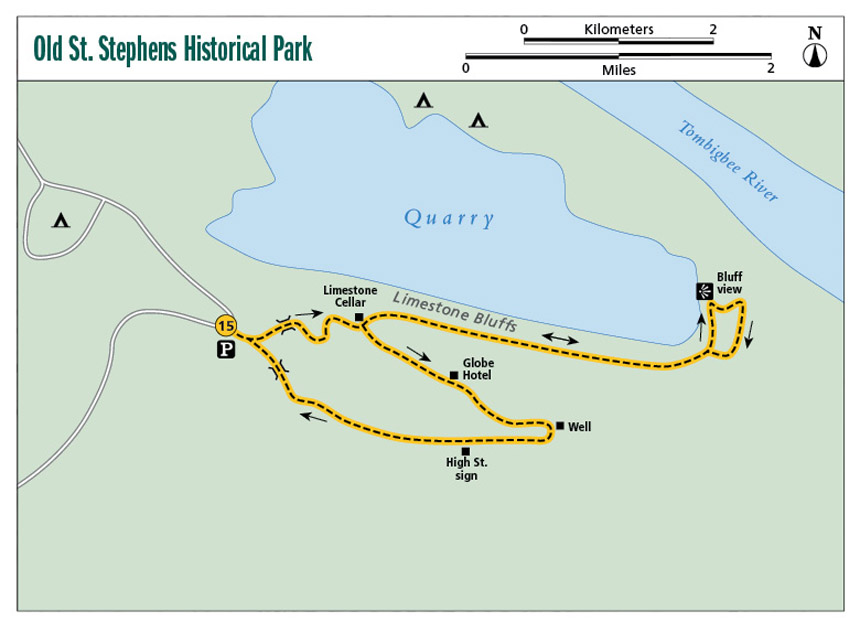
A little bit nature and a whole lot of history along the Old St. Stephens Historical Park Trail. This loop trail takes you along the banks of a quarry with water reflecting deep blue skies and white limestone bluffs, plus the history of the first capital of Alabama at a live archeological site.
Start: Trailhead adjacent to parking lot
Distance: 1.9-mile multiloop
Hiking time: About 2 hours
Difficulty: Easy to moderate due to some hills
Trail surface: Dirt
Best seasons: Late Feb–May, Sept–Nov
Other trail users: Equestrians
Canine compatibility: Leashed dogs permitted
Land status: City historic park
Nearest town: St. Stephens
Fees and permits: Day-use fee
Schedule: Year-round, 7 a.m.–3 p.m.
Maps: USGS Saint Stephens, AL; DeLorme: Alabama Atlas & Gazetteer, page 48 H5
Trail contact: Old St. Stephens Historical Commission, PO Box 78, St. Stephens, AL 36569; (251) 246-6790
Finding the trailhead: From Jackson and the intersection of AL 69 and US 43, take US 43 south 8.4 miles. Turn right onto Mobile Cutoff Road and travel 1.9 miles. Turn right onto Gib Bailey Road / Cement Plant Road. Travel 0.8 mile and come to a fork in the road. Take the right fork onto an unnamed street (Cement Plant Road continues on the left fork). The park entrance gate is ahead on the right in 0.2 mile. After paying the attendant, continue another 1 mile to the parking lot and trailhead. The trail begins at the information shelter that has details about the park and its history. GPS: N31 33.315' / W88 02.220'
The Hike
The Old St. Stephens Historical Park Trail is unique. Not only does it take you through some beautiful scenery, including great views of limestone bluffs (more on that in a moment), but it is also an active archeological site. Volunteers from around the country come to the park each year to help uncover a piece of the state’s history, the site of the first territorial capital of Alabama. As with many historic sites, Old St. Stephens is facing a financial crisis and is seeing its budget cut drastically, but dedicated volunteers do a remarkable job at keeping the gates open.
The trail that meanders through the site gives you a unique perspective of this 220-plus-year-old city. The town of Old St. Stephens has an eclectic history, beginning as the site of a fort in 1789 that was built by the Spanish governor of Mobile, Juan Vincente Folk. The location was perfect for the economy of the area. Built on a sharp bend in the Tombigbee River and high atop a limestone bluff, ships would have to dock here because after the bend the river shallows.
The fort was eventually turned over to the United States, and in 1799 the town began growing exponentially. At the height of its success, Old St. Stephens sported high-class boardinghouses, hotels, theaters, and the state’s first chartered school, Washington Academy.
The Alabama Territory was formed in 1817, and Old St. Stephens became the state’s first capital, thus giving the park its motto, “Where Alabama began.” But success was short-lived. In one year the capital was moved to Cahawba, and as it moved, so did the population, which relocated a few miles away to New St. Stephens.
The limestone walls of the quarry can be seen as you hike along the trail at Old St. Stephens Historical Park.
The town fell into ruin and was reclaimed by nature until, through the efforts of the University of South Alabama Archeological Department, it was rediscovered, and now you can walk the streets of the long-forgotten town on this trail.
The trail begins by weaving its way through dogwood and redbud trees along the ancient streets. Signs along the route tell the story of life in the town at its zenith, when it boasted a population of over 7,000 people. The old streets are marked with signs such as “High Street,” and individual properties where houses once stood are identified by signs bearing their street address. One of the historical highlights of the hike is the site where archeologists are unearthing the grand Globe Hotel, once the main stopping point for travelers and businessmen in the region.
The trail deviates a bit from the archeological site as it treks along the banks of a large, deep quarry. The quarry is now full of water and makes an impressive picture when it reflects a deep blue sky. As you hike along the eastern bank of the quarry, be sure to turn around for a good view of the limestone bluffs that line the banks.
The trail is not blazed and can become a bit confusing to follow. There are several dirt service roads that run through the tract that can get you turned around. Also, be aware that equestrians use the trail, too. Keep eyes peeled for them as they round the bends.
If you’d like to do a little car camping while here, the park has two nice campgrounds. Lakeview is situated atop a limestone bluff high above the lake, with a wonderful view of the quarry. The second campground is a primitive area called Cedar Ridge, with easy access to the quarry for swimming. Keep in mind that this is a deep lake and there are no lifeguards on duty, so be safe.
Miles and Directions
|
0.0 |
Start at the trailhead a few yards to the southeast of the parking lot. A small building housing informative panels describing the town’s history and the site’s archaeology is there. The trail begins to the right of the building. In a few short yards, come to a Y. The right fork is the return route; take the left fork (east) and a few yards later cross a short bridge over a creek. Another short walk takes you to a sign that reads “You are now crossing Chambers Street” and describes where you are, but the rest of the sign is hard to read. Follow the path up the hill to a dirt road and turn to the right (east) onto the road. To the left you will see the archeological building. |
|
0.2 |
Pass the remnants of a limestone cellar labeled 142 High Street and a marble marker. Just past this the trail comes to a Y (a sign reading “High Street” is in the center of the Y). Take the left fork (northeast). Along this wide dirt road section, you will be walking atop the limestone bluffs of a quarry with beautiful blue water. (FYI: You can walk out to the bluff’s edge on several short side trails, but be warned, they are high and dangerous!) |
|
0.6 |
Come to a Y. Take the left fork (north). The trail narrows and has a nice enclosed feel. |
|
0.7 |
Just after passing a wide path to the right, continue straight (north) a few yards to get a look at the beautiful limestone bluffs behind you. Turn around and head back to the wide path you just passed. Turn left (east) and follow the dirt road. In less than 0.1 mile, the trail comes to a Y. Take the left fork down into a gully and back up the other side to the dirt road at the top of the hill. Turn right (south) onto the dirt road. |
|
0.8 |
Return to the Y from mile 0.2 (the High Street Y). Take the left fork and head west on the wide dirt road. To your right along this section, 4-by-4 white posts mark the property lines of houses that once stood here; some have signs marking the address. There are also signs with articles from newspapers of the day (late 1800s). |
|
1.3 |
Come to the archeological dig of the Globe Hotel. |
|
1.4 |
Pass a well house on the right. Circle around the well to the south and pick up the dirt road on the other side. Turn right here onto the dirt road to the southeast. |
|
1.6 |
Come to a sign that reads “132 High Street” and a narrow, 2- to 3-foot-wide dirt footpath coming in from the left. Turn left (west) onto the footpath. |
|
1.7 |
A trail comes in from the left. Keep heading straight (west). |
|
1.8 |
Come to a creek crossing. There are two bridges here; use the smaller one on the left. |
|
1.9 |
Arrive back at the trailhead. |
Hiking Information
Local Information
Washington County Economic Development, PO Box 854, Chatom, AL 36518; (251) 847-2810; www.washingtoncountyal.com
Accommodations
Old St. Stephens Historical Park Campground, Cement Plant Road, St. Stephens, AL 36569; (251) 246-6790. RV, primitive, and improved tent camping is available.