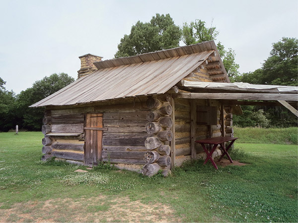
A single log cabin is all that remains of the original Fort Toulouse from the mid-1700s.
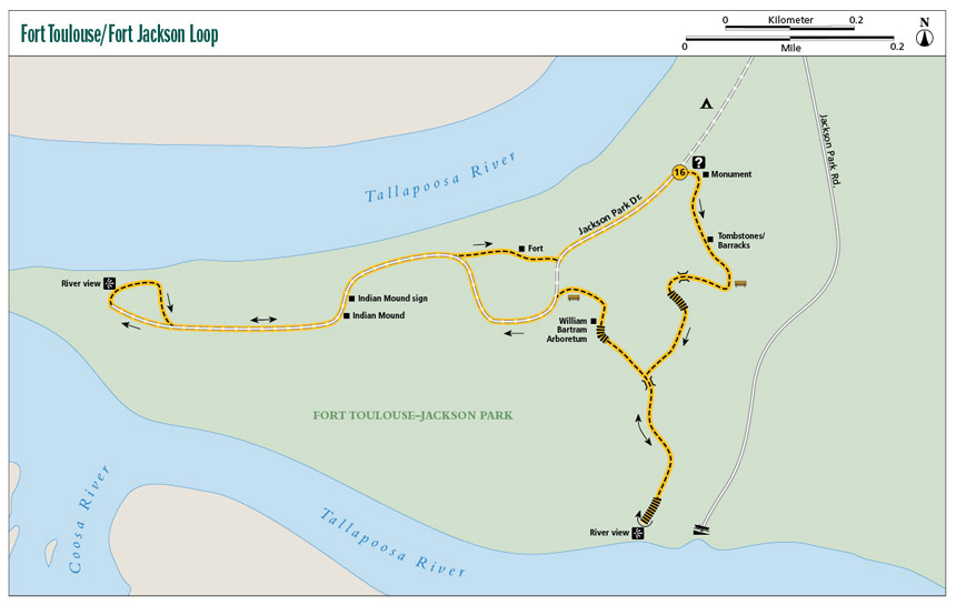
16 Fort Toulouse / Fort Jackson Loop
A beautiful blend of history and Southern landscapes will be found on the Fort Toulouse / Fort Jackson Loop trail as you walk among beautiful oak trees adorned with thick blankets of Spanish moss; visit the wide Tallapoosa River; retrace the steps of William Bartram, Botanist to the Queen; and visit the site of the historic fort itself.
Start: Parking lot in front of visitor center
Distance: 2.0-mile multiloop
Hiking time: About 1.5 hours
Difficulty: Easy over rolling hills
Trail surface: Dirt and crushed gravel trail, some dirt road and boardwalks
Best seasons: Sept–May
Other trail users: Cyclists on dirt roads
Canine compatibility: Leashed dogs permitted
Land status: Alabama historic state park
Nearest town: Wetumpka
Fees and permits: Day-use fee
Schedule: Year-round, dawn to dusk; visitor center open 8 a.m.–5 p.m.; closed Thanksgiving, Christmas Day, and New Year’s Day
Maps: USGS Wetumpka, AL; DeLorme: Alabama Atlas & Gazetteer, page 45 C8
Trail contact: Fort Toulouse / Fort Jackson National Historic Park, 2521 W. Fort Toulouse Rd., Wetumpka, AL 36093; (344) 567-3002; www.forttoulouse.com
Finding the trailhead: From Wetumpka at the intersection of AL 112 (W. Bridge Street) and AL 111, take AL 111 south 0.2 mile and turn right onto S. Main Street. Travel 0.8 mile and turn right onto AL 9 South. Travel 0.3 mile and turn left onto Old Montgomery Highway. In 0.8 mile turn right onto Fort Toulouse Road. In 3.4 miles you will arrive at the park entrance. Pay your day-use fee at the entrance kiosk or to the guard on duty and continue straight another 0.2 mile. The visitor center parking and trailhead is on the left. GPS: N32 30.335' / W86 15.170'
The Hike
Of all the historic hikes I have included in this and the previous three editions, Fort Toulouse / Fort Jackson has to be the one with the most diverse modern history crammed into one park.
The history of this plot of land begins around 5,000 BC, when bands of nomadic hunters roamed the region. Native Americans settled the area permanently during what is known as the Mississippian period (AD 1100–1400). Here on this fertile land rich in wildlife at the confluence of three rivers they built a society. Several mounds were constructed from mud, sticks, and branches that were used for ceremonies and as temples. One of those mounds, which this trail will lead you to, still exists and is dated as being built during this time.
The first European to arrive in the area was Hernando DeSoto in 1540. By the 1700s the French and British were making moves to control this new world. The French, wanting to halt the advance of Britain, decided to build a fort on the eastern side of the Louisiana Colony and, by invitation of their trading partners in good standing, the Creek Indians, built the first fort, Fort Toulouse (named after the son of King Louis XIV), on this spot.
In 1763 when the French and Indian War came to an end, with the French ending up on the losing side, France was forced to turn much of its territory over to Britain, including the fort. Britain was forced to abandon the fort soon after because the Creek Indians, loyal to the French, wouldn’t let them man it. Eventually the fort fell into disrepair and was reclaimed by nature.
In 1776 Botanist to the Queen William Bartram explored this area. After finding the ruins of the fort and seeing rich land and its proximity to the rivers, he wrote in his journals that the area was the “most eligible situation in the world for a city.”
A single log cabin is all that remains of the original Fort Toulouse from the mid-1700s.
During the War of 1812 after the battle of Horseshoe Bend, General Andrew Jackson came to this same location and established an earthen fort. He later began a campaign here against the British and Spanish armies, which culminated in the Battle of New Orleans in 1815.
Whew, that’s a lot of history! To learn more, stop by the visitor center at the fort to take a look at the exhibits and pick up a book or two on the long, rich history of this land.
The trail begins on the south side of the visitor center on a wide crushed gravel footpath but soon turns into a 2- to 3-foot-wide dirt footpath. This is the nature trail portion of the hike, and for the first 0.8 mile you will find yourself wandering through a beautiful floodplain forest. A floodplain forest occurs in the drainages of black-water rivers like you find here where the Tallapoosa and Coosa Rivers join to make the Alabama River.
The floodplain creates a rich, fertile environment for plants and wildlife. Some of the many species of trees you will come across include southern red, water, and laurel oaks; flowering dogwoods; yaupon holly; sweet gum; and Atlantic white cedar. Catch the trail in early to late spring for wildflowers like black-eyed Susans. Wildlife that may cross your path on this hike include mallard ducks, red fox, and white-tailed deer. Plus, Fort Toulouse / Fort Jackson is a stopover for the monarch butterfly.
Now, keep in mind what “floodplain” means. The trail gets a little muddy after a good rain, especially at mile 0.5 when you come to your first view of the river. The trail winds its way around many bogs, so be prepared for mosquitoes if you hike it in the warmer months. The loop eventually opens on a bluff to beautiful views of the confluence of the Tallapoosa and Coosa Rivers.
On the leg back to the trailhead, you will come to the site of the original fort itself. You can quite clearly make out where the diamond-shaped corners of the fort once stood, see the earthworks of a later reincarnation of the fort, and in the center visit a rustic building of the period.
Miles and Directions
|
0.0 |
Start at the trailhead from the south side of the parking lot. In 50 feet pass a monument to Jean-Louis Fonteneau, a sergeant in the French Colonial Marines who died at the fort in 1755. |
|
0.1 |
A short side trail to the left (east) takes you to two tombstones. Continue straight ahead to the south and cross a creek over a wooden footbridge. After crossing, come to a Y; take the left fork to the southeast. |
|
0.2 |
Come to a wide deck with informational signs and benches. In less than 0.1 mile, cross a seasonal creek over a 60-foot wood bridge with steel railings. In 200 feet come to a T intersection; turn left (west). |
|
0.3 |
Come to another deck with informational signs and benches. Head down a flight of stairs to the south. You will leave the crushed gravel path at the bottom as the trail becomes a dirt footpath. It’s very green and lush through here in late spring and early summer. In less than 0.1 mile come to another T intersection. Turn left (south). In 100 feet cross another seasonal stream over a footbridge. |
|
0.4 |
Come to a Y. A boat launch is to the left (east). Take the right fork to the south (a sign here points the way to the waterfront). |
|
0.5 |
Head down a series of railroad tie stairs and cross a boggy area (could be fairly deep after a good rain). Continue straight to the southwest. In 100 feet arrive at your first look at the Tallapoosa River. When ready, turn around and head back to mile 0.4. |
|
0.6 |
Arrive back at the Y at mile 0.4. Take the left fork. |
|
0.7 |
Take a series of wooden stairs up to a large deck. |
|
0.8 |
Arrive at the top of the stairs, with a large deck with signage describing the William Bartram Arboretum. Turn left (north) onto a short crushed gravel path. In 175 feet the trail ends at a gravel area with benches. You will see the fort to the right (northwest). Head west until you come to a dirt road. In 100 feet turn left (southwest) onto the dirt road and follow it around to the north. There are excellent views of the fort and the diamond shape of the structure along the route to your right. Beautiful Spanish moss–laden trees line the route on your left. |
|
1.0 |
The road bends to the left (west). A large sign points the direction to the Indian mounds. Follow the dirt road to the west. |
|
1.1 |
Come to an Indian mound on the right marked by a large sign reading “Mississippian Phase Mound Circa 1100–1400 AD.” You can move off-trail and explore the area, then continue on the dirt road. The road turns into mostly grass as you follow the edge of a large field. |
|
1.2 |
The path ducks back into the thick forest. |
|
1.3 |
Cross a dirt road to the northwest. |
|
1.4 |
Come out on an open bluff overlooking the river. There is a bench here. Turn right (northeast) and follow the grassy path around, making a small loop back to mile 1.3. |
|
1.5 |
Return to the dirt road and turn left (east) to head back to the fort. |
|
1.8 |
At the Indian mound sign you passed at mile 1.1, get off the road and head straight (northeast) toward the fort on an unmarked grassy path. In just over 200 feet, arrive at the log cabin that was once part of the fort. After exploring, head straight from the fort to the east and return to the dirt road. |
|
1.9 |
Arrive at the dirt road. Turn left (northeast) onto the road and head back to the trailhead. |
|
2.0 |
Arrive back at the trailhead. |
Hiking Information
Local Information
City of Wetumpka, 408 S. Main St., Wetumpka, AL 36092; (334) 567-5147; www.cityofwetumpka.com
Local Events/Attractions
French and Indian War Encampment, 2521 W. Fort Toulouse Rd., Wetumpka; (334) 567-3002; www.forttoulouse.com. Held annually the third weekend of April, reenactors portray French marines, English soldiers, and Creek warriors from the war (also known as the Seven Years War) for control of the eastern United States.
Accommodations
Fort Toulouse / Fort Jackson Campground, 2521 W. Fort Toulouse Rd., Wetumpka; (344) 567-3002; www.forttoulouse.com. Improved tent camping is available.
Restaurants
Must Stop Cafe, 60 Village Loop, Wetumpka; (334) 567-9955; www.muststopcafe.com. Southern food and homemade desserts.