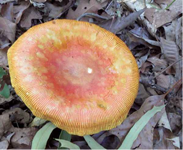
Colorful mushrooms grow all along the Overlook Loop.
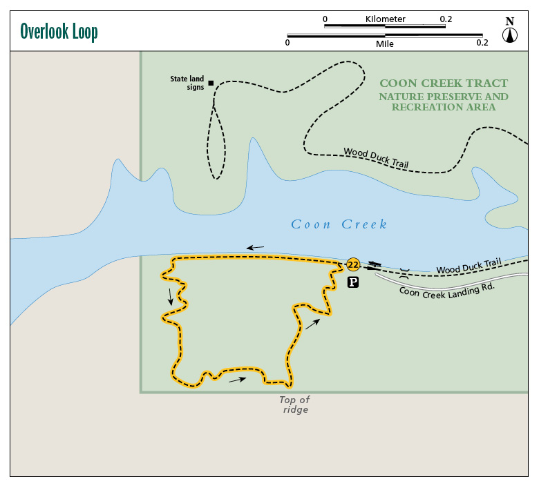
22 Overlook Loop
The Overlook Loop on the Forever Wild Coon Creek Tract is best experienced in the early fall when the leaves of the hardwoods are at their peak and in winter when the leaves drop, leaving you with a beautiful view of Coon Creek below. The climb up is a rather steep one, but with a series of switchbacks and its short distance (only 1 mile), the hike is made much easier.
Start: Kiosk on west side of boat ramp
Distance: 1.0-mile loop
Hiking time: 1–1.5 hours
Difficulty: Moderate due to short elevation gain
Trail surface: Dirt and rock
Best seasons: Year-round
Other trail users: None
Canine compatibility: Leashed dogs permitted
Land status: State wildlife management area
Nearest town: Tallassee
Fees and permits: None
Schedule: Year-round, sunrise to sunset
Maps: USGS McCalla, AL; DeLorme: Alabama Atlas & Gazetteer, page 46 A2; online at www.alabamaforeverwild.com
Trail contact: Alabama State Lands ADCNR, 64 N. Union St., Montgomery, AL 36130; (334) 242-3484; www.alabamaforeverwild.com
Finding the trailhead: From Tallassee at the intersection of AL 14 / E. Barnett Avenue and AL 229 / Jordan Avenue, take AL 14 east 2.3 miles. Turn left onto Macedonia Road and travel 3.1 miles. Turn left onto Hicks Store Road and travel 1 mile. Turn right onto Gravel Pit Road and in 400 feet turn right onto Coon Creek Landing Road. Follow the road to the boat ramp / parking area. The kiosk and trailhead is on the left (west) side of the parking lot. GPS: N32 35.838' / W85 52.831'
The Hike
The Tallapoosa River flows from the Appalachian Mountains in Georgia some 265 miles until it merges with the Coosa River. Several sections along its route have been dammed, creating a number of lakes and reservoirs. Near the town of Tallassee the Yates Dam was constructed to provide power to the region. A side benefit to the dam was the creation of recreational opportunities in the area, in particular boating and fishing on Yates Reservoir.
In February 1995 the Alabama Forever Wild program purchased a 320-acre tract of land along the banks of a feeder creek to the river, Coon Creek, to provide environmental education as well as recreational opportunities such as fishing, hunting, boating, and paddling. In 2009 the agency added to those recreational possibilities by opening two hiking trails here: the Wood Duck Trail and this trail, the Overlook Loop.
This aptly named 1-mile loop takes you high above the creek for some impressive views. Late spring through summer the foliage is thick so the view is obscured, but in late fall and winter it’s really nice. In the spring the white flowering dogwoods brighten the way. All along the route you will see a wide variety of mushrooms and fungi like turkey tail, plus wildflowers including trillium, silver bells, and hypatia.
Colorful mushrooms grow all along the Overlook Loop.
The path is a dirt bed that is well groomed no matter what time of year it is. Late spring through summer the thick foliage gives the route a nice enclosed feel (and the shade is welcome in the dog days). The trail is marked with a single red paint blaze, making this an easy trail to follow.
The Overlook Loop trail starts at the kiosk on the west side of the well-used boat ramp. There is a large topo map of the tract’s two hiking trails in the kiosk. Now, don’t be scared: Looking at the map of the Overlook Loop, it looks like this is going to be one long and steep climb to the top. Actually, the trail builders put in a good amount of switchbacks, and the climb is much easier than you would expect.
Your hike actually begins along the southern banks of Coon Creek. Throughout the first 0.2 mile you will be right next to the creek. If you like to fish, you might want to bring a pole so that after your hike you can wet a line for some spotted bass. As for wildlife, you are most likely to see white-tailed deer and wild turkeys, and along the creek, wood ducks.
Miles and Directions
|
0.0 |
Start on the left side of the informational kiosk and head west. The trail is marked with single red paint blazes. In just a few feet, cross a 20-foot bridge over a stream that feeds the creek. You may see some termite mounds here. You will be walking only a few feet from the banks of the creek. In 300 feet come to a Y. The left fork is the return path. Go straight to the west. There are two nice, short side trails to the banks of the creek just after the Y. |
|
0.2 |
The trail turns uphill and uses a series of switchbacks to make the trek easier. You will have nice views of the creek in late fall and winter and will see boat sheds and boats plying the waters. There are lots of mushrooms and wildflowers through here. |
|
0.7 |
Arrive at the top of the hill. Once again there are very nice views from late fall through winter. |
|
1.0 |
Arrive back at the Y that completes the loop. Turn right (east). In 300 feet arrive back at the trailhead. |
Hiking Information
Local Information
Elmore County Economic Development, PO Box 117, Wetumpka, AL 36093; (334) 514-5843; www.visitelmoreco.co
Local Events/Attractions
Wetumpka River and Blues Festival; (334) 567-5147; www.riverandblues.net. Held annually in mid-June along the Coosa River walk in downtown Wetumpka, the event features the hottest blues and jazz bands in the region.
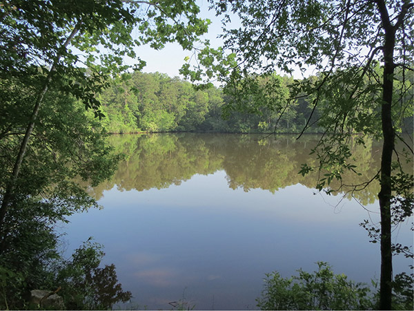
The north shore of Coon Creek is reflected in its placid early morning waters.