Maggie’s Glen is a great place to picnic and take in the sounds of the babbling stream.
28 Maggie’s Glen Loop
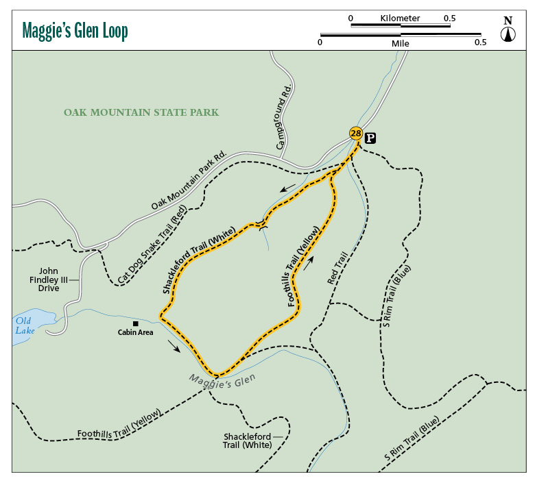
The Maggie’s Glen Loop at Oak Mountain State Park is an easy 2.2-mile trek that takes you alongside a nice, sparkling—but seasonal—stream to the glen that is located in a hollow. The glen is a perfect spot for picnicking, especially in the spring with the stream cascading next to the trail and white beeches and dogwoods flowering around you.
Start: North Trailhead on Oak Mountain Park Road
Distance: 2.3–mile lollipop
Hiking time: 1.5 to 2 hours
Difficulty: Easy on the White Trail, moderate climbs on the Yellow Trail
Trail surface: Dirt and rock
Best seasons: Winter–late spring
Other trail users: Cyclists
Canine compatibility: Leashed dogs permitted
Land status: State park
Nearest town: Pelham
Fees and permits: Day-use fee
Schedule: Year-round, sunrise to sunset
Maps: USGS Chelsea, AL; DeLorme: Alabama Atlas & Gazetteer, page 31 G7; trail maps available at entrance gate or camp store
Trail contact: Oak Mountain State Park, 200 Terrace Dr., Pelham, AL 35124; (205) 620-2524; www.alapark.com/oakmountain
Finding the trailhead: From Pelham on I-65 at exit 248, take AL 119 South / Cahaba Valley Road 0.2 mile and turn left onto Oak Mountain Road. Travel 1.9 miles and turn left onto John Findley III Drive. In 0.3 mile you will arrive at the entrance gate, where you pay your day-use fee. Continue straight (northeast) 5.8 miles on John Findley III Road. Watch for the many cyclists on the road. The trailhead is on the right side of the road and well marked. Parking is on the left. GPS: N33 21.453' / W86 42.285'
The Hike
If you are looking for a fun and relaxing walk in the woods or if you would like to introduce your family to hiking, take a hike on the Maggie’s Glen Loop at Oak Mountain State Park near Birmingham.
This beautiful little 2-mile loop follows alongside a nice stream that flows down from a hollow and Maggie’s Glen. The stream tumbles down a rocky bed, making small cascades. There are several short (10- to 20-foot) side trails that take you to its banks, so you can take a look and maybe dip your feet in.
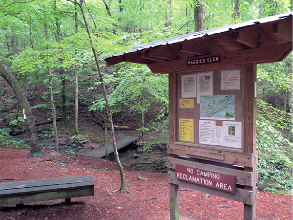
The trail’s namesake Maggie’s Glen is at the halfway point of the trip. There are several benches here thanks to local Eagle Scouts and access to the stream. This is a great place to just sit and take in the soothing sounds of the rushing water. It’s also a good place to bring along a picnic lunch and let the kids run around and enjoy the forest. There is an informational kiosk here that provides plenty of information about the local wildlife.
Speaking of which, along the trail you are very likely to meet up with eastern gray and fox squirrels darting from tree to tree, white-tailed deer, or wild turkeys. Listen carefully and you may hear the sounds of the yellow-billed cuckoo or pine warbler.
The forest itself is a mix of hardwoods like oak and hickory trees, as well as your usual southern pine trees including longleaf and loblolly. Maggie’s Glen is especially beautiful in early spring when the flowering dogwoods and white beeches bloom.
Maggie’s Glen is a great place to picnic and take in the sounds of the babbling stream.
The trail begins at the park’s North Trailhead. The trailhead will be on your right as you drive up the main park road, with a very large gravel parking lot on the left. There is plenty of parking for thirty or so cars, and it’s a good thing since this is the main trailhead for several trails used not only by hikers, but by cyclists and runners as well. The parking area has a nice portable toilet and a little something extra: a his-and-hers changing room.
The trailhead is the starting, or ending, point for several of the park’s trails. When you first set out, you will be walking on a combination of the Red (bike), White, and Yellow Trails. The trails are so-named because of their blazing. Shortly after setting out, you will turn off the Yellow/Red Trail and onto the White Trail. A sign here clearly marks the turn.
The trails are very well blazed, and it’s virtually impossible to get lost. The blazes are reflective markers the same color as the trail you are on—white, yellow, etc. Along the route you will pass 4-by-4 posts painted the same color as the trail you are on that have numbers on them. The numbers correspond to mileages on the trail, sort of like mile markers along the highway. If you get lost or in trouble, you can call the park ranger and tell them you are on, for example, the “White Trail at [or near] marker 59” and they can easily come to your rescue.
This loop actually uses two different trails—the White Trail and the Yellow Trail—to complete the loop. The White Trail from the North Trailhead to Maggie’s Glen is 1 mile long, level, and easy walking, so if you have younger children, you can take the easy route back by skipping the loop and simply retracing your steps to the trailhead.
The Yellow Trail includes some moderate climbs which you will immediately encounter as you leave Maggie’s Glen. It is a short but steep climb up to a ridgeline. In the winter when the leaves are down, you will be able to catch a view of the ridge across the valley.
Several trails intersect at Maggie’s Glen, and it can be a little confusing. There are directions and mileages posted on the kiosk to help out. If that doesn’t help, keep this in mind: As you face southwest toward the different trail signs, you will see the Yellow Trail sign and blazes on your left. That’s the way to go.
Miles and Directions
|
0.0 |
Start from the parking lot and cross the street to the North Trailhead (there are obvious signs here). One sign shows the distances to Peavine Falls (6.2), Peavine Trail (5.3), and South Trailhead (6.5). Go straight to the south. The trail starts as a 10-foot-wide gravel path and is actually three trails: the Red, the White, and the Yellow. In 400 feet the Red Trail (a 16-mile bike loop) splits off to the right. |
|
0.1 |
Take the right fork at a Y (a sign shows that this is the way to Maggie’s Glen), crossing a runoff ditch on a short footbridge. The trail is now a narrow dirt footpath. |
|
0.2 |
Come to a Y. The left fork is our return trip on the Yellow Trail. Take the right fork to the west on the White Trail. |
|
0.4 |
Pass white mile marker 27, then cross a stream over a 15-foot bridge. |
|
0.5 |
You will be walking next to a creek on the right and will cross it over a footbridge in a few feet. |
|
0.6 |
Pass white marker 28. |
|
0.8 |
Pass white marker 29. |
|
0.9 |
Come to a Y. A sign here points the way to cabins to the north (back the way you came) and Maggie’s Glen to the left. Take the left fork. |
|
1.0 |
The trail begins to parallel a wide stream on the right with nice cascades. |
|
1.1 |
Pass a short side trail to the stream on the right (nice cascades here). Pass white marker 30 and in 50 feet pass another side trail to the stream. |
|
1.2 |
Come to a sign pointing the direction of the White Trail. There is a rock jumble with the stream and cascades to the right. The trail narrows to 1½ to 2 feet wide, with a short drop to the stream on the right and an uphill slope on the left. In 200 feet you will arrive at Maggie’s Glen. There is an informational kiosk and four benches here, along with a three-prong fork in the trail: the Red-Yellow Connector (center), the Yellow Trail (left), and the White/Yellow Trail (right, to the south, with a bridge crossing the stream). Take the left fork uphill on the Yellow Trail. The blazes are now yellow. |
|
1.3 |
Pass yellow marker 81. This is a climb to the top of a ridge on the uphill side of the Maggie’s Glen stream (which is now on your left). Nice views along this ridge in the winter. |
|
1.6 |
Pass yellow marker 82. |
|
1.8 |
Pass yellow marker 83. |
|
2.1 |
Pass yellow marker 84. In 100 feet you will be back at the intersection with the White Trail at mile 0.2. Turn right onto the White/Yellow Trail and retrace your steps to the trailhead. |
|
2.3 |
Arrive back at the trailhead. |
Hiking Information
Local Information
Greater Birmingham Convention and Visitors Bureau, 2200 Ninth Ave. North, Birmingham, AL 35203; (800) 458-8085; www.birminghamal.org
Local Events/Attractions
Vulcan Park and Museum, 1701 Valley View Dr., Birmingham; (205) 933-1409; www.visitvulcan.com. The statue of Vulcan, the Roman god of the forge, is the world’s largest cast-iron statue and a fitting tribute to this iron and steel city. You can climb the 100-plus-year-old statue for a beautiful view of the city and also visit the interactive museum that tells the statue’s story and the history of the Magic City’s iron industry.
Lodging
Oak Mountain State Park Campground, 200 Terrace Dr., Pelham; (205) 620-2527; www.alapark.com/oakmountain/camping. Primitive and improved campsites.
Restaurants
Purple Onion Deli and Grill, 2296 Pelham Pkwy., Pelham; (205) 403-8600

Cyclists and hikers share the first section of the Maggie’s Glen Loop.