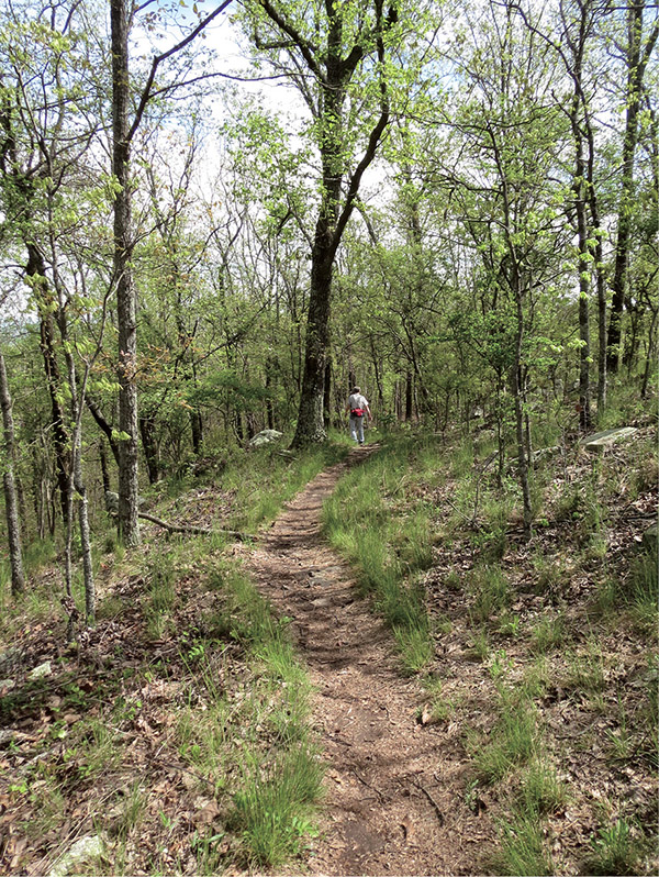
A portion of the Peavine Falls Loop follows just below the ridgeline of a hill.
30 Peavine Falls Loop
The Peavine Falls Loop Trail uses sections of three of Oak Mountain State Park’s popular hiking trails to take you to its centerpiece, Peavine Falls, a 65-foot tumbling cascade into a beautiful stony gorge. While the trail has steep climbs downhill, it is still a popular route most any time of the year, with its lush forest and, of course, the waterfall itself.
Start: Northwest side of parking area at Peavine Falls trailhead
Distance: 1.6-mile loop
Hiking time: 2 to 2.5 hours
Difficulty: Moderate with a steep downhill
Trail surface: Dirt and rock path, gravel road
Best seasons: Winter–early summer
Other trail users: None
Canine compatibility: Leashed dogs permitted
Land status: State park
Nearest town: Pelham
Fees and permits: Day-use fee
Schedule: Year-round, sunrise to 1 hour before dark
Maps: USGS Chelsea, Helena, AL; DeLorme: Alabama Atlas & Gazetteer, page 31 G6; trail maps available at entrance gate or camp store
Trail contact: Oak Mountain State Park, 200 Terrace Dr., Pelham, AL 35124; (205) 620-2524; www.alapark.com/oakmountain
Finding the trailhead: From Pelham on I-65 at exit 248, take AL 119 South / Cahaba Valley Road 0.2 mile and turn left onto Oak Mountain Road. Travel 2.7 miles and turn right onto Peavine Falls Road. Follow the winding road 3 miles to the parking lot. Be careful on the winding turns and watch out for bicycles. The Green Trail trailhead is on the northwest side of the parking lot. GPS: N33 18.155' / W86 45.735'
The Hike
Hundreds of people flock to Peavine Falls each weekend to view this 65-foot beauty that cascades down a sheer rock wall into a clear pool. It’s not quite true that all trails at Oak Mountain State Park lead to Peavine Falls, but many do. First there is the Green Trail, a rugged 1.9-mile climb up a ridge that starts at the park office along Terrace Drive. You can also follow the White or Blue Trails from the north trailhead on John Findley III Drive to reach the falls. Both of these trails are long hikes, each over 6 miles one way, that require either a shuttle or a long walk back to your vehicle.
An alternative is this little gem, the Peavine Falls Loop. The loop uses a section of all three trails for some ridgetop views, wildflower viewing, creek-side cascades, and, of course, the falls themselves.
The loop begins at the Peavine Falls trailhead. This is a large gravel lot capable of holding a good hundred cars (which shows you the popularity of the falls). There are two information kiosks here—one on the east side where the loop will return, the other on the northwest side where we begin the hike—along with a nice, clean portable toilet.
The drive up to the trailhead is on Peavine Falls Road, a long and winding dirt road that you will be sharing with cyclists. They cross the road several times on the Red Trail and other connector trails or use the road to ride up to the parking area. Just be watchful of the cyclists as you make your way around the sharp bends.
The trail itself is a combination dirt and rock footpath for most of its length, with the exception of the last 0.4 mile to the parking area where it is a wide dirt and gravel road. Your hike begins with a steady climb to the top of a ridge where dogwoods bloom in the spring and the live oaks and silver maples paint a brilliant picture in the fall. In the winter with the leaves down, you will catch a few views of the surrounding hills. Also along the ridge you might hear the sounds of yellow-billed cuckoos and pine warblers. In the summer thrushes and wrens dart through the brush, and throughout the year broad-winged and red-shouldered hawks soar overhead.
A portion of the Peavine Falls Loop follows just below the ridgeline of a hill.
At mile 0.6 you will take the Green-White Connector Trail to the White Trail. This is a very steep and rocky descent to the banks of a good-size creek, Peavine Creek, where you’ll turn to the southwest and follow alongside the creek on the White Trail. The creek is fast flowing, with some nice cascades from fall through spring with seasonal rains. In the summer the flow tapers off, but it’s still a nice companion along this section. It won’t be long before you hear the sounds of the falls in the distance.
Soon you make a left turn to the east and take the Blue Trail to the falls themselves. The trail is very rocky and narrow here. You have two options at this point: You can go to the right and head to the bottom of the falls and a nice, clear, cool pool or go to the left and take in the tumbling waters and the gorge from high above. The trek I describe here takes the upper route, but either way is well marked and well worth the effort. If you go to the upper falls, your best views will come winter to early spring when the leaves are down.
Be warned, however, that the cliffs and bluffs around the falls are slick and the drop is precipitous. Use extreme caution in this area. Not doing so could result in severe injury or death.
All of the trails used have plenty of blazes to help keep you on track. Each blaze is a rectangular reflective marker in the color of the trail (even the Green-White Connector). You will also pass several 4-by-4 posts along the trail. These are painted the same color as the trail name and are numbered. The numbers correspond to mileages on the trail, sort of like mile markers along the highway. If you get lost or in trouble, you can call the park ranger and tell them you are, for example, on the “Green Trail at [or near] marker 59” and they can easily come to your rescue.
While overnight backcountry camping is permitted along several trails in the park, it is not allowed in the areas just above and below the falls. Also, rappelling and climbing are not allowed on the rock walls of the gorge.
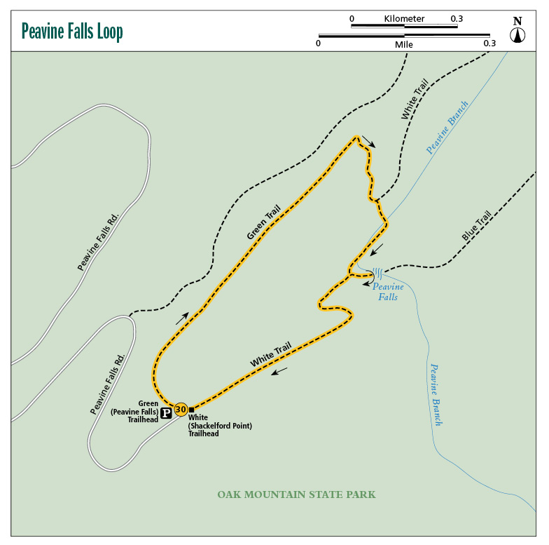
Miles and Directions
|
0.0 |
Start from the Peavine Falls trailhead on the northwest side of the Peavine Falls parking lot. There is a kiosk here with general trail information and a park trail map. The trail is marked with green reflective markers. In a few yards you will pass your first numbered trail post; it is green with the number 60. The trail starts uphill on a wide, 4-foot gravel bed through a thick pine forest. Not far in, the trail narrows to a 2-foot-wide dirt path. After a short climb, the trail levels out and follows the level ridgeline. |
|
0.1 |
Pass the Green-Red Connector Trail on your left (northwest). Continue straight (northeast) on the Green Trail. Lots of grass lines the sides of the trail, and the bed is a bit rockier at this point. (FYI: Excellent wooden signs indicate all trail intersections.) |
|
0.2 |
Pass another green marker, 59. There are some views through the trees as you walk the ridgeline. In the spring this section is lined with cardinal flower. |
|
0.4 |
A short, 15-foot trail to right (southeast) leads to the top of the ridge for a view of the valley. |
|
0.5 |
Pass trail post #58. |
|
0.6 |
Come to an intersection. Turn right (north) here onto the Green-White Connector Trail. The trail is blazed with green and white reflectors, and it is very steep and rocky. Mostly hardwood trees line this section. |
|
0.8 |
Come to a T intersection. The White Trail heads to your left and right (northeast/southwest). Turn right (southwest) onto the White Trail. The trail is now marked with white paint blazes or reflective markers. A fast-flowing stream (depending on rainfall) will be on your left (southeast) through this section. The path is level with rocks, dirt, and tree roots. |
|
0.9 |
Pass white marker 50. In less than 0.1 mile, come to an intersection with the Blue Trail; a sign here says “Falls/Blue Trail” with an arrow pointing left (east) and “Parking Lot” with an arrow point straight ahead (southwest). Turn left onto the Blue Trail, crossing the creek over a footbridge. In 100 feet come to a sign that reads “Top of Falls” with an arrow pointing left (east) and “Bottom of Falls” with an arrow pointing right (southeast). For this hike I chose the top of the falls to the left, but feel free to explore either direction. Either way the path is very rocky and narrow, coming right up to the edge of the cliff. Use extreme caution! (A sign here reads “Peavine Falls Area. Caution—Rocky, Steep, Dangerous. Enter at Your Own Risk.”) |
|
1.0 |
Arrive at the top of the falls. Again, use caution! It’s dangerously close to the edge of the cliff. When you’re ready, turn around here and head back the way you came. |
|
1.1 |
Return to the intersection with the White Trail at mile 0.9. Turn left (southwest) onto the White Trail. The trail soon changes from a dirt path into a wide gravel road that winds its way steeply uphill. Benches are available for resting at each bend. |
|
1.6 |
Arrive at the Peavine Falls parking lot. You will be on the east side of the lot across from the Green Trail where you originally started. |
Hiking Information
Local Information
Greater Birmingham Convention and Visitors Bureau, 2200 Ninth Ave. North, Birmingham, AL 35203; (800) 458-8085; www.birminghamal.org
Local Events/Attractions
Birmingham Barons Baseball, 1401 First Ave. South, Birmingham; (205) 988-3200; www.milb.com/index.jsp?sid=t247. The Birmingham Barons minor league (Southern League) baseball team has been around since 1885 and has produced many stars over the years, including Reggie Jackson and Rollie Fingers.
Lodging
Oak Mountain State Park Campground, 200 Terrace Dr., Pelham; (205) 620-2527; www.alapark.com/oakmountain/camping. Primitive and improved campsites.
Restaurants
Johnny Ray’s, 2252 Pelham Pkwy., Pelham; (205) 989-7211. Great local barbecue.
Hike Tours
Oak Mountain State Park, 200 Terrace Dr., Pelham; (205) 620-2520; www.alapark.com/oakmountain/Nature%20Programs%20&%20Events. Oak Mountain State Park has naturalists that love to talk about nature within the park. Contact them for information about setting up a tour, or visit the website for a list of special tours and events.