
The Ike Maston Trail portion of this loop is rated “most difficult” by park officials.
31 Ike Maston–BMRR Loop
Red Mountain was once a major iron-ore mining area. Today the mountain has been reclaimed and is now a beautiful and popular park with a touch of history and lots of fun for visitors of all ages, including zip lines and rope bridges. The Ike Maston–BMRR Loop Trail is short but a bit challenging with moderate to difficult climbs. The trail leads you away from the crowds that usually pack the park and takes you to an impressive piece of mining history, the Redding Shaft Mine and Hoist House.
Start: Trailhead on Frankfurt Drive
Distance: 3.2-mile lollipop
Hiking time: About 2 hours
Difficulty: Moderate to difficult due to steep inclines
Trail surface: Dirt footpath, gravel road
Best seasons: Year-round
Other trail users: Cyclists, joggers on the BMRR Trail
Canine compatibility: Leashed dogs permitted
Land status: City park
Nearest town: Birmingham
Fees and permits: None; fee for Iron Ore Zip Line (reservations required)
Schedule: Year-round, sunrise to sunset
Maps: USGS Bessemer, Bessemer Iron District, Birmingham South, AL; DeLorme: Alabama Atlas & Gazetteer, page 30 F5; trail maps available at information kiosk (free but donation requested)
Trail contact: Red Mountain Park, 277 Lyon Ln., Birmingham, AL 35211; (205) 202-6043; www.redmountainpark.org
Finding the trailhead: From I-65 in Birmingham, take exit 255 and head west on W. Lakeshore Parkway. Travel 3.2 miles and turn right onto Frankfurt Drive. The trailhead is at the bend as Frankfurt Drive becomes Lyon Lane. Park anywhere along Frankfurt Drive. GPS: N33 26.712' / W86 51.753'
The Hike
Many people know that the city of Birmingham was once the center of iron production in the South. Parks such as Tannehill Ironworks Historic State Park allow you to hike that piece of the city’s history. But what many people do not realize is that to become the industrial powerhouse it was in the 1800s and the bustling city it is today, it took a little red dust—iron ore. Red Mountain Park gives hikers a chance to visit that part of the history and learn about the sweat and backbreaking work it took to bring the ore to market, plus there’s a little something extra. More on that in a moment.
The abridged story of iron ore in central Alabama goes back centuries to the Native Americans who lived in the region and used the dust for dyeing clothes and pottery. It wasn’t until the 1840s that a local farmer, Baylis Earle Grace, identified the dust as hematite (iron ore) and began scraping the land and shipping it to a foundry in a neighboring county. As the Civil War approached, speculators began buying up large tracts of land on and near Red Mountain, the goal being to capitalize on the now-burgeoning iron-mining industry. The area’s first commercial mine, known as Eureka 1, was opened in 1863 (the mine is located on the eastern side of the park). And with that the mining boom was on, the population increased, and in 1871 the city of Birmingham was founded.
The iron-mining boom continued for a century, until it was finally shut down for a variety of reasons, including an increase in foreign imports. The last active mine on the mountain was closed by its owner at the time, US Steel, in 1962. After that, Red Mountain stood virtually untouched until 2007 when—through the efforts of a neighbor of the mountain, Ervin Battain; the work of many volunteers; and an amazingly generous donation by US Steel of its 1,200 acres of land on the mountain—the vision to create a historic park was born.
Today Red Mountain Park is not only a testament to an industry that built a city, but also a beautiful nature preserve. The park boasts over 10 miles of hiking trails, most being dirt and rock footpaths with the remainder being old mining roads. The trails interconnect, allowing you to create your own loop adventures. The paths take you to two beautiful overlooks, three historic iron-mining structures and mines (which are sealed off), and some unique fun for you and your family. Red Mountain is the home of the Red Ore Zip Line, a fun and fast ride through the mountain’s canopy, and the SkyHy Treehouse, a platform high up in the trees that can be reached by rope bridges.
The Ike Maston Trail portion of this loop is rated “most difficult” by park officials.
The trailhead is located on a bend in the road where Frankfurt Drive becomes Lyon Lane. You can park anywhere along the side of Frankfurt Drive. (By the way, the park’s office is located less than a half mile away on Lyon Lane on the right.) The trail described here is a 3.2-mile lollipop loop that uses three trails: the Ike Maston Trail, a short section of the Songo Trail, and the BMRR South Trail.
The Ike Maston Trail is a dirt and rock path that is labeled as being “most difficult.” There are some pretty steep and long grades to tackle. The good thing about these climbs is that they take you away from the crowds that use the more level mining roads. The trail was named for one of the last miners to work on the mountain when it closed. (You can hear Mr. Maston tell his story in an oral history on the Red Mountain website, www.redmountain.org/park-overview/oral-history-project.) The BMRR South Trail is a nice, level path that was once a mining road that will lead you back to the trailhead.
The highlight of the hike is the Redding Shaft Mine and Hoist House that you’ll find near the intersection of the Songo and Ike Maston Trails. The mine, which has been sealed off, was a 400-foot-deep shaft mine that was in operation from 1917 to 1927. The electric-powered hoist house helped haul the ore from the mine and is a beautiful mission-style structure.
As I said, this is only one of many possible loop hikes in the park, but be forewarned: Be ready for some crowds on the weekend! This is one popular park. The facility regularly holds runs and walks for fun and charity, and it’s well used by the locals. On the day I visited, I had to park a good 0.75 mile from the trailhead on Frankfurt Drive.
 Alabama is the only state that has all of the natural resources to make iron and steel. And when it comes to production, the state is the largest supplier of cast iron and steel pipe in the country.
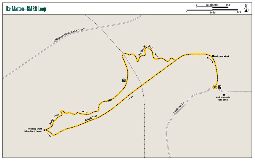
Miles and Directions
|
0.0 |
Start at trailhead at the bend in the road where Lyon Lane and Frankfurt Drive meet. The trail heads up a short hill to the northeast and then turns north. The path is a dirt and gravel road. |
|
0.2 |
Come to the welcome kiosk with information about the park and its trails. Maps are available here. Please drop a dollar or two into the lockbox for the map, and remember to pack it out with you. Two very nice portable toilets are located to the right. Turn left (west) here. The path is still a dirt and gravel road at this point and unmarked. |
|
0.4 |
Come to the intersection with the BMRR South Trail. Turn left (southwest) onto the BMRR. The trail continues to be a dirt and gravel road. In less than 0.1 mile, come to a sign indicating that the Ike Maston Trail is to the northwest and the BMRR continues to the southwest. Turn right (northwest) onto the unmarked gravel connector trail. |
|
0.5 |
A chain blocks the road to the north. Turn left (southwest) onto the Ike Maston Trail. Shortly after the turn, a small sign warns that the trail is “most difficult.” The trail is now a dirt footpath and begins a steady and steep climb. |
|
0.7 |
Cross an intermittent creek. The dirt has a red iron hue here. |
|
0.8 |
In a hollow to the left (southwest), you will see a clearing for a petroleum pipeline. |
|
0.9 |
Come to a sign indicating that the Smythe Trail connects from the left (south). In less than 0.1 mile, cross the petroleum pipeline clearing (the pipe is underground). |
|
1.1 |
There is a view of the valley to your left (east). |
|
1.2 |
Cross an intermittent stream with a stone water bar. After crossing, climb a hill to the west on some old wooden stairs made from railroad ties. |
|
1.6 |
The Songo Trail joins the Ike Maston Trail from the left (south). Continue straight to the northwest on the Ike Maston Trail. In a few hundred feet, cross a stream over a nice wooden bridge. |
|
1.7 |
Pass an old 4-by-4-inch cement post on the right. |
|
1.9 |
Arrive at the Redding Shaft Mine and Hoist House. There are interesting signs here telling the story of the hoist and the mine. Turn left (southeast) onto the Songo Trail, which is now a gravel and dirt road. In less than 0.1 mile, turn left onto the BMRR South Trail. A frog pond is here at the bend and the frog song is marvelous. (Option: At the Hoist House, continue straight on the Ishkooda Trail to visit the SkyHy Treehouse and Ishkooda Overlook, then follow the Smythe Trail back to mile 2.6 of the hike.) |
|
2.5 |
Cross the petroleum pipeline clearing again. |
|
2.6 |
Pass the Smythe Trail to the left (north). |
|
2.8 |
Pass the connector trail to the Ike Maston Trail to the left (north). |
|
3.0 |
Arrive back at the welcome kiosk. Turn right (south) onto the dirt and gravel entrance road and head back the way you came to the trailhead. |
|
3.2 |
Arrive back at the trailhead. |
Hiking Information
Local Information
Homewood Chamber of Commerce, 1721 Oxmoor Rd., Homewood, AL 35209; (205) 871-5631; www.homewoodchamber.org
Local Events/Attractions
Birmingham Barons Baseball, 2230 Second Ave. South, Birmingham; (205) 988-3200; www.milb.com/index.jsp?sid=t247. A storied baseball franchise, the Barons have been playing Southern League (minor league) baseball since 1885 and are currently an affiliate of the Chicago White Sox.
Restaurants
Hamburger Heaven, 180 Oxmoor Blvd., Homewood; (205) 941-1668
Hike Tours
The Friends of Red Mountain lead hikes for all skill levels the third Sunday of each month.
Organizations
Friends of Red Mountain, 277 Lyon Ln., Birmingham; (205) 202-6043; www.fws.gov/bonsecour/friends.htm