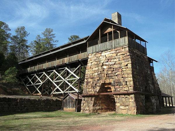
The main furnace at Tannehill fully restored
35 Tannehill Ironworks Historic Trail
The ironworks at Tannehill produced many iron implements used by the Confederate army during the Civil War. The forge, which was restored in 1976, is today the centerpiece of Tannehill Ironworks Historical State Park. The Tannehill Ironworks Historic Trail travels around the buildings of the ironworks and its furnace. Heading into the woods, the trail takes you to the rolling blue-green waters of Roupes Creek and the cemetery of the slaves who worked at the ironworks.
Start: Behind the Iron and Steel Museum of Alabama
Distance: 4.1-mile lollipop
Hiking time: 2–2.5 hours
Difficulty: Moderate due to some short climbs
Trail surface: Dirt and gravel
Best seasons: Year-round
Other trail users: Cyclists
Canine compatibility: Leashed dogs permitted
Land status: Alabama historic state park
Nearest town: McCalla
Fees and permits: Day-use fee; Iron and Steel Museum fee
Schedule: Year-round; day use sunrise to sunset; visitor center open Mon–Fri 8:30 a.m.–4:30 p.m., Sat 9 a.m.–4:30 p.m.; Iron and Steel Museum open Mon–Fri 8:30 a.m.–4:30 p.m., Sat 9 a.m.–4:30 p.m., Sun 12:30–4:30 p.m.
Maps: USGS McCalla, AL; DeLorme: Alabama Atlas & Gazetteer, page 30 H3; trail maps available at country store
Trail contact: Tannehill Ironworks Historical State Park, 12632 Confederate Pkwy., McCalla, AL 35111; (205) 477-9400; www.tannehill.org
Finding the trailhead: From the intersection of I-459 and I-20 West / I-59 South, take I-20 West / I-59 South 5 miles. Take exit 100 (Abernant/Bucksville) and turn left onto AL 216 East. (Shortly after turning onto AL 216, it becomes Bucksville Road.) Follow AL 216 / Bucksville Road 0.6 mile and make a slight right onto Tannehill Parkway. Travel 1.9 miles and turn right onto Eastern Valley Road. In less than 0.1 mile, turn left onto Confederate Parkway. The park entrance is ahead in 0.7 mile. GPS: N33 14.970' / W87 04.297'
The Hike
At one time Birmingham and its environs rivaled the steel-production machine of Pittsburgh and helped keep the Confederate army supplied with weapons. In 1830 Daniel Hillman came to Alabama from Pennsylvania and built a forge along Roupes Creek. Two years after setting up the operation and well before he had a chance to see the fortune the forge would make, Hillman died. Local farmer Ninian Tannehill purchased the forge.
Three tall furnaces were constructed on the site with the use of slave laborers who cut the sandstone bricks by hand. By 1862 the ironworks was in full swing, producing pig iron for the Confederacy. On March 31, 1865, the Eighth Iowa Cavalry of the US Army shelled and set fire to the foundry, while a few miles up the road, Union troops torched the slave quarters.
A businessman bought the ironworks after the Civil War and tried to rebuild it, but times during Reconstruction were bad, and the facility was eventually abandoned and soon overtaken by nature.
This brings us to the 1970s, when the state of Alabama and several colleges resurrected the site. Archeological digs uncovered the old blower house and the main furnace. The furnace was rebuilt to its former glory and is now listed on the National Register of Historic Places.
The historic park encompasses more than 1,500 acres of forest just south of Bessemer. Forty historic structures of the period (1830 to 1870) have been brought in and restored for the public to view. Local craftspeople demonstrate the making of quilts, furniture, and pottery at the site each year between March and November. But, of course, the restored furnace is the park’s centerpiece.
The main furnace at Tannehill fully restored
The Tannehill Ironworks Historic Trail takes you through the major sites of the park. The trail itself is actually a combination of four separate routes: the Iron Works Trail, Slave Quarters Trail, Old Bucksville Stage Road, and Iron Haul Road. Along its route the trail passes through thick oak and dogwood forests and alongside several creeks, including Roupes Creek, which once helped power the furnace.
We begin the hike at the Alabama Iron and Steel Museum, a great museum that exhibits many of the artifacts discovered through the years at the site and well worth the small admission. The trail begins directly behind the museum next to Plank Road, which features cabins from the mid to late 1800s.
After crossing a creek you will come to a Y intersection with three trails. The top trail simply loops back into the middle trail. The center trail leads you to the top of the furnace to take a look at the massive stone structure from above. Our walk uses the lower trail on the left, which is called the Iron Works Trail. The trail takes you along beautiful views of the creek, with several boiling rapids churning its blue-green waters, before taking you to the base of the furnace, an impressive sight. Take your time to stroll around the structure and take it all in.
As the trail moves into the woods away from the campgrounds, it joins the Slave Quarters Trail. You’ll have to look hard, but you will pass the foundations of several of the slave cabins burned by Union troops during their raid. The trail soon turns onto Old Bucksville Stage Road, which was the main highway into the area during the mid-1800s. At the end of the road, a short side trail leads to the slave cemetery. All that remains are simple, plain rock headstones marking the graves.
The hike is rated moderate due to some good inclines. The trail itself uses well-maintained dirt, gravel, and clay roads. After a good rain, however, some of the route, especially the Iron Road returning to the trailhead, can be deep in mud or have several water runoffs crossing it.
Your park day-use fee covers hiking, admission to the craft houses, and a visit to the furnace. The museum is a separate fee. And remember, artifacts are protected by the State of Alabama and cannot be removed. In other words, don’t take home a brick from the furnace.
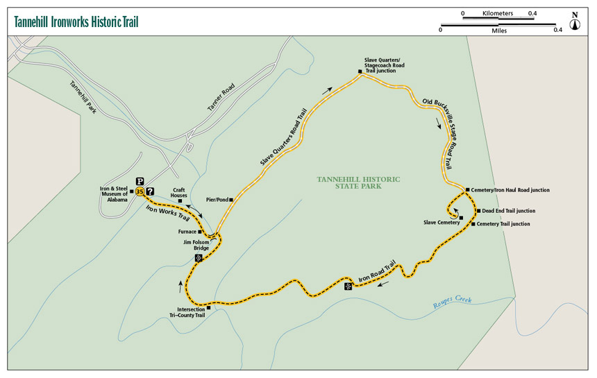
Miles and Directions
|
0.0 |
Start from behind the Alabama Iron and Steel Museum. Head down a set of cement stairs toward the creek to the southeast. Cross the creek on a small wooden bridge (a playground is on the opposite side of the creek on your right; a picnic area is to the left). There is a Y after the bridge. Take the left fork to the east (a sign here reads “Iron Works Trail”). This trail takes you behind the craft buildings and great views of the creek. |
|
0.4 |
Come to the furnace. Cross the creek to the left (east) over the wood and steel Jim Folsom Bridge. On the other side come to the intersection with the Iron Haul Road Trail. A sign here points to the left (northeast), showing the way to the cemetery and Stagecoach Road. Turn left here onto the Slave Quarters Trail. |
|
0.5 |
Pass a short pier that juts into a pond to the left (west). |
|
0.9 |
Cross a stream that flows under the road. |
|
1.2 |
Come to the intersection with the Old Bucksville Stage Road Trail. A sign here points to the cemetery (to the right) and furnace (the way you just came). Turn right (southeast) onto the Old Bucksville Stage Road Trail. |
|
1.9 |
Come to the intersection of the Iron Haul Road Trail and Cemetery Trail. Turn right (southwest) onto the Cemetery Trail. |
|
2.0 |
Arrive at the slave cemetery. A chain-link fence encircles the site. You can enter through a gate that is tied shut with a rope. (Option: From the cemetery the trail continues to the southeast another 0.1 mile, where it connects with the Iron Haul Road Trail [mile 2.3 below]. On my visit this section of trail was underwater with a runoff stream. I opted to turn around at the cemetery and return to the intersection of the Old Bucksville Stage Road and Iron Haul Road Trails.) |
|
2.1 |
Back at the intersection of the three trails, turn right (southeast) onto the Iron Haul Road Trail. |
|
2.2 |
Come to a Y. To the left (southeast) is a dead-end trail (and it’s marked as such). Take the right fork (south). |
|
2.3 |
Pass a side trail on the right (north). This is where the side trail from the cemetery joins the Iron Haul Road Trail. Continue straight (southwest). |
|
2.8 |
Start seeing good views of Roupes Creek to the left (south). |
|
3.3 |
A nice, grassy, 30-foot-long side trail leads to the banks of the creek. |
|
3.4 |
Pass the Tri-County Trail coming in from the right (north). Continue straight to the west. |
|
3.6 |
Good views of Roupes Creek to the left (west). |
|
3.8 |
Return to the Jim Folsom Bridge. Retrace your steps to the parking lot. |
|
4.1 |
Arrive back at the parking lot. |
Hiking Information
Local Information
Bessemer Area Chamber of Commerce, 321 N. 18th St., Bessemer, AL 35020; (888) 423-7736; www.bessemerchamber.com
Local Events/Attractions
Trade Days at Tannehill, 12632 Confederate Pkwy., McCalla; (205) 477-9400; www.tannehill.org. The third weekend of each month from March through November, Tannehill plays host to one of the largest arts and craft shows around. People come from around the country to purchase handmade items, jewelry, furniture, and more.
Lodging
Tannehill Ironworks Historical State Park, 12632 Confederate Pkwy., McCalla; (205) 477-9400; www.tannehill.org. Tannehill has an excellent campground with both primitive and improved sites. Reservations are not accepted, so get there early to get a good spot.