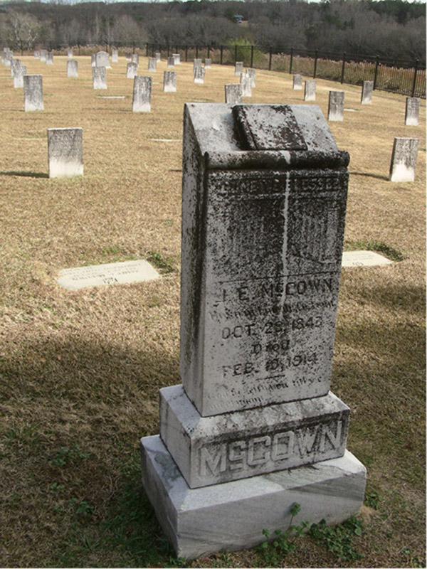
The trail leads to the solitude of Cemetery #2 where many of the veterans who lived here were buried.
36 Confederate Memorial Park Nature Trail
Once again we take you on a fascinating little hike that combines a nice interpretive nature walk, which features the second-largest yellow poplar tree in the state, with Civil War history—not history from the war itself but after it, as you walk around the grounds and remnants of a retirement home for Confederate soldiers.
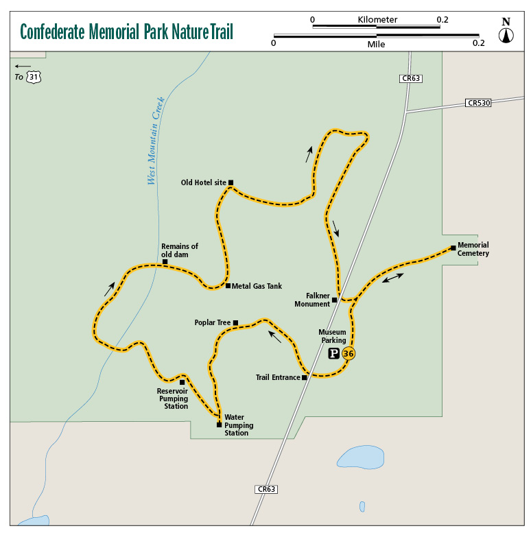
Start: Museum parking lot
Distance: 1.4-mile lollipop
Hiking time: 1–1.5 hours
Difficulty: Easy on wide, flat trail
Trail surface: Dirt and gravel, some pavement near end
Best seasons: Sept–May
Other trail users: None
Canine compatibility: Leashed dogs permitted
Land status: Alabama historic state park
Nearest town: Verbena
Fees and permits: None to hike; admission fee for museum
Schedule: Year-round; park open 6 a.m.–dark; museum open 9 a.m.–5 p.m.
Maps: USGS Marbury, AL; DeLorme: Alabama Atlas & Gazetteer, page 38 H1; brochures with trail map available at museum gift shop
Trail contact: Confederate Memorial Park, 437 CR 63, Marbury, AL 36051; (205) 755-1990; www.preserveala.org/confederatepark.aspx
Finding the trailhead: From exit 200 on I-65, take CR 59 south 2.4 miles. Turn right onto US 31 South. Travel 2.3 miles and turn left onto CR 23. Travel 0.7 mile and make a right onto CR 63. The park entrance is straight ahead in 0.5 mile. The museum and parking is on the right, just after the entrance. GPS: N32 43.122' / W86 28.449'
The Hike
Normally when we talk about a hike through a Civil War park, we talk about the battle that occurred there. This time, however, we’re talking about a time not too removed from the end of the war, when the veterans of the Confederate military needed help just to survive.
Confederate Memorial Park is the former site of the Alabama Old Soldiers Home. Following the war, several Southern states began an effort to help their veterans who could not support themselves. Hundreds, if not thousands, of former Confederate soldiers found themselves without family, jobs, money, land, or a place to live. Many had physical disabilities and lived in poorhouses. Unlike their Northern counterparts, who received fairly decent pensions from the federal government, Confederate soldiers had to rely on whatever they could to get by on.
In the late 1800s Montgomery attorney and Confederate veteran Jefferson Manly Falkner began a crusade to do something about this situation. Donating 80 acres of his own land, Falkner set out to build the Alabama Old Soldiers Home. Funds to construct and eventually run the facility came in from across the state, until finally the twenty-two-building facility, complete with a twenty-five-bed hospital, began operation in 1901. At its height, the facility housed 104 Confederate veterans and their wives. It ended operation in 1939, when the last remaining residents, five surviving widows, were placed into the care of the state welfare department. The buildings were soon dismantled and the land all but forgotten, except for the two cemeteries where the remains of many former residents are buried.
The land was resurrected by the state in 1964 when the Alabama legislature created Confederate Memorial Park, which, as they said, would be a “shrine to the honor of Alabama’s Citizens of the Confederacy.” Today the park is a fascinating look back in time at an era almost lost to history. The park boasts a beautiful museum that tells the story of the facility and its residents, and the trail here takes you not only to some interesting natural settings, but back to the time when the home was in full operation. There is no fee to enter the park or hike the trails, but there is a small admission fee to tour the museum.
The trail leads to the solitude of Cemetery #2 where many of the veterans who lived here were buried.
The trail itself is a myriad of fire lanes, old dirt and gravel roads, and dirt footpaths that wind their way around the grounds. There are several side roads you can take to visit other areas not described here, all following similar wide paths. While for the most part the trails are not marked, it’s difficult to lose your way since most loop back around toward the main path described there.
Before starting your hike, stop by the gift shop at the entrance of the museum for a brochure that describes some of the history you will be passing. Many of the features are numbered and correspond to a description in the handout.
The trail begins directly across the street from the museum. A sign reading “Nature Trail” leads the way through a wooden gate. One of the impressive bits of nature you will encounter on the trip is the second-largest yellow poplar tree in Alabama. When last officially measured, the tree had a circumference of 174½ inches and stood 105 feet tall. The canopy of the tree is 70 feet wide. You will also pass a spring that flows at a rate of 10 gallons per minute and was the source of water for the home.
As for the history, the trail will take you past the remains of an old dam built in 1905, the Old Marbury Methodist Church, and the site’s reservoir and pumping station. The reservoir is an impressive large white structure that held 85,000 gallons of water that was pumped to a tower and then pumped into the home.
The hike culminates with a visit to Cemetery #2, a beautiful and peaceful resting place atop a hill overlooking the valley. As you enter the gates of the cemetery, the first grave you will pass is that of Jefferson Manly Falkner himself, the man whose vision created this site to honor and care for Alabama’s Confederate veterans.
 Just what is Dixie? Shortly before the Civil War, the State of Louisiana issued a note of currency worth $10 called a dix—French for “ten”—and eventually the South became known as “Dixie.” Montgomery, Alabama, was the first capital of the Confederacy, and Alabama is officially known as the Heart of Dixie.
Miles and Directions
|
0.0 |
Start at the parking lot in front of the museum. (FYI: Be sure to pick up a brochure at the museum that lists the historic sites along the route.) Cross the road to the west. There is a wooden fence here with a sign that reads “Nature Trail”. The trail is a wide dirt footpath. |
|
0.1 |
Come to a sign that reads “Nature Trail” on the left and a trail leading in. Turn left (west) here onto a gravel footpath. Many signs dot the trail through this area identifying the plants you will see. In less than 0.1 mile, come to the second-largest poplar tree in the state on the right. It also happens to be the largest poplar in Lawrence County. |
|
0.2 |
Come to a Y in the trail. Take the left fork (south). In about 200 feet come to a T intersection. Turn left (south). |
|
0.3 |
Arrive at the remains of a water-pumping station. The trail veers to the right (northwest). |
|
0.4 |
Come to the remnants of a reservoir pumping station that was used to supply water to the facility in the early 1900s. Follow the trail around the white building and cross a stream on a wooden bridge. A small trail comes in from the right. Continue straight (southwest). |
|
0.5 |
Cross a wooden bridge over a spring. The trail parallels the stream to the right a short distance. Come to another T intersection. Take a right and head north. |
|
0.6 |
Pass the remains of an old dam and pond on the left. |
|
0.7 |
The trail returns to the dirt path that you started on. Turn left (north) onto the dirt path and pass a cylindrical metal gas tank on the right that was used for cooking and lighting at the home. |
|
0.8 |
Pass the site of the old hotel as the trail swings around to the north. You will be passing a grassy field on your left (north). The Old Marbury Methodist Church can be seen to your right. |
|
0.9 |
Turn right (east) onto a short, narrow 4-foot gravel path. In about 100 feet pass a picnic area and an old building used for gatherings on your left. Turn right (southwest) onto a dirt road and in a few yards you will pass the church. Continue straight (south) past the church on the dirt road to the paved park road (you are heading toward the museum). |
|
1.1 |
Pass by the J. M. Falkner monument and a stand of memorial cedars on the right. Just before the museum, turn left (northeast) onto a paved side road that heads up a hill. |
|
1.3 |
Arrive at Cemetery #2. After exploring the cemetery and taking in the views, turn around and retrace your steps to the main park road. When you arrive, turn left (south) and return to the museum parking lot. |
|
1.4 |
Arrive back at the parking lot. |
Hiking Information
Local Information
Chilton County Chamber of Commerce, 500 5th Avenue North, Clanton, AL 35046; (205) 755-2400; www.chiltonchamberonline.com
Local Events/Attractions
Civil War Military and Civilian Life Living History, Confederate Memorial Park, 437 CR 63, Marbury; (205) 755-1990; www.preserveala.org/confederatepark.aspx. A day of “up close and personal” living history of the War Between the States. Held annually in late April from 9 a.m. to 3 p.m.
Restaurants
Patsy’s Kitchen, 3054 AL 31, Marbury; (205) 755-3768