The Beaver Pond Loop’s namesake
39 Beaver Pond Loop
Take a different view of the Little River Canyon National Preserve on this 1.4-mile trail. The Beaver Pond Loop is a perfect hike for you and your family, especially younger children who couldn’t make the tougher climbs found in the canyon itself. The trail gives you a chance to explore a beautiful hardwood and pine forest with creeks, moss-covered footpaths, and an amazing little ecosystem created by beavers.
Start: Trailhead on CR 176 (Little River Canyon Scenic Parkway)
Distance: 1.4-mile lollipop
Hiking time: About 1 hour
Difficulty: Easy over flat dirt paths and bridges
Trail surface: Dirt with some rock
Best seasons: Year-round
Other trail users: None
Canine compatibility: Leashed dogs permitted
Land status: National preserve
Nearest town: Fort Payne
Fees and permits: None
Schedule: Year-round, sunrise to sunset
Maps: USGS Fort Payne, AL; DeLorme: Alabama Atlas & Gazetteer, page 27 A7
Trail contact: Little River Canyon National Preserve, 4322 Little River Trail NE, Ste. 100, Fort Payne, AL 35967; (256) 845-9605; www.nps.gov/liri
Finding the trailhead: From Fort Payne at the intersection of AL 35 and US 11, take Fifth Street southeast 0.4 mile and turn left onto Wallace Avenue NE / AL 35 South. Travel 7.3 miles. Turn right onto AL 176 / Little River Canyon Parkway. Travel 1.3 miles (you will pass the Little River Canyon and Lynn Overlooks on the left). The parking lot and trailhead will be on the right. GPS: N34 23.003' / W85 37.752'
The Hike
So there we were, my wife and I, driving along heading to Little River Canyon to do research for another hike. I was looking forward to getting back to the canyon, but I’ll be honest, I wasn’t looking forward to the steep 0.75-mile climb down the canyon wall to the river and the subsequent climb back up.
We turned onto Little River Canyon Parkway, passed the Little River Canyon Overlook and the Lynn Overlook, and then we saw it—a trail kiosk. I had never noticed it before. So we pulled into the parking lot and, lo and behold, there was a trail: the Beaver Pond Loop. Turns out that this is a really nice 1.4-mile lollipop loop—just a walk in the woods if you will, but a great little place to take your kids or for you birders a good place to break out the binoculars.
The trail is located on the plateau above the canyon so you won’t have any canyon views here, but what it does give you is a serene walk through a wetland habitat forest with wildflowers like yellow false foxglove and pale-spike lobelia and trees like bitternut, pignut, and shagbark. The trail is especially pretty in spring and early summer when azaleas are in full bloom, forest grasses and ferns are deep green, and sections of the footpath have a deep, soft green bed of moss.
If you walk the trail at the right time of year, wild blueberries will be found growing alongside it. Most of the time you would be discouraged from picking the berries, but not this time. On the Little River Canyon website, the National Park Service actually says to feel free and have a snack as you walk.
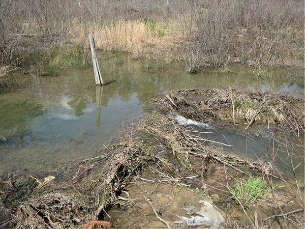
The Beaver Pond Loop’s namesake
The trail eventually leads you to its namesake beaver dam. Beavers build these dams to stem the flow of running water so that they can raise their families. The pond that is formed actually creates a more active ecosystem than before the dam was built, becoming an excellent habitat for many species of wildlife.
Several different types of birds make the pond their home, like wood ducks, dark-eyed juncos, towhees, nuthatches, and a wide variety of woodpeckers and sapsuckers. Catfish have also found a home here along with salamanders, and, of course, an abundance of mammals frequent the pond, including white-tailed deer, foxes, and raccoons. Being in a wetland, you may come across a snake or two like cottonmouth or water moccasin. If you see one, stop, wait a moment, and it should move along. Remember, all wildlife and plants in the park are federally protected, so do not harm them in any way. There is a short boardwalk here that leads up to the pond, with an observation deck and benches that overlook it and the dam.
For the most part the trail follows a dirt footpath. There are a couple of sections that travel over flat rock and the moss trail bed I mentioned earlier. You will cross over four creeks on some nice footbridges. One of the prettiest is at mile 0.4. As always, keep in mind that water flows in the creek and pond are seasonal and could be low or nonexistent during droughts or the heat of summer. The trail sports several benches as well, just in case you want to take a break and enjoy the forest.
Oh, and by the way, we did end up revisiting and hiking down into the canyon on the Eberhart Trail. Yes, it’s still there, and yes, it is still steep.
 Because of Alabama’s warm and wet weather; the number of water features such as rivers, lakes, and the Gulf of Mexico; and the variety of geologic features, the state has remarkable biodiversity. In fact, Alabama has the most species of plants and wildlife of any state east of the Mississippi River and is fifth overall in the most biodiversity.
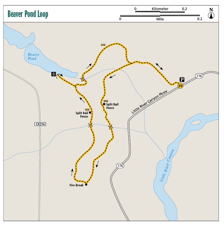
Miles and Directions
|
0.0 |
Start from the parking lot / trailhead off of AL 176 / Little River Canyon Scenic Parkway (it is located just past the second overlook on the parkway, Lynn Overlook, on the right). The parking lot is gravel, with a kiosk and map. There is room for about fifteen cars here. Start by heading southwest on the dirt footpath, with a good mix of hardwoods and pines. The trail is level the entire length. There are no blazes. |
|
0.2 |
Come to a sign that reads “Beaver Pond Overlook 1⁄2 mile” (arrow pointing to right [north]) / “Beaver Pond Loop” (arrow pointing to left [west]). Head to the left and cross a creek over a nice 15- to 20-foot bridge. The forest is thick with pines here. |
|
0.3 |
The canopy opens up a bit. Pass a zigzag split-rail fence on the left and a bench. |
|
0.4 |
Cross a creek over a 20-foot bridge. In the spring the green moss is very pretty here. |
|
0.6 |
A trail comes in from the left (south). This is a fire break; don’t follow it. Continue on the current path to the right (west). |
|
0.7 |
Cross a deep creek over a 10-foot bridge. |
|
0.8 |
The trail travels over a flat rock base for a few yards. Very pretty, thick green moss grows along the edges of the path. Pass another zigzag split-rail fence and a bench. |
|
0.9 |
Come to a Y. A sign points the way to the Beaver Pond. Follow the arrow and head straight (northwest) to the pond. |
|
1.0 |
Arrive at the Beaver Pond. There is an observation deck here and a bench. Turn around and retrace your steps to the last Y. |
|
1.1 |
Back at the last Y, turn left and head east. In less than 0.1 mile, cross a stream over a short bridge. |
|
1.2 |
Pass a bench. |
|
1.3 |
Come to the end of the loop you started at mile 0.2. Turn left (north) and retrace your steps to the trailhead. |
|
1.4 |
Arrive back at the trailhead. |
Hiking Information
Local Information
Fort Payne Chamber of Commerce, 300 Gault Ave. North, Fort Payne, AL 35967; (256) 845-2741; www.fortpaynechamber.com
Local Events/Attractions
Canyon Fest, Little River Canyon Interpretive Center, Fort Payne; (256) 782-5697; www.jsu.edu/epic. Held the first Saturday of November, Canyon Fest celebrates the natural beauty, history, and recreation of the largest canyon east of the Mississippi with a good dose of activities for the kids, food, and music.
Lodging
DeSoto State Park Campground, 7104 DeSoto Pkwy. NE, Fort Payne; (256) 845-5075; www.alapark.com/desotoresort/camping. Improved and primitive campsites.
Restaurants
DeSoto State Park Mountain Inn, 7104 DeSoto Pkwy. NE, Fort Payne; www.alapark.com/desotoresort/%20restaurant. Breakfast is served 7–10 a.m., lunch 11:30 a.m.–2 p.m., dinner 5–8 p.m.
Organizations
Little River Canyon Interpretive Center, 4322 Little River Trail NE, Fort Payne, AL; (256) 845-3548; www.epic.jsu.edu