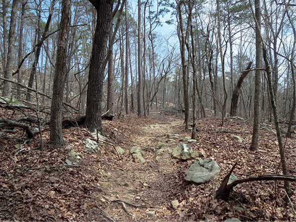
The trees are trying to make a comeback on the Waterfall Loop.
41 Waterfall Trail
The Waterfall Trail at Lake Guntersville State Park is a favorite of many hikers. Its short distance and, of course, its namesake waterfall (which is seasonal) makes it a nice outing for individuals and families, especially in the spring and fall after a good rainfall. Sadly, multiple tornado strikes in 2011 have virtually defoliated the upper portion of the trail, but it is still one worth walking.
Start: Trailhead on Aubrey Carr Scenic Drive
Distance: 1.6-mile lollipop
Hiking time: About 1.5 hours
Difficulty: Easy to moderate with a hill climb
Trail surface: Dirt and rock
Best seasons: Oct–May
Other trail users: None
Canine compatibility: Leashed dogs permitted
Land status: State park
Nearest town: Guntersville
Fees and permits: Day-use fee per car
Schedule: Year-round, sunrise to sunset
Maps: USGS Columbus City, AL; DeLorme: Alabama Atlas & Gazetteer, page 26 A2; free trail maps available at camp store
Trail contact: Lake Guntersville State Park, 7966 AL 227, Guntersville 35976; (256) 571-5455; www.alapark.com/LakeGuntersville
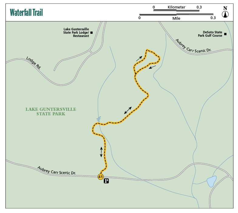
Finding the trailhead: From Guntersville at the intersection of US 431 and AL 227, take AL 227 south 6.6 miles. Turn left onto Aubrey Carr Scenic Drive. Travel 0.2 mile and turn left to stay on Aubrey Carr Scenic Drive. Travel another 0.2 mile. The trailhead will be on the right. The parking lot is gravel, with room for 7 cars. GPS: N34 23.095' / W86 12.374'
The Hike
Just after dawn on April 27, 2011, what the National Weather Service classified as an EF-2 tornado swept across the town of Guntersville. The main area in the path of the storm (that only lasted four minutes) was Lake Guntersville State Park. When the storm had passed, the park had major damage. Cleanup in the area was estimated to be at $2.5 million. In seconds the lodge and campground were severely damaged and over 5,000 trees were snapped like matchsticks; 65 percent of those were near the park’s golf course.
The good news, however, is that the trails were quickly reopened after the storm, due to the hard work of state employees and volunteers. A couple years later I revisited the park to hike the trails for this edition of the book and found it back in operation and almost back to normal. The sad part, however, is that not everything is recovering so quickly, including some of the hiking trails where the recovery will take years to take hold. One of those trails where you can still see the damage is along the Waterfall Trail.
The trail has always been one of my favorites, and it was a sad experience re-hiking it. The northern part of the trail looked more like an area where a nuclear bomb went off than the thick hardwood forest I had remembered. But as I walked the trail, the waterfall was still very pretty tumbling over the rocks after a good rain, and the damage served as a backdrop reminding me of the power of Mother Nature. After walking it the trail was still a favorite and a fun, educational hike for individuals and families.
The trail begins at a trailhead along Aubrey Carr Scenic Highway. There is a small yellow post here that is a fee kiosk. The park requests a small day-use fee per car, with all proceeds going to trail maintenance, so please make sure you pay. The trail is a 3- to 4-foot-wide gravel footpath at the outset, then becomes more of a packed clay and rock bed. It is marked with white paint blazes. Right at the trailhead you will see the orange-blazed Moonshine Trail coming in from the left (west) and an un-blazed connector trail to the right.
The path has an easy to moderate grade as it meanders up the north side of the mountain, heading toward the golf course at the top. The beginning of the hike travels through a mixed forest that includes members of the beech family, like chestnut and upland willow oaks. Squirrels and woodchucks rummage here as well as white-tailed deer, and sometimes ring-necked pheasants may surprise you from the brush.
The trees are trying to make a comeback on the Waterfall Loop.
From early spring through fall, some wildflowers will be seen, including the lavender-leafed liatris, which blooms in early fall. You’ll also find penstemon with leafy clusters of fifty or so lavender flowers. The smooth foxglove grows on the sides of white oak trees, bearing yellow flowers June through October.
The best time to hike this trail is from fall to spring when there has been a good rain. The trail crisscrosses a rocky stream three times, each crossing having a little taller cascade. The tumbling waters are beautiful, and in the fall the yellows and oranges of the unaffected hardwoods make the stream even more lovely.
Following the stream crossing, the canopy opens up due to the number of downed trees. On a summer day this can be one hot climb. Throughout this section you will see the power of Mother Nature. It is an amazing sight and an educational one as well, a good place to discuss weather with your children and what to do when severe weather strikes.
The trail continues up the mountain until it comes to within yards of the golf course. Here the Waterfall Trail ends. The Nature Trail comes in from the left (west) and heads north. The park’s lodge (which has a great restaurant and spectacular views of the lake and surrounding mountains) can be reached by following the Nature Trail. Also here at the end of the Waterfall Trail is the connection with the blue-blazed Cascade Loop. Now, normally I would add this connection to the hike, but when I visited, the trail had virtually vanished. The hike described here uses an un-blazed connector trail to loop around and rejoin the Waterfall Trail for the return to the trailhead. Hopefully by the time you read this, the Cascade Loop will be back and well blazed. It’s well worth the effort to add the additional 0.5 to 0.75 mile to see another waterfall and a view of the lake.
Remember that the stream is seasonal. It could be a torrent of water cascading down one day, a trickle the next.
Miles and Directions
|
0.0 |
Start at trailhead on Aubrey Carr Scenic Drive. To the north you will see the yellow fee kiosk. Just past the kiosk the orange-blazed Moonshine Trail comes in from the left (west) and an un-blazed connector trail from the right. Head north on the yellow-blazed Waterfall Trail (there is also a large vertical sign indicating that you’re on the right trail in a dozen yards). The trail is a 3- to 4-foot-wide hard-packed clay and gravel footpath. There is a little canopy at this point but not for long. The first signs of the 2011 tornado can be seen here, with trees snapped off on either side of the trail. |
|
0.2 |
Stream crossing. You will cross the stream again in less than 0.1 mile. |
|
0.3 |
Another stream crossing. During times of rain a really nice waterfall cascades over the large rocks here. In less than 0.1 mile, pass the orange-blazed Old Still Trail on the right (south). Continue straight on the Waterfall Trail. The canopy really begins to thin out and is mostly nonexistent until you begin the return at the end of the loop. Because the trees are all laid out flat from the storms, you will be able to see the tops of all of the surrounding hills and other trails that you wouldn’t normally see. |
|
0.7 |
Pass the un-blazed connector trail to your right (east). This will be the south end of the loop. |
|
0.8 |
The park’s lodge, water tower, and golf course can be seen to the north. The Waterfall Trail ends here. The red-blazed Nature Trail comes in from the left (northwest) and bends to the north. The blue-blazed Cascade Loop Trail is to your right (southwest). Turn right onto the Cascade Loop. |
|
0.9 |
Come to an un-blazed connector trail. At this point during my visit, the Cascade Loop had vanished (no more blazes or indications of a path). Hopefully when you read this, the trail will be back and you can use it for a longer loop. In the meantime, turn right (south) onto the connector trail. |
|
1.0 |
Come to an intersection. Turn left (south) onto the Waterfall Trail and retrace your steps to the trailhead. |
|
1.6 |
Arrive back at the trailhead. |
Hiking Information
Local Information
Marshall County Convention and Visitors Bureau, PO Box 711, 200 Gunter Ave., Guntersville, AL 35976; (800) 582-6282; www.marshallcountycvb.com
Local Events/Attractions
Eagle Awareness Weekends, 7966 AL 227, Guntersville; (256) 571-5440. American bald eagles have made a huge comeback in Alabama, and each winter hundreds of visitors come to Lake Guntersville State Park to view the birds and attend dozens of presentations on the raptor. There are even special 5 a.m. treks to watch the eagles leave their nests and 4 p.m. return-to-roost watches. The event is held from January through the third weekend of February.
Restaurants
Pine Crest Dining Room, Lake Guntersville State Park, 1155 Lodge Dr., Guntersville; (800) 548-4553. Great menu options, great food, all at reasonable prices.
Hike Tours
Park rangers and volunteers hold regular guided Saturday morning hikes. Contact the park office for schedule.