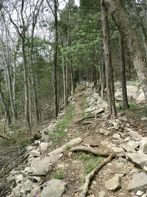
The Waterline Trail portion of this hike is slightly elevated and rocky.
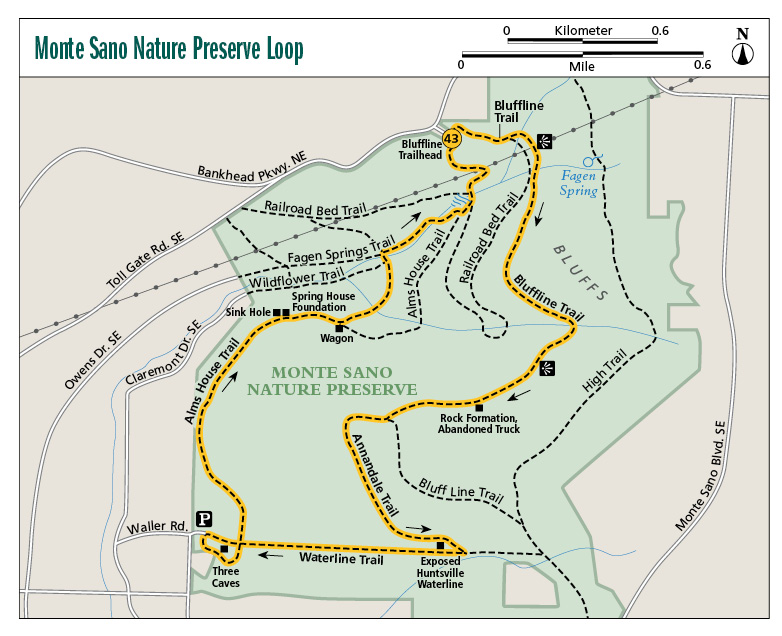
43 Monte Sano Nature Preserve Loop
A beautiful all-encompassing hike on the west side of Monte Sano Mountain, the Monte Sano Nature Preserve Loop takes in a little of everything. Along the route you will walk beside massive rock bluffs, cross many streams, walk through a field of wildflowers, pass a waterfall or two, and have great views of the huge Three Caves Quarry. The trail is moderately rugged, and after hiking the entire length, the last climb can be a challenge.
Start: Hikers’ parking lot off Bankhead Parkway NE
Distance: 4.9-mile loop
Hiking time: 2.5–3 hours
Difficulty: Moderate to difficult due to length and some steep climbs near end of loop
Trail surface: Dirt and rock
Best seasons: Late fall–late spring
Other trail users: None
Canine compatibility: Leashed dogs permitted
Land status: Land trust property
Nearest town: Huntsville
Fees and permits: None; donation requested at trailhead lockbox
Schedule: Year-round, sunrise to sunset
Maps: USGS Huntsville, AL; DeLorme: Alabama Atlas & Gazetteer, page 19 D8; trail maps available online at the Land Trust of North Alabama website
Trail contact: Land Trust of North Alabama, 2707 Artie St. SW, Ste. 6, Huntsville, AL 35805; (256) 534-5263; www.landtrustnal.org
Special considerations: To help protect the trails from erosion, the Land Trust asks that you do not hike the trails after rain. Wait a few days after rain for the trails to dry before heading out. It is OK to hike if the ground is frozen, but when the temperatures go above freezing again, wait a day or two for the trails to dry out.
Finding the trailhead: From Huntsville on I-565 at exit 21, head south on Maysville Road NE 1.4 miles and turn left onto Pratt Avenue NE. Travel 1.4 miles. The parking lot and trailhead will be on your right and well marked. GPS: N34 44.610' / W86 32.640'
The Hike
Through the years the mountain area around Huntsville has seen its share of business and residential development, posing a threat to forests along Round Top and Monte Sano Mountains. For a time Monte Sano State Park was the only oasis of preservation. All that changed when a group of volunteers formed the Huntsville Land Trust (now known as the Land Trust of North Alabama). Their objective: to preserve nature in Madison County. Through contributions and land donations, several preserves were established to not only protect beautiful natural settings, but also provide amazing recreational opportunities for hikers.
The largest and most popular of the trust’s sanctuaries is Monte Sano Nature Preserve. With land purchases and donations plus the land that makes up Monte Sano State Park, most of the forested hillside of Monte Sano Mountain has been protected from further development.
I can’t say enough about the excellent job the Land Trust and its volunteers have done with building and maintaining trails on their properties. Each one highlights a piece of the preserve’s rugged beauty. The trail described here, what I cleverly call the Monte Sano Nature Preserve Loop, traces the west side of Monte Sano Mountain by using several different trails. There are plenty of opportunities for you to create your own loop of exploration, but the one I describe here visits a good many of the preserve’s standout features.
With only a few exceptions, the trails are well blazed with metallic diamond markers labeled with HLT (Huntsville Land Trust) and the trail name. The first section of the route, known as the Bluffline Trail, travels along the base of massive limestone bluffs. The trail crosses several creeks and passes two nice cascades. Remember that many streams are seasonal. The best time to catch a good flow is late fall to late spring.
The Waterline Trail portion of this hike is slightly elevated and rocky.
I have changed things up a bit since the last edition. After the Bluffline Trail we now use the Annandale Trail to go to the Waterline Trail. This is an interesting little trail with some rock features, and it actually leaves the preserve and cuts through the state park for most of its length.
Annandale then meets up with the Waterline Trail at a creek crossing, where there is a nice cascade after good rains. The trail is so-named because sections of a water main that were used during the 1950s for the city of Huntsville run through here. Sections of the pipe are exposed for you to see.
At the intersection of the Waterline and Alms House Trails is the Three Caves Loop. The loop is a 0.2-mile trail around the quarry that gives you excellent views of the caves that were once mined for limestone. There are several steel fences here that you can stand by and look down into the quarry, but this is a dangerous place. Heed the warning signs and keep children, and yourself, away from the edges of the steep and deep cliffs. Also on the loop you will pass a road that leads directly to the caves. Do not go to the caves! Entry is by permission only.
The Alms House Trail levels things out for a bit, though the path is rocky for the most part. On this section you will pass the foundation of an old springhouse. This stone structure was once used as an early form of refrigeration, using the spring that ran beneath it to cool meats and vegetables.
On the final stretch to the parking lot, we use a short stretch of the Wagon Trail to visit a beautiful wide stream and the Fagen Springs Trail to pass an impressive waterfall (again, remember that flows are seasonal). The final stretch uses the Alms House Trail once again, taking you steeply uphill to the trailhead. This last section has few markers, so read the mile-by-mile description below and keep your eyes peeled for the trail bed.
 The city of Huntsville stepped from its cotton-based economy to being a leader in high-tech industry when Dr. Wernher von Braun and his team of rocket scientists came to the city to get the US space program literally off the ground. His successes included the building of the first American rocket to send a satellite in space (the Jupiter C), the Redstone rocket that sent the nation’s first man into space, and, of course, the Saturn V that sent men to the moon. Needless to say, Huntsville is known as the Rocket City.
Miles and Directions
|
0.0 |
Start from the parking lot on Pratt Avenue NE. A sign here indicates where to enter the trail to the northeast. In 100 feet come to a sign that shows the direction of the Bluffline and Old Railroad Bed Trails (the signs are carved wood with red lettering). Turn to the right (southeast). The trail is not blazed at this point, but it is a 2- to 3-foot-wide dirt and rock footpath. The trail has a dense canopy with many pines. In less than 0.1 mile, pass a short side trail to an education pavilion on the right (south). |
|
0.1 |
Diamond-shaped “HLT Bluffline” markers begin, tacked to trees. The Old Railroad Bed Trail comes in from the right (south). Continue straight (east) on the Bluffline Trail. |
|
0.2 |
Cross a stream, with nice cascade when it is flowing. The trail widens to a 4-foot-wide clay and dirt path. |
|
0.3 |
Cross a power line. There are views of the surrounding mountains and valley (the giant Saturn V that stands at the Space and Rocket Center can be seen in the distance). In less than 0.1 mile, cross a stream (this one is wide and fast after a good rain). There is a bench here. The trail’s namesake bluffs begin on the left. |
|
0.4 |
Cross a small creek. |
|
0.5 |
Cross an intermittent stream. |
|
0.7 |
The trail bed is a mix of rock and dirt and can be deep in mud after rain (see “special considerations”). There are cedars and pines through here with a swift-flowing stream downhill to the right. |
|
0.8 |
Cross a small creek, followed in less than 0.1 mile by a wider rocky stream crossing. |
|
1.0 |
Good view of the bluff on the left. |
|
1.1 |
Cross a creek. |
|
1.2 |
A discarded rusty truck is downhill on the right. The bluff continues on the left (southeast). There are some interesting rock formations here, including an outcropping that has been etched by the elements, making it look like the rocks have been stacked. |
|
1.4 |
The Wagon Trail comes in from the right (north). Continue straight on the Bluffline Trail (there is a directional sign here). In less than 0.1 mile, come to a Y. The Bluffline Trail heads uphill to the left (southeast). Turn right (southwest) onto the Annandale Trail; the trail is now blazed with diamond-shaped “MSSP Annandale Trail” markers (MSSP stands for Monte Sano State Park). The trail is mostly dirt and can be very boggy after rain. It is enclosed and has more hardwoods here. |
|
1.6 |
Cross a stream. |
|
1.9 |
The trail has a deep gully in it that can fill knee-deep with water after a good rain. In a few hundred yards, pass a whitish gray bluff and outcroppings on the left, with plenty of wildflowers growing from the tops in the spring. The trail is back in the preserve and out of the state park. |
|
2.0 |
Come to a bench and a set of log stairs. At the bottom turn right (southwest) onto the Waterline Trail. The trail is elevated, almost like a railroad bed. The trail bed is narrow (11⁄2 feet) and mostly rock. There are several areas along the trail that have steep drop-offs to the left (south). |
|
2.1 |
The old Huntsville water line can be seen popping out of the ground on the left. |
|
2.3 |
The Young Kennedy Trail comes in from the right (north); continue straight on the Waterline Trail. The trail becomes less rocky, mostly dirt bed. |
|
2.6 |
Pass a sign warning you that you are approaching Three Caves, with dangerous bluffs, and to keep your children away from the edge. In a few yards come to a Y at a sign pointing the way to the Three Caves Loop, Waterline Trail, and Alms House Trail. Continue straight (west) on the Three Caves Loop. |
|
2.8 |
Come to a gravel parking lot. Walk along the east side of the lot to a kiosk. Next to the kiosk is a set of railroad tie stairs. Head up these stairs to continue the loop to the west. In a few yards cross a gravel road. Do not turn down the road and go to the caves! Special permission is required. Continue straight across the road to the south and continue following the loop. |
|
3.0 |
The Cave Loop ends back at the Y at mile 2.6. Continue straight to the north on the Alms House Trail. The trail is very rocky, with several intermittent stream crossings. |
|
3.2 |
The trail follows a flat rock bed, then climbs through some rocks. |
|
3.4 |
The Alms House–Wagon Trail Connector comes in from the right (east). Continue straight (north) on the Alms House Trail. |
|
3.6 |
Cross a creek. |
|
3.7 |
Pass the Sink Hole Trail on the left (north). There is a small sinkhole between the two trails. Continue straight (east) on the Alms House Trail. In a few yards pass the springhouse foundation on the left (south). |
|
3.9 |
Come to the intersection of the Wagon and Alms House Trails. Turn left (northeast) onto the Wagon Trail. |
|
4.0 |
Cross a wide stream. |
|
4.1 |
Pass the Wildflower Trail on the right (east). Continue straight on the Wagon Trail. In less than 0.1 mile, cross a wide rocky stream. Just after crossing, start climbing uphill on the rocky slope and in a few yards turn right (east) onto the Fagen Springs Trail. The path is not well defined here, so keep your eyes peeled. |
|
4.2 |
Cross Fagen Springs over a bridge. Nice waterfall to the right (south). |
|
4.3 |
Cross the spring again over a 20-foot bridge. Come to an intersection. Turn left (east) onto the Fagen Springs / Wildflower Trail. (A sign here points the way to Toll Gate Road, Railroad Bed, and Owens Drive.) |
|
4.5 |
Pass a very rocky area of the stream. There is a nice waterfall here. The trail markers are virtually gone through this section. Keep your head up and watch for a green sign with a yellow arrow pointing the way on a tree. In a few yards come to a T intersection with the Alms House Trail. Turn left (northeast) onto the Alms House Trail. In less than 0.1 mile, come to a T intersection with the Railroad Bed Trail. Turn left (northwest), heading toward the falls. (FYI: A sign here says to take a right, but it appears to be backwards. Take the left. After the sign, cross the stream again.) |
|
4.7 |
Cross a power line. There is a beautiful, fragrant wildflower glade here in the spring. Start a long, steady, rocky uphill climb. |
|
4.8 |
A trail comes in on the right (northeast). It looks like the trail should go straight, but it doesn’t. It dead-ends. Turn right onto the unmarked trail, which is still the Alms House Trail. (There are some markers in a few yards, but they are for those heading in the opposite direction.) Very steep climb here over rocks. |
|
4.9 |
Arrive back at the trailhead. |
Hiking Information
Local Information
Huntsville / Madison County Convention and Visitors Bureau, 500 Church St., Ste. 1, Huntsville, AL 35801; (256) 551-2230; www.huntsville.org
Local Events/Attractions
Burritt on the Mountain, 3101 Burritt Dr., Huntsville; (256) 536-2882; www.burrittonthemountain.com. Take a trip back in time to the 1800s in the home and grounds of the eccentric Dr. Burritt.
Lodging
Monte Sano State Park Campground, 5105 Nolen Ave., Huntsville; (256) 534-6589; www.alapark.com/montesano. Improved and primitive campsites.
Restaurants
Blue Plate Cafe, 3210 Governors Dr., Huntsville; (256) 533-8808; www.blueplatecafe.com. Classic Southern food like Mom (or Grandma) used to make.

This waterfall on the Fagen Springs Trail is something to see in late winter and early spring when it runs full.