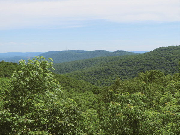
A view from the trail into McKay Hollow
45 North Plateau Loop
Another easy hike, this one travels around the northern plateau of Monte Sano Mountain. Once again, the trails are wide, well maintained, and cross several nice seasonal creeks. The highlight of this trip includes a short side trail to a beautiful 70-foot waterfall at the end of the picnic area. There are several nice overlooks and a chance to see the handiwork of the Civilian Conservation Corps from 1935.
Start: Kiosk on the south side of the hikers’ parking lot
Distance: 1.9-mile loop
Hiking time: About 1 hour
Difficulty: Easy on a level path around the rim of Monte Sano Mountain
Trail surface: Dirt
Best seasons: Fall–spring
Other trail users: Cyclists
Canine compatibility: Leashed dogs permitted
Land status: State park
Nearest town: Huntsville
Fees and permits: Day-use fee (under 6 free)
Schedule: Year-round, 7 a.m.–sunset
Maps: USGS Huntsville, AL; DeLorme: Alabama Atlas & Gazetteer, page 19 D8; free trail maps available at park office.
Trail contact: Monte Sano State Park, 5105 Nolen Ave., Huntsville, AL 35801; (256) 534-3757; www.alapark.com/montesano
Finding the trailhead: From Huntsville on I-565 take exit 21, Maysville Road NE. Head south on Maysville Road NE 1.4 miles and turn left onto Pratt Avenue NE. Travel 2.7 miles and turn right onto Fearn Street NE. Travel 0.7 mile and turn left onto Nolen Avenue SE. Follow Nolen Avenue SE 0.7 mile to the entrance gate, where you’ll pay your day-use fee. Continue straight on Nolen Avenue SE 0.4 mile. Come to a Y in the road and take the right fork. The hikers’ parking lot will be immediately on your right. GPS: N34 44.637' / W86 30.676'
The Hike
While the South Plateau Loop focuses more on the geology of the mountains, with wonderful views from high bluffs, the North Plateau Loop shows more of the history of Monte Sano State Park but still provides nice views of the surrounding valleys and mountains and a waterfall.
Monte sano is a Latin term that means “mountain of health.” In the early 1800s, with outbreaks of yellow fever, cholera, and malaria ever increasing, this mountain became a refuge for ailing patients because of the crisp, cool mountain air and clear mountain streams.
In 1827 Dr. Thomas Fearn established a colony here on Monte Sano for the victims of these epidemics. The lavish facility flourished until the advent of the Civil War, when Union soldiers made their way south and laid the complex in ruin.
Following the Civil War, the area was rebuilt. The Monte Sano Hotel was constructed and the region flourished once again with tourists to the mountain until the Great Depression arrived in the 1930s. President Franklin Roosevelt’s Civilian Conservation Corps (CCC) arrived in 1935, and the rebuilding process began. Cabins, picnic areas, horse barns, trails, roadways, and a public lodge were all completed by 1938, and Monte Sano State Park was born. Because of all this construction, this section of the trail has been described as looking more like a city park than a state park, but how many city parks have waterfalls running through them?
A view from the trail into McKay Hollow
The trail begins at the hikers’ parking lot and loops the north plateau to the west. As it moves along a wonderful bluff, it passes a small creek and a nice waterfall. Traveling through a picnic area, evidence of the CCC influence is seen with the ruins of the Monte Sano Tavern. The tavern was built in 1937 but was destroyed by fire in 1947. This is one of the largest remains of CCC buildings in the state and is an excellent example of the stonemasonry of the corps.
Continuing on to the west, an amphitheater, also constructed by the CCC, will be seen. It is used for a variety of entertainment and educational programs. Just past the amphitheater, a beautiful 70-foot waterfall tumbles down the rocks and is a haven for artists painting and drawing any time of the year. As the trail loops around the plateau, there are nice views of the rocky outcroppings known as The Sinks (where the Stone Cuts Trail travels) and Mills Hollow.
Finally, more recent Monte Sano history will be seen at the Von Braun Observatory. When Dr. Wernher von Braun came to Huntsville to head up the American space program and its new facility in Huntsville, he and his colleagues helped guide the building of this planetarium and observatory. Opened in 1956, the facility is operated by the Von Braun Astronomical Society. Von Braun and astronaut Alan Sheppard used to visit the facility to talk about the Apollo program. The first and second Saturday of each month, the society holds a meeting that the public is invited to attend. A view of the night sky, a lecture by prominent astronomers and NASA scientists, and, weather permitting, views through the telescopes are in store.
The hike is interesting and makes a good warm-up for the more difficult Stone Cuts Trail.
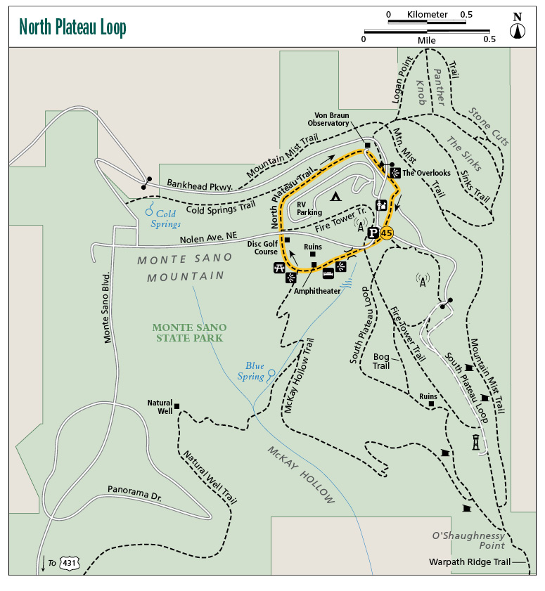
Miles and Directions
|
0.0 |
Start at the hikers' parking lot to the south. Immediately after passing the kiosk, turn right onto the blue-blazed North Plateau Loop Trail. In 400 feet pass hole #10 of the disc golf course on the right. |
|
0.1 |
Cross the red-blazed Fire Tower Trail. |
|
0.2 |
Cross a runoff with a small cascade on a 30-foot footbridge. |
|
0.3 |
Walk behind the lodge to the first overlook. |
|
0.4 |
Pass the amphitheater on the right. In 50 feet walk through a picnic area. In less than 0.1 mile, cross a small creek. |
|
0.5 |
Pass another overlook on the left. In 120 feet pass a CCC picnic pavilion on the left. The McKay Hollow Trail merges here from the right side of the pavilion. Continue to the right (northeast) on the blue trail. (Option: Head down the McKay Hollow Trail for a few short yards to view the waterfall. Be careful, it’s steep and slippery.) In just over 100 feet, the trail leaves the picnic area and heads back into the woods. |
|
0.7 |
Cross the disc golf course. In 50 feet cross the main park road at the entrance station. |
|
0.8 |
Pass the red Fire Tower Trail on the right. You will also be passing the primitive campground on the right. |
|
0.9 |
The trail meanders beneath the campground. Drop off into a ravine on the left. There is a nice little view here in winter. |
|
1.0 |
Pass the Cold Springs Trail on the left. |
|
1.1 |
The closest approach to the campground is on the right. |
|
1.3 |
Pass Von Braun Observatory on the right. |
|
1.5 |
Arrive at what looks like a T intersection, but the left turn is merely a game trail. Turn right (southeast) and continue on the North Plateau Loop. In 60 feet cross a road to reach the overlook parking lot and arrive at the overlook. In 150 feet the trail heads back into the woods on the south side of the parking lot. |
|
1.7 |
Cross a paved road to the south. |
|
1.8 |
Pass a picnic pavilion on the right and come to a trailer that at the time of this writing was being used as a temporary office to register campers. Walk around the left side of the trailer and pick up the blue blazes on the other side to the south. |
|
1.9 |
Cross another paved road and arrive back at the hikers’ parking lot. |
Hiking Information
Local Information
Huntsville / Madison County Convention and Visitors Bureau, 500 Church St., Ste. 1, Huntsville, AL 35801; (256) 551-2230; www.huntsville.org
Local Events/Attractions
US Space and Rocket Center, One Tranquility Base, Huntsville; (800) 637-7223; www.rocketcenter.com. Crammed with over 1500 artifacts documenting America’s space program from its earliest days to the present, with lots of interactive fun for kids.
Lodging
Monte Sano State Park Campground, 5105 Nolen Ave., Huntsville; (256) 534-6589; www.alapark.com/montesano. Improved and primitive campsites.
Restaurants
Another Broken Egg Cafe, 2722D Carl T. Jones Dr., Huntsville; (256) 883-2915; www.anotherbrokenegg.com
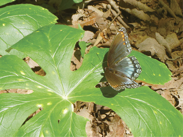
A butterfly going about his business on the North Plateau Loop