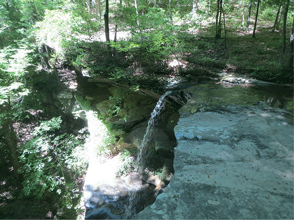
One of many falls and rock shelters at Cane Creek
49 Cane Creek Canyon Nature Preserve
One of the most fascinating hikes in the state, Cane Creek Canyon Nature Preserve combines some of the most remarkable canyon scenery you’ll find anywhere. Spectacular ancient rock shelters, waterfalls, and a rainbow of rare wildflowers await you on this hike.
Start: Parking lot next to Jim and Faye Lacefield’s house
Distance: 4.0-mile multiloop
Hiking time: About 2 hours
Difficulty: Moderate with some steep inclines
Trail surface: Combination dirt, gravel, and rock paths
Best seasons: Fall–early summer
Other trail users: None
Canine compatibility: Leashed dogs permitted
Land status: Privately owned
Nearest town: Tuscumbia
Fees and permits: None
Schedule: Year-round, sunrise to sunset
Maps: USGS Frankfurt, Pride, AL; DeLorme: Alabama Atlas & Gazetteer, pages 16 F5 and 17 F6
Trail contacts: Jim and Faye Lacefield, 251 Loop Rd., Tuscumbia, AL 35674; (256) 381-6301; www.facebook.com/pages/Friends-of-Cane-Creek-Canyon-Nature-Preserve/126802417335447
Finding the trailhead: From Tuscumbia at the intersection of US 72 and Veterans Boulevard, take US 72 west 0.7 mile and turn left onto CR 65 / Frankfort Road. Travel 7.6 miles and turn right onto Loop Road. In 0.2 mile as Loop Road bends to the right, continue straight on a gravel road (a sign points the direction to the preserve). Travel 0.3 mile, passing an old poultry farm on the left and through a gate indicating the entrance to the preserve, until you come to a Spanish-influenced house. This is the Lacefields’ home. You will see signs plainly indicating where to park. GPS: N34 37.332' / W87 47.668'
The Hike
In other hikes in this book, I’ve probably used the words “spectacular” and “beautiful” ad nauseam. But each hike has held something a little more “spectacular” than the last, making each special in its own right. So here we are, nearing the end of our journeys, and lo and behold . . .
In 1976 Jim and Faye Lacefield purchased a modest amount of property at what is now the south end of this preserve. They knew what the property to the north held and knew it had to be protected. The owner of the northern property, after opening it to logging, sold his 400 acres to the Lacefields in 2000, and Jim and Faye went to work.
Using abandoned logging roads and building their own footpaths to hard-to-access areas, the Lacefields have created a fascinating look at not only wildflowers and waterfalls, but also the distant past. Etched on the walls of this canyon is the geologic record of an ancient time dating back to when all of the continents were joined as one and known as Pangaea. This region was part of an ancient barrier island; evidence of its sand dunes is etched in the towering sandstone cliffs.
The actions of the creek and the environment over the ages molded this canyon, creating astounding rock shelters, many of which were used by Native Americans for refuge during the Mississippian period. Artifacts can still be found, but remember it is a federal crime to take any that you might find!
Almost immediately after heading out from the trailhead, you will come to the first of many rock shelters. This one features a tiered waterfall cascading down the overhanging rocks. But wait, there’s more! Even more breathtaking rock shelters are on the way, including Tree Fern and wonderful views high above the canyon from The Point. In the distance you will be able to see mountains 6 miles away, with no trace of civilization between you and those peaks.
One of many falls and rock shelters at Cane Creek
Another highlight is the Boulder Garden. Atop giant boulders grow grass and a multitude of wildflowers. Visitors flock to the preserve between mid-March and mid-May to see yellow lady’s slippers, trout lily, and mountain laurel, to name only a few. Many rare species can be found here as well, such as the giant columbo.
And, of course, along most of the trip you will encounter Cane Creek itself, a beautiful blue-green creek that helps shape the preserve. Along its banks is a picnic area known as Linden Meadows, which makes a nice stop and a place where you can see periwinkles (small creek snails) by the hundreds along the creek banks, a sign of the purity of the water. But even so, the Lacefields make sure there is a jug of drinking water here as well as several other locations around the preserve in case you need to refill.
The trail described here is only a short subset of the myriad trails that wind their way through the preserve. Once you get your feet wet and experience the canyon, I’m sure you will be back again and again to travel deeper into the canyon to experience features like Karen and Johnson Falls, the Yellow Wood Falls Rock Shelter, and the impressive rock overhangs of Devil’s Hollow.
When you arrive at the preserve, you will park next to the Lacefields’ home. Please stop by their house and let them know of your hiking plans. Whether or not they are in, be sure to sign the register at the kiosk next to the parking lot. Jim and Faye are fantastic hosts. They’ll give you an overview of what you’ll see, and often if they have time will join you, taking you on a personal and unforgettable tour of the preserve.
There are five backcountry primitive campsites available on a first-come, first-served basis at the preserve. You must reserve a campsite at least two weeks in advance. Visit the preserve’s Facebook page to download a registration form.
 Alabama’s state rock is marble. The largest concentration of the rock is a narrow belt that runs from the Coosa River to near Talladega. The marble is known around the world for its crystalline texture and brilliant whiteness. Since 1900, 30 million tons of marble have been quarried.
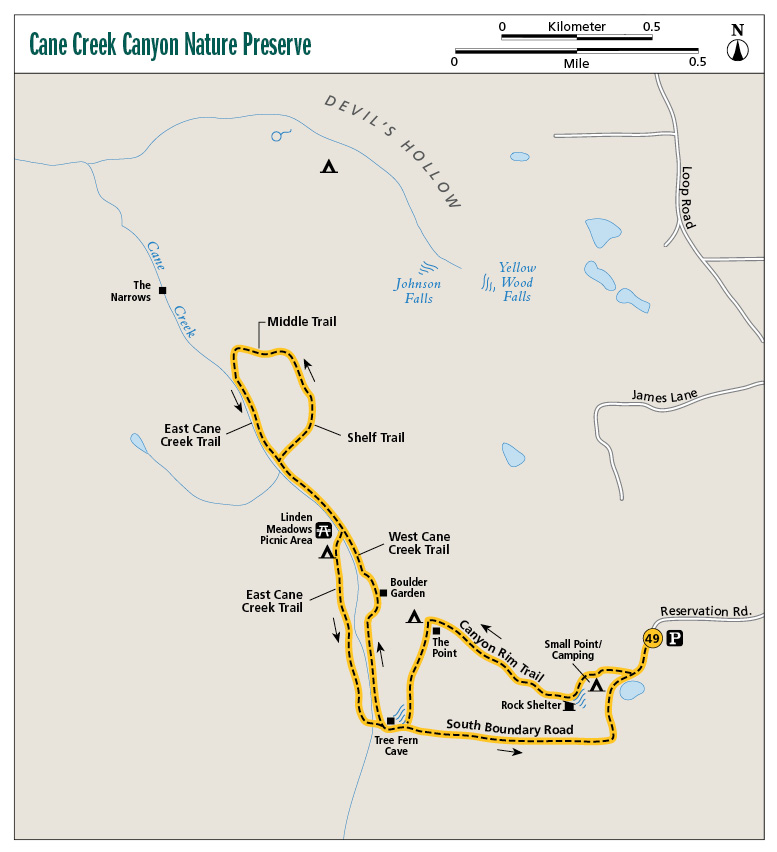
Miles and Directions
|
0.0 |
Start at the parking lot at the Lacefields’ house. Take the dirt road 250 feet. A trail Ys to the right (west). Turn right here onto that trail. In a few feet you will pass a portable toilet on the left. |
|
0.2 |
Arrive at Small Point. Pass three portable toilets and a campsite. A sign here points the direction of the Waterfall Trail. A series of stairs leads down the hill a short distance. |
|
0.3 |
Come to a waterfall and rock shelter. Be very careful along the rim of the gorge! Follow the advice of the sign here that reads “Best View of Falls is on Rock Ledge Across Footbridge.” Cross the narrow footbridge to the south and come to a Y. A sign here points to the left fork and the way to The Point and the Canyon Rim Trail. Take the left fork uphill (west). (Option: After crossing there is a short side trail that leads to the base of the falls). |
|
0.4 |
Pass a bench on the right (good view of falls in late fall–winter). In 300 feet come to a T intersection at a wide dirt road. Take the right fork (a sign here reads “Canyon Rim Trail” and points the direction). |
|
0.7 |
Come to a portable toilet and campsite. Turn to the right (northwest). |
|
0.8 |
Arrive at The Point with its panoramic view. There are benches here and in late spring walls of mountain laurel. To the left (west) is a Y. The right fork is the Steep Trail. Take the left fork to the south on the Canyon Rim Trail. The trail turns into a narrow dirt and rock path, with nice views of valley below to your right. |
|
0.9 |
Pass an overlook from an outcropping hanging out over the canyon. Be careful if you walk out! In less than 0.1 mile, pass another overlook. |
|
1.1 |
Come to a T intersection. Turn right (southeast) onto the wide path, which is a dirt road covered with large gravel to protect it from washout. In 150 feet come to a Y. The left fork takes you back to the house. Take the right fork (southwest). |
|
1.2 |
Pass an old dirt road on the left. In a few feet you will pass a bench and pass through a metal gate. This is part of the South Boundary Road. In 100 feet arrive at the Tree Fern Cave Rock Shelter on the right. In 150 feet come to another Y. Take the right fork. A sign points the way to the main Cane Creek Trail. |
|
1.3 |
Pass a bench and get your first look at Cane Creek. |
|
1.4 |
Come to a Y. The West Cane Creek Trail is down the left fork to the west. Take the right fork. You are now on the East Cane Creek Trail. In 200 feet pass Big Azalea Footbridge on the left. |
|
1.5 |
A short, 30-foot trail to the left leads to the cascades of Cane Creek. |
|
1.6 |
A small trail leads off to the right (east). A sign indicates that this is the Boulder Garden. Turn right here and loop around the two big boulders and wildflowers until you come to a short side trail to the right (west) back to the East Cane Creek Trail. |
|
1.7 |
Back on the East Cane Creek Trail, turn right onto the trail. In 250 feet pass a footbridge and Linden Garden Meadows on the left (west); continue straight to the northeast. There is a stand of bamboo growing here. |
|
1.8 |
Come to a Y. To the left is the East Cane Creek Trail, to the right Waterfall Creek Bridge. Take the right fork to the northeast. You are on the south end of the Shelf Trail. Pass an informational sign: “Waterfall Creek Bridge 30 Yards, the Gap 6⁄10 of a Mile.” In 30 yards cross the footbridge over a nice rocky stream. |
|
2.2 |
The Shelf Trail continues straight to the north. Turn left (west) onto the Middle Trail. |
|
2.3 |
Turn left (southeast) onto the East Cane Creek Trail. |
|
2.4 |
Pass Quarry Bridge over Cane Creek on the right. |
|
2.5 |
Pass Middle Bridge on the right. |
|
2.6 |
Cross a creek over the Lower Waterfall Creek Footbridge. |
|
2.7 |
Return to the Y at mile 1.8. Continue straight to the southwest. In a few yards turn right and cross Cane Creek over a stone and cement footbridge. Look for periwinkles in the stream. After crossing, you are at the Linden Meadows Picnic Area. There is a picnic table, shelter, and water in a jug here. Turn left (southwest) onto the West Cane Creek Trail. The trail is more enclosed and is a narrower dirt road on this side of the creek. |
|
3.1 |
Cross Cane Creek again to the north over a footbridge. In just over 100 feet, come to a Y. The left fork takes you to the East Cane Creek Trail. Take the right fork onto the Southern Boundary Road. |
|
3.4 |
Back at the intersection of the Boundary Road and Canyon Rim Trail, continue straight on the South Boundary Road. In 300 feet pass a wildflower patch to the right. |
|
3.6 |
Pass a trail that leads back to the point on the left; continue straight to the east. |
|
3.7 |
Arrive at a Y. The left fork is a “shortcut” back to the parking lot. It is rather steep. Take the right fork across a short footbridge over a creek. |
|
3.8 |
Pass through a gate; a large wildflower field is to the right. |
|
3.9 |
Pass a pretty little pond on the right. In less than 0.1 mile, arrive back at the first Y at the beginning of the hike. Continue straight toward the parking lot. |
|
4.0 |
Arrive back at the parking lot / trailhead. |
Hiking Information
Local Information
Alabama Mountain Lakes Tourist Association, 402 Sherman St., Decatur, AL 35602; (800) 648-5381; www.northalabama.org
Local Events/Attractions
Fame Recording Studio, 603 E. Avalon Ave., Muscle Shoals; (256) 381-0801; www.fame2.com. Take a tour and see artifacts from the studio that is credited with starting the Muscle Shoals Sound. Fame sold over 300 million records worldwide for stars such as Arthur Alexander, the Tams, and Etta James, and still records artists today.
Restaurants
Dale’s, 1001 Mitchell Blvd., Florence; (256) 766-4961. The origin of the famous Dale’s marinade, serving up delicious steaks and seafood.