The Stone Cuts Trail leads you straight into the limestone “cuts.”
North Region Honorable Mentions
Alabama’s North Region gives you diverse hiking adventures, from panoramic views to breathtaking waterfalls at the geologic fall line. The following trails didn’t make the top of our list, but while in the area, you may want to check them out. These hikes still provide interesting scenery and challenges. Let us know what you think about the selection. Maybe one should be upgraded to the A list, or maybe you know of a hidden gem that would make a good honorable mention.
K Eberhart Trail
Here’s a fine, but difficult, 1.8-mile out-and-back hike to the bottom of the deepest canyon east of the Mississippi, Little River Canyon. This one isn’t for anyone that’s out of shape. It’s a very steep climb down to the rocky banks of the Little River, which cut the sandstone rocks eons ago to create the canyon.
The trail is wide, sometimes 10 to 15 feet in places. About halfway down the canyon wall there is a bench and right behind it a small bluff where you will get a bird’s-eye view of the canyon. (Be careful! These are high and dangerous bluffs.) The canyon walls continue to rise above you until you reach the bottom and the boiling blue-green waters of the river. When you reach the river, take the time to explore, especially a little to the north for a view of Grace’s High Falls, a pencil thin waterfall. (Keep in mind the falls are seasonal.)
Just remember that it’s a long, steep trip back up the canyon wall. Leave yourself plenty of time for the walk out. For more information visit Little River National Preserve online at www.nps.gov/liri/ or call (256) 845-9605. DeLorme: Alabama Atlas & Gazetteer: Page 27 A7.
L Point Rock Trail
Situated within a deep canyon near Lake Guntersville is Buck’s Pocket State Park and the Point Rock Trail. This trail is a steep 2.2-mile out-and-back and rated difficult.
It begins at the park office and heads into the woods at the bottom of a ravine, where it climbs over huge boulders. Just before the trail turns to make the final push to the top of the mountain, a 70-foot-long cascade pops out of the boulders and then drops back into an underground channel known as the Big Sink. This is a seasonal stream, so the best time to view it would be late fall through early spring.
The trail makes its way to the top of Point Rock, a 285-foot-tall sandstone bluff that reaches an elevation of just over 900 feet. An outcropping popular with rock climbers drops off steeply here. The trail makes its way to the very edge of Point Rock, offering panoramic views of the canyon and its sandstone walls. Contact Buck’s Pocket State Park by phone at (256) 659-2000 or visit online www.alapark.com/buckspocket/. DeLorme: Alabama Atlas & Gazetteer: Page 20 H3.
M Russell Cave National Monument
Situated near the borders of Alabama, Tennessee, and Georgia, Russell Cave National Monument has been operated by the National Park Service since 1962. The cave and surrounding landscape are said to hold the oldest and most complete archeological records of human existence in the eastern United States.
The Russell Cave Trail includes a 2-foot-wide asphalt path up the side of Montague Mountain to an elevation of about 1,300 feet. The steep trail weaves through stands of chinquapin, hickory, and chestnut. Deep-green moss clings to rocks along the trail. Wildflowers such as bluets and white rue anemones line the path. White-tailed deer are often seen darting in and out of the brush. The path becomes a boardwalk before arriving at the park’s centerpiece—Russell Cave itself, a large limestone cave that has sheltered humans for more than 9,000 years.
The park hosts many events centered on the long, rich history of the cave throughout the year. Find out more by contacting Russell Cave National Monument at (256) 495-2672 or online at www.nps.gov/ruca. DeLorme: Alabama Atlas & Gazetteer: Page 20 A5.
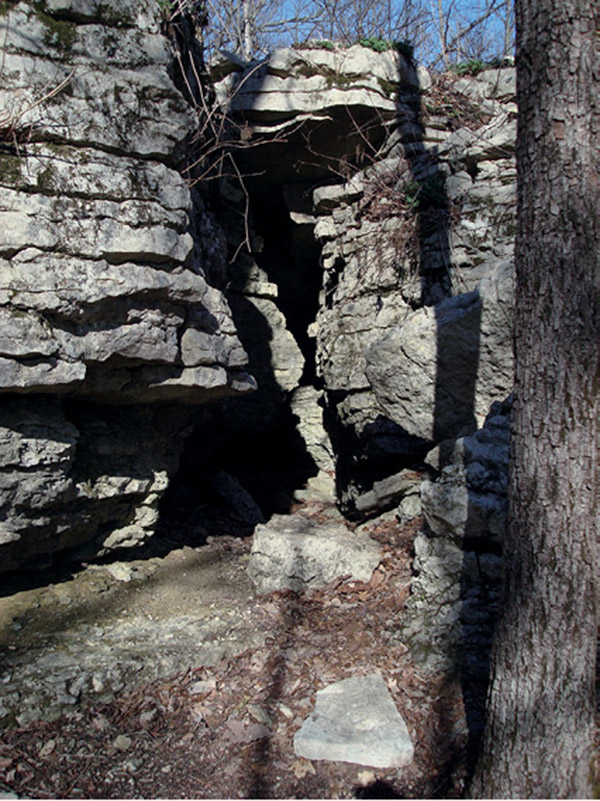
N Stone Cuts Trail
The Stone Cuts Trail is a moderately difficult 3-mile lollipop loop at Monte Sano State Park in Huntsville. The draw to this trail is the deep erosional clefts that have been carved in limestone outcroppings, which the trail runs right through. The “cuts” in the rock have high walls, narrow corridors, and at least one cave chamber to walk through. Kids love climbing around in here, rock climbers love the high cliff walls, and small cave-like spaces in the rocks attract spelunkers. Find out more by visiting www.alapark.com/MonteSano/ or call (256) 534-3757. DeLorme: Alabama Atlas & Gazetteer: Page 19 D8.
The Stone Cuts Trail leads you straight into the limestone “cuts.”