ON WEDNESDAY, MARCH 26, 1980—SIX DAYS AFTER THE FIRST earthquake rocked Mount St. Helens—three dozen or so people squeezed into the first-floor conference room of the US Forest Service Building in Vancouver, Washington, a midsize suburb on the north bank of the Columbia River opposite Portland, Oregon. At nine a.m., Bob Tokarczyk, supervisor of the Gifford Pinchot National Forest, called the meeting to order. Law enforcement officials from all three of the counties adjoining the mountain were there. The state had sent representatives from its Department of Emergency Services, which at that point mostly handled civil defense in Washington, and from its Department of Natural Resources, which was responsible for about 10,000 acres of state-owned forest to the west of Mount St. Helens. As by far the largest landowner and employer in the area, Weyerhaeuser of course had a representative at the meeting. County commissioners, state patrolmen, fire district personnel, reservoir operators, and state geologists sat at the table. And around the edges of the room were an assortment of television, radio, and newspaper reporters, all eager to tell the story of Mount St. Helens’s awakening.
A few minutes after the meeting began, Tokarczyk introduced Donal Mullineaux, who had flown to Portland the night before. Mullineaux, fifty-five, balding, with dark-rimmed glasses and a scientist’s wardrobe, was a geologist with the US Geological Survey who worked out of the survey’s office in the Denver area. But even though he worked in Colorado, no one knew more about the geology of Mount St. Helens than he did. For two decades, he and his colleague Dwight Crandell—whom a college geology professor once called Rocky, after which the name stuck—had been spending their summers driving and walking around Mount St. Helens, looking up at the mountain, and wondering what might happen. Like the four other volcanoes in Washington State, Mount St. Helens is a stratovolcano, meaning that it’s made up of layers of ash, rock, lava, and mud—a sort of geological parfait. By digging into ridgetops, hillsides, and river valleys around the volcano, Mullineaux and Crandell had learned more about Mount St. Helens than was known about any other volcano in the Cascade Mountains. Building on earlier work, they confirmed that the volcano was relatively young, having formed about 40,000 years ago. They divided its frequent eruptions into four periods, with the latest starting about 4,000 years ago. The cone of the volcano, they showed, was less than 2,500 years old—younger than the Acropolis in Athens. That’s why the mountain was so symmetrical and smooth—glaciers had not yet had time to scour out deep valleys on the mountain’s sides. They discovered that Spirit Lake, just to the north of the volcano, was formed when a landslide from the mountain blocked the north fork of the Toutle River several thousand years ago. They found that the town of Toutle was built on an ancient mudflow generated by the volcano.
They also learned that, over the last four millennia, Mount St. Helens had been the most active and explosive volcano in the United States. Two years before that meeting in Vancouver, Mullineaux and Crandell had published a report entitled Potential Hazards from Future Eruptions of Mount St. Helens Volcano, Washington: An Assessment of Expectable Kinds of Future Eruptions and Their Possible Effects on Human Life and Property. In that report, they described the evidence they had found documenting the volcano’s violent past. They had uncovered a foot-thick layer of white pumice blown from the volcano to a ridge six miles to the east in about the year 1500. Five hundred years before that, a “strong laterally directed explosion” threw what are known as lava bombs more than three miles from the volcano. In their travels over the countryside, Mullineaux and Crandell found thick layers of ash from Mount St. Helens hundreds of miles away.
Over the past millennium, the mountain had erupted about once every hundred years, Mullineaux and Crandell wrote. The last eruption was in 1857—a pioneer newspaper reported that year that the volcano “has for the last few days been emitting huge volumes of dense smoke and fire, presenting a grand and sublime spectacle,” and a Canadian artist named Paul Kane, who visited the area a few years earlier, painted the volcano with a red-hot eruption spewing from its northern flank. At times over the past four thousand years the volcano had gone dormant for a few centuries, but it did not appear to be in a dormant period anymore, Mullineaux and Crandell wrote. “In the future,” they concluded, “Mount St. Helens probably will erupt violently and intermittently just as it has in the recent geologic past, and these future eruptions will affect human life and health, property, agriculture, and general economic welfare over a broad area.” In fact, an eruption could be expected “perhaps even before the end of this century.”
At the meeting in Vancouver, Mullineaux recounted this dire history for the assembled officials. He observed that a landslide could cascade down the southwest side of the mountain into Swift Reservoir and overtop the Swift Dam, triggering a flood that could devastate downstream communities. He pointed out that mudflows could travel down river valleys faster than a man could run. Most alarming of all, he mentioned the possibility of pyroclastic flows. Being in a pyroclastic flow is sort of like being in the most powerful hurricane on earth but with most of the atmosphere replaced by red-hot pulverized rock. Such a flow can travel at speeds of hundreds of miles an hour up and over ridges, down valleys, and around obstacles. People die by suffocating on the stone dust that fills their lungs, by burns from the enveloping ash cloud, or by being torn apart by the force of the blast. In 1902 a pyroclastic flow from Mount Pelée on the Caribbean island of Martinique swept down the flank of the volcano and killed nearly 30,000 people in St. Pierre. Only two people in the city survived—one a man who was in solitary confinement in the town’s jail (though he was horribly burned when ash from the pyroclastic flow entered through a small grill in the door of his cell).
The people listening to Mullineaux in the Forest Service conference room didn’t know what to make of his presentation. Here he was describing catastrophic events around Mount St. Helens that had occurred in the relatively recent past. Yet it was difficult to reconcile those images with the serenity of the forests, streams, and lakes around the mountain—a serenity that people in the Pacific Northwest knew well. Though Mount St. Helens is relatively isolated from the main population centers in Washington State, the area around the mountain had long been a popular place to vacation. In 1901, a prospector named Robert Lange oversaw the construction of a rough wagon road forty-six miles from Castle Rock up the Toutle River valley to Spirit Lake. Over the years the road was widened and paved, and campgrounds, lodges, and resorts were gradually built around the lake. Beyond the lake, the Spirit Lake Highway—an incongruous name for such an unassuming road—continued three miles up the mountain’s flank to Timberline, where Dave Johnston would give his impromptu press conference the day after the meeting in Vancouver. A couple of miles downstream from Spirit Lake, eighty or so private cabins occupied Lange’s old homestead. On a typical summer weekend, several thousand people might be scattered around Spirit Lake, with hundreds more in the surrounding woods. Many people in Washington and Oregon still remember childhood trips to Spirit Lake, the shock of jumping into the freezing-cold water, the reflection of the mountain off the lake’s rippled surface, the endless stars on dark summer nights. The scene, commemorated in countless coffee-table books and Washington State calendars, seemed timeless.
The Spirit Lake Highway was not the only road in the vicinity of Mount St. Helens. Over the years, Weyerhaeuser and the US Forest Service had built more than five thousand miles of logging roads into the woods around the volcano. While many of these roads were winding gravel truck lanes, others were major thoroughfares—two lanes, paved in places, well graded, down which hundreds or thousands of cars and pickups traveled each day as the Weyerhaeuser employees went to work. Before the reawakening of Mount St. Helens, most tourists were never aware of these roads. All they saw were sets of tracks leading into the woods off the Spirit Lake Highway. But Weyerhaeuser maps of the area were—and still are—thick with a maze of easily accessible logging roads.
In the Vancouver conference room, on the basis of a few days’ worth of earthquakes, Mullineaux seemed to be saying that everything around Spirit Lake and along the river valleys leading to Mount St. Helens could be destroyed almost instantly. The people in the room of course knew that Mount St. Helens was a volcano, but given that it had not erupted in more than a hundred years, just how likely were all these scenarios? Restrictions on the area around the volcano would mean shutting down the resorts and campgrounds. People would lose their incomes. The atmosphere got tense. An official from the state Department of Natural Resources asked, “You mean to tell us that we as a nation can send a man to the moon and you can’t predict if a volcano will erupt or not?” That’s exactly what Mullineaux was saying. Many people in the room were incredulous. “I suppose that is not an unusual phenomenon,” one Forest Service official who was at the meeting said later, “when you consider how you would probably react if a total stranger showed up on your front doorstep and announced that you had an active volcano in your backyard. That’s just a little hard to swallow.”
Mullineaux’s credibility was also up against what turned out to be a highly unfortunate precedent. Five years earlier, Mount Baker, an even larger volcano twenty miles south of the Washington-Canada border, began to spout dark clouds of ash and steam, and the amount of heat given off by the volcano increased tenfold. Geologists said that even a small eruption could flood Baker Lake on the southeastern side of the volcano, and they pointed to landslides just a few hundred years old that had inundated the sites of campgrounds. Based on their warnings, the Forest Service closed the area around Baker Lake and opened the sluice gates on the Upper Baker Dam to lower the reservoir’s water level. Tourism plummeted, leading local outfitters, restaurants, and hotels to complain to the press that the Forest Service had overreacted. As the Concrete Herald wrote on October 10, 1975, “Maybe it’s time to take a lot closer look at the bureaucratic decisions being made by some of our governmental agencies and to start reducing their powers back to where the citizens control instead of being controlled.” Even as the Forest Service stood firm, the volcano refused to erupt. Not until the following spring did the Geological Survey issue a new statement that “there was now no clear evidence of a forthcoming eruption.” The area was reopened and the lake refilled.
Many of the problems that plagued the response to Mount St. Helens’s reawakening were apparent in that Vancouver conference room. Because of the mixed ownership created in part by the land grants, many private companies and public agencies owned land around the mountain, and each had a different set of interests and authorities. Weyerhaeuser wanted to keep the land open to logging. Cabin owners, hunters, fishermen, and hikers wanted the land to stay open to recreation. The Forest Service and local law enforcement could try to restrict access, but they had to answer to politicians, who were under pressure from their constituents. And no one had authority over all the stakeholders. The best that could be hoped was that they would agree to communicate and cooperate, which was the main outcome of that meeting in Vancouver.
At the same time, Mullineaux and the other geologists who had studied the mountain found themselves in a very uncomfortable situation. Mullineaux was a scientist who had spent much of his career studying events that had occurred hundreds and thousands of years in the past. He wrote papers that were reviewed by his colleagues, carefully revised to accommodate their comments, and published in scientific journals and reports. Now he was suddenly a public spokesman whose words were splashed across headlines the next day. “I’d give them facts, but they wanted predictions,” he said. “To me, they wanted things that scientists could not do.” Mullineaux and Crandell never saw themselves as responsible for establishing restricted zones around the mountain. Their job, as they saw it, was to lay out the hazards so emergency planners could decide what to do. But they found themselves in a situation where everyone looked to them for direction.
By Tuesday, April 1, six days after the meeting in Vancouver, it was clear that the situation at Mount St. Helens was going to be a lot worse than what had happened at Mount Baker. On the last day of March, the seismometers at the University of Washington had picked up a particularly ominous kind of earthquake. Most earthquakes consist of a jumble of incoherent shaking motions as waves travel both through the ground and along the earth’s surface. But buried deep in the traces from the seismometer on March 31 was a kind of shaking known as harmonic tremor, where the earth shakes in a kind of rhythm. Harmonic tremor is generally associated with the movement of fluids like molten magma or volcanic gases through channels inside the earth. That had never happened at Mount Baker. But starting on March 31 and continuing for the next several days, harmonic tremor suggested that magma was on the move beneath Mount St. Helens.
On April 1, a new eruption of ash and steam reached elevations of 16,000 feet, and small steam vents opened on the northeast side of the mountain. Over the next week, earthquakes and eruptions continued, mostly steam, but some with ash.
Actually, the term “eruption” is somewhat misleading in this case. When most people think of an eruption, they think of magma emerging from inside the earth and flowing over the ground (at which point it becomes known as lava). But the March and April eruptions of Mount St. Helens did not produce lava. They were caused by molten rock and gas inside the volcano heating up the mountain’s surface. When the groundwater in the volcano’s surface rocks got hot enough, it flashed into steam and spouted from the newly formed crater. Some geologists don’t even like to call these events eruptions, preferring the term “steam explosions.” But usually they are called “phreatic eruptions,” from a Greek word meaning “well” or “spring.” Sometimes these phreatic eruptions carried ash into the atmosphere, which gradually darkened the flanks of Mount St. Helens. But these eruptions did not appear to contain any magmatic material from inside the volcano.
The term “ash” also can be confusing. Most people think of ash as the product of something burning, like the ashes left over from a fire. But the ash from a volcano is not the product of combustion. Rather, it’s finely ground-up rock produced by the energy inside a volcano. In phreatic eruptions, the ash comes from existing rock that’s been pulverized by expanding gases. In magmatic eruptions, ash is formed when gas bubbles contained in the magma rapidly expand and fragment the lava, generating a cloud of gas and hot particles. Whatever the source, ash can be one of the most destructive products of a volcanic eruption. It can kill crops, contaminate water supplies, incapacitate equipment (including the engines of jet aircraft), and bring down buildings if enough of it piles up on roofs.
Though phreatic eruptions can sometimes seem like sideshows to the main event of magmatic eruptions, they can be devastating. The 1883 eruption of Krakatoa, which killed more than 36,000 people and created the loudest sound ever recorded on earth, was partly a phreatic event. So was the 2014 eruption of Mount Ontake in Japan that killed about sixty people as they desperately sought to escape a billowing cloud of ash that erupted without warning from the mountain. The phreatic eruptions of Mount St. Helens that began on March 27, 1980, were small in comparison to what was to come, but the people who saw them that spring could not fail to be impressed.
• • •
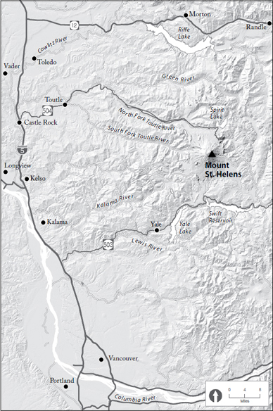
By the beginning of April, Mullineaux’s partner on the Mount St. Helens research, Rocky Crandell, also had moved from Denver to Vancouver to help with the crisis. The very afternoon that Crandell arrived, Mullineaux said that what he desperately needed was a map showing the danger zones around the volcano. Crandell found a Weyerhaeuser map of the Mount St. Helens tree farm, locked himself in an office, and the next morning emerged with a marked-up version of the map. It had three zones. One showed what might happen in the case of a small eruption, such as those that occurred repeatedly during the nineteenth century; one showed a moderate eruption; and one showed a worst-case eruption as large as any in the past 4,500 years. For such an eruption, Crandell predicted that avalanches could descend as far as Spirit Lake, five miles from the summit, and that pyroclastic flows would surge at least fifteen miles down the north and south forks of the Toutle River. Ashfalls could be more than three feet deep twenty miles from the volcano and a foot deep fifty miles from the volcano. This worst-case scenario became the basis on which many future decisions were made.
The rivers and towns west of Mount St. Helens
Crandell’s hazard maps immediately pointed to a major problem. The volcano was fast becoming a tourist attraction. People were traveling to Mount St. Helens not just from Washington State but from all over the world. Journalists came to the volcano to interview the locals and film the occasional eruptions. Television stations parked their microwave trucks—a recent innovation that allowed them to get on air almost immediately with breaking news—along the Spirit Lake Highway and in nearby towns. Local officials played up the volcano as a destination. Entrepreneurs near the mountain began to sell T-shirts, postcards, coffee cups, picture books, ashtrays made of volcanic ash, and anything else they thought visitors might buy.
Most of those who came to see the volcano went away disappointed. In the late winter and early spring, southwestern Washington State is one of the cloudiest places in the nation. The area around Mount St. Helens gets about ten feet of rain per year, and in the rainy season the mountain can be socked in for days on end. But every once in a while, if the sightseers were lucky, the clouds would part, the volcano would emerge, and a puff of steam-driven ash would rise from the peak. Amateur photographers began to set up on ridges and in clearings around the mountain where they could take photographs when the clouds lifted. Some began to sell their photographs, which got others interested. Now people had a commercial reason, besides their own curiosity, to come to the mountain.
While some of the locals profited from their souvenir stands, many were annoyed by the mountain’s sudden popularity. State and local officials were telling them that they would have to get out quickly if the volcano erupted. Yet as the roads filled with tourists’ cars, they knew they couldn’t get anywhere fast. “If we had to move a lot of the people out of here, how would we get past the sightseers?” asked one resident of the town of Yale. Tacoma’s News Tribune quoted an emergency official saying, “People are swarming in from all over, putting their lives in danger. . . . Sunday, when the weather was clear, the road up to the mountain looked like downtown Seattle at rush hour.” The airspace over the mountain was almost as bad. One afternoon, seventy aircraft full of media and sightseers were circling the mountain.
• • •
On March 27, when the first ash clouds rose from the mountain, law enforcement officials from Cowlitz County, in which the western approaches to Mount St. Helens are located, had set up a roadblock on the Spirit Lake Highway. But this was an odd kind of roadblock. It was designed to keep some people out but not others. For one thing, Weyerhaeuser was still logging the woods between the roadblock and the mountain, so Weyerhaeuser employees could go through. Scientists studying the mountain were granted free passage, as were journalists if they had permission to do a story closer to the mountain. Even homeowners, at the beginning of the crisis, could talk their way through if they made a convincing case to whoever was manning the gates.
Furthermore, the roadblock wouldn’t stay put. As warnings intensified, it would move farther away from the mountain. But then property and business owners would put pressure on public officials to move the roadblock back up the valley. Four times it moved up or down the Spirit Lake Highway, finally coming to rest about twelve miles down the road from Spirit Lake.
Even more important, the roadblock was only on the paved road. None of the logging or Forest Service roads that threaded the woods were cordoned off. In fact, a major gravel road paralleled part of the Spirit Lake Highway, since fully loaded logging trucks would quickly have demolished the highway’s asphalt. Many of the local people had used these gravel roads for years—to get to work, to go fishing or hunting, or just to get away for a day or two. Most households had pickups to drive those roads—as they do today—Ford F-250s and Broncos, Chevy Silverados, Dodges, even the occasional Toyota or rotary-engine Mazda. And many people in Washington and Oregon are used to driving on gravel roads to go camping, hunting, fishing, or hiking. Soon maps surfaced showing tourists how to take the back roads to get close to the mountain. Eventually the roadblocks became so expensive to man and so easily evaded that law enforcement officials didn’t even bother to station officers there. Anyone who wanted to get past the roadblock had no trouble doing so. Mount St. Helens was becoming even more popular as an incipient disaster than as a vacation destination.
EVERY DAY AFTER WORK, JOHN KILLIAN DROVE PAST THE VADER Tavern on the way to his home a few blocks from the Seattle-Portland rail line. Sometimes he stopped in for a beer, though not so much after he and Christy got married—he enjoyed his evenings at home with Christy too much to live like a bachelor again. But every once in a while he would stop in for a drink with his friends and coworkers. He needed to catch up with the news about the volcano.
In the spring of 1980, John was working for Weyerhaeuser on a road-building crew. Twenty-nine years old, lean and bushy-haired, he had lived in Vader almost his whole life, except for his time in the navy. His parents’ house was just a block from his own, and all three of his sisters lived in the area, along with his cousins and aunts and uncles and in-laws and other relatives. The Killians had been living in and around Vader for more than half a century, since John’s father had moved there as a boy. When John and Christy had children, they would raise them there too.
Before it burned to the ground in 1988, the Vader Tavern sat on A Street between two vacant lots where previous buildings had burned. The tavern was almost one hundred years old, with a magnificent solid-oak stand-up bar that had come around Cape Horn in the 1880s. The building had a false front, as did many of the remaining commercial buildings in Vader, and a sloped roof over a low wooden porch, so that it seemed more like a set for a western movie than a small-town tavern. People came from miles around to look at their reflection in the back bar, to watch the cascading neon beer signs, and to drink Rainier on tap, or Schlitz out of cans, or Coors all the way from Colorado if they were feeling rich.
Every small logging town around Mount St. Helens had taverns where the loggers met to drink and talk after work, and this is where, in April and May of 1980, the loggers argued whether it was safe to be working so near the mountain. Weyerhaeuser had moved many of its crews onto the hillsides and ridgelines so they wouldn’t be stuck in a valley if an eruption caused a mudflow. But some of the crews were working less than five miles from the mountain, and if anything the logging seemed to have intensified that spring, despite the economic downturn. Ash from the volcano mingled with the April snows, yielding a slushy gray mess. When an especially strong earthquake struck, the loggers would have to lower their chainsaws and lean against a tree trunk to remain standing. As usual, April was a cloudy month around the mountain. But every once in a while the clouds would momentarily part and the loggers would gaze at what the mountain had become. Like Mounts Rainier, Baker, and Hood, Mount St. Helens was named by the English explorer George Vancouver for someone he wanted to honor—in this case, an English diplomat named Alleyne FitzHerbert who was given the title of Baron St. Helens after forging an important treaty with Spain. FitzHerbert never saw the mountain, which perhaps is just as well, since his tenuous connection with the mountain and unusual title further reinforced its distinctly feminine aspect. The Indians in the area, whose ancestors had watched Mount St. Helens periodically erupt for many thousands of years and generally stayed away from it, always gave it female names: Loowit, which means “keeper of the fire”; Lawetlat’la, which means “the smoker”; or simply Si Yett, which means “the woman” in the Penutian language of the Yakima. Their legends spoke of an old woman whom the gods made young, reflecting the mountain’s geologic past. But now the mountain’s feminine nature was disfigured, as if an evil gray liquid had leaked from its tip, and on the north side of the mountain a strange disfiguration had appeared, a malignancy on the once-perfect cone.
The loggers at the Vader Tavern were of two minds about the mountain. Some were obviously worried about it. They didn’t say so very loudly, as they raised their beers to drink, for fear of being labeled cowards or shirkers. But they’d read enough in the papers and seen enough on television to know that if a major eruption occurred, they could be in serious trouble. Many of the loggers were familiar with the mountain’s past. Whenever a Caterpillar cut into a hillside to lay down a new roadbed, the roadcut would reveal multiple layers of ash. Some were thin, but others were a foot or two thick, with no seams to indicate that they were the product of more than one eruption. If the loggers were caught in an eruption like that, it would be difficult to escape. Their supervisors said they would have time to get away. But they’d seen the ash clouds billowing from the top of the mountain, and they’d heard the crackling and groaning of the mountain’s explosions. They wouldn’t be able to get away if they were caught inside one of those.
John and Christy had talked about it. She drove a forklift at Weyerhaeuser’s Green Mountain mill outside Toutle and was far enough away from the volcano not to be worried. But John was working just a few miles northwest of the peak. If the mountain blew, she wouldn’t know what had happened to him. John shrugged off her concerns. He’d been a boilerman in the navy, serving on the USS Badger, mostly off the coast of Vietnam, where the ship and its crew were assigned to cover operations on land and keep an eye on the Russian submarines patrolling in the South China sea. He knew every one of the 416 valves in the boiler room by heart. He was good around machines after a lifetime in the woods. They’d been fired upon lots of times in Vietnam, but he’d never come close to getting hurt. If the mountain did anything, he and his buddies would figure out how to get away.
Besides, they both knew that logging was a dangerous business. He and his coworkers had to take occasional risks in the woods; they had no choice, even though the cemeteries were filled with men who paid for those risks with their lives. The year after he graduated from high school, Herschel Bowers was killed when a limb fell out of a tree and ran him through the neck. Tom Galt was killed the next year when a crane hit a power line while he was holding on to a choker cable. Jim Mason, Richard Caywood, and George Rockett were all killed in 1975 by falling trees—that was a bad year. Ben Snow got run over by a bulldozer the next year, George Hack got crushed by a rootwad when he was bucking a windfall, Dee Bond was killed just last year felling timber right by Vader.
And those were just the men who’d been killed. Almost everyone working in the woods had been injured at one time or another. It was like the army guys in Vietnam—they just hoped when it happened that it would be enough to keep them out of the action but not too bad. John knew that Christy was aware of the risks—everyone in Vader was. But they couldn’t spend their lives worrying about what might happen.
• • •
In 1910, Vader, Washington—then known as Little Falls—was the largest city between Portland and Tacoma, with almost 5,000 residents. It sat in a broad valley surrounded by heavily forested hills that stirred the blood of every lumberman who saw them. From openings in the forest emerged gigantic trees, shorn of their limbs and bucked into railcar-sized lengths, which were loaded one per car to travel on the Northern Pacific line to mills in Tacoma or Portland. Most of the money generated from those trees went elsewhere, but enough stayed in Vader to create a brief period of prosperity.
The town had four hotels—the Stillwater, Spangler, Shelhorn, and Bannon—an opera house that doubled as a boxing arena, a hospital, five saloons, and a surrounding phalanx of churches. The largest building in town was the Little Falls Fire Clay Company, where 100 men made clay chimney pipes, flue linings, paving bricks, drain tile, and sewer pipe. The Stillwater Logging Company employed another 180 men at its sawmill by the rail line and at three logging camps in the woods. People looking for good jobs in factories or logging in the woods flooded into the town, including many from the depressed logging states of North and South Carolina.
In 1913 the Northern Pacific objected to the name of the town, saying that a Little Falls already existed on the company’s rail lines in Minnesota. For a replacement, the townspeople chose the name of a popular resident, Martin Vader. But the new name seemed to bring ill fortune. That same year, the Weyerhaeuser Company bought the Stillwater Logging Company and shut down the sawmill, laying off hundreds of workers. The next year the brick factory burned to the ground, leaving only its smoldering chimneys and kilns.
Soon the town entered into a dark period. The townspeople began buying insurance for their homes and then setting them afire. A resident described in a letter approaching the town one night and seeing the distant glow of burning houses. The hotels and saloons closed, and then the shuttered churches began to burn.
In 1929, John Killian’s father, Ralph Killian, moved to the vicinity of Vader from North Carolina as a nine-year-old boy. The town was already in decline, but the Killian family endured, partly because they were surrounded by other families that were facing the same struggles. During World War II, Ralph was a first-class petty officer in the navy, after which he returned to Vader and took a job with Weyerhaeuser. It was a good job, a union job, and he moved slowly up the ranks, from choker setter to rigging slinger to crew boss. He was a tough boss but fair, with a streak of sympathy for the men who were doing the jobs that he used to do.
Meanwhile, the town of Vader continued to fade. Over time it took on a curious gap-toothed appearance, with just a few houses still standing on each large block. It still had a few businesses—a general store, the tavern—but the only place left to eat was the Little Crane Café, which occupied the sole remaining structure left from the Stillwater Lumber Company, a square shack right next to the railroad tracks that used to house tools and spare parts for the mill. Around the town the hills acquired the curious shorn look of many logged areas in the West. Traditionally, such hillsides are said to look like they’ve had a bad haircut, but actually it’s more like a haircut by a madman: the boundaries of cutover regions have no obvious design or rationale, with only the occasional single standing tree to remind onlookers of what once was there.
As businesses and houses continued to burn, the town’s population dropped—from 5,000 to less than 1,000 by 1980. Nevertheless, the Killians stayed on. Other members of Ralph’s family from North Carolina joined him in Vader, and they married into local families and began to have children. Over the decades an extended network of interrelated families took shape not just in Vader but in the nearby towns too. No matter where you went in Vader, Toledo, Ryderwood, Winlock, Castle Rock, or Toutle, everyone knew the Killians and their kin. They were part of the country around there just as much as the hills and streams were.
IN APRIL THE GEOLOGISTS MONITORING MOUNT ST. HELENS, LIKE the loggers working around the mountain, realized that the shape of the volcano was changing. A large bulge had formed on the north side of the mountain. It was about a mile from top to bottom and a little over half a mile across. It stretched and fractured the glaciers on the side of the mountain, so that they took on a curious blistered appearance, and it continued to grow. Each day, the bulge expanded outward by about five feet. “A major deformation like this is pretty extreme,” Dave Johnston told a newspaper reporter. “It surprises us, to be quite honest. It’s not that it is totally unexpected, but it is a pretty major change in the shape and size of the volcano.”
By this time, an eclectic group of geologists had gathered in Vancouver and other towns around the volcano. Several volcanologists who had worked at the Hawaiian Volcano Observatory on the Big Island flew to Washington State to help monitor Mount St. Helens, including Don Swanson, Jim Moore, and Pete Lipman. Bob Christiansen from the Geological Survey’s Menlo Park, California, office oversaw the monitoring effort, while Dan Miller and Rick Hoblitt from the Denver office assisted Crandell and Mullineaux. Richard Waitt analyzed ashfalls, and Thomas Casadevall helped Johnston track volcanic gases. Meanwhile, other geologists and seismologists not associated with the USGS came to southwestern Washington to inspect the volcano and make predictions about what could happen.
Since his press conference the day after the first eruption, Johnston had been more worried than many of his colleagues about the dangers posed by the volcano. He and a few of the other geologists had begun talking about the similarities between Mount St. Helens and another volcano, Mount Bezymianny, which is in Russia on the Kamchatka Peninsula a thousand miles northeast of Japan. In September 1955, earthquakes began to shake Mount Bezymianny, and three weeks later the mountain erupted just as Mount St. Helens had erupted at the end of March, with steam and ash as the volcano heated up. Then the mountain quieted for several months, though the earthquakes continued. Suddenly, on March 30, 1956, the volcano violently exploded, devastating areas almost twenty miles away. But what was unusual about Bezymianny is that the volcano did not explode straight upward, as in the conventional image of an erupting volcano. It exploded sideways, ripping the side off the mountain and destroying everything in that direction while leaving the rest of the countryside unscathed. If something like that happened at Mount St. Helens, Johnston told the other geologists, the destruction would be immense.
The geologists had been monitoring the volcano from the Timberline parking lot on the north flank of the mountain, but they needed another vantage point if Timberline became unsafe. Early in April, a state snowplow cleared a path along logging roads to an old landing above Coldwater Creek, where the geologists erected a canvas tent on a wooden platform. As early spring snows continued to fall on the ridge, they warmed themselves around a fire barrel that Ralph Killian had donated. They called it the Coldwater observation post.
By the second week in April, Rocky Crandell was sufficiently worried about the north slope of the volcano that he decided he needed the help of an expert. He talked with Barry Voight, a respected landslide geologist at Penn State University, and asked if he would come take a look. Voight was a member of an unusual family. One of his brothers was the actor Jon Voight, whose daughter, Angelina Jolie Voight, was four when Mount St. Helens began acting up. His other brother, who went by the stage name Chip Taylor, was a musician best known for writing “Angel of the Morning” and “Wild Thing.” But Barry Voight was a scientist through and through: meticulous, thorough, and sometimes brusque in presenting his results and opinions.
On April 10, Voight flew to Portland, rented a car, and drove to Vancouver, where he attended the regular morning meeting of the geologists to discuss the volcano’s behavior. The next day he drove up the Spirit Lake Highway and set up a camp about a half mile east of the Coldwater observation post. He sat down on a bedroll with a notepad and binoculars and began to study the mountain. It was a fearsome sight. Gigantic cracks pierced the ash-covered glaciers on the north and west slopes. Something was causing the mountaintop to split, but whether it was magma pushing up from below or deformation of the rocks caused by the heated groundwater, Voight couldn’t tell. On his notepad, he sketched out some hypotheses of what might happen. If the bulge gave way, could a large avalanche occur? He did a quick calculation of the size of a potential landslide. It would be huge, so large that it would easily reach Spirit Lake. He wrote a note to himself: “Recommend not opening the Spirit Lake area.” And then “Surge wave in lake, if rockfall reaches lake, runup on far shore.”
What if pressure was building up inside the mountain and a landslide suddenly released it? Voight wondered. Could a pyroclastic flow follow in the same direction as the avalanche? Such an eruption could be similar to that of the Mount Bandai volcano in Japan, which exploded sideways in 1888, killing more than 450 people and devastating the region to the northeast of the volcano.
Voight stayed on the mountain for two days, finally breaking camp when the clouds and rain returned. The next day he drove back up to the Timberline parking lot, where he told the geologists working there that they were in a very dangerous spot. If a landslide came down the north side of the mountain, it could kill them all and unleash a pyroclastic flow directed right at Spirit Lake. Voight spent a few more days in Vancouver and around the mountain, helping with various tasks and telling anyone who would listen about the landslide dangers. He posted on the walls of the office a scaled drawing of the mountain’s cross-section, showing the huge prospective landslide and its relation to the observed surface cracks. Then he returned to Pennsylvania to write a report on what he had observed. “The principal hazard at Mt. St. Helen’s during the period of my observations (11–19 April, 1980) involved the potential instability of the north slope,” he wrote. If the slope gave way, the resulting landslide “could be as much as a kilometer thick and involve a cubic kilometer or more of rock and fragmented material.” Moreover, the release of the underlying pressure from the avalanche “would likely promote further explosive activity (flashing) in hydrothermal systems occupying the core of the volcano, the surrounding porous edifice, and perhaps also in shallow magma chambers. A catastrophic event of the kind observed at Bandai-San . . . must be regarded as a legitimate possibility.”
Voight’s observations and recommendations generated intense discussions among the geologists. But in the end his speculations about a lateral blast were treated as just one more possible scenario. Everyone had ideas about what could happen at the volcano. They argued their positions at the daily scientific meetings in Vancouver, but without more data, no viewpoint could prevail. The historical record compiled by Crandell and Mullineaux was still the primary source of information for the geologists. But their careful research could be misleading too. They had reconstructed the volcano’s history over several thousand years, but Mount St. Helens was a very young volcano, and during its short life it had exhibited many kinds of behavior—sometimes it oozed hot lava down its flanks, sometimes it sputtered and smoked for decades on end, and sometimes it erupted explosively. Mullineaux and Crandell based their forecasts on what their studies had revealed about the past. For Mount St. Helens, however, the past was not necessarily a reliable guide to the immediate future. As Crandell told a newspaper reporter in April, “Mount St. Helens has done so many things in the past that hardly anything would be a surprise. The only thing it hasn’t done is blow itself apart.”
The same day that Voight set up his tent and folding chair near the Coldwater observation post, the director of the Geological Survey, a man named Bill Menard, came from Washington, DC, to see the mountain for himself. After a briefing in Vancouver, Mullineaux and a retinue of geologists proceeded to the Timberline parking lot. For the last few weeks, with the cloudy weather and all the work he had to do in Vancouver, Mullineaux had seen very little of the volcano. But standing with Menard on the north flank of the volcano and looking up to the bulge, he was shocked. He knew the volcano better than anyone in the Timberline parking lot. The geological forces that it must have taken to produce that bulge were immense.
No one should be here, he thought. “I had been there many times, but from the [aerial] pictures I had not understood how much change had taken place and how threatening that thing looked. It looked like a failure was about to occur. The bulge was terrifying. I wanted to turn around and leave.”
• • •
By the end of April, the bulge had become the geologists’ greatest concern. An April 25 press release from the Forest Service revealed that the bulge had raised the side of the mountain 300 feet above its original contour and was continuing to expand. It could not go on growing forever. Eventually it would have to collapse down the north side of the volcano. Crandell calculated what the failure of the bulge could do. It would flow over Timberline and into Spirit Lake, where it would generate a large wave that would slosh up the far side of the basin and drown anyone still around the lake. The landslide and water displaced from Spirit Lake then would course down the north fork of the Toutle River, sweeping away whatever it encountered. “The probability of an avalanche cannot be quantitatively determined, but such an event must be regarded as a distinct possibility and probably the most serious hazard yet posed by the current eruption up to this point,” Crandell wrote in a letter to forest supervisor Bob Tokarczyk.
Other geologists were more guarded in their warnings. A large avalanche from the bulge “would be a pretty extreme scenario,” Dave Johnston told the Associated Press in an article published on April 29, “but it could happen. It could be a catastrophic release of a very large volume, in which case I wouldn’t want to own a house up there, or it might be a piecemeal bit-by-bit collapse that would be dangerous primarily on the flanks of the volcano.” Yet Johnston and his colleagues were still working in the Timberline parking lot, which certainly would be wiped out by an avalanche of any appreciable size. Johnston was even flying into the crater occasionally to collect gas and water samples, after which he would sprint back to the helicopter and quickly fly away.
Besides recognizing the dangers posed by the bulge, the geologists in Vancouver were aware that an avalanche could trigger an even greater disaster. On May 6, for example, the Tacoma News Tribune carried an article featuring an interview with a local geologist named Jack Hyde, who was not associated with the Vancouver group. “I have a gut feeling . . . that as the bulge continues to grow, something dramatic is going to happen,” Hyde said in the article. If the north slope gave way, a “spectacular” explosion could occur without warning. “The blast from the explosion of a Soviet volcano in 1956 blew down trees 15 miles away,” he said, adding that Mount St. Helens could do the same. When Hyde was asked by the interviewer about the geologists watching the mountain from nearby observation posts, he said, “I hope they’re not in a direct line. That’s like looking down the barrel of a loaded gun.”
Yet the geologists in Vancouver continued to monitor the volcano from its northern flank. Partly they were used to taking risks. It was their job to warn others if an eruption began. The closer they were to the volcano, the faster they could issue an alarm.
The geologists also had different experiences with volcanoes. Many had worked previously at the Hawaii Volcano Observatory, which is perched on the edge of the Big Island’s Kilauea volcano. The volcanoes in Hawaii typically erupt a very different kind of lava than do the Cascade volcanoes. The basaltic lava in Hawaii, which is derived from a hot spot beneath the Pacific tectonic plate, has the consistency of raw honey when it erupts. Fed from summit vents or rifts that split the flanks of volcanoes, the lava flows downslope in pulsating streams. Explosive eruptions are infrequent, and the risk to human life from such eruptions is low.
The magmas that have created the Cascade volcanoes generally have a different consistency. As they make their way to the surface of the earth from the subducting oceanic plate, they often lose iron- and magnesium-rich crystals and gain silica from the melting of continental rocks. By the time the magma erupts, it has a consistency more like road tar than honey. This kind of magma can form stiff, sticky plugs in volcanic vents that bottle up the gases and pressure in a volcano. When the blockage gives way, explosive eruptions can result. The Hawaiian volcanologists had studied other kinds of volcanoes, but they were much more familiar with gradual eruptions of red-hot basalt than they were with explosive subduction-type volcanoes.
However, the volcanologists in Vancouver did share one belief, which gradually made its way into the public consciousness. They thought that some kind of warning would precede a major landslide or eruption. The bulge would start slipping, or earthquake activity would pick up, or sulfur emissions would increase, or new hot spots would appear on the volcano’s flanks. As Mullineaux said, “There is a good chance we would have warning before a serious eruption” (though he added that “a slide could go without any warning signals”). By the beginning of May, the volcano was being monitored in several different ways, any of which might give warning of an impending disaster. Geologists were measuring the movement of the bulge from the Timberline parking lot. Seismometers around the mountain were feeding their signals to Steve Malone and the other seismologists at the University of Washington, who were conveying the information to Vancouver. Sensitive gravity stations and magnetometers were seeking subtle changes inside the earth. Planes were flying overhead and taking photos when the weather was clear, and some of them were equipped with infrared cameras to take images of hot spots on the mountain. Dave Johnston and other geochemists were looking for sulfur in the gases and water being released from the mountain. The warning that scientists expected to get from these measurements might not be much—maybe just a few hours or minutes. But it would give the people around the mountain at least a head start on some of the more dire scenarios discussed during the morning staff meetings.
On the wall of his office in Kelso, Cowlitz County Sheriff Les Nelson had a drawing of a broken-down cowboy with a caption reading “There’s a hell of a lot of things they didn’t tell me about this outfit when I hired on here.” Nelson looked at that drawing often in the spring of 1980. Certainly if he ever ran for sheriff again, he’d make sure it wasn’t in a county next to an active volcano.
Nelson had the job of keeping the people in his county safe; he spent most of his time dealing with people who’d found ways to be unsafe. He’d been a ranch foreman in Colorado before moving to Washington, where he went to work in the logging camps around Mount St. Helens. He’d gotten into sheriffing because he liked people and people liked him, and he thought of himself as a lot more sensible than many of the people in his county, so it made more sense to have him watching over them rather than the other way around. But compared with the garden-variety car crashes, drownings, and shootings he dealt with every day, this volcano was in a completely different category. He’d sat in meetings with the geologists and heard them describe the avalanches and mudflows coming down the valleys and the clouds of hot asphyxiating gas. The other people in the meetings—the people who worked in offices all day—didn’t seem to take the warnings seriously, but Nelson had seen what two tons of metal can do to a person, much less a wall of mud twenty feet high.
Everybody was unhappy with him and his officers. At the barricade on the road to Spirit Lake, drivers would yell at them, “This is a free country.” “I have a right to go up to my property.” “I’m going to call my attorney.” The restaurant and motel owners on the far side of the barricade howled about government taking away their freedom while the owners on the near side raked in more money than they had ever seen in their lives. The state hadn’t made things any easier. It had closed the Spirit Lake Highway, but it hadn’t closed any of the surrounding logging roads. All people had to do was buy a map from a gas station or convenience store and they could go anywhere they wanted. The sightseers weren’t breaking any laws, no matter how foolish they might be. There was nothing Nelson or his deputies could do about it.
The geologists weren’t much help. He’d once told a journalist, “Trying to pin down a geologist [is] like trying to corner a rat in a rain barrel,” and even though that was probably too harsh, he thought it at the time and he still thought it. They were being way too cautious. If the geologists would just say that these people were going to die if that bulge gave way, at least they would be telling the truth, and he wouldn’t have to be the one to say they were putting their lives in danger. Of course, people wanted to put their lives in danger—every sheriff knew that. But when the inevitable happened, and someone got hurt, there’d be hell to pay.
Besides, the press was worse than the geologists. They were the ones flying helicopters onto the crater rim like they were descending on some accident scene to interview the survivors. Sometimes they helped by scaring people with stories about red-hot lava and ash clouds that would bury a person in his tracks. But as often as not their stories just made the more adventuresome types want to get closer to the volcano. And word was getting around that money could be made by taking photographs of the volcano from as near as a person could get. Nelson had seen cars with Seattle and Bellevue license-plate frames that were filled with camera equipment turning off the highway onto logging roads, and he knew they could drive all the way to the flanks of the volcano without interception. It was making the logging truck drivers crazy, because they’d be barreling downhill on a narrow, crumbly dirt road and would suddenly encounter a station wagon crawling in the opposite direction straight from some suburb. Somebody was going to get killed out there, the truck drivers said, and it wouldn’t be their fault.
But the worst thing about the press was their love affair with the outlaws. Reporters were making heroes out of the people who were loudly defying Nelson and his deputies, which was making it impossible for Nelson to do his job. An octogenarian named Harry Truman was by far Nelson’s biggest problem. From the day after the first eruption, the press had been writing stories about Harry refusing to leave his lodge on Spirit Lake. “I stuck it out 54 years, and I can stick it out another 54,” Harry had loudly proclaimed, a glass of Coke and Schenley’s whiskey in his hand. He might have left if the papers hadn’t written stories about him. But now he had his image to uphold.
Nelson felt some sympathy for Truman. He’d been running the Mount St. Helens Lodge since he gave up bootlegging in the 1920s, not long after his father was killed in a logging accident near Chehalis. He’d built that lodge up from almost nothing. He and his wife, Eddie, hosted hundreds of people each summer. He’d become friends over the years with famous people, including Chief Justice William O. Douglas and the Burlington Northern officials who stayed at the lodge each summer, since the lodge was built on land leased from the railroad.
But five years earlier Eddie had suddenly died in the lodge after going upstairs to take a nap, and that had broken Truman. He was so angry and mean that people around the lake tried to avoid him. The lodge stank of piss from his sixteen cats. The papers couldn’t print half of what he said, since mostly what he did was swear. Still, journalists loved to take pictures of him drinking in his kitchen, or sitting at his player piano, or gesturing at the mountain above his lodge. They’d fly in to the lodge to interview him and bring him more Schenley’s, and some reporters had told him that they’d bring him out in a helicopter if the mountain blew. Hell, look at that mountain, Nelson thought. If that thing gave way, Truman wouldn’t have time to get one pant leg on before he’d be dead. There couldn’t be a worse place to be. Truman thought the trees were somehow going to block all that rock and snow from descending on him, as if he’d never seen an avalanche up there. He’d told the press, “The mountain will never hurt me. When you live someplace for 50 years, you either know your country or you’re stupid.”
The problem was, if Nelson let Harry Truman stay at his lodge, then everyone else would point at Truman and say, Well, why not me too? The press and the people making money from selling their photos would just tell Nelson that they were doing their jobs. There was no law against that. Already he and the other sheriffs in the area were getting huge pressure from the cabin and resort owners on Spirit Lake who wanted to get to their properties. They couldn’t make an exception for Truman and not make an exception for other people.
But it wasn’t just Truman, Nelson knew. It was the loggers too. Hundreds of loggers were up there every day working, though many of them weren’t happy about it. With the loggers in the woods, it didn’t make sense that other people couldn’t go in. No real laws covered the volcano. People were making it up as they went along.
It couldn’t last, Nelson knew. Something had to give. As he told a reporter at the end of April, “I never wanted to be wrong about anything more in my life, but there’s pressure being built up inside that mountain, and it’s got to come out somewhere.”
IN THE SPRING OF 1980, JOHN KILLIAN’S JOB WAS TO SET CHOKERS behind a Caterpillar on a road-building crew about ten miles northwest of Mount St. Helens. Setting chokers is one of the toughest and most dangerous jobs in logging. Your job is somehow to get a metal cable as thick as a man’s thumb around the trunk of a fallen and de-limbed tree. Once the cable is looped around the tree, you attach the other end of the cable to a separate line that leads to a clearing in the forest. You signal with a whistle or walkie-talkie to the rigging slinger, and the tree is dragged by a winch or a Caterpillar to the landing to be loaded onto a truck. Then you do it all over again.
Ken Kesey has a great description of choker setting in his novel Sometimes a Great Notion. Lee, the bookish, high-strung younger brother, has returned to his childhood home on the edges of the great coastal forests of Oregon to help with a massive fall harvest:
The next log has fallen on a clear, almost perfectly level piece of ground. Unhampered by vines or brush, Lee reaches the log easily. . . . But the very flatness of the ground beneath Lee’s log presents a problem; how do you get the cable under it? Lee hurries along the length of the big stick of wood all the way to the stump, then crosses and hurries puffing back, bent at the waist as he tries to peer through the tangle of limbs lining its length. . . . But there is no hole to be found: The tree has fallen evenly, sinking a few inches into the stony earth from its butt to its peak. Lee chooses a likely place and falls to his knees and begins pawing at the ground beneath the bark, like a dog after a gopher. . . .
By lunchtime, Lee is thoroughly exhausted:
Lee allowed himself to sink to the ground beside a stump. . . . [He] had removed the heavy shirt to let the breeze dry off his sweat; the sweat wasn’t much affected as he tugged, jerked, and hauled the unwieldy cable through a miasma of berry vine and fire slashing, but within a half an hour both arms were quilted from glove top to shoulder with a pattern of welts and scratches. The view he had of his stomach made him think of fabric instead of flesh, a bright garment of patchwork skin stitched together with thorns. . . .
He felt sick. . . . He wouldn’t move from the spot, though his leg was twisted painfully beneath him, though those bastard carpenter ants, big and shiny as carpet tacks, crawled through his shirt and across his sweating belly, and though he was sitting in a thicket of what was surely poison oak—what else?
John Killian worked hard for the Weyerhaeuser Company. One evening, after setting chokers all day, he told his mom, “I did good for George today.” Except for his time in the navy, John had worked most of his adult life for Weyerhaeuser. It was the logical job for him to take. His father was a twenty-year veteran of the company. Jobs were plentiful back then, when the big trees up by Mount St. Helens were just waiting for the loggers and their saws. All he had to do was go down to the union hall and sign a few papers and he was as good as hired. Pretty much everybody around Vader went to work in the woods or in the mills, whether for Weyerhaeuser or for another company.
But by the spring of 1980, John could tell there was no future working for Weyerhaeuser. The old growth was running out fast. They’d have it all sawed down within a few years. Then the number of jobs in the woods would start falling. The old-timers like his dad would hold on to the best jobs, which meant there’d never be a chance for John to move up to rigging slinger or yarder operator. He’d be stuck setting chokers for years, assuming he could even hold a job, and not many people lasted in this job for long. He’d get hurt, or his body would wear out, or he’d just get tired of clawing through the snowberry and sword ferns and blackberry brambles.
John was making good money working a union job for Weyerhaeuser—$22,000 a year, if he could work the whole year—and Christy was making decent money driving a forklift in the Green Mountain mill. (Adjusted for inflation, John would be making more than $50,000 today.) But that wouldn’t last. They were trying to have a baby. Christy would probably be pregnant soon and would have to stop working. And he could tell that Weyerhaeuser was going to start cutting back on union employees and transfer more of the work to independent contractors. It was cheaper for the company to hire gyppos and not pay union wages and benefits. Already, most of the fallers working on the ridges around the mountain were contractors. It was the way the business was going.
John and a friend had talked about going out on their own as contractors for Weyerhaeuser. You could make more money, if you worked hard and if there was work to be had. And he would need the money to do everything he wanted to do. He’d saved enough to buy some land out in the woods by Toledo. But he’d need more to start building a house, even if he used his friends to get the foundation poured and the framing done.
It was a risk, leaving the security of a union job behind. But John was used to taking risks. Once he and his friend Al Bates had been hunting elk west of Vader, up in the second-growth forest by the Grays River divide. He’d followed a buck and two does upriver, keeping the stream between him and the elk so they wouldn’t hear him. The land headed steadily uphill, John on one side of the stream and the elk on the other, and the streambed narrowed and dropped into a deep gorge. It got rocky, and John had to scramble to keep the elk in sight and his rifle out of the mud. Then the elk veered away from the stream, and John knew that he’d lose them unless he got across. But the stream was now at the bottom of a deep canyon so narrow that the walls on either side almost touched. He’d have to jump it. He looked for a place where the canyon walls were close together and quickly found a spot. It should be easy to get across, he figured, just eight or nine feet of empty air. He threw his gun to the other side—now he had no choice. He backed up to get a running start, hurrying, since he knew that the elk were getting farther away. He sprinted toward the canyon, worrying just for a moment when his jumping foot landed two feet short of the edge, because that meant he’d have even farther to jump, and then he was up in the air, with nothing below him for at least a hundred feet. It was an odd sensation, as if he were flying, as if he were weightless while the world turned beneath him. But just as quickly he landed on the other side, dropping to one knee. Breathing hard, he picked up his gun and hurried after the elk.
BY THE MIDDLE OF APRIL, THE FOREST SERVICE REALIZED THAT IT needed a better way of controlling access to areas around the mountain. The area above Timberline had been closed since the first earthquakes, and a roadblock on the Spirit Lake Highway kept people off the one paved road on the mountain’s west side. But the woods around the mountain were full of people who had taken gravel roads to their destinations—loggers, photographers, reporters, scientists, law enforcement personnel, and sightseers who just wanted to be near an erupting volcano.
The group of public officials and industry representatives who had met in Vancouver on March 26 had continued to meet since then, and that group took on the task of devising an access system for the mountain. Within the Forest Service, the job fell primarily to Ed Osmond, a twenty-three-year veteran of the agency who had transferred just a few months earlier to the Gifford Pinchot National Forest from a national forest in Oregon. With a small group of colleagues, Osmond took a set of Forest Service maps and started drawing lines around the volcano. They began by drawing a line across the first ridgeline north of the mountain, just above the north fork of the Toutle River and Spirit Lake. The line then turned north and extended through a high point of land known as Mount Margaret. As Osmond said later, “We did not think anything would go beyond Mount Margaret ridge in any way, shape, or form. We thought any type of event would be contained in the physiographic basin.” The land through which this line passed was within the Gifford Pinchot National Forest, though Weyerhaeuser, Burlington Northern, and a few other companies still owned scattered square-mile sections inside the national forest. But most of their land was north of the line, so they wouldn’t complain.
To the east of the volcano, Osmond and his colleagues carried the line down a ridge between Smith Creek and Bean Creek, figuring, as on the north side, that the ridgeline would block the force of any eruption. On the south, the line followed a road that provided access to some of the southern climbing routes to the mountain. It was a bit close to the volcano, but putting it any farther south would place off limits some of the rich forestlands being harvested by the Forest Service and private companies.
The problem was on the volcano’s western and northwestern sides. On those sides, Weyerhaeuser owned almost all the land outside the national forest. But the boundary between the national forest and Weyerhaeuser land, which ran north-south along a county line just to the west of the mountain, was less than three miles from the peak. Osmond and his colleagues felt that they could not draw their line onto Weyerhaeuser property, because they did not think they could force Weyerhaeuser to remove employees from its own land. So on the western and northwestern sides, they simply followed the boundary between the national forest and Weyerhaeuser’s property.
Everything inside this line, Osmond and his associates called the red zone. Only scientists and law enforcement personnel were allowed into this area. True, Harry Truman was holding out at his lodge on Spirit Lake, which was solidly in the red zone, but he would have to be an exception.
Outside the red zone, Osmond and his colleagues drew another line that generally followed roads ten or so miles away from the volcano’s peak. The area between the two lines they called the blue zone. Here loggers and property owners could enter during the day if they had permission, which generally meant acknowledging the risks they were taking. But a problem again arose on the western and northwestern sides of the volcano. Extending the blue zone into Weyerhaeuser property would mean extending the Forest Service’s jurisdiction onto private land, and Osmond felt that they couldn’t do that. Therefore, on the western and northwestern sides of the volcano, there was no blue zone.
It made for an odd-looking hazards map. On the northeastern, eastern, and southern sides of the mountain, the red and blue zones extended out about five and ten miles, respectively, from the smoldering volcano. But on the western and northwestern sides, the danger zone was curiously squashed. The map looked like a pie out of which someone had cut a large slice. And by an unfortunate coincidence, the bulge on the volcano was pointing almost directly at the area where the danger zones were thinnest.
The geologists and law enforcement personnel were not happy with the danger zones. As Crandell said later, people “wanted the zone to extend as far out as possible, as long as it didn’t include their lands.” One state patrol captain put it this way: “If this isn’t Weyerhaeuser and county politics, it makes no sense at all.”

The red and blue zones to the north of the volcano
Other groups besides Weyerhaeuser would have objected if Osmond and the others had drawn the lines for the red and blue zones any farther west. One of the biggest interest groups was the state of Washington itself. Weyerhaeuser owned much but not all of the land between Mount St. Helens and Interstate 5. The state also owned valuable land left over from the land grants, and it had become dependent on that land. The Washington State constitution says that proceeds from state timber sales are to be distributed to local school districts to help pay for construction costs. Timber sales had brought in $175 million for public education in Washington the year before (the equivalent of about a half billion dollars today), and in a state without an income tax, that money was desperately needed. As the head of the state’s Department of Natural Resources, Bert Cole, said after the eruption, “We were anxious to continue to harvest timber. . . . We were concerned about the safety of lives, too. But we had timber sales going on in there that had to be taken care of.”
Only one person could extend the danger zones into Weyerhaeuser territory—the governor of Washington State, a woman named Dixy Lee Ray. Born Marguerite Ray to a working-class family in Tacoma (her father was a commercial printer), she’d been a tomboy growing up and was often called “the little dickens,” which gradually became Dixy. At sixteen she legally changed her name to Dixy Lee Ray, commemorating her tumultuous childhood and a family connection to the Civil War general. Always fascinated by the animals she discovered in the tide pools and waters of Puget Sound, she received a bachelor’s degree in zoology from Mills College in Oakland and a PhD from Stanford University in biological science. She worked her way through college as a puppeteer, janitor, waitress, and housepainter. She said, “I missed a lot of sleep in those days, but never a class.”
She was a biologist on the faculty of the University of Washington for more than twenty years and then the director of the Pacific Science Center in Seattle, which was built for the 1962 World’s Fair and had a profound influence on many science-oriented kids in the Northwest. In 1972, Richard Nixon appointed her to serve on the Atomic Energy Commission, and she became chair of the commission the next year when former chair James Schlesinger was named head of the Central Intelligence Agency. She had always been adamantly pro-nuclear, though her expertise was in marine biology rather than nuclear science. She also had a tendency to say exactly what she thought, even if it wasn’t true. For example: “There is no evidence that survivors of the Hiroshima bombings have suffered any more cancer than anyone else, including the second generation. The problems facing the nuclear industry are largely raised by fears of the public, but we all know that fear requires ignorance.” She made headlines in Washington, DC, for living in a motor home in rural Virginia, wearing white knee socks, and bringing her Scottish deerhound and miniature poodle to work.
In 1975 she returned to Washington State and decided to run for governor. Never much interested in party politics, she filed as a Democrat since the Republican slate was already full. It was the election after the Watergate scandal, and Ray swept into office with many other newcomers and outsiders, including Jimmy Carter. When asked on election night to explain her success, she replied, “It can’t be because I’m so pretty?”
During her time as governor, Ray lived in the governor’s mansion with her dogs, although she tried to return to her mobile home on nearby Fox Island on weekends. She quickly drew criticism from her new political party for her conservative views, especially on environmental and energy issues. She sought to permit oil supertankers to offload in Puget Sound but was blocked by Sen. Warren Magnuson, sparking a feud that continued for years. She also lost favor with many women supporters when she refused to campaign for the Equal Rights Amendment to the United States Constitution. Quick to anger, she engaged in legendary feuds with the news media. In 1978 she named a litter of eleven piglets born at her Fox Island home after various reporters. The next year she treated reporters to sausages made from those pigs.
When the first phreatic eruption occurred on Mount St. Helens on March 27, Ray was addressing a meeting of Washington Superior Court judges in Port Ludlow, an old timber town on Puget Sound. “I might just read you the note that has just been handed to me,” she told the assembled judges with a grin. “We have received information that Mount St. Helens has erupted at 12:58 today. . . . I’ve always said, for many years, that I hoped I lived long enough to see one of our volcanoes erupt. Maybe soon I will get a chance.” After the speech, she went directly to a nearby airport and had a plane fly her to the mountain, after which she reported, “It was really quite a thrill. . . . No lava, [but] the top is quite dirty.”
Toward the end of April, the state Department of Emergency Services forwarded the map prepared by Osmond and his colleagues to Ray with an urgent request from local law enforcement that she establish the red and blue zones in state policy. The map was obviously deficient. Ray knew that people were using logging roads to get way too close to the mountain on the western and northwestern sides. But she, like Osmond, did not want to extend the red or blue zones onto Weyerhaeuser property. “You cannot restrict or remove people from their homes or prevent them from earning a living unless you have awfully good reason,” she later said. The proposed map’s failure to impose any restrictions on Weyerhaeuser’s land gave Ray and her aides an excuse not to do so either.
But that decision had major consequences. Without an extension of the red or blue zones to the west or northwest, the people entering those areas were doing nothing wrong and could not be told by law enforcement to leave. Evidently, to Ray, they were on their own and should have known better. “It’s just impossible to believe that there could be anybody who didn’t realize that coming close to the mountain was hazardous.” On April 30, she issued an executive order that simply adopted the red and blue zones developed by the Forest Service. It was an act that would have dire consequences.
• • •
Toward the third week of April, about the same time the public learned about the bulge on Mount St. Helens’s north slope, the worst possible thing happened: the mountain began to quiet down. The number of earthquakes and steam and ash eruptions fell, though the intensity of the quakes was greater, so that the total seismic energy shaking the mountain was about the same. But the mountain was strangely still. Only the bulge was active, growing and expanding until the north face of the mountain became grotesquely bloated and cracked.
That same week, on April 24, the US military had launched a rescue attempt of fifty-three hostages in Iran that went terribly wrong. Of eight helicopters that took off from the Nimitz aircraft carrier off the coast of Iran, only six made it to a staging area in the desert four hundred miles southeast of Tehran, and another one had a mechanical failure when it arrived. In a move still debated in military circles today, President Carter agreed with the commander that the mission should be aborted. Then, as one of the helicopters was being moved for refueling, it hit a troop plane, causing an explosion and fire that killed eight servicemen. Five helicopters were left behind in the retreat, some of which contained the names of Iranians working for the Americans. The debacle sapped US prestige and contributed to the outcome of that fall’s presidential election.
The press, distracted by the hostage crisis and the election, began to lose interest in Mount St. Helens. The press conferences in Vancouver fell from three a day to twice a week, and by the beginning of May they ended altogether. The geologists would record a message onto a telephone answering machine, and any reporters writing stories would call in to learn what was happening.
As the mountain got quieter, several groups affected by the red-zone restrictions got louder. The loudest was the group of people who owned homes and operated resorts around Spirit Lake and the north fork of the Toutle River. The roadblock on the Spirit Lake Highway seemed designed only for them. Loggers were still working on the ridges right next to Spirit Lake, and the hills were filled with photographers, geologists, and sightseers, but the property owners who had the most at stake in the land couldn’t go to their homes. In Washington State, property tax bills are sent out in April, and the arrival of tax bills in the mail raised new howls of protest. The state wouldn’t let property owners near their homes but it still expected them to pay taxes on those homes. The property owners knew that snow avalanches in the winter rarely got past the Timberline parking lot, and they certainly never reached Spirit Lake. Why should a rock avalanche be any worse?
Some of the loggers working for Weyerhaeuser also were agitated, but for the opposite reason. On the rare occasions when the weather cleared and they saw the bulge on the mountain, they knew they were working in a dangerous spot. Maybe the rocks distended by the bulge would drop harmlessly into the Toutle River valley, but that was the road they took to get home every night. Weyerhaeuser had written an emergency plan that kept them up on the ridgelines, along with the sightseers and scientists. But they knew that those ridgelines had been covered with ash in the past, and they didn’t want to be there when it happened again. Some of the loggers were working on the ridgeline just to the north of the mountain along which the red-zone boundary ran. If the red zone was too dangerous for members of the public, why wasn’t it too dangerous for them?
Washington State has a Division of Industrial Safety and Health, and in April complaints from loggers began to arrive in the Longview office. Senior safety inspector Les Ludwig called several logging companies working around the mountain and asked them to describe the precautions they were taking and their evacuation plans. Weyerhaeuser’s response referred to a contingency plan it had developed that called for its loggers to make their way toward high ground in the event of an eruption. For Ludwig, that was enough. “It wasn’t my jurisdiction,” he later told the Oregonian newspaper. “You don’t go in and tell a company like Weyerhaeuser not to go in and work. They could have been in there for months and nothing would have happened. Then they would have come back to us with a bad taste in their mouth.” The complaints seemed to be coming from just a few men, not large groups. “I thought that most of the complaints were from people who wanted a way to get out of work,” Ludwig said. “Frankly, I thought they were out to get unemployment [compensation]. Now, I wouldn’t want this to get out in the press, but that’s what I thought.”
One of the crews working on the ridge north of the mountain was under Jim Pluard, a longtime Weyerhaeuser foreman. His crew was working just on the far side of the ridge north of the mountain, and they weren’t happy about it. The ground was blackened by ash, and earthquakes were a constant reminder of how close they were to the volcano. But Pluard was devoted to the company and did not relay his crew’s complaints up the line of command. Finally, the men went to Pluard’s boss, a man named Gordon McVey, the head cutting-crew foreman for the region. McVey said that they were working on the other side of the red-zone boundary established by the state, so they should be protected from any eruption. They could take a leave of absence without pay if they thought they were in danger, but the assignment would not be changed. “The job is up there if you want it,” he told them.
Reluctantly, they kept working. “It was in an area where we shouldn’t have been—there’s no question about that,” one logger said. “We were all shaky-legged about it. But it was a job, and I guess we took a long shot along with the rest of them. I didn’t like it up there. We just took a long shot and tried to make a dollar.”
By the beginning of May, the US Geological Survey was beginning to take seriously Barry Voight’s warning that the Timberline parking lot was a very dangerous place to be working. But the Coldwater observation post where geologists had been monitoring the mountain seemed too far away to provide a timely warning. Early in May, Weyerhaeuser bulldozers removed the snow from a logging road on a ridge just north of the mountain, near the slope where Pluard’s men were logging. A clearcut from the top of the ridge, just five and a half miles from the summit, provided an unobstructed view of the volcano and its bulging north flank. To this clearcut the geologists hauled a small white trailer, equipment for monitoring the mountain, a radio, and some director’s chairs. They named it Coldwater II, after which the original observation post became Coldwater I. Coldwater II was just a few yards from the red-zone line running along the top of the ridge. But a colleague of Rocky Crandell’s had done an analysis of the ridge and had concluded that, except for airborne ash deposits, it had been untouched by every eruption in the last 38,000 years.
But at least some of the geologists knew it was not a safe spot. At the beginning of May, one of them contacted the Washington State National Guard to ask if the survey could borrow an M113 armored personnel carrier—essentially, a tank on Caterpillar treads—that would be placed next to the trailer. A note accompanying the order said that “in case of violent explosion, winds (with debris) could reach 100 mph.”
The request for the armored personnel carrier never appeared in the newspapers, and even some of the geologists monitoring the mountain didn’t hear about it right away. But when they did, they couldn’t help but wonder. If whoever was monitoring the volcano from Coldwater II needed a tank for protection, what did they think was going to happen up there?
THE KILLIANS PLAN TO GO CAMPING
ON THURSDAY, MAY 15, 1980, ANYONE STOPPING FOR A CUP OF COFfee at the Little Crane Café would almost certainly have leafed through a copy of the Longview Daily News left lying on the counter. There on the front page of the B section was a picture of Harry Truman at an elementary school in Oregon. On Wednesday he’d been helicoptered to the school by National Geographic for a story. When he landed, all 104 of the school’s students stood outside holding a banner that said HARRY—WE LOVE YOU! He told them about his half century at the lodge and why he would never leave. When one of the students at the school asked if he knew when the volcano would erupt, he replied, “I wish I did, because I would run. I’m going to tear down that hill as fast as I can.”
Next to that was a story by Donna duBeth, who had been doing much of the volcano coverage for the newspaper. Under the headline “Quakes, Bulges, Ash Continue,” the story began:
Earthquakes, eruptions, continued bulging. Mount St. Helens seems locked into that pattern and so do the geologists who are keeping track of the mainland’s only active volcano.
“We are seeing eruptions of steam and ash similar to those of the past few days,” the U.S. Geological Survey reported this morning.
That statement duplicates information heard most mornings by reporters calling the Vancouver headquarters for the latest mountain news.
Nothing had changed. Except for the occasional earthquake, the mountain was quiet. The bulge was continuing to grow, but no one knew if or when it might give way. The long wait for something to happen was becoming tedious.
John and Christy Killian were making plans that Thursday to go camping over the weekend at Fawn Lake, in the high country between the Green River and the north fork of the Toutle. The news item that would most have interested them was farther back in the B section of the newspaper:
Extended forecast: Partly cloudy with little or no precipitation Saturday through Monday. Near normal temperatures with highs in the 60s. Lows in the 40s.
It would be perfect. The woods would be clear and cold. The lake would be full of fish. He and Christy could get away from their families, just the two of them, alone in a tent, nothing but fishing and eating and sleeping, the clear sky overhead, the smell of woodsmoke, the rippling lake. They would come back from a weekend like that ready to face anything.