We are all affected by the weather; from snowstorms on the slopes of the Rockies to the fogs of the Grand Banks, and from torrential rainstorms of India’s monsoons to the droughts of the Sahel, the weather has an enormous impact on people, wildlife and the landscape.
Weather and climate
Weather is the result of movements and changes in the atmosphere – due to the uneven heating of the Earth’s surface by the Sun – at a given time and place. Climate refers to meteorological conditions, including temperature, precipitation and wind, that characteristically prevail in a particular region.
Music of the spheres
Although weather is a mainly a phenomenon of the atmosphere, it has an effect on and is influenced by all the Earth’s ‘spheres’.
Atmosphere: the body of air that envelops our planet, 99.9 per cent of which is below a height of 42 km (26 miles) from the Earth’s surface, with the remainder stretching up to 1,000 km (620 miles) into space.
Hydrosphere: all the water – fresh and salt, solid, liquid or gas – on or close to the Earth, including oceans, rivers and moisture in the air.
Lithosphere: all the rocks and soil beneath our feet.
Biosphere: all the living organisms that live on or in the Earth.
![]()
FACT
The atmosphere consists of 78.09 per cent nitrogen and 20.09 per cent oxygen, with other gases, such as argon, carbon dioxide, methane, neon, helium, krypton, hydrogen, xenon, ozone and water vapour, making up the rest.
All the spheres are closely connected, with changes in one sphere profoundly affecting another. Violent ‘events’, such as a hurricane or volcanic eruption, for example, can have a major impact on all the other spheres.
The atmosphere and the oceans redistribute energy and water constantly from the hot and humid tropics to the ice-cold poles.
Individual weather
Every place on the Earth has a climate and accompanying weather systems that reflect its actual location, for example next to the sea or in the centre of a land mass, perched high on a mountain chain or nestling in a valley, and adjacent to the Equator or close to the Poles.
Places closer to the Equator tend to have less ‘seasonal’ weather than those nearer the Poles. The tropics have wet and dry seasons (changes in humidity and rainfall), whereas temperate regions have distinct seasons – spring, summer, fall (autumn) and winter (changes in heating and cooling). This is because day length and the amount of solar energy is fairly constant in the tropics but varies throughout the year the further you are from the Equator. Regions inland also tend to have more extremes in climate and weather than places on the coast.

The Earth’s atmosphere from space. The atmosphere is divided into four sections – the troposphere, the stratosphere, the mesosphere and the thermosphere.
The way in which the energy from the Sun is absorbed at the Earth’s surface depends on what is underneath – ocean or land. It is the energy trapped in these domains that primarily drives our weather systems, and less so the energy in the atmosphere itself.
Energy absorbed by the land: Moves very slowly and, at a depth of only a few metres, there is little change throughout the year. If solar radiation increases, however, the land surface warms up rapidly, and if it decreases, such as in winter, the land cools significantly.
Energy absorbed by the sea: Enters the surface layers and is stored for long periods of time. The oceans have a great capacity for storing energy. This means that the sea responds more slowly to changes in solar radiation reaching the Earth’s surface.
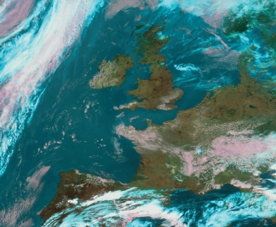
A satellite image of an anticyclone over Britain and western Europe. This weather phenomenon generally brings fair weather and clear skies.
Where the land meets the sea
Where land and sea are adjacent along coastlines, they heat and cool at appreciably different rates. This causes temperature and air pressure differences across the boundary between the two domains. In summer, when the land heats up rapidly, air moves from the sea to the land. In winter, when the land cools rapidly and the sea has retained its summer heat, the reverse occurs. This means that the distribution of the continents and oceans across the surface of the Earth has a considerable influence on global climate and seasonal climate cycles.
Stationary air masses
In the polar and tropical sectors of the world there are huge, semi-permanent high-pressure systems (anticyclones). These air masses hang about, showing little movement for long periods of time, which means a polar anticyclone is cool and a semi-tropical one is warm.
Air will flow out from these anticyclones in an attempt to reach energy equilibrium across the surface of the Earth. As it moves, it takes up more characteristics from the surfaces underneath.
Moving air masses
As air masses move over sea or land, they are influenced by their origin and the track that they take. Polar air moving southwards in the Northern Hemisphere (and northwards in the Southern Hemisphere) is likely to be cold. Air masses blowing over the sea are probably moist, while those blowing over the land are likely to be dry.
Categorisation of air masses
|
Air mass |
Characteristics |
|
Polar maritime |
Cold and relatively moist |
|
Polar continental |
Cold and dry |
|
Tropical maritime |
Warm and moist |
|
Tropical continental |
Warm and dry |

A typical weather forecast map, showing isobars in black, warm fronts in red and cold fronts in blue. This map shows a large high-pressure system over the Atlantic Ocean.
Weather fronts
Weather fronts can be warm, cold or occluded (stationary). If warm air approaches and replaces cold air a warm front is formed. If cold air approaches and replaces warm air a cold front is formed. Cold fronts move faster than warm fronts, so if the former catches the latter and the warm air is pushed off the ground totally by the cold air, an occluded front is said to have formed. The fronts are not just at ground level but extend high up into the atmosphere.
Cold air is heavier and denser than warm, so as the lighter, warmer air rises above it, it gradually cools, water condenses and clouds are formed. This is why fronts are often associated with rain. On a weather map, a warm front is denoted by a line with red semicircles and a cold front by blue triangles. An occluded front has both. The direction of the semicircles and triangles shows which way the front is moving.
Air pressure
Air is heavy. It pushes down onto the ground and the force with which it does so is called ‘air pressure’. There is a greater volume of air pushing down at sea level than on the top of a mountain so the air pressure at sea level is high, while on a mountaintop it is low.
Highs and lows
An area of low pressure is a mass of rising warm air that expands and cools, but cooler air cannot hold as much moisture as warm air so water vapour condenses and clouds are formed. A low-pressure system is, therefore, often accompanied by rain.
An area of high pressure is a mass of sinking air that warms as it approaches closer to the Earth’s surface. Warm air holds more moisture, so areas of high pressure are often accompanied by good weather. Points of the same pressure are joined by ‘isobars’, and on weather maps these appear as rings around high and low pressure systems.
Air flows directly between high- and low-pressure systems in an attempt to balance out the two pressures. This is how wind is created. Winds tend to blow from high pressure to low pressure, but because of the rotation of the Earth and friction with the surface below, they are diverted around the pressure systems.
In the Northern Hemisphere, winds blow anti-clockwise around a low-pressure system or cyclone and clockwise around a high-pressure system or anticyclone (and the opposite in the Southern Hemisphere). The greater the pressure difference between high and low pressure, the stronger the winds. On a weather map, isobars that are close together indicate strong winds.
![]()
FACT
Water boils at 100°C (212°F) at sea level, but at low pressure it boils at a lower temperature. On top of Mount Everest, ‘boiling’ water reaches a temperature of only 75°C (167°F).
Leisurely pressure
The anticyclone or high-pressure system is slow moving and can almost stop altogether. This is known as a ‘blocking high’, and it can force other weather systems to go round it. They are common over the Baltic Sea and Scandinavia, and sometimes in summer can mean weeks of beautiful, sunny weather. High-pressure systems are not always associated with fair weather, however. In winter, they can cause thick fogs and severe frosts.
Sometimes an area of high pressure is sandwiched between two low-pressure systems. This is known as a ‘ridge’ of high pressure and it often brings settled weather.
High-speed jet streams
Jet streams are narrow rivers of strong horizontal winds, blowing at over 50 knots (93 km/h or 58 mph), which are found above 6,000 m (20,000 feet) in the upper atmosphere. They not only manoeuvre storms but also determine where areas of high and low pressure are located. They form along the upper surfaces of warm and cold air masses.
As their tracks change, meteorologists watch them closely. During especially cold winter weather in the United States, for example, the jet stream can be over the Gulf of Mexico, while in summer it is over Canada.
There are several known jet streams but one of the most notorious is a stream that sometimes forms over Africa. At a height of 3,658–4,572 m (12,000–15,000 feet), it runs underneath the 15,240 m (50,000 feet) high Equatorial jet stream about 7° north of the Equator. Here violent thunderstorms arise that move across the Atlantic and develop into the full-blown hurricanes that devastate the Americas.
There are also ‘jet streaks’ – high-altitude winds that move faster than the surrounding winds, and ‘low-level jets’ – high-speed winds a few hundred metres above the Earth’s surface.
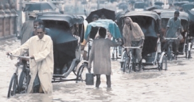
Monsoon
The word ‘monsoon’ comes from the Arabic word mausim, meaning ‘season’. In meteorological terms it is the seasonal reversal in the direction of the wind. It occurs in many countries of the world but the most well known is the Asian monsoon. It requires a large land mass and a vast ocean surface to function, and this it has with Bangladesh, India, Pakistan, Nepal, Sri Lanka, Thailand and Vietnam, the Arabian Sea and the Indian Ocean.
Asian monsoon
In autumn and winter, the Asian mainland temperature decreases, causing the wind to blow away from the land toward low pressure over the sea, creating the ‘north-east monsoon’. In spring and summer the land warms up, causing a low-pressure system to form. With the land reaching temperatures of 45°C (113°F), up to 20°C (38°F) warmer than the sea, the winds then blow from the sea to the land, forming the ‘south-east monsoon’. The south-east monsoon carries huge quantities of rain. This wet phase starts about 25 May when two arms of the monsoon – one through Sri Lanka and the other moving up from the Bay of Bengal – invade the mainland.
In the early 1900s, the Russian-German climatologist Wladimir Peter Köppen introduced the most widely used classification system for world climates. He identified five classes and numerous subdivisions, though his findings can be summarised into three basic groups, with subdivisions corresponding to patterns of vegetation:
Low latitude climates
Close to the Equator – influenced by Equatorial tropical air masses.
Tropical moist climate: Tropical rainforest with heavy rainfall all year, more than 250 cm (100 in), constant temperature of about 27°C (81°F) and humidity 77–88 per cent. Includes the Amazon Basin, Congo Basin and the East Indies from Sumatra to New Guinea.
Wet-dry tropical climates: Savannah with a very wet and a very dry season in India, Indochina, West Africa, southern Africa, parts of South America and northern Australia.
Dry tropical climate: Deserts in latitude 18°–28° in both hemispheres, regions close to the Tropics of Capricorn and Cancer, and occupying 12 per cent of the world’s land surface, including south-west United States, Argentina, North Africa, Botswana, Namibia and central Australia.
World climates and their associated biomes

BIOME: A major regional community of living organisms, such as grassland or desert, characterised by the dominant forms of plant life and the prevailing climate.
Mid-latitude climates
Temperate – influenced by both polar and tropical air masses.
Dry mid-latitude climate: Barren grasslands with little or no trees (‘steppe’), a semi-arid climate, warm summers and cold winters. Any drier and these regions would be desert, any wetter and they would be tall grass prairie; locations include western North America, central Europe and Eurasia.
Mediterranean climate: ‘Chaparral’ vegetaion made up of drought-resistant shrubs and trees, with wet winters and extremely dry summers giving rise to frequent natural fires. Locations include lands bordering Mediterranean Sea, central and southern California, coastal West and South Australia, coastal Chile and tip of South Africa.
Moist continental climate: Deciduous forest in the battlefront between polar and tropical air masses, with abundant rain and snow throughout the year. Locations include eastern United States, southern Canada, northern China, Korea, Japan and central and eastern Europe.
High latitude climates
Polar – where polar and continental air masses meet in the Arctic, but not in the Southern Hemisphere.
Boreal forest climate: Coniferous forests (‘taiga’) with a continental climate of long cold winters and short, cool summers, including northern North America, Eurasia from Europe across Siberia to Pacific.
Tundra climate: Grasses, moss and heath growing in frozen soil (‘tundra’) along Arctic coast areas with a long and severe winter and a short mild season that is not a true summer. Locations include the Arctic regions of North America, Greenland coast and northern Siberia beside the Arctic Ocean.
Highland climate: Alpine cool and cold climate found in mountain and plateau areas, but with the same seasons as the surrounding region. Locations include Rocky Mountains, Andes, Alps, Himalayas, Mount Kilimanjaro in Africa and Mount Fuji in Japan.
The Earth tilts on its axis by 23.45°, and so during the course of the year the Sun’s rays hit the Earth at different angles. Most energy is received when the Earth’s surface is at right angles to the Sun, and this only happens between 23° North and South. Elsewhere it arrives at a shallower angle, the shallowest angles being closest to the Poles. In temperate regions, however, the changing angle gives us our seasons – spring, summer, autumn and winter, when different parts of the world are tilted toward the Sun at different parts of the year.
Solstice
The summer and winter solstices are the days on which the Sun reaches its furthest northern and southern declinations. The winter solstice, the shortest day in the Northern Hemisphere, is 21 or 22 December. The summer solstice, the longest day, occurs on 20 or 21 June. The reverse is true in the Southern Hemisphere.
![]()
FACT
Due to the elliptical shape of its orbit, the Earth is actually closest to the Sun during the northern winter, and furthest away around 3 July. This shows that the angle to the Sun is more important than the distance from the Sun.
Equinox
These are the days when day and night are equal. Two annual equinoxes occur when the Sun passes over the Equator. The vernal equinox occurs on 20 or 21 March, and is the beginning of spring in the Northern Hemisphere and of autumn in the Southern Hemisphere. The autumnal equinox occurs on 22 or 23 September.