Freezing rain consists of supercooled water droplets that freeze on contact with the ground, forming a glaze of slippery ice. Roads are so icy they become impassable, and the build-up of ice on telephone lines and power cables can become so heavy it brings them down.
Freezing rain usually forms as a narrow band of rain on the cold side of a warm front, where warm air is sandwiched between colder air above and below. The air above and ground below has temperatures at or below freezing. The rain begins falling as snow in the upper cold layer, but on leaving the cloud it meets a layer of relatively warm air and melts into conventional rain that continues to fall. The temperature closer to the surface is at or below freezing, but the rain itself does not freeze; it is said to be ‘supercool’. When the supercooled drops hit the ground, power cables, trees or anything in the open, they freeze instantly, forming a thin layer of ice.
Ice storms deposit two types of ice:
Glaze ice: Transparent and homogeneous layers of ice that lie on horizontal and vertical surfaces are known as ‘glaze’.
Rime ice: Milky and crystalline ice, resembling sugar, is ‘rime’. It is less dense, less persistent and causes less damage.
![]()
FACT
Freezing rain is extremely dangerous. People can fall down steps or on pavements, or getting out of their cars, causing serious injury and even paralysis. Automobiles can go totally out of control, with multi-car pileups and fatal traffic accidents on roads like skating rinks.
Ice storm Canada
In January 1998, southern Quebec and New Brunswick in Canada and New England in the United States were hit by five days of the worst ice storm in living memory Some areas received over 120 mm (4.7 inches) of freezing rain, more than double that normally experienced in this region. It hit forests badly, causing widespread die-off of deciduous trees, especially sugarbush from which maple syrup is obtained. It has taken several years to recover. Evergreens stood up better to the extra loading; a 15 m (50 foot) conifer can carry as much as 45,000 kg (99,000 pounds) of ice.
The impact on the local area and people was considerable. Three weeks after the ’98 Ice Storm, 700,000 houses were still without power. About 120,000 km (75,000 miles) of power and telephone cables were brought down, and damage was so severe in southern Quebec that entire sections of the grid had to be rebuilt rather than repaired. Over 100,000 people sought refuge in shelters, and 25 people were killed.
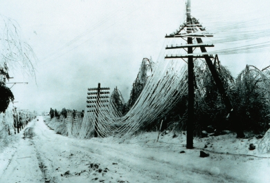
Power and telephone lines sagging under the weight of ice from an ice storm. This effect brings people into dangerous proximity with live electrical currents.
Hail originates in towering convective clouds, such as cumulonimbus, where supercooled water droplets aggregate around dust particles or other hail in the process of forming. The water freezes around the particle, but the particle does not necessarily fall. It can be blown about inside the cloud gathering more water and increasing in size. Therefore, the longer hail remains in the cloud, the bigger it becomes. Eventually, it becomes too big for the air mass to support and it drops. It appears usually as rounded, but sometimes irregular-shaped, pieces of ice. Its structure, if sliced in two, is like an onion with clear and opaque layers. It is classed as ‘hail’ if the diameter of the pieces is more than 5 mm (0.2 inches), each lump known as a hailstone. Smaller pieces are known as ‘ice pellets’, ‘snow pellets’, or ‘graupel’.
Ice pellets
These are pieces of ice less than 5 mm (0.2 inches) in diameter, and arrive in two forms – hard grains of frozen raindrops or melted and refrozen snowflakes, and pellets of snow encased in ice. They bounce when they hit the ground and are more commonly referred to as ‘sleet’.
Snow pellets
Snow pellets are frozen precipitation consisting of small, opaque, white, round or conical grains of ice with a diameter between 2 mm (0.08 inches) and 5 mm (0.2 inches). Unlike hail, they break up when they hit the ground. They are known also as ‘small hail’ or ‘soft hail’.
Graupel
This is frozen precipitation with snowflakes or ice crystals combined with supercooled water and frozen together.
Hail thunderstorm
Hail often accompanies thunderstorms, frequently along a cold front where the air above is much colder than that at the bottom. Updraughts in the thundercloud keep the hail aloft and individual hailstones can grow to an enormous size. Hail can also occur in tropical regions, where severe and supercell thunderstorms have very strong updraughts. Hail can fall, therefore, in summer when there may not be a cold front.
Expensive damage
In recent times, extreme hailstorms have hit several cities with expensive consequences:
11 July 1990: Hailstones the size of cricket balls fell on Denver, Colorado, United States, with an estimated US$625 million worth of damage to roofs and automobiles.
5 May 1995: Dallas and Fort Worth, Texas, United States, spent US$2 billion in repairs following hailstorms.
12 April 1999: Sydney, Australia, experienced AU$190 million of damage and many people were injured.
19 July 2002: 25 people died and hundreds were seriously injured in freak hail conditions in China’s Hennan Province.
![]()
FACT
The worst human and environmental damage from a reported hailstorm occurred at Munich, Germany on 12 July 1984. Entire fields of crops were destroyed, bark was stripped from trees, 70,000 buildings had roofs pockmarked with holes, 250,000 cars were bombarded by ice and 400 people were badly hurt. The bill came to an estimated £6 million.
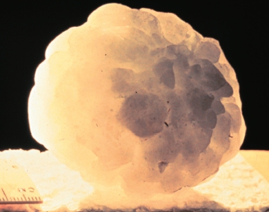
Hailstones are short-lived so accurate measurements are difficult to attain, making record holders impossible to verify. As a result, the world s biggest hailstone has been claimed in several locations.
6 July 1928: In Potter, Nebraska, United States, a record-breaking hailstone fell. It was 17.8 cm (7 inches) in diameter and weighed 0.68 kg (1.5 pounds). This record lasted for over 40 years, before the 1970 Coffeyville hailstone (see below) took its place.
5 September 1958: The largest recorded hailstone in the British Isles landed at Horsham, West Sussex, on 5 September 1958. It weighed 142 g (5 ounces).
3 September 1970: A hailstone fell in Coffeyville, Kansas. It measured 14.5 cm (5.67 inches) in diameter, 44.5 cm (17.5 inches) in circumference and weighed 760 g (1.67 pounds), the heaviest on record in the United States.
14 April 1986: A hailstone reported to weigh 1 kg (2.25 pounds) landed in the Gopalanj district of Bangladesh. According to the Guinness Book of Records (1994), the hailstorm killed at least 92 people and injured many more.
June 22 2003: A hailstone with a diameter of 17.8 cm (7 inches), a circumference of 47.6 cm (18.7 inches), and weighing 0.59 kg (1.3 pounds) landed at Aurora, Nebraska. The quick-thinking local residents who found the hailstone immediately preserved it in a freezer so it could be measured. About 40 per cent of the hailstone was lost when it hit a roof, however, and it had melted somewhat before measurements could be taken, so the actual hailstone was much bigger. Although lighter than the Coffeyville hailstone it is recognised by the National Climate Extremes Committee, the body responsible for validating records, as the biggest hailstone in the United States. It is preserved in the deep freeze at the National Center for Atmospheric Research, Boulder, Colorado.
Hail speed
The speed with which a hailstone falls depends on its size. One researcher came up with the suggestion that the terminal velocity (the speed at which it hits the ground) is ‘roughly proportional to the square root of its diameter’.This means a 1 cm (0.39 inch) hailstone ploughs into the ground at 50 km/h (31 mph).The giant Coffeyville 144 mm (5.67 inch) hailstone, one of the largest known, is thought to have fallen at a speed of 169 km/h (105 mph).
![]()
FACT
The most notorious region for large hailstones is northern India and Bangladesh, where more hail-related deaths are recorded than anywhere else in the world. China is also known for its killer hail storms.
Hail comes in all shapes and sizes, and since the nineteenth century reports of odd-shaped hailstones have regularly emerged:
22 August 1893: A hailstorm on the Lincolnshire Wolds, England, flattened cereal crops and gardens, smashed glass, beat chickens to death and caused a horse to bolt and a dog to be killed. The hailstones were not smooth and round but irregular shapes with sharp spikes of ice sticking out, like stars.
10 August 1898: Prince William County, Virginia, United States, was the location for another strange hailstorm. The hailstones were flat plates of ice, up to 51 mm (2 inches) long and 19 mm (0.75 inches) thick. Similar hailstones fell in Portland, Oregon, in 1894.
7 April 1962: The SS Afghanistan was at anchor off Umm Said, Qatar, when it was hit by hail the size of tennis balls. Some hailstones were even bigger, at least 127 mm (5 inches) in diameter. The sea was a ‘mass of white foam’ caused by splashes from the hail, and the ship’s brass covers for its compasses were badly dented.
This Boeing 737 was struck by heavy hail during a commercial flight over Europe.
Turtle hail
On the afternoon of Friday 11 May 1894, a hailstorm at Bovina, 13 km (8 miles) east of Vicksburg, Mississippi, delivered a hailstone complete with an 20-cm (8-inch) long gopher turtle inside! It must have been sucked up by a waterspout.
Exploding hail
On 11 November 1911, large hailstones, each about 25 mm (1 inch) long and weighing 225 g (8 ounces), came down in a hailstorm in Virginia, United States, and exploded when they hit the ground like popping popcorn. The sound was so loud it could have been mistaken for breaking windowpanes or pistol shots.
Floating hail
A hailstorm at Baghdad and Hinaida, Iraq, on 24 April 1930 was unusual in that the hailstones almost ‘floated’ to the ground. They were over 25 mm (1 inch) in diameter and would have been expected to hit the ground at more than 48 km/h (30 mph),but their descent was timed against the wall of a building and found to be little more than 15 km/h (9 mph), indicating an upward current of air of at least 48 km/h (30 mph) blowing unusually close to the ground.
A letter in Scientific American (1882) described how a gang of railway workers near Salina, Kansas, ran for their lives when hailstones weighing up to 2.3 kg (5 pounds) came raining down. One piece they picked up was estimated to be 36 kg (80 pounds). It was placed in sawdust to stop it melting, and by evening it was 74 cm (29 inches) long, 41 cm (16 inches) wide and 50 mm (2 inches) thick. There was also a cigar-shaped hailstone over 30 cm (1 foot) long and 10 cm (4 inches) in diameter.
Ice blocks from the sky
Large hailstones are one thing, but throughout history there have been reports of large blocks of ice dropping mysteriously from the sky. Theories put forward to explain this phenomenon include ice falling from the wings of airplanes, violent or unusual weather patterns or small comets (which are made of ice and dust) entering the Earth’s atmosphere and striking the ground, but no one explanation has yet been proved to be correct.
Late 1700s: Reports came out of India describing a block of ice ‘as big as an elephant’ dropping from the sky and taking three days to melt.
December 1950: A man driving to Dumbarton, Scotland was almost struck by a rain of ice blocks. The police collected and weighed the fragments and they totalled 50 kg (112 pounds).
1951: A carpenter, working on a roof in Kempton, Germany, was killed by a 1.8-m (6-foot) long shaft of ice.
1957: A farmer in Bernville, Pennsylvania, United States was narrowly missed not by one but by two spheres of ice, one weighing about 23 kg (50 pounds).
1965: The roof of the Phillips Petroleum Plant in Woods Cross, Utah, United States, was punctured by a 23-kg (50-pound) block of ice.
1973: The best-documented icefall occurred in Manchester, England. British meteorologist R. E Griffiths was waiting at a street corner when a huge chunk of ice fell from the sky and smashed into the road just 3 m (10 feet) from where he was standing. The largest piece he recovered weighed 1.6 kg (3 pounds).
January 16 2000: Reports emerged from Spain of large blocks of ice, about the size of basketballs, dropping from clear skies. Aircraft waste was eliminated as an explanation as the ice was clear and consisted of pure water.
Snow is a form of precipitation consisting not of water droplets but of individually formed ice crystals. It is created when water vapour condenses high in the atmosphere, where the air temperature is below freezing at 0°C (32°F).
Ice nuclei
Snow differs from rain in that the properties of particles acting as ice nuclei are very precise. Sea salt, for example, fails to make good ice nuclei, whereas clays, such as kaolinite and illite, do. About 85 per cent of ice crystals analysed in Greenland have a clay particle at their centre. Decomposing leaf matter is also good for ice nuclei.
Snow crystal types
All snow crystals have six-sided symmetry. It is often said that no two snowflakes are alike, but this, of course, would be impossible to verify. Basic shapes include:
Capped column: Resembles a cotton reel
Stellar: Star-like with six sides but unstable
Plate: Flat hexagonal plate
Column: Resembling a Greek or Gothic column or bullet-shaped
Needle: Miniature bamboo sticks associated with heavy snowfalls
![]()
FACT
While the Chinese were intrigued by the shape of snow crystals as early as 200 BCE, it was not until 1611, that German astronomer Johannes Kepler (1571–1630) published what is thought to be the first scientific description of snow crystals in a pamphlet called On the Six-Cornered Snowflake.
![]()
FACT
If snowflakes fall at a rate of 3.6–6.4 km/h (2–4 mph), it could take about an hour for one to fall from a cloud to the ground.
World snow
There is less chance of snow falling at or near sea level at latitudes close to the Equator, the delineation generally accepted as 35° North and 40° South. Even in the bitterly cold Polar Regions, very little snow falls each year because at polar temperatures the air mass loses its ability to hold water vapour. Ironically, permanent snow can be present at or near the Equator, for the higher the altitude the greater the prospect of snow. Therefore, snow is present on East Africa’s Mount Kilimanjaro, for example, but the only snow actually on the Equator is at 4,690 m (15,390 feet) on the southern slopes of Volcán Cayambe in the Andes of Ecuador, South America.
Throughout the world, 65 countries have snowfalls at sea level to 1,000 m (3,280 feet), and a further 35 have snow at higher altitudes.
Giant snow drift
The greatest accumulation of snow during a winter season occurred on Mount Baker, Washington State. During the winter of 1998–99, 28.96 m (1,140 feet) of snow piled up on its slopes. The previous record had been held by Mount Rainier, also in Washington State, with 28.5 m (93.5 feet) of snow in the winter of 1971–72.
Snow terms
Blizzard: A storm with high winds and a heavy fall of snow.
Bluffart: Scottish name for a sharp squall with a short snowfall.
Flurries: Periods of light snowfall that tend not to settle on the ground.
Ground blizzard: Strong winds drive fallen snow into drifts and whiteouts.
Packing snow: Snow near melting point that is great for snowball fights and building snowmen.
Slush: Snow that is melting into puddles with ice floating in them.
Snizzle: Frozen drizzle, a light fall of very small snowflakes or ice particles.
Snow squall: A short but intense storm with a heavy fall of snow.
Snowstorm: A storm that lasts for a long time accompanied by heavy snowfall.
Siberian Express
The ‘Siberian Express’ or ‘Alberta Clipper’ is an extremely cold flow of air that originates in Siberia, moves across to Alaska and northern Canada before heading south into the United States.
Blizzards
A snowstorm becomes a blizzard when the winds blow at 56 km/h (35 mph) or more, air temperature drops to -7°C (19°F) or below, and falling snow restricts visibility to 150 m (500 feet) or less. In the United States, blizzards are common in the northern Great Plains states. South Dakota, for example, is sometimes known as the ‘blizzard state’.
Great white hurricane
The ‘Blizzard of 1888’ was the worst in American history. It occurred between 11 and 14 March, bringing the east coast from Chesapeake Bay to Maine to an abrupt halt. Major cities, such as New York, Boston, Philadelphia and Washington, DC lost contact with the outside world when telegraph and telephone cables were brought down. Emergency services were put out of action and over 400 people died.
The storm was preceded by several days of unusually mild weather, but rain turned to heavy snow when the air temperature plummeted. During the next 36 hours, 127 cm (50 inches) of snow was dumped on the states of Massachusetts and Connecticut and 102 cm (40 inches) buried New York and New Jersey. Winds piled the snow into drifts 12–15 m (40–50 feet) high.
Black snow
On 30 January 1897, black snow fell on Eskdalemuir, Scotland. The surface of unbroken snow was blackened to a depth of 6 mm (0.25 inches), yet the snow below was the usual white. A 6.4-km (4-mile) stretch of countryside was blanketed in the black snow, although it was not even. The cause of the black snow was probably soot from a nearby manufacturing town.

A college hiking group struggles through blizzard conditions on Mt Washington, New Hampshire, United States.
Giant snowflakes
From time to time in recent history, there are records of snowflakes of exceptional size. On 7 January 1887, for example, snowflakes up to 100 mm (4 inches) in diameter and 40 mm (1.6 inches) thick fell at Chepstow, England. The large flakes were composed of hundreds of undamaged crystals joined together. Even larger flakes fell at Fort Keogh, Montana, United States, on 28 January in the same year. They measured 38 cm (15 inches) across by 20 cm (8 inches) thick.
Antarctic in the United States
The weather around Mount Washington in the state of New Hampshire, United States is sometimes as harsh as that of the Antarctic. Wind chills have been reported to drop the temperature to -84°C (-119°F), and the strongest wind speed ever recorded on the planet – a speed of 372 km/h (231 mph) – was experienced here, where the average wind speed is gale force and every third day it is hurricane-force. The annual average air temperature is about -3°C (26.6°F), the lowest measured at -44°C (-47°F). An average of 6.5 m (21.3 feet) of snow falls each year, with maximum falls of up to 14.3 m (47 feet). Buildings near the summit, known as the ‘City in the Clouds’, are often covered with rime ice, resembling ‘sideways icicles’, which forms in the thick fogs that envelop the mountain for 60 per cent of the year.
![]()
FACT
Snow falling from a cloudless sky is a phenomenon sometimes seen in severe cold and calm air conditions in polar regions. The snow can be different shapes, ranging from ice needles to star shapes to flat snowflakes and ice granules without structure. The snow sparkles in the sunlight and has become known by polar explorers as ‘diamond dust’.
Between three million and ten thousand years ago, much of the world was enveloped by ice and snow. This was the time of the last Great Ice Age, which started about 45 million years ago, and which technically we are still experiencing. It was not an era of continuous cold, but long icy periods separated by shorter interludes of almost tropical conditions. Mountain glaciers formed on all the continents, and an ice sheet several thousand feet thick covered parts of North America and Eurasia.
Little Ice Age
This was a period of cooling temperatures recorded from the fourteenth to mid-nineteenth centuries. It included cold spells starting in 1650, 1770 and 1850, separated by warmer intervals. Pack ice moved further south in the Atlantic, with records of Eskimos landing in Scotland. Swiss glaciers advanced, engulfing villages and farms. The River Thames in London, England, and Dutch rivers and canals froze over, and folk there held ‘ice fairs’. New York Harbour froze during the winter of 1780 and people could walk from Manhattan to Staten Island. Iceland was ice-bound and European colonies in Greenland died out. Springs and summers were cold and wet and disrupted agriculture gave rise to widespread food shortages.