
PLATE 1.A small selection of sand, demonstrating its astonishing variety: (from top) quartz sands from Florida, Sumatra, and Algeria, ooliths from Mexico, olivine from Tahiti, forams from Bali, and volcanic glass sand from the Galapagos. (Sands courtesy of Peter Newman; photo by author)
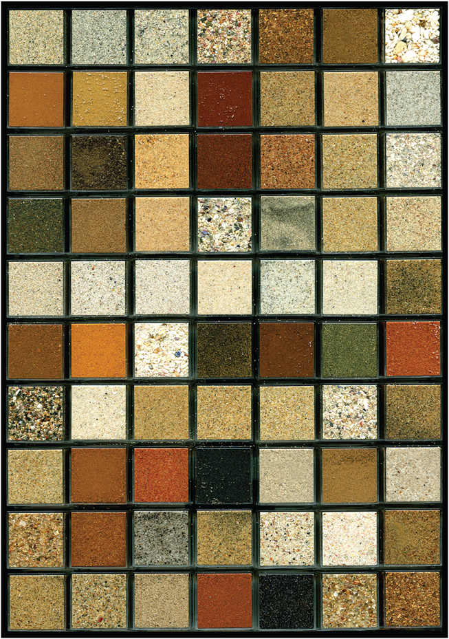
PLATE 2.Sands of South Africa, arranged and photographed by Loes Modderman. (Photo courtesy of Loes Modderman)

PLATE 3.The ingredients of beach sands: Isle of Wight (left), Provence (right). (Photos by author)

PLATE 4.A microscopic view of oolith grains from Mexico (inset). Ooliths make up much of the sand in the shoals of the shallow tropical waters of the Bahama Banks, seen in the satellite photo at right. The puffy “floating” objects in this image are clouds. (Inset photo by author; Bahama Banks image by NASA/GSFC/METI/ERSDAC/JAROS and U.S./Japan ASTER Science Team)

PLATE 5.During the Loma Prieta earthquake of October 17, 1989, in California, sand volcanoes, or “boils,” erupted in the median of Interstate 80 west of the San Francisco—Oakland Bay Bridge toll plaza. Ground shaking transformed a loose water-saturated deposit of subsurface sand into a sand-water slurry that vented along a fissure 7 meters (23 ft) long. (Photo by J. C. Tinsley, courtesy of U.S. Geological Survey)

PLATE 6.A satellite view of the northeastern United States, showing the sand grain’s journey down the Susquehanna River to the Chesapeake Bay—and perhaps beyond, to the Outer Banks. Note the plumes of sediment in the estuaries and around the Outer Banks. Locations referred to in chapters 4 and 5 are labeled. (Image by NASA)

PLATE 7.Continental and oceanic topography: the deepest regions are dark blue, the highest are red. During periods of low sea level, the light blue areas beyond today’s shorelines would have been dry land. (Image by NOAA, National Geophysical Data Center)

PLATE 8.Two sand dwellers: a ghost crab playing with sand, and a trumpet worm inside its shell. (Ghost crab courtesy of Robert J. Amoruso, www.wildscapeimages.com; trumpet worm courtesy of Kåre Telnes, www.seawater.no)

PLATE 9.Mountains, dunes, salt flats, and (sometimes struggling) vegetation of the Namib Desert. (Photo by author)

PLATE 10.A “street” of clear ground between dunes in the Western Desert of Egypt. (Photo by author)

PLATE 11.Viewed from space, colonies of horn-shaped barchan dunes migrate southward (toward the right of the image) in the Egyptian desert; note the “babies” and the barchanoid ridges of coalescing dunes. In the bottom photo, one of the roads highlighted in the satellite image is being covered by an advancing barchan, the avalanching lee face moving toward the bottom left. (Top image by TerraMetrics; bottom photo by author)

PLATE 12.Seif dunes of Egypt’s Great Sand Sea, generally moving southward toward the bottom of the satellite image. The most active ridges are the pale lines on top of the broad foundations of sand, seen as sharp crests in the view from the ground (bottom). (Top image by TerraMetrics; bottom photo by author)

PLATE 13.Towering thicknesses of the Devonian Old Red Sandstone in Sofia Sound, East Greenland. (Photo courtesy of Peter Friend)

PLATE 14.Making a Vajrabhairava sand mandala. (Photo courtesy of the Huntington Archive, the Ohio State University, John C. and Susan L. Huntington)

PLATE 15.Examples of the sand art of Andrew Clemens. (Photo courtesy of the State Historical Society of Iowa, Des Moines)

PLATE 16.Burns Cliff, Endurance Crater, Mars, November 2004, recorded by the hardworking Opportunity. (Image by NASA/JPL/Cornell)

PLATE 17.Desert treasures. (Photo by author)