4
Societies on the Move
A Journey to the Sea
The river knows its way to the sea;
Without a pilot it runs and falls,
Blessing all lands with its charity.
ORIGINS
In the time that it took you to read the epigraph above, trillions of sand grains around the world moved, taking another step on their endless journey. The Earth’s business is change, ceaseless movement and recycling, a kinetic system where everything is in constant motion, be it continents plodding along at the rate a fingernail grows, or landslides and earthquakes changing our world in an instant. Sand is a principal actor in this dynamic and never-ending performance, by virtue of its size born to be transported by gravity, rivers, waves, ocean currents, and winds, shape-shifting into ever-changing landscapes. The science of geology is entirely about change. Changes with time, climate, latitude, altitude, temperature, pressure, velocity, depth, size—these are the voices in the stories the geologist seeks to read and to tell.
When I reflect on the things that lured me to geology as a child, apart from family holidays on the crumbling and fossil-strewn coasts of England, two books are clearly important. The first, out of print and not generally regarded as a classic, is The Earth’s Crust: A New Approach to Physical Geography and Geology by L. Dudley Stamp. Published in 1951, it was called “a new approach” because Stamp had commissioned huge models of different landscapes—and what lay beneath them. The book included photographs of the models, which had been constructed in exquisite detail by Tom Bayley, a lecturer in sculpture.
For me, the book was magic. I was captivated by the models. I studied them intently and even tried, messily, to make some myself. They opened my eyes to how landscapes and their foundations work. I could look around me on those summer holidays with a different understanding—I could visualize things. And, best of all, some of the models depicted change—for example, the appearance of a glaciated valley when it was still filled with ice and after it had melted (illuminating for family excursions in the ice-sculpted landscapes of Wales and Scotland). My curiosity about the world around me was aroused; I was alerted to geology, to the processes of the Earth’s surface.
It is these processes, constantly performed by rivers and oceans and wind, and involving mass migrations of societies of sand grains, that we will look at in the next three chapters. But first, the second book. This is a classic, and I was its proud owner, at the age of six, in Minneapolis. It was only as an adult that I realized its importance to me in terms of revealing the world and of setting the scene for the journeys of geology. It was Paddle-to-the-Sea, and it will resonate particularly with North American readers of a certain age. Holling Clancy Holling was a Michigan-born writer and illustrator of children’s books, by far the most acclaimed and loved being the story of the journey of an Indian boy’s small wooden carving of a canoe and its occupant. Paddle-to-the-Sea was first published in 1941 and reprinted many times.
In the hills above the Canadian shores of Lake Superior, the boy carves the canoe to take the journeys that he cannot, and on the bottom he inscribes the words “Please put me back in water—I am Paddle to the Sea.” Setting the carving on a snowbank in spring, he watches the meltwaters carry Paddle down into the streams that flow into Lake Superior, the start of a meandering four-year journey to the sea. Paddle’s adventures through the Great Lakes to the Gulf of St. Lawrence and the Grand Banks are not only a gripping narrative, exquisitely illustrated, but later the reader realizes how much he or she learned along the way. And Paddle’s journey, as the canoe is swept around by currents and waves, marooned for long periods on beaches and sandbanks—and by human activities—before traveling on, is an allegory for the movement of sand.
Whenever our family car would break down en route to our vacation destination, my father would cheerfully declare that “it is better to travel hopefully than to arrive.” While as a child I was never fully convinced of this, the statement (paraphrasing Robert Louis Stevenson) does evoke the nature of journeys, human and granular. In this chapter, we will take a river journey with a sand grain, a journey driven primarily by natural forces but also one that, for the great majority of the world’s rivers, inevitably encounters human influence. Rivers are highways for sand and humans, and interaction is as unavoidable for the sand grain as it was for Paddle.
BEGINNING THE JOURNEY
Pick up a single sand grain at the beach and you have encountered it in the midst of a potentially endless journey over vast distances and immense lengths of time. It has been swept around the surface of the Earth by rivers, waves, and the wind. It has been buried, compacted, soldered together with its companions into solid sandstone, melted, uplifted, battered, and swept away again, pausing, perhaps, to be excavated, mined, or quarried. The sand grain’s tale is like that of a soldier—long periods of boredom punctuated by brief episodes of brutal activity. Except that the long periods are truly long, and the episodes are often on an immense scale.
In chapter 1, we saw the birth of an individual sand grain, liberated from solid granite by the relentless attack of weathering. Falling onto the slope beneath its parent rock, nudged or swept downhill by rain and torrents, the sand grain joins countless traveling companions under gravity’s rule. Most sand grains on Earth have taken a journey down a river at least once in their lives, and perhaps hundreds or thousands of times.
Think, for example, of a sand grain born, for at least the second time in its life, in one of the most remote and spectacular places on Earth, the Canaima National Park in southeastern Venezuela, near the borders of Guyana and Brazil. It has been resting for some hundreds of millions of years in a sandstone that is one of the oldest in the world. Two billion years ago, great rivers flowed across this part of what we now call South America, meandering, flooding, constantly changing their routes, just as the Amazon and the Orinoco do today. And, as rivers always have, they carried with them huge cargoes of sand, traveling hopefully, born from the disintegrating rocks of ancient mountains long since subdued and flattened.
These ancient South American rivers flowed, as most rivers do, over the continent to an ocean. But this early version of South America looked very different than it does today; small ancient fragments of continent had only recently been welded together to form the kernel of what would become today’s continent. Close to a couple of billion years would pass before the Andes were plastered along its western edge. The ocean to which the rivers flowed has long since been swallowed up and obliterated by the voracious churning of the Earth’s plates, today’s Atlantic being only a distant, indirect descendant.
As the rivers slowed on approaching the sea, as floods abated each year and channels changed their course, the rivers lost the energy to carry their cargo of sand and dumped it in sandbars, estuaries, deltas, beaches, and offshore banks. This process continued, year after year, over millions of years, and these abandoned layers of sand eventually covered a vast area of the fledgling continent. As the rivers roamed over the landscape, the layers built up in places to an enormous thickness, their foundation sinking to accommodate the load. Buried under this great pile, the sands were compacted and solidified into hard, rocky sandstone.
Much, much later, the continent, buffeted by colliding plates along its edges, was heaved upward again. The sandstones were back at the Earth’s surface and began their battle with the elements, a campaign that they continue to wage today, hundreds of millions of years later; these two-billion-year-old sandstones form the extraordinary landscapes of the Canaima National Park. Vertical cliffs a kilometer or more high protect vast flat-topped plateaus that look out over hundreds of kilometers of forest and savannah. The layers of sandstone once covered these areas, but they lost the battle with the elements and were stripped away. The mountains are the resistant remnants and have probably looked very much the way they do today for more than three million years (Figure 18).
Incredibly, in spite of all the geological violence going on around them—the split from Africa, the opening of the Atlantic, the rise of the Andes, and the splintering of the Caribbean—these sandstone layers remain essentially as they were deposited two billion years ago, not tilted but horizontal. It is this that creates the great flat-topped peaks, dissected and isolated by erosion around them, but toweringly intact. Sir Arthur Conan Doyle set his story The Lost World on these virtually inaccessible plateaus (tepuis, table mountains, in the local Pemon language), imagining them with dinosaurs and sandbanks “spotted with uncouth crawling forms, huge turtles, strange saurians, and one great flat creature like a writhing, palpitating mat of black greasy leather, which flopped its way slowly to the lake.” The true ecology of these plateaus is only somewhat less incredible. Long isolated from larger communities, many of the amphibians and reptiles that live here are found nowhere else in the world, including blind black frogs a couple of centimeters long. Nine hundred species of higher plants have been identified on one mountain alone, of which 10 percent are endemic. Thirty species of birds are unique to the area, and the task of describing the character and diversity of the insect life will continue to occupy entomologists for a long time. Many of the mist-shrouded summits in the park, which was awarded World Heritage status in 1994, remain completely unexplored.

FIGURE 18. The table mountains of the Canaima National Park. (Photo from Stewart McPherson, Lost Worlds, McDonald and Woodward Publishing Company)
So, a grain of sand, torn from its mother rock and mountain roots more than two billion years ago, carried along by ancient rivers, dumped in a sandbar, buried under a great thickness of more sand, heated and squeezed together with its companions, and elevated a couple of thousand meters above sea level, has resided there ever since. The climate on the plateaus of the tepuis is extreme: an average of 2.5 meters (8 ft) of rain fall each year and temperatures range from freezing to 30°C (90°F). The torrential volumes of rainwater form pools, bogs, and streams, and the plants, many of them carnivorous, combine with these to concoct a mildly acid brew. The constant warming and cooling, the chemical effects of the waters, the root systems of the plants, and the general extremes of a tropical climate conspire to attack the integrity of even the oldest and hardest sandstones. As a result of this incessant weathering, the rocks are sculpted and worn into monoliths, towers, sinkholes, gullies, and canyons, within which water constantly pools and overflows.
The sand grain, which last saw individual freedom two billion years ago, is finally liberated by the incessant onslaught of climate and chemistry and carried by the rain to a small pool. During a particularly heavy downpour, the pool fills and overflows, and the sand grain is washed out. Tumbling down a gully in the torrent, it is unceremoniously swept over the edge of the plateau in a plummeting waterfall; the drop is a kilometer (3,000 ft) or more over Angel Falls. The falls are named not in recognition of their apparent origin in the mists of the firmament, but after Jimmie Angel, a flamboyant bush pilot seeking gold in the footsteps of the conquistadors and Sir Walter Raleigh. This region of Venezuela is one of the reported locations for the mythical city of El Dorado, and there certainly is gold there, but Jimmie Angel never found it. On one of his trips in 1933 he did, however, see a huge waterfall, cascading “from the sky”; flying to its top and base, Jimmie accurately estimated its height. Angel Falls is the highest free-falling waterfall in the world, and much of the water evaporates by the time it reaches the bottom. But it carries our sand grain—together with its companions—on its new journey of freedom.
The grain of sand, having hurtled off the plateau, finds itself in one of the streams feeding into the Rio Caroni. The Caroni has risen farther to the south in the Canaima and flows northward, joined later by the Paragua, and onward toward the Orinoco and so out to the Atlantic. All the water raining on an area of mountains, forest, and savannah larger than Scotland finds its way into the Caroni, and the flow of the river in flood is as much as 10,000 cubic meters (350,000 cu ft) per second—close to the average flow of the Mississippi at New Orleans. In a massive movement of water like this, even when the river is not in flood, the sand grain has virtually no chance to rest. The turbulent water picks it up, carries it along, drops it, and picks it up again, swirling and hurtling onward. The total volume of sand and mud transported in this way by the river is huge: 52 million tons every year, on average. To put it another way, if you were to stand by the river for a day, 5,700 large dump trucks full of sand and mud would drive past. And this isn’t even the Orinoco, never mind the Amazon.
The Caroni would seem to be a perfect example of a wild river, a case study for the natural processes of a river transporting sediment. But, sadly, it is not. Our sand grain’s journey, which began so well, so dramatically, is doomed.
Within 150 kilometers (100 mi) of the start of its journey, instead of continuing its tumultuous travels down the riverbed, the sand is dumped, suddenly and unnaturally, into an enormous lake. This is Lake Guri, at an area of 4,300 square kilometers (1,700 sq mi) one of the world’s ten largest reservoirs. Fifty years ago, it didn’t exist. The lake is formed by the Guri Dam, the second (soon to be the third) largest hydroelectric generating plant on the planet, and it is the end of the road for our sand grain. The grain will remain trapped in the lake behind the dam, buried along with millions of tons of its fellow travelers. The massive water flow in the Caroni is causing the river’s demise: there are three further dams on the river below Lake Guri, and three more are planned above it.
But the consequences of stopping a sand grain on its journey are huge. The effects of dams, not only in the Orinoco system, but anywhere in the world, include major modifications to the delivery of sediment to the river system downstream and to the ocean; this, in turn, alters entire landscapes. Changing with the seasons, a river system left to its own devices irrigates and drains, excavates and backfills the terrain through which it flows. Disturb that delicate but massive balance by disrupting water flow and impounding sediment, and you change landscapes and ecosystems. Louisiana loses over 30 square kilometers (12 sq mi) of critical wetlands every year as a result of the reduction in sediment carried by the Mississippi and the effects of levees and canals. This is the land that should not only maintain biodiversity but also, critically, act as a natural defense against hurricanes. Such changes, however, will be dwarfed by those stemming from the Three Gorges project on the Yangtze River above Shanghai. The reservoir there will be 600 kilometers (370 mi) long when it is full and a very effective sediment trap. The amount of sediment coming downstream has more than halved since the dam’s completion, and the delicate balance between sediment deposition and removal at the mouth of the river has been destroyed. The city of Shanghai, built on sandbars that emerged only in the thirteenth century, depends on this balance to maintain its defenses against the sea. In the United States, large dams have been built at a rate equivalent to one a day since the signing of the Declaration of Independence. Today, increasing effort is being put into removing them.
ARTERIES
The world’s rivers are the arteries of sand transport across the continents. Rivers, fluvial systems, are immensely complex and varied and responsible for delivering huge quantities of material to the coasts and all other sedimentary systems. They occur everywhere, in every climatic zone, on every scale, and in every kind of terrain—and this has been true throughout the Earth’s history since the first rains fell. Among their hydraulic complexities is the way in which they transport sediment—hence Albert Einstein’s warning to his son (see chapter 1). Ralph Bagnold’s pioneering work, after he had moved on from wind transport problems, took matters back to first principles; he defined, in the language of physics, the power of a river, and observed that it can be viewed as an engine, doing work, transferring energy from the fluid to the grain. And the world’s rivers are, indeed, magnificent engines.
Although human interference through dams and other activities is increasingly disruptive, if the Earth were left alone, on the order of 8 cubic kilometers (10.5 billion cu yd) of the material of the continents would be swept away by rivers into the oceans every year—that’s half a billion dump truck loads. By some estimates, around a third of this natural volume is prevented from reaching the oceans as a result of being trapped behind dams and other man-made obstructions. Nevertheless, the continents are still being constantly ground down, dissolved, cleaned off. Every thousand years, the Himalayas are reduced in height by 30 centimeters (12 in), and the area drained by the Mississippi is lowered by 10 centimeters (4 in). These rates may seem small, but the process never stops. James Hutton, one of the founders of geology, declared in his Theory of the Earth (1785): “The surface of the land is made by nature to decay. . . . Our fertile plains are formed from the ruins of the mountains.”
The Caroni is one of the world’s large rivers—but it is dwarfed by, among others, the Yellow and Yangzte, the Ganges and the Brahmaputra. The size of a river is a matter of what you measure—length, drainage area, sediment transport. It is that last yardstick that we are interested in here. Many factors of terrain and climate contribute to this measure, and it is the most difficult to calculate. For the engine operates in three different ways to carry its sediment load: by rolling and bouncing grains, pebbles, and boulders along its bed, by swirling smaller grains into almost continual suspension, and by carrying soluble minerals dissolved in the water. The last, the dissolved load, is simple to measure, the suspended load relatively simple, and the bed load extremely difficult. Measures of the sediment load of rivers commonly are for the suspended load only, but the bed load is huge. And all of these numbers are only averages—a river in flood will carry orders of magnitude more sediment than it does on a normal day.
To understand some of these processes, we can sometimes turn a river into a laboratory for experiments on a grand scale. In 1963, the Glen Canyon Dam was built 150 kilometers (100 mi) upstream from the Grand Canyon. It did what dams do well and trapped more than 90 percent of the sediment carried down the river, with the result that the canyon was starved of sand. The clear water below the dam had a significantly increased capacity for sediment transport and swept away old sandbanks, reducing habitat for flora and fauna, not to mention tourists. Species of fish that had relied on the protection of murky, sediment-filled water vanished, and others were left vulnerable. Experiments were designed and carried out to release vast volumes of water and sediment from the dam, which would flush out further sand and silt that had become marooned in side canyons, rebuilding the natural sandbanks. The first experiment, in 1996, was overeager—the flow of water was so great that all the sediment was flushed, unimpeded, 450 kilometers (280 mi) down the canyon to Lake Mead.
The second, more controlled experiment, in 2004, was monitored in every way imaginable by the experts. Some scientists traveled by boat along with the peak flow, measuring how the sediment content of the water changed as it surged down-river. One researcher from the U.S. Geological Survey described it as “like riding a bus and keeping track of how many people are getting on and off, but we keep track of how many sand grains stay in that packet of water” (O’Driscoll, 2004). While this experiment was more successful than the first, its benefits were limited, in part because only modest amounts of sediment were available. By March 2008, the volume of accumulated sediment was three times that in 2004 and the experiment was repeated. The taps were opened by the interior secretary, who declared, “the water will be released at a rate that would fill the Empire State Building within twenty minutes,” and “it will transport enough sediment to cover a football field one hundred feet deep with silt and sand” (Environmental News Service, 2008). Analyzing the results will take years, and the durability of any positive results remains uncertain.
Not only floods, but also other unusual natural events dramatically change a river’s burden. Earthquakes frequently trigger landslides, vastly increasing the amount of sediment cascading into, and carried away by, the area’s rivers. The eruption of Mount St. Helens quadrupled the amount of sediment carried by the Columbia River, and the river’s navigation channel was reduced to a third of its pre-eruption depth. In the years following the eruption, nearly 110 million cubic meters (140 million cu yd) of sediment were removed from the main river channels by the U.S. Army Corps of Engineers.
Rivers are naturally complex and highly variable. Our imprint simply adds to the complexity in, as we have seen, a far from modest way. To follow a sand grain on an unimpeded natural journey is not easy—even if the journey begins, like Paddle’s, in a wilderness area. As a consequence of the Aswan Dam, the Nile Delta now receives virtually no sediment at all, and Mediterranean waves and currents are reducing its size daily. Close to 80 percent of the water discharge of the largest river systems in the Northern Hemisphere is affected by human interference. Unaffected rivers lie almost exclusively in the Arctic. Along with water discharge goes sediment transport, and the consequences of our interference, planned or not, are often dire. But it’s not all bad news for sand: reservoirs fill up, and the natural flow of sediment, after a long time, resumes. Major floods can scour reservoir sediment and flush it through the dam system. The Mississippi still ranks in the world’s top ten of suspended-sediment deliverers, in spite of the dams and other human interference along its course.
So, where shall we go to follow the almost unimpeded river journeys of societies of sand grains? To a river that winds its way through dramatic landscapes but is far from wild, a river via which a sand grain has a good chance of reaching the sea to continue its travels. To the “long winding river,” the “long reach river,” or the “great island river,” depending on which Native American language you choose: the Susquehanna. A sand grain’s journey down the river follows the path of Jack Brubaker’s book Down the Susquehanna to the Chesapeake, a compelling biography of a river.
JOURNEYS DOWN THE LONG, WINDING RIVER
Twenty thousand years ago, the northeastern United States was covered in ice. The temperature had plunged during the last of the series of glacial periods, and massive ice sheets had invaded, grinding their way unopposed from the north. They had sucked up volumes of the planet’s water, and sea level was over 100 meters (300 ft) lower than it is today. Setting out from where Atlantic City would eventually be, you would have had over 150 kilometers (100 mi) to walk before you reached the shore. And the ice, grinding and scouring, had brought with it an unimaginably huge cargo of debris, gouged out from the lands to the north. The ice sheets moved southwestward, creating havoc as they went. The Susquehanna River had been carving out its sinuous valley for a long time before this and previous incursions of ice. Where the valley paralleled the direction of ice movement, it was scoured out, but in sections where it was perpendicular, the glaciers simply overrode the intervening hills and filled the valley with debris. Whole regions were dammed by debris, and ice and lakes formed behind the dams.
When the climate warmed and the ice began to retreat, around nineteen thousand years ago, the situation only got worse. As if pursuing a strategy of leaving chaos in the wake of their retreat, the ice sheets dumped every boulder, clay particle, and sand grain that had been trapped within them, disfiguring the landscape. As the ice withdrew, the waters dammed in lakes were liberated, and huge floods hurtled down the valleys. The rate at which the ice retreated, nearly 2 kilometers (over a mile) roughly every fifty years, was so rapid that the land had no chance to adjust. Up until thirteen thousand years ago, an ice dam in the upper reaches of the Hudson River valley had held back a lake three times the size of today’s Lake Ontario; but the dam collapsed, and the lake level dropped rapidly by 120 meters (400 ft). The flood was catastrophic, carrying car-sized boulders past Manhattan and beyond the (then distant) shoreline. The sudden huge input of freshwater into the Atlantic was sufficient to change the climate. Out of this chaos farther south emerged the Susquehanna River of today, patiently reestablishing itself, carving through the glacial debris in its valleys, conspiring with each one of its tributaries to sculpt today’s landscape.
When rain falls in central New York State and nudges a sand grain downslope, the grain’s future journey is determined by the landscapes that the ice sheets left behind. The sand grain could be starting a journey northward to the Mohawk River, then on to the Hudson, and Manhattan; northwestward to Lake Ontario, past Montreal, and out to the Atlantic via the St. Lawrence; or southward into the Susquehanna and a long, leisurely 700-kilometer (440 mi) trip to the Chesapeake Bay and, perhaps, the ocean. Which journey is taken depends on exactly where the raindrop falls, which valleys still remain blocked by glacial rubbish, and which have been opened. Otsego Lake, officially the source of the Susquehanna and a source of wonder to Natty Bumppo in James Fenimore Cooper’s The Deerslayer, breached the glacial dam at its southern end and drains southward, but the great Finger Lakes, not far to the west, remain blocked at their southern ends and drain northward into Lake Ontario. The area within which all water—and all sediment—drains into the Susquehanna covers 70,000 square kilometers (27,500 sq mi) of New York, Pennsylvania (nearly half of the state), and Maryland: this is the largest drainage area of any river on the East Coast (Plate 6).
Our Susquehanna sand grain, plucked by ice from an ancient Canadian terrain and liberated from the glacial sediment in which it had been entombed for ten thousand years, is carried into Otsego Lake, flushed out by a major flood, and carried out into the upper reaches of the Susquehanna. It exits the lake at Cooperstown, New York, home of Fenimore Cooper and baseball.
The river is still today adjusting from the devastation of the ice sheets, eroding away material here, depositing it there; the land itself is still recovering from the burden of ice, rising in some areas, sinking in others, and these are further changes that the river must respond to. The river falls 365 meters (1,200 ft) on its journey from Otsego Lake to the Chesapeake, and if all were stable, its profile, the shape of the curve plotting the topographic elevation of the river bed versus distance from the source, would be smooth and concave upward, its steepness gradually decreasing downstream, toward sea level. The river would be in equilibrium, delivering exactly the same amount of water and sediment that it receives, erosion and deposition in perfect balance. But it is not an ideal world, and the constant adjustments that the river has to make mean that it will be a very long time—if ever—before it achieves stability. In its constant prehistoric battles with ice, sea level, and the ups and downs of the land, the Susquehanna has developed a distinctly peculiar profile. Add to the natural processes man-made changes that liberate more sediment—deforestation, agriculture, and mining, for example—and it is clear that the Susquehanna is a very dynamic river, constantly shifting its course, eroding its banks, and dumping its sediment. This dynamism is complex in the extreme, but there are fundamental principles that we can observe, measure, and replicate.
RIVERS AT WORK
The ways in which rivers operate—or, to use the engine metaphor, literally work—cover a huge range of scales, involving the smallest grain of sediment to the topography of a continent, what happens in a second to changes over millions of years. To begin at the small scale, the world of our sand grain and its companions, we can ask the apparently simple question, “How can we predict whether that grain will be transported or deposited?” The answer is not so simple, but we can define the principles. The sand grain in river water finds itself at the mercy of several different forces. Always there is gravity, urging the grain to fall. Then there is the frictional drag force of the flowing water, urging the grain to accompany it on its downhill journey, but at the same time slowing it down. The grain may be rolled along the bed of the river, or it may be lifted by the same force that lifts an airplane; once plucked from the riverbed, the grain will be carried along by the swirls and eddies of the turbulently flowing water, which accomplishes its work by transferring its energy to the grain.
How far the grain will be carried once it is lifted into the flow depends on a number of factors: grain size, weight, and shape, as well as flow speed. This is where Bagnold’s work—again—comes into play. His definition of particle size according to the rate at which it settles in water is all-important in determining how far a particular grain may be carried. In still water, a coarse sand grain will fall about 10 centimeters (4 in) in a second, but a clay or mud particle will take hundreds of years to fall the same distance. In a river, both will be carried sideways as they fall, moving downstream until gravity causes them to settle back to the riverbed—where the sand will hit other grains and nudge them into movement. The grains move in leaps and bounds, a process called saltation (from the Latin verb saltare, “to jump” or “to dance”). If the grain is small enough and the current fast enough, it will be suspended, along with its muddy colleagues, and travel long distances, potentially for its entire journey.
A river of a given volume of water flowing at a given speed has the capacity to transfer its energy to masses of moving sediment. The capacity to do so increases exponentially with the speed of the river’s flow, in proportion to the cube of the amount by which its velocity exceeds that necessary to start sediment movement. Thus small increases in the velocity can cause the mobilization and transport of large incremental volumes of sediment. But the capacity is not limitless. There is always a constraint to the transporting capacity, and if the capacity drops—if the flow slows—then so do many of the grains, and they are deposited on the bed of the river. The physics of these processes acting on one grain can be worked out, but the scaling up to the flow of billions of grains is beyond computing power—particularly when the interactions between each and every one of them must also be taken into account. Instead, we resort to playing in the sand. We build laboratory-sized rivers, water tanks, and sluices, vary the different factors, and watch what happens—just as we can on a beach.
There is one research facility that takes this idea of playing with sand very seriously indeed. At the St. Anthony Falls Laboratory, on the banks of the Mississippi in Minneapolis, large volumes of water are drawn from the river to be fed into “one of the most expensive sandboxes in the world” (National Center for Earth-Surface Dynamics). This experimental apparatus works on an extraordinary scale: appropriately dubbed “Jurassic tank,” it is half the size of a tennis court and holds two hundred tons of sand. Not only can the overall slope of the tank be varied, but the shape of its floor can be molded into a small-scale version of any natural topography over which water and sediment might flow. The original Jurassic tank has spawned a variety of other specialized experimental apparatuses: the main river model basin is 47 meters (155 ft) long and the depth of a bathtub. Out of these extraordinary constructions have come extraordinary results. Erosion, transport, and deposition of sand can be observed as they happen, and the resulting deposits can be dissected and analyzed in any number of ways to contribute to our understanding of natural-scale systems.
The amount of sediment transported by a river is its load; if the river has the capacity, it will add to the load, scouring and eroding its banks and channel, whereas if its capacity drops, it must dump some of its load. A river’s capacity will vary with shifts in velocity as it follows its own bends or encounters changes in the shape of its bed. As when a cup of coffee is stirred, when river water flows around a bend, it is flung to the outside, its velocity increases, and it carves away at its bank. On the inside of the bend, the velocity and the load-carrying capacity drop and sediment is deposited. The sandbanks that build up on the inside of river bends are termed point bars. They may be swept partially away as capacity rises in a flood, but as the flow subsides they build up again—point bars are long-term features. Each episode of sandbar construction is marked by a new set of layers, with larger grains at the bottom of each layer and smaller grains at the top, reflecting slowing current velocity; the sand is graded (Figure 2).
The sands in point bars tell us important stories, not only of modern rivers, but also of ancient ones. As a point bar grows out into the river, it also encroaches downstream: sand is transported across the submerged part of the bar and tumbles down the downstream slope, which is built out with each flush of sand. As a result of this, the layering of the sand within the bar takes on the angle of that slope; while the bar as a whole may be flat, its internal structure consists of layers that gently slope downstream. The layering of a sediment or sedimentary rock is termed bedding, and it tells us a great deal about the way in which the sediments were deposited. The large-scale bedding in a point bar is flat, but those layers are constructed from individual small-scale sloping beds of sand—cross-bedding (Figure 19). There are many subtly different kinds of cross-bedding, but all result from sediment deposited by a current and give the geologist key information about the direction and strength of the river’s flow—today or hundreds of millions of years ago (chapter 7).
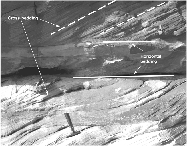
FIGURE 19. Cross-bedding in ancient sandstones. The main bedding is horizontal, but internally the bedding is at an angle, reflecting the underwater slope of the migrating front of a sandbar, moving with the current from right to left. (Note the hammer for scale.) (Photo by author)
GREAT BENDS
No river is perfectly straight for any significant distance, and bends, sometimes wildly sinuous and exaggerated, are the norm. In favoring a winding route, the river is said to meander. This is a highly dynamic process. As it constantly wears away the outside of the bend and deposits sand on the inside, the river channel migrates sideways (Figures 20, 21).
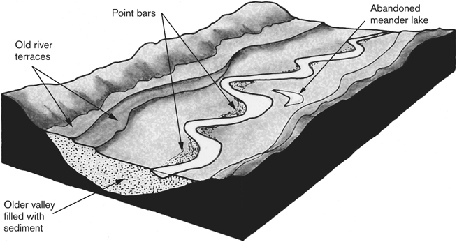
FIGURE 20. Meanders, point bars, and river terraces in a river valley.

FIGURE 21. A river, meandering with point bars. (Photo by author)
As the meanders migrate and exaggerate, they may even cannibalize one another and create an entirely new course for the river, abandoning the old one. Meandering rivers are often accompanied by curving patterns in the surrounding land, remnants of the old channels and point bars, palimpsests of the landscape. The only lateral limits to the migrating channel are the sides of the valley; a typical meandering river will “ricochet” from one side of the valley to the other over thousands of years. A segment of a channel may change its course overnight, shifting its position by hundreds of meters a year. Given that large numbers of people around the world live in the shifting settings of river valleys and that significant economies depend on them, understanding these dynamics is vital. Prior to major human interventions, meanders of the Mississippi were migrating laterally at up to 60 meters (200 ft) every year. Tributaries of the Ganges have shifted 150 kilometers (over 90 mi) in a couple of centuries, and flooded residents of Bangladesh recount how the nearby overflowing river channel was far away when they were children. Shifting sands constantly rearrange the planet—and the lives of its inhabitants.
As our sand grain and its companions roll and skip down the Susquehanna bed or leap up into the river’s flow, they make a brief preliminary foray into northern Pennsylvania and approach the town of Great Bend (Plate 6). The river winds its way through the Endless Mountains of the Allegheny Plateau, rounded hills whose tops mark ancient bedrock protruding from the blanket of glacial debris. The valleys have been deeply cut by the river and its tributaries as they reestablished themselves after being rudely disrupted by the ice. (It is, incidentally, along this stretch of the river that Joseph Smith translated most of the Book of Mormon from the gold plates that were reportedly found buried in the glacial sediments of north-central New York.)
The river is confined to a relatively narrow valley here, but its meanders swing from side to side, eroding glacial sediments and bedrock on the outside of the bends, depositing broad point bars on the inside. Here we see human dependency on the dynamics of river sand: where the Susquehanna takes its great bend northward again, back into New York, the flat land of the resulting point bar has been exploited by both the town of Great Bend and the railroad.
If, as the Susquehanna meanders its way back into New York before finally committing itself to its southward journey through Pennsylvania, you were to stop on any point bar and dig a trench, in the walls you would see the sloping layers of cross-bedded sand. In many places, if you were to rest from your labors and look up, across the river, to where walls of bedrock have been exposed by erosion, you might well see the same structures in the solid rock. If this were to happen, you might be looking at another point bar, one that was constructed in a river that flowed through this area 370 million years ago, when huge river systems flowed westward from the rising terrains of continental collisions to the east (see chapter 7). Our sand grain skips and dances past its ancient relatives, perhaps to be joined by some of them, liberated from the rock by the flowing river.
If the sand grain were to become stuck in the point bar at Great Bend, it most likely would not have the misfortune of being trapped for hundreds of millions of years like its ancient relatives. The chances are good that within a day or a few months, a storm would swell the river and flush it onward. The drainage area of the Susquehanna is so large that it frequently receives huge amounts of water from storms: it is one of the most flood-prone rivers in the country. In June 1972, Hurricane Agnes became a tropical storm and stalled for twenty-four hours over the region, pouring torrential rains into the drainage area. Over 500,000 sandbags were needed around Wilkes-Barre, Pennsylvania, where the water rose nearly 6 meters (19 ft) above flood level. The water flow in the Susquehanna tripled, and more than five million tons (200,000 dump truck loads) of suspended sediment surged past Harrisburg, Pennsylvania, in the space of a few days, several times the average for an entire year. No estimate has been made of the additional bed load hurtling along under this torrent. Stand beside a river in flood and you can hear the bed load in motion, the rumbling and clunking sounds of boulders tumbling along the riverbed. Major floods in 1996 were followed by record flows in early 1998, but a year later water flow was near the record low, less than half the normal rate. It is a dynamic river, the Susquehanna, and at any given time, our sand grain could be hurtling downstream or trapped in a sandbar, waiting for the next, inevitable flood to change the shape of the river.
RESPONSES TO CHANGE
A sand grain journeying down a river is a player in a great game of competing influences, as small as an eddy in an ever-changing channel and as vast as the rise and fall of sea level. The most dramatic shape-shifting that rivers display occurs along the bends. But why do rivers meander? Why not take the shortest, straightest path to the sea? Clearly, the shapes of resistant bedrocks across which the river must flow have a primary influence. If the softer rock formations, the ones that the river can most easily exploit, have a curved shape, then often the river will follow these shapes—but not always, as we shall see farther down the Susquehanna, where it appears to completely ignore the underlying geology. Where there is no bedrock influence, a river will meander regardless—and once formed, meanders are self-perpetuating, constantly exaggerating their shape.
But how do meanders form in the first place? The answer is that we don’t know. We have some basic principles and experimental results, but the physics of fluid flow and sediment behavior is too complex. Even Einstein (presumably before advising his son to avoid the topic) turned his great mind to the formation of meanders, reporting a thought experiment on tea leaves collecting at the bottom of a cup whose contents had been stirred. The flow of water around the slightest bend sets up a complex of internal currents, each reacting with the roughness of the sediment on the base and the walls of the channel, modifying that sediment and, in turn, being modified itself. The smallest change will set off a whole series of essentially unpredictable further changes that feed back into the dynamics of the system. In experiments like those conducted in the Jurassic tank, a perfectly straight channel at the start will soon develop irregularities, which turn into bends, which develop into meanders. Perhaps the movement of a single sand grain is enough to trigger large-scale changes.
It almost seems as if rivers like to meander, to take the leisurely scenic route to the sea. Meanders represent a kind of self-regulating tool for a river. On the face of it, this seems a strange statement: surely a river is just a river, with no underlying game to play? But step back and look at the grand scale. Take a map of a river and run a piece of string along its winding course; then straighten out the string and draw a graph of the river’s elevation versus the distance from its source—the profile of the river. For any river at any given time, there are two points that are externally fixed: sea level and the elevation of the source of the river in the mountains. Between these two points, the river is free to behave in any number of ways. For the river, sea level is the primary base level, its ultimate terminus, below which no part of the river can drop (to avoid the impossible feat of flowing uphill). Base level is a concept universally agreed on and at the same time hotly debated, but the principle is clear: change a river’s base level by raising or dropping sea level, and the river must change its behavior. If base level drops, the river must erode, cutting downward to reflect this. If base level rises, the river must build up its profile by depositing sediment. A change in base level changes the gradient of the river’s profile, requiring the river to make changes in order to smooth out that profile. Changing the geometry of meanders changes the length of the river and therefore its profile, and thus the river responds to changes in base level.
Changes in sea level, then, have far-reaching consequences; as it rises or falls, the effects a re felt not just at the coast, but for a long way upriver. As we consider the consequences of the current rise in sea level, it’s not just the shorelines we need to worry about.
In addition to changes in sea level, natural and human-induced base-level changes also take place locally along a river’s course. Dams, levees, and artificial channels all create feedback into the larger architecture of a river. The river responds to even the slightest change, cutting down or building up, eroding or depositing sediment. Not only is our sand grain at the mercy of storms and floods, and the slow rise and fall of the Earth’s oceans, but it also feels the effects of a world of minute local changes.
THROUGH THE MOUNTAINS
If the flow and capacity of the Susquehanna permit it, our sand grain tumbles past Great Bend, takes a sweeping trip back through New York State, past Binghamton, where recreational beaches used to line the river before the coming of industry and pollution. The sand grain reenters Pennsylvania, tumbling southeastward through meander after meander before turning right toward Wilkes-Barre. The flow of the river—and its sediment load—is ever increasing as it is joined by great tributaries, some of which begin only a short distance from Great Bend but take a more direct route to meet up with the Susquehanna here.
The right turn before Wilkes-Barre reflects a profound change in the continent beneath. Look on any map—satellite (Plate 6), topographical, or geological—and it appears as if a celestial artist has covered the land here in a sinuous, elongated calligraphy. These designs mark a distinctly different setting than that of earlier stages on our sand grain’s journey. Geologists divide up the chapters of the Earth’s past according to the sequence of rocks that tell the story, each one a formation that can be tracked and described and given a local name, and whose surface extent can be drawn on a map. Our sand grain’s imprisoned colleagues back at Great Bend form part of the Catskill Formation, a gigantic pile of river and marine sediment, components of which can be easily examined in the sidewalks and curbstones of New York. (We shall see the Catskill Formation again in chapter 7.)
The mountains that provided the source of the floods of sediment of the Catskill Formation were heaved up in just one episode of the slow movement of continents and digestion of oceans that culminated, nearly 300 million years ago, in the welding of the continents into a single supercontinental entity, Pangea (“all Earth,” in ancient Greek). The titanic collisions that occurred treated the edge of the North American continent like putty, slowly but relentlessly bulldozing the rocks into the great wrinkles and folds (now subdued by erosion) that create the sinuous patterns of our celestial calligrapher’s work. This is the Valley and Ridge Province of the Appalachians, and it is engaged in an ancient battle with the Susquehanna. The collision disinterred almost every kind of rock from almost every period of the continent’s past, resistant rocks forming the ridges, softer and more easily erodable ones the valleys. It is when the Susquehanna encounters the first of these northeast-trending structures that it turns sharply right and enters the Wyoming Valley, treasured by its Iroquois inhabitants and seen by its earliest Western visitors as a quintessentially American paradise. The valley is a geological as well as a topographical depression and is filled with rocks of the Llewellyn Formation, sands, silts, and, sandwiched among them, seams of coal, originally the economic foundation of the region. The Appalachian coals are high-grade anthracite, first used in a blacksmith’s in Wilkes-Barre in 1769. The Susquehanna has provided a highway for the coal industry, allowing boat transport and carving a route for the railway. And it has caused tragedy. The most accessible coal seams are close to the surface, and in January 1959 miners in the Knox Mine, just upstream from Wilkes-Barre, tunneled far beyond the limits of safety, until only a small thickness of fragile rock separated them from the bed of the flooding and ice-filled Susquehanna. With a sound like thunder, twelve billion gallons of water and sediment poured into the mine and twelve miners lost their lives. Mines were closed and the tragedy led to the end of mining in the Wyoming Valley.
CHANNEL BARS
The Knox Mine disaster took place next to Wintermoot Island, a long bank of sand and gravel in the middle of the river. Downstream, other islands break up the main channel, one of them helpfully facilitating a bridge crossing. But what are these islands doing in the middle of the river, where the current should be fastest, sweeping the sediment along? These are channel bars (Figure 22), and their origins are no better understood than meanders. Something in the shape of the channel bed, some small changes in roughness, in frictional forces, in turbulence, splits the current and slows it down, causing the deposition of sand; the process continues and the island grows, emerging above normal water levels and building up downstream. Does the channel bar grow from the ripples and wave forms sculpted into the sandy bed of the river by the current? Or does a split in the water flow result in two coalescing point bars? The internal structure of channel bars, like that of point bars, is similarly characterized by cross-bedding. They can segment the river into so many different channels that its pattern is described as braided.
Channel bars can be large and take up much of the channel, hindering navigation but aiding river crossing and providing habitable space. They are fragile and unstable, however, constantly shifting size and position, steadily marching down the river, disappearing and reappearing during floods and under the attack of ice. Tropical storm Agnes, for example, completely changed many of the Susquehanna’s islands. Historic maps and paintings of the river, compared to its appearance today, graphically illustrate these changes.
One dramatic result of the 1811 New Madrid earthquakes was the appearance and disappearance of channel bars along the Mississippi. But regardless of seismic events, the naturally peripatetic nature of Mississippi sandbars can cause problems—even legal ones. A channel bar was the subject of a long-running boundary dispute between the states of Mississippi and Louisiana. Stack Island is a large, uninhabited channel bar, sometimes above water and at other times not. In the early nineteenth century, it was close to the Mississippi side of the river and the state line ran down the main channel to the west of the island. Time and the mighty Mississippi moved the island across and down the river until the navigable channel lay on its eastern side. Since the law states that, by the “rule of thalweg” (thalweg being another word for a main navigable channel), a state boundary must run along that channel, the State of Mississippi felt that the State of Louisiana had performed a land grab and sought legal retribution. After many years, the case went all the way to the Supreme Court, which came to a final decision in 1995. Louisiana had conceded that in 1881 there had indeed been a Stack Island and that it had belonged to Mississippi, but insisted that “two years later, in 1883, Stack Island washed away and was replaced by mere alluvial deposits, which at various times over the last 100 years were not sufficient in size or stability to be deemed an island.” However, after lengthy geomorphological rumination, the Supreme Court could find no documented or sedimentological evidence for the claimed disappearance, invoked the “island exception to the rule of thalweg,” and allocated Stack Island back to the State of Mississippi (Louisiana v. Mississippi [121ORIG], 516 U.S. 22 [1995]).
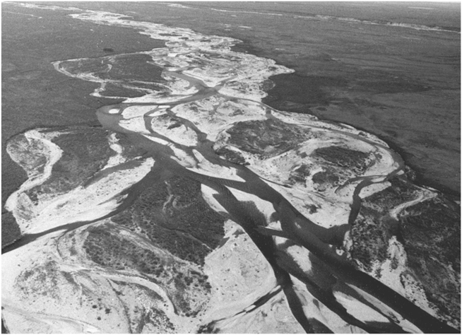
FIGURE 22. A river, braided with channel bars. (Photo by author)
Out of the Wyoming Valley, the river (and, with any luck, our sand grain) makes a sharp left turn and then a right, across into the next valley. Along its way, it dissects an exotic geological lexicon—the Onandaga Formation, the Mauch Chunk, the Wills Creek, and the Tuscarora—traveling past the towns of Shickshinny, Wap-wallopen, and Catawissa. At Sunbury, the river joins forces with a great tributary, the West Branch. The flow increases, the channel widens, and the valley broadens. In the nineteenth century, there was a dam here to permit ferry crossings, but it was destroyed by ice in 1904. However, if our sand grain attempts the passage during the summer today, it faces another impediment—the world’s longest inflatable dam, used to create an area of water for recreational purposes (and which interferes with the local base level). If our sand grain doesn’t make it while the dam is inflated, it will only be a short wait until the air is let out and the winter floods arrive.
AN OLD RIVER
A little farther down, the river faces further challenges from the structure of the Valley and Ridge Province—and overcomes them by doing something very unexpected. Shortly after the confluence with its northwestern tributary, it encounters Mahantango Mountain, one of the great ridges formed from the resistant sandstones of the Mauch Chunk Formation. We might expect the river to be forced to find a way to wind around the end of the ridge to the west, but it doesn’t: it simply carves its way straight through the mountain to form one of the great “water gaps” of the Appalachians. A little farther south and it does the same thing at Peters Mountain—and again at Blue Mountain, just north of Harrisburg. How it has come to do this is, again, the subject of some conjecture and dispute. The mountainous topography that we see today had, for a long period of geologic time, been covered in layers and layers of younger rocks, across which the old Susquehanna had flowed. The river stripped away these rocks and cut down through them, eventually excavating and revealing the old structures of the Appalachians as the topography evolved. Being already established in its course, the river simply kept cutting down, like a knife beginning to slice the filling after penetrating the top crust of a pie. While we have yet to pin down exactly how the river accomplished this remarkable feat, it is clear that the Susquehanna is a very old river. But how old? We do know that, in its games with the comings and goings of ice sheets and changes in sea level, the river eroded far deeper valleys, now filled with sediment, than those we see today; the Susquehanna’s ancestors were certainly carving their valleys and transporting our sand grain’s predecessors a couple of million years ago, or even further in the past.
As it flows past Harrisburg, the river takes on a different appearance. It curves gently, but without meandering, and it is festooned with hundreds of channel bars; point bars develop at some of the gentle curves, particularly where tributaries join. The river is split into so many different channels that it is braided, a sign of large amounts of sediment being transported (Figure 22). The overall channel is very wide, nearly two kilometers (over a mile) at Harrisburg, and the valley floor, while still constrained by the mountains, is in places broad and flat—a floodplain. This is, of course, a very modest floodplain—that of the Mississippi is 200 kilometers (125 mi) wide in places—but the processes are the same. As meanders migrate sideways, carrying successive point bars with them, as channel bars follow that migration, and as the channel floods, pouring out sediment onto the flat land around, so the floodplain is formed (Figure 20). As time passes, the channel migrates back and forth across its floodplain, building it up layer by layer. The floodplain is, in the first instance, ideal for human settlement and transportation—Harrisburg, for example, is built on a floodplain—but it is, by definition, vulnerable to floods. If base level drops, however, then the river cuts down into its floodplain and leaves broad benches, or terraces, of the old floodplain at higher levels, where they are more secure above the new flood level. Alluvial terraces, built of sand and other sediments, have for millennia provided the platforms for human development around the world.
Below Harrisburg, the river passes through another of the great anthracite mining districts of Pennsylvania. A steel mill was built in Harrisburg in 1866 and supplied by local coal. For decades, the coal was broken up and cleaned in the local streams, which, together with debris from mine tips, created a vast input of coal fragments and dust into the river. For decades, this created an industry downstream where Susquehanna sediment was dredged and screened, the sand separated out and the coal taken to Harrisburg for sale. Around 250,000 tons of coal a year were recovered this way, and the channel bars in the river today are full of it—commercial coal dredging has continued into recent times far downstream. Mines were—and are—also the origin of acid waters draining into the river. While little physical change has happened to this part of the river as a result of mining, agriculture, and other human sources, its chemistry can be distinctly unpleasant. Major efforts are underway to change this—the Wyoming Valley watershed and the Susquehanna down to Sunbury have been designated as an American Heritage River.
As our sand grain approaches the Maryland state line, it has more obstacles to overcome in addition to sandbar traps: three dams. But these dams were built in the first half of the last century; two of the reservoirs are now filled with sediment, and one is nearly so. Soon after a dam is built, the deep, empty waters behind it effectively entomb large amounts of sediment. But the accumulation of sand and mud eventually results in shallow water, bringing the bed within the reach of storms and floods. Therefore, if our sand grain does get stuck, it is likely to be rescued by the periodic great floods of the Susquehanna. During the 1996 floods, 15 million tons (600,000 dump truck loads) of sediment were flushed through, and scoured out of, the reservoirs—and so the sand grain has a good chance of making it.
Not far below the dams, the Susquehanna empties abruptly into the Chesapeake Bay. The river provides around 50 percent of all the freshwater entering the bay and, on average, around 1.8 million tons of suspended sediment each year, perhaps 10 percent of which is sand. In addition, the river’s coarser bed load is flushed out into the bay. Once the reservoirs have been filled with sediment, the river’s load will more than double, with consequences that will require some thought and planning. Even today, deforestation, agriculture, mining, and other human disturbances have dramatically increased the rate of sediment transport: when Captain John Smith first explored the lower reaches of the Susquehanna, it was probably transporting half the sediment it does today.
AN ARM EXTENDED IN WELCOME
In The Pioneers, James Fenimore Cooper described the Susquehanna as “a river to which the Atlantic herself has extended an arm in welcome.” That arm, the Chesapeake Bay, has been extending for some time and continues to reach up the river. Eighteen thousand years ago, the Susquehanna would have had much farther to run beyond Havre de Grace, Maryland, its present entry point into the bay. The low sea level during the last of the great glacial advances meant that the shoreline was far to the east, and the channel cut by the ancient river as it worked toward this lowered base level is detectable below the sediments of the bay floor. Sea level—base level—rose with the melting of the ice, and the ocean invaded the bay. The river backed up, depositing its load in response to the dramatic changes. Sea level continues to rise today at the rate of around 4 millimeters (1/6 in) every year, and the river continues to respond.
The Chesapeake Bay is an estuary, a river valley drowned by the sea, and it is the largest in the United States. Because of the effects of glaciation and the resulting changes in the level of the land and the sea, all the rivers of the northeast coast find themselves emptying into estuaries—there is no opportunity to build out into the sea in the way that the great deltas of the Mississippi and other rivers do. Estuaries are the stage for a constant interaction between river and sea, between freshwater and salt water. Twice a day, the tide floods up the bay and ebbs out again, acting like a gigantic pump for water and sediment. Tidal currents set up in the bay are strong, but their effects vary: in some estuaries and at some times of year, the flood tide dominates, at others the ebb, and circulation is complex. Estuaries are dynamic places, but they are also of historic commercial importance the world over. They are, after all, sheltered harbors, which makes them hospitable entrances to the continents and their great rivers. Why did the first exploration of the interior and much of the first settlement of what would become the United States spring out of the Chesapeake Bay?
As Joseph Conrad wrote in The Mirror of the Sea:
The estuaries of rivers appeal strongly to an adventurous imagination. This appeal is not always a charm, for there are estuaries of a particularly dispiriting ugliness: lowlands, mud-flats, or perhaps barren sandhills without beauty of form or amenity of aspect, covered with a shabby and scanty vegetation conveying the impression of poverty and uselessness. Sometimes such an ugliness is merely a repulsive mask. A river whose estuary resembles a breach in a sand rampart may flow through a most fertile country. But all the estuaries of great rivers have their fascination, the attractiveness of an open portal. . . . That road open to enterprise and courage invites the explorer of coasts to new efforts towards the fulfilment of great expectations.
Conrad went on to describe the precautions needed around the sandbanks of the Thames Estuary. Sand grains are the ground troops in the daily battle between river and tide, and they make continuous assaults and retreats, massing again in different places for the next phase of the campaign. The Thames Estuary is strewn with shifting sandbanks whose movements are constantly monitored. One is particularly closely watched. In August 1944, the USS Richard Montgomery arrived in the estuary. She was a Liberty ship, laden with a cargo of bombs for the campaign in Europe, but she never got to unload her cargo as planned: misdirected to her berth, she ran aground on a sandbank, stuck fast, and began to break up. Some of the cargo was salvaged, but the efforts had to be abandoned. The Richard Montgomery remains there today, a literal time bomb. On board still (or buried in the sand around the wreck) are 3,000 tons of munitions, equivalent to 1,400 tons of TNT. If they exploded, it would be one of the biggest non-nuclear blasts in history—and close to population centers, docks, refineries, and gas terminals. The wreck lies in the center of the shipping lanes in the estuary, marked by a buoy and governed by strict rules of avoidance.
The Chesapeake Bay contains no such drama, but it has seen many changes over historical times. About halfway down the bay and close to its center is the Sharp’s Island Light. The structure, which looks like the Leaning Tower of Pisa, is now in 3 meters (10 ft) of water, and there is no Sharp’s Island. In the seventeenth century, there was an island there, originally mapped by John Smith; at 3.5 square kilometers (900 acres) in size, it came to support a thriving farming community. The current lighthouse, built in 1882, is the last of a series designed to warn of the shoals and sandbanks in the area; all succumbed to shifting sands and the destructive power of winter ice floes. The island itself still appeared on charts at the beginning of the last century.
In the Chesapeake Bay, like most estuaries, it is the sea that is winning the sand battle with the rivers—most of the sand in the bay is swept in by wave and tide from the Atlantic and strewn around the estuary. As soon as our sand grain hits the bay, it meets the zone where freshwater and salt water, pumped in by the tides, mix—the EMT, or estuarine maximum turbidity zone. Unfortunately for our sand grain, the EMT is a very effective sediment trap, and much of the Susquehanna’s load is dumped soon after entering the bay. Very little river sand makes it very far into the estuary, but some does. Perhaps during a major flood or storm, a particularly high tide or ferocious currents, our sand grain will be picked up and flushed out into the ocean, to join the trillions of its colleagues already on their coastal journey south toward the Outer Banks. It might even enjoy, like Paddle-to-the-Sea, some human help and make it by boat or in some fishing tackle, or in the sole of someone’s boot. Let’s assume it does.