5
Moving On
Waves, Tides, and Storms
The same regions do not remain always sea or always land, but all change their condition in the course of time.
I with my hammer pounding evermore
The rocky coast, smite Andes into dust,
Strewing my bed, and, in another age,
Rebuild a continent of better men.
A TALE OF TWO LIGHTHOUSES
If you had happened to be enjoying a fine day in late June 1999 by taking a walk along the beaches of Cape Hatteras, on the Outer Banks of North Carolina, you would have thought that your mind was playing tricks. You might have dismissed it as an illusion of some sort and sat on the beach, keeping an eye on your dog and sifting sand grains through your fingers—any one of which might have been our sand grain resting on its journey southward after its escape from the Chesapeake. But the sensation of uneasiness would have remained, and you would have inevitably turned back to look again at the huge, candy-striped lighthouse—and yes, it had moved.
This would not have been a trick or an illusion, a sign of your deteriorating faculties. The Cape Hatteras lighthouse, the highest in the country at over 60 meters (208 ft) tall and a historic icon, was on a slow, 900-meter (2,900 ft) journey from where it had stood for 129 years to a new, safer location. When it was built in 1870, it stood 500 meters (1,500 ft) from the shore. But the same treachery of the ocean that required the lighthouse to warn ships of offshore shoals had threatened the structure itself. By 1935, the waves were crashing only 30 meters (100 ft) from its base. The beach had gone, carried away not just by the regular storms of the Atlantic, but also by daily wear and tear, washed away by the same processes that move the sand between your toes. The cumulative effect of those processes is that Hatteras Island in its entirety is continuously migrating westward.
To move a lighthouse is no trivial task, and many different alternative engineering solutions had been tried over the decades. Since the 1930s, huge lengths of massive steel sheets had been driven into the shoreline to form groins, walls against the sea. The groins were extended and repaired, but time after time storms found their way around them to slam into the defenseless sands and move them on again. In 1966, fourteen thousand dump truck loads of sand were pumped from neighboring Pamlico onto the beach in front of the lighthouse, but the sand was fine, puny stuff, easily dismissed by the waves, and dismiss it they did. In 1973, in a further attempt at what, in the trade, is referred to as beach nourishment, another fifty-nine thousand loads of sand were moved from the cape to the lighthouse defenses, only to be swept away within a few years. By 1980, the sea was once again threatening the lighthouse, and sandbags, rubble, and rubber mats were dropped offshore. None had any lasting effect in the face of the stubborn aggression of the ocean. In 1988, the decision was made to retreat, to move the lighthouse, lock, stock, and lantern, inland. The structure, weighing close to 4,000 tons, was jacked up off its foundation in June 1999 and moved on tracks at around 2 meters (6 ft) per hour over a period of twenty-three days. The lighthouse now stands roughly the same distance from the sea as it did when it was first built. The waves continue their action—as they have, of course, been doing for millennia.
But the forces of nature can be constructive as well as destructive, giving some lighthouses a different problem.
Thirteenth-century France was not what it is today; it was fragmented and torn by conflicts between counts and kings, Spain, Toulouse, and the Holy Roman emperor. Having extended their domains southward through crusades against the peaceable residents of Languedoc, the kings of France needed a Mediterranean port for commerce and further military ambitions. Around 1240, Louis IX decided that an area of lagoons and shifting sandbanks in the Camargue, where the Rhône empties into the Mediterranean, would be ideal. The construction of what would become the extraordinary walled town of Aigues-Mortes began. In medieval times, a tower was generally the way to start a town, and the Grosse Tour du Roi of Aigues-Mortes was completed in 1248.
Although it later earned infamy as an unspeakably cruel prison for Huguenot women, at the time of its construction this tower served a different purpose. In addition to being the anchor of the city’s fortifications, the tower functioned as a lighthouse for the developing port. The port, in turn, was linked inland via canals and rivers to Arles and Montpellier and flourished, rather like France today, through a combination of enterprise and regulation. It also served as the starting point for Louis IX’s ill-fated foreign crusading initiatives.
The king’s luck at selecting the location of a port was no better than that of his military escapades. The Rhône delta is a constantly shifting environment: vast volumes of sand and silt are carried down by the river to the sea, which then takes over the action by shifting everything around. The river moves, the sandbanks move, and the lagoons move, measurably, every year. The port slowly but inexorably filled up with sand, and no amount of medieval dredging could provide a sustainable solution. From the early fourteenth century, the requirement to use this increasingly shallow port was the cause of escalating complaints by shipping merchants. Politics conspired, and when Marseille was acquired by France in 1481, the dominance of Aigues-Mortes was over. The lighthouse that had guided the trade of spices from the East, wool from England, gourmet produce from Champagne, and salt from the local marshes had no further role to play.
Two different lighthouses, two different problems: one, too little sand, the other, too much. The coastal rules of supply and demand of sand operate on a grand scale—and are immensely complicated.
PLAYGROUNDS
Rivers are arteries, gathering and transporting sand to the sea; the coasts and the oceans are sporting arenas for some spectacular events. The players are many and diverse: waves, tides, currents, winds, storms, gravity, topography, geology, history—and humans. For a sand grain entering the game (such as ours from the Susquehanna), the players make the rules: where the grain may go and where it may not, how it will get there, how long it will take, how long it must remain in any one place, and in what sort of company it will travel.
Like a river, an ocean is an engine, conspiring with the atmosphere to do work, often on a grand and awe-inspiring scale. This engine covers around 71 percent of the planet’s surface, and it does much of its work in its game with sand along the coasts. The game is a contest between construction and destruction, deposition and erosion. But the contest is uneven—the waves and currents exert tens of thousands of times more energy than it would take to keep all the sediment along the world’s coasts constantly on the move. The result is that, while the ocean may allow occasional pauses during which new beaches and sandbars are formed (and occasionally preserved for posterity), the waves and currents almost always win in the end.
In order to be able to follow the game, to track, map, and—occasionally successfully—predict the movement of sand around our coasts, we need to understand the arena. Shorelines are transient things, their position depending on sea level at any given time. And sea level itself depends on several different factors. First of all, absolute sea level is a global measure and simply a result of how much water there is in the world’s oceans, that volume depending on how much of the planet’s water is locked up in continental ice sheets and the atmosphere, and on the temperature of the water (the warmer it is, the more volume it occupies). Absolute sea level fluctuates constantly, and in the past, as we have seen during the advances of the ice sheets, it has been dramatically lower than it is today. Relative sea level records the position of the sea at any particular place and reflects not just absolute sea level, but the nature of the land and its intersection with the sea at that point. The land may be rising or subsiding as a result of continental-scale or local movements; sediments may be building up or erosion taking place. Changes in relative sea level affect parts of a particular coast; changes in absolute sea level have worldwide effects. It’s like being in a bathtub—even if the absolute water level stays the same, local water level might be at your chin or your chest, depending on your position.
Globally, absolute sea level is rising slowly. The rate may seem imperceptible, but it has been far from an incidental factor in human history. Our British ancestors made a good life for themselves on the floor of what is now the North Sea; the ice may have made for a cold climate, but it resulted in large areas of habitable land. As the ice melted, that land was so flat that it was inundated rapidly—the North Sea dwellers had to retreat from a shoreline encroaching by meters every year. Today, the Chesapeake Bay continues to invade the Susquehanna Valley, but during the glacial periods, disproportionately large areas of land were exposed, and the ancient Susquehanna had a much longer way to go to reach the sea. But the shorelines as we see them today only reflect the current stage of the contest between land and sea, and bear no relation to the true boundary between continents and oceans.
LANDSCAPES BENEATH THE SEAS
Plate 7 shows the topography of much of the Americas and the western Atlantic with the plug pulled and the ocean emptied. Shorelines as we know them are obvious—but they are not the edges of the continents. The true structural edges, beyond which there is a drop to the deep ocean floor, are often a long way beyond the shore—up to 1,500 kilometers (900 mi) distant. The flooded margins of the continents, covered by relatively shallow seas, are the continental shelves (appearing in light blue), and it is in these arenas that much of the action takes place, where many of the hundreds of millions of dump truck loads of sediment brought down to the coast each year end up. Some of this sediment, as we shall see, escapes to the deep oceans, but, relatively speaking, not much.
During the advances of the ice, absolute sea level was close to the edge of the shelves; the extended journey that the old Susquehanna had to make can be seen from the extent of the continental shelf—above sea level in glacial times—beyond the mouth of the Chesapeake. The apparently precipitous drop to the deep ocean takes place across the continental slopes, in reality not cliffs for most of their extent, but they do represent in total area the steepest topographical zones on the planet. The topography of the oceans is as diverse as, and on a larger scale than, that of the continents, and it is a realm about which daily scientific revelations continue to be made.
It is only relatively recently that we have even begun to understand the complexity of the ocean. On December 21,1872, fourteen years after Charles Darwin had published his revolutionary ideas, a small converted British naval vessel slipped out of Portsmouth, beginning a voyage that would last three and a half years and revolutionize our understanding of the oceans. HMS Challenger (after which the space shuttle was named) had been converted into a research vessel. Her guns had been replaced by laboratories and her munitions stores by over 400 kilometers (250 mi) of rope and wire for surveying and sampling the ocean floor. The voyage covered 130,000 kilometers (80,000 mi) and cost more than $20 million in today’s money. The incentives were many, but two stood out: the needs to plan for global communication via undersea cables and to test the long-standing belief that the deep oceans were lifeless wastes. The latter was dramatically proved wrong, and the former accomplished by large numbers of soundings that first demonstrated the topographical grandeur of the ocean floors. In waters off the Pacific Mariana Islands, a depth was recorded of 8,200 meters (27,000 ft). What became known as the “Challenger Deep” remains the world-record holder today, its greatest known depth later measured at close to 11,000 meters (36,000 ft). Ocean chemistry, temperatures, and huge amounts of other data were collected and, with the publication of the fifty-volume report, oceanography was born. However, it was not until 1957 that the first comprehensive map of the Atlantic Ocean floor, a forerunner of the one shown in Plate 7, became available, providing the underpinning for what would become the ideas of moving continents and plate tectonics.
Today, ever more sophisticated technology allows us to do increasingly detailed imaging of the ocean arena and the activities within it. And while, in many ways, there remain more questions than answers, our understanding of the oceans tells us a great deal about what is happening on the edges of the continents. The Earth’s crust beneath the oceans is geologically young, thin, dense, and, except for a veneer of sediment, composed of igneous rock. The crust beneath the continents is ancient and thick, made up of a huge variety of generally low-density materials. The submarine continental slopes mark the weld between these two very different crustal types; if the Atlantic were removed, the shapes of the Americas and Europe and Africa along the outer edges of the continental shelves, not along their shorelines, would fit together like the pieces of a rough jigsaw puzzle. The continents have been, and are being, moved apart by the daily creation of new oceanic crust, produced by the great ridge of volcanic mountains curving down the center of the Atlantic (the Mid-Atlantic Ridge, identified in our map by its paler blue coloring and rugged topography). The continents are moving apart with little disturbance, except for slow subsidence along their edges as they move away from the deep-seated molten upwelling at the mid-ocean ridge. This subsidence allows the accumulation of thick blankets of sediment on the continental shelves.
The shelves and coasts on either side of the Atlantic are distinct from those where the Earth is less quiet. On the west side of South America, the shelf is narrow and bordered by a deep trench, similar to the one the Challenger found. Here, to accommodate the westward movement of the continent, the oceanic crust and its substrate are foundering into the Earth’s molten interior: as the Atlantic grows, the Pacific shrinks. That process, marked by trenches in the ocean floor, is subduction. The result, demonstrated by the “ring of fire” that encircles the Pacific Ocean, is crustal turbulence on a grand scale: earthquakes and volcanoes, rapid uplift and subsidence. Coasts and shelves along the edges of continents where subduction is taking place differ greatly from their passive equivalents along the Atlantic. Most coastlines in the world fall into one of these two categories, but some, such as California’s, are developed where plates are lurching sideways, past each other, creating the fabled diversity of California’s shores.
Such are the global forces that influence the rules of the game for the sand on the edges of continents. Other forces, as we will see, are more local. The rule book is large. As every grain of sand is unique, so is every segment of coast.
WELL-STOCKED SHELVES: SUPPLY AND DEMAND
Sand is being supplied continuously to the continental shelf, and waves, tides, and currents are constantly demanding more recruits to move around. Our sand grain finds itself in an army of its companions that is constantly being mobilized southward along the Atlantic coast. The next battlefield is the long chain of islands—barrier islands—that form the Outer Banks of North Carolina. Much of the Atlantic coast of the United States is fringed by barrier islands, but this stretch is nearly continuous—and very famous. Called barrier islands for obvious reasons, they shelter the coast behind them, protecting estuaries and lagoons, breaking the power of the ocean storms. But in doing so, they are at the mercy of those forces themselves, and they are fragile; as a result, they are constantly, sometimes catastrophically, on the move.
As any sailor knows, making charts of a coast is a necessary but ultimately thankless task, one that has to be repeated almost as soon as it’s completed. Nature abhors being tied down and demonstrates this nowhere as emphatically as along a coast, and a barrier island coast in particular. We have more than sufficient history to see changes in the charts, as was the case with Sharp’s Island in the Chesapeake Bay. Providing shelter and access to the interior, the Outer Banks played a role in early settlement and exploration, but one of the reasons why the first English settlement, the “lost colony” of Roanoke Island, remains lost today is that Roanoke Island has moved.
Close to Roanoke Island, the Oregon Inlet provides a key break across the Outer Banks for navigation, but the inlet, and the islands on either side, refuse to stay put (see Plate 6). The U.S. Army Corps of Engineers has been examining for years what strategies are possible—and within its control—for keeping it open, waging a long-standing campaign here and elsewhere in the Outer Banks. In 1828, the Corps was commissioned by Congress to acquire a dredging machine and open up Ocracoke Inlet, farther south from Oregon Inlet and equally fickle. After wearing out several dredges, building various jetties that would be destroyed by storms, and spending $130,000, the Corps gave up in 1837—the sand had won. Our capacity for moving sand and our understanding of how barrier islands work may have improved enormously since then, but long-term solutions are no easier to manage. The underlying problem, which we shall return to, is that we have developed an unnatural desire to live in places that we shouldn’t.
Defeating the Army Corps of Engineers wasn’t the first victory for the sands of Ocracoke. In June 1718, Edward Teach, otherwise known as Blackbeard, pirate and tyrant of the eastern seaboard, had almost outmaneuvered Lieutenant Robert Maynard of the Royal Navy among the shifting shoals off Blackbeard’s sheltered camp on Ocracoke Island. But a sandbar outmaneuvered him, and his ship, the Adventure, stuck fast. A gruesome battle ensued, Blackbeard was decapitated, and legend has it that his headless body swam several times around the ship before disappearing. Earlier that year, Blackbeard had, some say intentionally, run his flagship, the Queen Anne’s Revenge, aground a little farther south, in Beaufort Inlet. The storms of 1996 partially scoured a wreck from the sand, claimed to be the pirate’s flagship.
Barrier islands require a substantial and ongoing supply of sand. For the Outer Banks, this is no problem, for the same glaciers that brought our sand grain to the headwaters of the Susquehanna abandoned, in their retreat, huge quantities of their cargo of sediment on the continental shelf—at that time above sea level. As the sea rose and the shelf was inundated, the encroaching ocean had piles of sand and gravel, clay and boulders, to play with. Rivers bring down further sediment each day, but it is still the glacial refuse that provides most of the grist to the mill of the Atlantic coast today. But why was the sand sculpted into this extraordinary string of islands, with the distinctive “elbows” at Cape Hatteras and Cape Lookout? Yet again, we don’t have the complete answer—the islands move at a faster rate than our understanding of them, and their origin has been the subject of intense debate and different schools of thought for more than a hundred years. Some may have formed through the growth of offshore sandbars, the bars interfering with wave and current movements and thus causing more sand to be deposited until the bars rose above water level. But what specified the initial sandbar location? Others may have formed by the elongation of spits of sand streaming downcurrent from headlands. It seems quite likely that the Outer Banks resulted from the westward-encroaching ocean reworking old beaches and sand dune systems from the ice ages—the islands are certainly still migrating westward.
The east coast of the United States and the Gulf of Mexico contain the longest barrier island systems in the world. Less than 15 percent of the coasts of the world sport barrier islands, and the Atlantic coast has 23 percent of them. They behave in very distinctive ways, responding dramatically to waves, tides, and storms. Every wave that hits a beach is shifting tons of sand. If the waves strike the beach straight on, the sand is shifted up—and down—the beach, but if the waves strike at an angle to the shore, then sand is transported along the beach with every wave. This “longshore drift” is characteristic of most beaches, including those of the Outer Banks, where sand is marched southward down the shore. Where there is a break in the island chain, such as at Oregon Inlet, the net effect is that the shoreline to the north of the inlet grows southward and that on the southern side retreats through erosion. This effect is complicated by the tides: flood tides transport sediment through the inlet from the sea, and ebb tides have the reverse effect, building out deltas with each flush of sediment. The net result is the highly complex, large-scale, and seasonally changing movement of sand around the inlet—and a challenge for the Army Corps of Engineers.
Natural breaks in barrier islands not only move, but also appear and disappear almost instantly. The islands respond to storms with dramatic and rapid change. In September 2004, Hurricane Ivan generated the most extreme storm waves ever measured, more than 27 meters (90 ft) in height, devastating the Caribbean. The hurricane then slammed into the U.S. Gulf Coast, causing widespread death and destruction. Figure 23 shows “before” and “after” photographs of the state park at Gulf Shores, Alabama. Roads and parking lots have completely disappeared under blankets of sand, the fishing pier has been fragmented, dunes have been destroyed, and a new break in the barrier island has formed.
Barrier islands vary in form depending on the local balance of waves, tides, and sediment supply, but they typically share some basic features. The beach—the reason these islands are so popular for high-risk residence—faces the ocean, generally backed by a system of coastal sand dunes, some stabilized by vegetation, some actively on the move. The beaches and dunes are where most of the work of the ocean is expended, and behind the islands the natural energy is low (except during hurricanes). Marshes, tidal flats, and lagoons are home to an important variety of flora and fauna sheltered from the ocean. During major storms, however, this tranquil environment is threatened. Sand is torn from the beach and poured inland, covering the marshes and tidal flats and being dumped into the lagoon; the unrelenting force of water and sand carries destruction in its path.
The residents of islands in the Gulf of Mexico know this only too well. During Hurricane Ivan, much of the beach along Dauphin Island, off the coast of Alabama, was transported across the island, reducing its size and changing its shape. After Hurricane Katrina, in 2005, the beach was stripped and spread completely over the island as sheets of sand, known, unsurprisingly, as washover fans. Houses and entire streets disappeared.
Processes such as these result in barrier islands migrating wholesale toward the mainland—unless they are inhibited by our attempts at preservation, in which case they completely change their natural behavior. That behavior responds to the laws of supply and demand and operates on a budget. As with any budget, there are inputs and outlays: sand is added and removed. If there is a surplus, sand is deposited; if there is a deficit, erosion and land loss prevail. Understanding the sediment budget for a given location on the coast is key to defining both natural processes and the consequences of human interference, the budget measuring input of sediment versus removal, directions of transport, and volumes and variations with time of year. Sediment budgets for the world’s beaches are particularly important, given their exposure and the concentration of human activity along them. Certainly, since the Romans, the beach holiday has been an institution—Cicero, Pliny, Tiberius, Pompey, and countless other intellectuals and emperors repaired to the beach for relaxation.

FIGURE 23. Aerial photographs of a section of the Alabama coast before and after Hurricane Ivan in 2004 (the ocean is in the foreground). The arrows mark the same points; note the buried parking lot. The barrier island has been breached and a new channel has broken through to connect the ocean with the lagoon (not visible in these photos). (Photos courtesy of USGS)
In September 1900, two brothers, bicycle mechanics from Ohio, arrived at a beach on the Outer Banks just up the coast from Oregon Inlet. They had come not for a holiday, but because the beach offered constant strong winds and long reaches of flat sand. They set to work not far from a small, desolate fishing village, an outpost named Kitty Hawk. Sand was both the key and the challenge, as Orville Wright remarked in a letter to his sister: “But the sand! The sand is the greatest thing in Kitty Hawk, and soon will be the only thing. . . . The sea has washed and the wind blown millions and millions of tons of sand up in heaps along the coast, completely covering houses and forest.” The Wright brothers suffered setbacks from moving sand, but the wind blew, the gliders took off from the dunes of Kill Devil Hills, and on December 17, 1903, the world changed with the advent of manned, powered flight, takeoff and landing assisted by sand. The memorial to the Wright brothers on a Kill Devil dune has to be firmly shored up to remain in place.
AN ENDLESS DANCE
In their cultural history The Beach: The History of Paradise on Earth, Lena Lenček and Gideon Bosker provide a lyrical but geologically accurate description of their subject:
The beach is not so much a distinct place as it is a set of relations among four elements: earth, water, wind, and sun. Partnered in an endless dance, these elements produce a staggering range of beaches, each subject to constant change, sometimes rhythmical and cyclical, sometimes linear and catastrophic. If there is a single invariant played out on the boundary of land and sea, it is contained in the paradox of ceaseless metamorphoses, in the idea of immutable mutability. Minute by minute, hour by hour, each of the four constituents submits to the action of the others, and each, in turn, bends the others to its influence.
Where earth, water, and wind perform together, when the shape of the coast, the slope of the seabed, the supply of sand, the direction of the waves, and the strength of the tides work in just the right way, a beach is formed. Although the details of this process can cause any one of a wide range of beach types to form, and although there are details that we have yet to understand, there are some basic rules.
First, waves. Generated by friction between moving wind and the surface of the water, waves out in the ocean can vary significantly in size, both in wavelength (the distance between crests) and height. A wave is simply a moving form on the surface of the ocean—the water beneath the crest is rotating in the direction of wave movement, the water in the trough in the opposite direction. There is no net movement of water, only of the form of the surface. At increasing depth below each wave, the amount of water circulation decreases, until, at the depth of the wave base, there is no effect of the wave passing. Wave base is at a depth of half the wavelength, and so large waves have a much deeper influence. In the open ocean, there are waves with wavelengths of up to 600 meters (2,000 ft), and as these monsters roll in across the continental shelf, whose depth is typically less than 200 meters (650 ft), the entire seabed is affected. But smaller wavelengths are more common, and it is only when one of these waves reaches shallow water that it begins its dance with the sea floor. As the wave enters shallow water, there is less and less room for the movement of water beneath, and so the mass of water builds up vertically, forcing wholesale displacement of the water in the direction of the wave’s travel; the wave shovels up sand from the bottom, begins to break, and crashes onto the beach (Figure 24). Thousands of tons of sand may be carried in by the wave, and thousands more moved as it breaks. Add in the effects of the tides, the direction of the breaking waves, the shape of the coastline, and the time of year, and sand is moved up the beach, down the beach, or along the beach. In such a dynamic setting, at any given time there can be net accumulation or erosion.

FIGURE 24. Breaking waves and a typical beach profile.
The slope and topography of the sea floor beneath the incoming waves have a strong effect on beach activity. Where the slope is steep, the wave heaves up, but the water at the base outruns the crest and the whole mass surges onto the foreshore. On shallower slopes, the crest may spill into the trough in front, or—creating the “tube” sought by surfers—rear up into a crest as the trough retreats, crashing down, trapping air beneath it, and hurtling up the beach. Waves conspire with tides to create currents along the shore or, if the space is constrained, rip currents that move rapidly out to sea, the only direction in which the mass of water can go.
The shape and character of a beach will typically change dramatically between winter and summer. In summer, the foreshore slope is gentler, the waves are less steep, and net sand movement is onshore. In winter, more violent wave action steepens the slope and the beach is eroded, with the sand being transported offshore to accumulate in offshore bars. Winter storms will throw up a steep bank of coarse-grained debris at the back of the beach, the berm, which remains beyond the reach of waves during the summer. The mapmakers really should start all over again at least twice a year.
Beaches come and go naturally, either seasonally or over longer periods. The gloriously named Five-Finger Strand in Donegal, northwestern Ireland, has long been a local attraction but a frustratingly fleeting one—every once in a while it disappears for a few years, leaving an unattractive expanse of pebbles. Its most recent disappearance was, predictably, marked by local demands for action, but, fortunately, researchers at the University of Ulster were able to scrutinize the ledgers of the sediment budget for the area. They found that the stability of the beach depends on the precise position of a local inlet—when the inlet shifts, there’s a budgetary demand for sand and the beach supplies it. After a few more years, the inlet shifts again, the demand is no longer there, and the offshore accumulation disintegrates, returning sand to the beach. This particular geological prediction—that the sand would return to Five-Finger Strand—was positive and correct. Five-Finger Strand was not an urgent case—no human infrastructure was threatened, just leisure—and it was nature’s own infrastructure that was the problem.
The approach used by the researchers investigating Five-Finger Strand reflects the definition of what are termed littoral cells, compartments of a coast where the sand budget can be defined in terms of three elements—sources, transport, and deposition—and is more or less isolated from what is going on in neighboring cells. Sand eroded from a beach, a headland, or a pile of glacial debris does not simply travel along the coast endlessly—it may be taken out of circulation for a while by being dumped into a washover fan or swept out onto the shelf and, as we shall see, the deep ocean. Shoreline topography, waves, and currents define the extent of a particular littoral cell, which may extend for a hundred kilometers along the coast and contain its own subcells. This concept has proved of particular value in understanding complex coasts such as that of California—and a number of surprising discoveries have highlighted how much we still have to learn.
For example, it had always been assumed that the load carried by California’s rivers was the primary source of sand for its fabled beaches. But researchers at the University of California at San Diego looked carefully at the littoral cell that covers 80 kilometers (50 mi) of coast in the La Jolla area. Using forensic sand-grain studies, combined with detailed imaging of the sea floor, they showed that at least half the beach sand is derived from the erosion of coastal cliffs and promontories. The rivers may periodically flood huge amounts of sand to the coast, but only when it rains—and not only is that an increasingly infrequent occurrence, but dams, desert irrigation, and concrete channels have also profoundly modified natural sediment delivery. Coastal cliff erosion continues year in, year out, but since many of these critical sources are artificially “armored” to preserve their scenic attraction, beaches may be starved of sand supply as a result.
This is hardly a minor result and demonstrates how far from perfect our understanding of coastal sand movement really is. Nevertheless, we continue to plunge ahead with planned or unplanned amendments to sand budgets, creating a spiraling sequence of cause and effect. For example, travel northward from La Jolla to a different cell, the one that extends from San Francisco’s Golden Gate Park down along the coast past Ocean Beach. Golden Gate Park was once an expanse of sand dunes, but it is no longer, and Ocean Beach, once naturally backed by dunes, is now lined with houses. San Francisco Bay is the natural conduit for huge amounts of sediment, but because the buildup interferes with navigation, the bay is dredged and the sediment is dumped offshore. The budget is completely busted. Ocean Beach dunes no longer provide a buffer against which waves can dissipate their energy, so instead the waves erode the beach. The supply of sand from the bay has been vastly reduced, and sediment movements have been changed by the artificial sandbar created by dumping the sediment dredged from the shipping channel. At least sand is no longer mined from the northern end of the beach, as it was (for gold) early in the last century. The solution would seem to be a budgetary enhancement via the creation of a different artificial sandbar, and the Army Corps of Engineers has been dumping several tens of thousands of dump truck loads of dredged sediment in a new location, closer to Ocean Beach. The results are “promising”—parts of the beach are growing, but is this the result of the new sandbar? Only one thing is certain: it’s a whole new budget, and it will be years before we know if it balances or not.
NOURISHMENT
Occasionally, human activities will change the budget in a constructive way. Crinnis Beach, a popular tourist spot in Carlyon Bay, Cornwall, did not exist before the nineteenth century. Mining the china clay formed from the rotting granites inland had been taking place for hundreds of years, and the sedimentary debris from these mines, carried down to the coast by rivers, threatened harbors and estuaries. In the mid-nineteenth century, one of the rivers was diverted into Carlyon Bay, creating a beach where there had not been one before. Now that mining has ceased, the natural budget requires that the beach be removed, much to the concern of the local tourism industry, and remedial efforts are underway.
Beach nourishment is the official term for trying to put the sand back artificially on shrinking beaches. Sand in gigantic quantities is dredged or pumped via monster hoses from offshore and sprayed onto the eroded beach, at a cost of up to $10 million per mile. On the U.S. east coast barrier island chain, from the southern end of Long Island to southern Florida, the equivalent of 23 million dump trucks of sand has been spread over 195 beaches on more than seven hundred separate occasions. Virginia Beach has been “renourished” more than fifty times. A fundamental problem is not simply that this is treating the symptoms rather than effecting a cure, but that the wrong kind of medicine is often used. Beach sand is, after all, the specific local product of local processes, and replacing it with sediment dredged from offshore is replacing it with something else entirely—finer-grained sand, differently sorted sand, or mud. A typical “nourished” beach erodes much faster than a natural one. There are examples where the best sand has correctly been identified as that in tidal inlets—after all, it’s sand that derives from longshore drift along the beach. But remove that sand, and the only thing that is created is another problem—the next beach downstream from the inlet has a reduced supply.
This is a problem the world over. After the beaches in Cancún, Mexico, were removed (again) by Hurricane Wilma in 2005, tourism was devastated. Renourishment cost $19 million, but a year later the beaches had shrunk to less than 20 meters (65 ft) and the waves had cut steep ledges, which detracted significantly from the beach experience. Sandbags, ironically, are now in place. The hotels suffer, but they are a cause of the depletion, having replaced the vegetation that naturally helped hold the sand in place. Hurricanes always have, and always will, remove beaches; waves always have, and always will, erode the coast. Sea level is rising, and much of the world’s coastline is eroding.
As a very small child, I enjoyed family holidays on the beach at Sheringham, a resort on the east coast of England. Engaged in digging holes and building sand castles, I was blissfully unaware of the erosional conflict going on around me. I was equally unaware of the descriptions of Sheringham by one of the nineteenth-century founders of modern geology, Charles Lyell. In 1830, Lyell published Principles of Geology; or, The Modern Changes of the Earth and Its Inhabitants Considered as Illustrative of Geology. This is arguably the most influential book in the history of geology as a science—it ran to eleven editions during Lyell’s lifetime, each substantially extended with new material. The book was carried by Charles Darwin on the Beagle voyages. Indeed, Lyell did for our understanding of the Earth what Darwin was to do for biology, and he certainly understood coastal change:
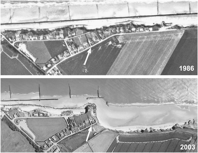
FIGURE 25. Aerial photographs of coastal erosion in eastern England. The arrows mark the same point; note the dramatic recession of the cliffs. (Photos courtesy of Environment Agency of England and Wales and the Coastal Concern Action Group)
The waves constantly undermine the low chalk cliffs, covered with sand and clay, between Weybourne and Sherringham [sic], a certain portion of them being annually removed. . . . Between the years 1824 and 1829, no less than seventeen yards were swept away, and only a small garden was then left between the building and the sea. There was, in 1829, a depth of twenty feet (sufficient to float a frigate) at one point in the harbour of that port, where, only forty-eight years before, there stood a cliff fifty feet high, with houses upon it!
I was digging in the sand before the catastrophic storms of 1953, which claimed over two thousand lives and caused what is benignly referred to as coastal realignment. It continues, day in, day out. Figure 25 shows another set of “before” and “after” aerial photographs, this time of the hapless village of Happisburgh, just up the coast from Sheringham. But they were not taken “before” and “after” a single destructive event; they are simply two frames in the film of ongoing, destructively rapid coastal change. Look at the shore in the two photographs: groins have been built to protect the coast, but they have simply disrupted the natural flow of sand, and the sea has destroyed many of them. “Coastal defenses” simply reorganize the littoral cell and the sediment budget—the problem is either exacerbated, modified, or shifted elsewhere. The sea takes its nourishment from wherever it wishes.
Natural coasts do not need defenses or protection; they change as the rules of the game and the endless dance require. Coastal change has become a problem only since we elected to ignore the prudence of earlier times; civilizations developed along coasts, but with caution. Constrained between the wilderness, the wrathful gods and monsters of the mountains behind, and the visible power of the sea, our ancestors chose to live in the great in-between. We now choose to ignore that experience—and to feel that somehow or other we can do something about the consequences.
BEACH DETAILS
Coastal dynamics are the large-scale movements of the dance, but for a holiday visitor, it’s the details that are most obvious. Any beach is a canvas of patterns and shapes, the swash and backwash of the waves, dark mineral brushstrokes, rivulets, bubbles, pits, and footprints.
Often a beach is not flat, but covered in small ripples, miniature waves in the sand (Figure 26). They may be simple long parallel ridges or sinuous oval shapes. These are bedforms in the sand that result from the interaction between the fluid moving over the grains and the grains themselves—and, yet again, their origin is a matter of some debate. You would have seen similar ripples on the surface of point bars in the Susquehanna, formed by the one-way flow of the river—current ripples, asymmetrical, with steep sides in the direction of current flow. But the ripples on the beach are different—generally much more symmetrical, and often with sharp ridges. In the simplest sense, a wave moving back and forth over the sand transfers its energy to the grains, washes them to and fro, building up small ridges, across which the grains move with the waves. But it’s not that straightforward. For a start, many stretches of beach where the waves move back and forth are flat and unrippled, and why ripples develop in some circumstances and not in others is not entirely clear.
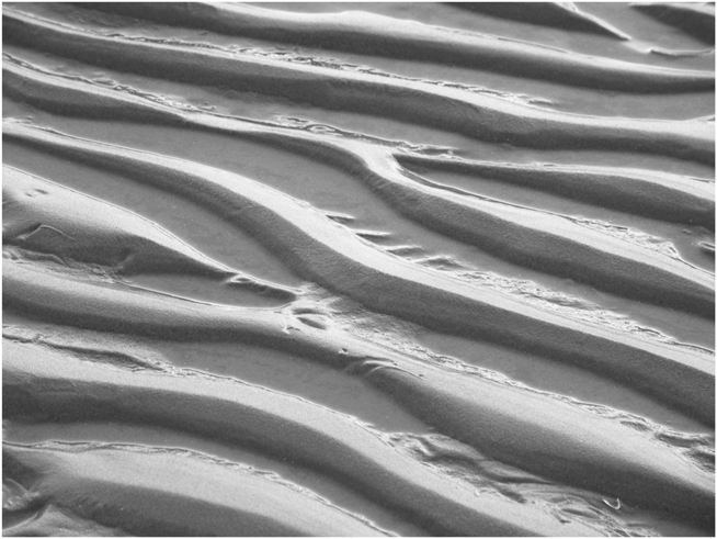
FIGURE 26. Beach ripples. (Photo by author)
George Darwin, son of Charles, was fascinated by ripples and performed a series of experiments using ink in water to define the patterns of turbulence and eddies that move the sand grains. Ralph Bagnold made detailed experiments that reproduced symmetrical ripples and developed relationships between fluid dynamics, ripple size, and grain size. Internally, all ripples show exotic variations of cross-bedding on a small scale, providing clues when such structures are found in ancient rocks. We can describe and name the variety of ripple shapes; we can see that some complex forms result from the combined action of waves and currents. But we don’t really understand them. Larger wavelike forms can develop—water-formed dunes, often with ripples superimposed on their surfaces.
Dark streaks of black sand often serve to emphasize ripples on the beach. As sand grains are repeatedly picked up and dropped by the waves, the heavier grains respond differently than the lighter ones. Grains of iron minerals, heavy for their size, will be the first to be dropped as the wave’s energy diminishes. And so these dark smears are clusters of heavy minerals, and they often are iron—as observed in the eighteenth century by Petrus van Muschenbroek. If the winnowing of the heavy grains is allowed to continue, then over time concentrated deposits of these minerals will form. This has happened in the geological past, and commercially exploitable mineral deposits may result, as we shall see in chapter 9. This also occasionally happens on a modern beach, and such an occurrence was the cause of one of Thomas Edison’s many business failures. On a fishing trip with friends off the coast of Long Island, Edison put into shore for lunch and found the beach covered with a layer of black sand. He took some home and discovered that the black grains were a magnetic iron oxide mineral—magnetite—which stuck to a magnet while the common sand grains fell off. Edison’s enthusiasm ran, as it often did, ahead of his business sense, and he immediately arranged for the purchase of the beach and the manufacture of separating machinery. Unfortunately, by the time he and his colleagues returned to Long Island, a winter storm had reworked the beach and completely removed the black sand.
Every wave breaking on the beach acts as a pump, forcing water through the sand and expelling the air between the grains; when the wave recedes, the water drains out, to be replaced once more with air. This constant intergranular violence makes the tenacity and inventiveness of the meiofaunal residents even more remarkable. Commonly on the beach, you will see large numbers of small holes and some miniature volcanic pits and craters; some holes are made by the residents, but many are the result of the incessant pumping and flushing action of the waves and mark the expulsion of air from the sand. Waves breaking can trap air, making the pumping action more complex and, together with stirred-up organic products, forming the bubbles of sandy foam that sometimes make the beach look like a drained bubble bath. Waves breaking at an angle to the beach will drain back straight down the slope, leaving behind overlapping curving patterns of heavy minerals and debris. A beach is a place of a compelling myriad of patterns and processes, not all of them understood.
RESIDENTS AND GUESTS
Many of the marks and patterns of a beach are, of course, made by the residents—or visitors. Large pits in a beach in Washington State were found to have been left by gray whales excavating the sand at high tide to filter out ghost shrimp buried among the grains; the sand presumably was expelled elsewhere—an unusual means of sediment transport. The shrimp are among several kinds of “ghosts” that may inhabit a beach, rarely seen but clearly evident. Ghost shrimp burrow in the sand below the mid-tide zone to a depth of 2 meters (6 ft). Their burrows, surrounded by small piles of excavated and excreted sand, are evident when the tide goes out. Ghost crabs make complex multichambered residences below the beach or dunes, the entrance hole quite large and surrounded by balls and small piles of sand. Ghost crabs seem to love playing with the sand that they have stripped of food, apparently simply for the fun of it, tossing it about (Plate 8), forming and hurling small balls of it or arranging them into rows. When the crabs emerge from their burrows, their camouflage makes them difficult to see, as does their pace: on hard-packed sand, ghost crabs can move at up to 2 meters (6 ft) per second, a sudden blur of movement. On softer sand, however, they feel the effects of the character of granular materials and slow down markedly.
Holes in the beach can be made by shrimp, crabs, worms, doodlebugs, beetles, snails, shellfish, and a huge variety of other creatures that make their homes among the grains, excavating, building, filtering, and excreting. The microscopic meiofauna of a healthy beach that we saw in chapter 2 provide a richly stocked larder and represent the small-scale end of a long chain of life that tends the beach. Many of these creatures use sand grains to construct their residences, but perhaps the most extraordinary is the trumpet worm, a member of the class Polychaeta, or “many bristles.” The bristles are remarkably strong yet delicate sand-grain movers, both bulldozers and food cleaners, but they are also building tools for the trumpet worm, a master craftsman. From an early age, the worm constructs a protective conical (trumpet-shaped) shell around itself, grain by grain. Each grain is individually selected, examined, and discarded or fitted in place. The process is meticulous, each grain being rotated or repositioned to accomplish a perfect fit, and only then is the glue, secreted from a gland near the worm’s mouth, applied. The structures can be several centimeters (2 to 3 in) long (Plate 8). After the worm dies, the shell can sometimes be found on the beach before it is recycled by the waves.
Not only do the creatures that live under the sand find a ready food supply in their cohabitors, the meiofauna, but their subsurface living also allows them to avoid aboveground predators. The beach is a larder for birds, as described so lyrically by Elizabeth Bishop in her poem “Sandpiper”:
The roaring alongside he takes for granted,
and that every so often the world is bound to shake.
He runs, he runs to the south, finical, awkward,
in a state of controlled panic, a student of Blake.
The beach hisses like fat. On his left, a sheet
of interrupting water comes and goes
and glazes over his dark and brittle feet.
He runs, he runs straight through it, watching his toes.
—Watching, rather, the spaces of sand between them,
where (no detail too small) the Atlantic drains
rapidly backwards and downwards. As he runs,
he stares at the dragging grains.
The world is a mist. And then the world is
minute and vast and clear. The tide
is higher or lower. He couldn’t tell you which.
His beak is focussed; he is preoccupied,
looking for something, something, something.
Poor bird, he is obsessed!
The millions of grains are black, white, tan, and gray,
mixed with quartz grains, rose and amethyst.
SAND SEAS BY THE SEA: DUNES
As at Kitty Hawk and, once upon a time, at California’s Ocean Beach, great ridges of sand dunes often form the backdrop to a beach. Sand is, after all, plentiful, and the wind blows constantly along the coast, reworking the beach into hills of sand. Coastal dunes form a barrier along the coast, buffering the land or water behind by absorbing the energy of storm waves and breaking the force of the wind. They are very different from desert dunes, often less well organized and subject to different forces from different directions. But they are just as mobile as their arid relatives and can be nearly as massive: dunes along Lake Michigan are more than 100 meters (330 ft) high, and those along the Oregon coast extend up to 5 kilometers (3 mi) inland.
Because of their mobility, coastal dune systems are often described as “fragile” environments, but this perspective arises only from the palpable impact of their mobility on human structures—it’s the human structures that are fragile, not the dunes themselves, which are designed by nature to change constantly. Because of the intimate proximity of coastal dunes to human activity and development, conflict is more common than it is with desert dunes, and more dramatic, as noted by Robert Frost in his “Sand Dunes,” where he describes the sea using the dunes to “bury in solid sand / The men she could not drown.” Yet human activity can also create coastal dunes: today’s spectacular dunes at Cape Cod were far less spectacular at the time that the first Europeans arrived, but forest clearing and grazing cattle destroyed soil stability, liberating sand to build the dunes.
We shall look in some detail at the work of the wind and how sand dunes behave in the next chapter, but the principles are simple and follow many of the same rules as for the transport of sand in any medium. As a wind gathers force across a drying beach, it develops sufficient energy to roll, bounce, or pick up sand grains; as the wind loses energy or as the sand grains embed themselves in an already-existing dune, the sand is deposited. But unlike in the desert, water plays a role in the evolution of the dunes. Storm waves erode them, and even in calm conditions rain falls on them, conspiring with salt to form hardened layers that can resist erosion. Vegetation specializing in sandy and salty conditions can capitalize on periods of dune stability and fix the sand even more permanently in place. Many active dune ridges along the beach are backed by vegetated and stabilized ancestors. In some situations, the dunes advance seaward, overriding the beach; in others—barrier islands, for example—they are part of the mass migration landward. On the Oregon coast, forests have been buried as the dunes migrate southward.
Whereas Stephen “Dr. Beach” Leatherman rated Ocracoke, in 2007, as the country’s most beautiful beach, and different stretches of the Brazilian coast have been described as “the world’s best beach,” Daytona Beach, Florida, bills itself as “the world’s most famous beach.” In the 1930s, Daytona Beach was renowned as the setting for a series of land speed records. Wide, sweeping beaches went hand in hand with the extensive dune ramparts that extended the length of Florida’s island coast around Daytona, the two systems existing in a kind of sandy symbiosis. Today, those dunes that have not been bulldozed or built over have largely been eroded as a result of sediment budgetary changes. Where once land speed records were set on a wide beach, the coastal highway is now regularly taken out by storm erosion.
On the opposite coast from Daytona, erosion of the sand dunes protecting the property of the celebrity residents of Malibu Beach has prompted them to bulldoze sand from the public beach to re-create artificial “dunes,” an action greeted, not surprisingly, by considerable public uproar. Elsewhere in the world, moving sand, even with the best of intentions, is also frowned on. The coast of northwestern England, north of Blackpool, is a great stretch of broad beaches and dunes, constantly worked by the stiff breezes of the English seaside. Arthur Bulmer, a pensioner, had enjoyed his modest beachfront home until a week of storms blew seven tons of sand into his garden. The same storms had moved huge quantities of sand into town, building up dunes in car parks and covering local roads. While the local authorities are responsible for clearing the roads, private gardens are the responsibility of the owner; the obvious thing to do, thought Mr. Bulmer, would be to take the sand back to the beach, wheelbarrow by wheelbarrow. This would seem to constitute a fulfillment of civic duty and demonstrate responsibility for environmental restoration. But he was told by the authorities that this would be illegal; it would be an act of fly-tipping, the quaint British term for illegal dumping of refuse. Mr. Bulmer would be liable for the equivalent of a $100,000 fine and up to six months in prison—and have his vehicle, the wheelbarrow, confiscated. His only option was to hire a professional waste disposal company to remove the sand to a waste disposal site.
Arthur Bulmer’s stretch of coast is also known as “England’s Golf Coast,” illustrating a further benefit of preserving back-beach dune ridges. The Old English word for ridges is hlincas, from which the term links is derived, and it was in this terrain that small leather balls stuffed with goose feathers were first whacked about and the revered game of golf—or gouff, or goffe—originated. Many of the world’s finest golf courses, including the Old Course at the Royal and Ancient Golf Club at St. Andrews on the east coast of Scotland, owe their location to coastal dune systems. But nature plays her own game: the seventh and eighth holes of England’s oldest golf course, set in the dunes of the north Devon coast, are about to disappear beneath the waves. On the west coast of Scotland, Alfred Nobel used the coastal dunes around Ardeer as the natural location to construct not golf bunkers, but explosives bunkers, locating his dynamite manufacturing facility there in 1873.
The sheer vastness and beauty of some coastal dune systems is extraordinary. The exquisite photographs of one of the twentieth century’s most influential photographers, Edward Weston, and those of his son Brett celebrate the contours and sculpture of the dunes at Oceano in Southern California. The forms and shadows of the sand are haunting, the grains often seeming to be individually visible, the constant movement caught on film. And the sensual forms of sand are echoed in the nude studies. Unfortunately, a different kind of resonance is now more common: the dunes at Oceano are open today to four-wheel-drive and off-road vehicle recreation.
THREATS AND PLEASURES
Coastal dune systems, because of their close relationships with human occupation, provide compelling images of sand as a threat. On the south coast of Wales, the village of Kenfig was established in the twelfth century as a small port and farming community on a river sheltered by the coastal dunes. It survived the attacks of marauding Welsh tribes, but not the forces of nature, provoked by grazing and the ensuing destabilization of the sand. These factors, probably combined with climate change as the cold period often referred to as “the Little Ice Age” approached, meant that the dunes were on the move. By the fourteenth century, large parts of the town and its fields were covered, and by the middle of the seventeenth century, it was completely abandoned. Hans Christian Andersen’s tragic story Skagen is a tale of death, evil-doing, and unrequited love among settlements and farms overrun by shifting sands (Skagen church remains today half-buried). The story was sung to him “by the storm among the sand dunes.” As Henry David Thoreau wrote in Cape Cod, “The sand is the great enemy here.”
Sand as the enemy is the theme of two stunning, surreal, award-winning films. Woman in the Dunes, the 1964 film by Hiroshi Teshigahara, won the Grand Jury Prize at Cannes and was nominated for two Oscars. Based on the novel by Kobo Abe, it is set in the sweeping wilderness of sand dunes along the Japanese coast at Tottori. An amateur insect collector finds himself abducted and consigned to cohabit with a woman whose crumbling house lies at the bottom of a deep depression in the dunes; she exists “only for the purpose of clearing away the sand.” The sand constantly threatens the house, an outpost on the edge of a village “already corroded by the sand,” whose way of life is defined by fighting the dunes and selling the salt-tainted sand—illegally—to construction companies. In both the book and the film, sand is the enemy but also the central character. The meticulous cinematography and Abe’s writing beautifully document sand grains and their movement: liquid avalanches descending on the house, windblown grains, and the forms of shifting dunes. The book is a lesson in the behaviors of granular materials. And, inevitably, the sand is a powerful metaphor for time: “Monotonous weeks of sand and night had gone by.”
Today, the dunes at Tottori are shrinking due to withdrawals from the local sediment budget, but the 1,000 square kilometers (400 sq mi) of glistening white dunes of Lençóis Maranhenses National Park on the northeast coast of Brazil appear under no such threat. A photograph hanging in a bar on the dune-strewn coast of nearby Ceará was the inspiration for Andrucha Waddington’s The House of Sand, a prize winner at the 2006 Sundance Film Festival. The photograph showed a dilapidated house, once owned by a Brazilian “woman in the dunes” who had spent her life fighting the sand. By the time she died, the house had been destroyed; the sand had won. The film, shot entirely in Lençóis Maranhenses National Park, has four main roles: three generations of women, and the sand. As in Teshigahara’s film, the dunes provide both sweeping landscapes for stunning cinematography and constant microactivity: trickling, avalanching, and flying grains. The House of Sand is a spectacular and haunting illustration of the use of sand as a metaphor for time, isolation, emptiness, and change.
But sand can also be a friend. People love beaches and even create them in the most unnatural places. In 1934, 1,500 tons of sand were dumped onto the mudflats of the Thames below the Tower of London. Intended to provide the only taste of the seaside that many of the city’s poor would experience, Tower Beach was a great success. Even though it could accommodate only around five hundred people and was useable only at low tide, hundreds of thousands of people flocked to it over the following five years, building sand castles, paddling in the water (of dubious quality), relaxing in deck chairs, and enjoying typical beach entertainment. The beach was reopened after the war, but it finally closed in 1971.
The sand below the Tower of London was arguably the first urbeach—a recently coined term to describe beaches constructed in the middle of cities, an increasingly popular habit. Paris has created the Paris Plage along the banks of the Seine every summer since 2002; Berlin, Amsterdam, Rome, New York, and Las Vegas (complete with waves) have followed suit. In the United Kingdom, the most landlocked and urban of cities, Birmingham, is spending $400,000 on two urbeaches, and an indoor beach was a 2007 summer feature of the newly refurbished Millennium Dome.
OUT TO SEA
Armies of sand grains move up and down the coast. They may be trapped en route for a season or for eons, but many are swept by storms, tides, and currents out onto the shelf—and beyond. Tides are not simply the sea rising and falling, but are themselves huge, slowly moving waves. Around the British Isles, this tidal pulse moves clockwise, up around Scotland and down the North Sea. Coastal and seabed topography conspires with this movement to create strong local tidal currents, traveling at speeds of a meter per second (2 mi/hr) or greater, more than sufficient to move huge quantities of sediment. All this complexity and large-scale sloshing around leads to places on the seabed where the net water movement diverges, a “bed load parting.” A sand grain blown into the Seine from the Paris Plage and flushed out into the English Channel (or, since it is a French sand grain, La Manche) could find itself, depending on the time of day and the time of year, traveling out into the Atlantic or up into the North Sea.
Storms and the surges of water that often accompany them supply sand from the coast to shallow marine waters and the engines of tidal currents. The results are vast offshore landscapes of sand: ridges, ribbons, underwater dunes (or sand waves), and bars, constantly on the move. Fields of huge sand waves have recently been discovered covering the floor of the outer reaches of San Francisco Bay; in 100 meters (300 ft) of water, individual wave forms are up to 200 meters (700 ft) long and 10 meters (30 ft) high, moving at 7 meters (23 ft) a year. Huge volumes of sediment (much of which probably originated from human erosional activity during the Gold Rush) have been flushed through the bay, building the field of sand waves. Modern reduction of this supply of sand undoubtedly contributes to the problems we have seen at Ocean Beach. Sand waves are typical of areas where tidal pulses are strong: those in Puget Sound, Washington, are three times the size of the San Francisco examples.
In shallow waters, these bedforms constitute major shipping hazards at high tide but may be exposed at low water. One of the world’s iconic paintings, Théodore Géricault’s The Raft of the Medusa (1818–19), portrays the desperation of survivors of a real event, a shipwreck on a sandbar off the coast of Senegal in 1816. The infamous Goodwin Sands, 16 kilometers (10 mi) of sandbank off the southeast coast of England, have claimed perhaps two thousand ships, been cited as the site of lost communities, are inhabited by countless ghosts and other spiritual manifestations, and, until recently, were the ground for an annual cricket match. The strange English tradition of playing cricket in the sea persists today farther west: sailing for the first time recently into the Solent, the great estuary of Southampton, a Dutch sailor ran aground on Brambles Bank. Seeing a small flotilla approaching, he took them to be intent on his rescue, but instead the passengers disembarked and set up the stumps and a scoreboard for a game of cricket. Such sporting events are, of course, cut short by the tidal pulse.
The continental shelves, and particularly those fed with the seemingly endless supply of glacial debris, are temporary resting places for the majority of marine sands. Sample the seabed anywhere around the British Isles and the chances of bringing up anything other than sand of some sort are small. The same is true of large areas of all the Atlantic continental shelves. Stretching from the Grand Banks of Newfoundland to the shores of New England is a series of massive sandbanks, constantly shifting across the seabed between the coast and the edge of the continental shelf, the ongoing resculpting of glacial debris. Uniquely, and for reasons not entirely clear, these sandbanks emerge above sea level to form Sable Island, 160 kilometers (100 mi) southeast of the nearest mainland. This is one of the world’s most extraordinary—and dangerous—islands. Positioned in the open North Atlantic, subjected to gales, hurricanes, pounding waves, and ferocious winds, and constructed of loose sand without any solid foundation, it seems that it has hardly any right to survive. But survive it does, and it’s a dynamic place.
Sable Island is long and thin, around 40 kilometers (25 mi) from tip to tip (although measurements vary) and just over a kilometer (little more than half a mile) across at its widest point. It lies roughly east-west, its crescent shape looking like a thin-lipped smile in the middle of the ocean. But the smile is deceiving: the island is simply the tip of a vast iceberg of sand, the much, much larger Sable Island Bank. Just beneath the ocean’s surface is a rolling topography of moving sand stretching up to 14 kilometers (9 mi) north to south and perhaps 30 kilometers (19 mi) east to west. The island lies at the meeting point of three major ocean currents, the Labrador current moving southward, the St. Lawrence current moving eastward, and the Gulf Stream on its way north. This interaction causes the waters of the Atlantic to swirl in a great counterclockwise pirouette around the island; but bottom currents, controlled by the tides, swirl clockwise. The result is a complex of ridges and valleys of sand running roughly northeast to southwest. This is a shape-shifting topography, the ridges migrating 50 meters (160 ft) every year, and changing rapidly during the frequent storms. Nautical charts are barely worth the paper they are printed on.
Is the whole island on the move? Opinions differ, and seasonal and longer-term changes in its length and width may create an illusion of wholesale migration. It is located close to the edge of the continental shelf and just south of the Gully, an immense submarine canyon carved down through the edge of the shelf when sea level was low. It seems possible that, over time, large areas of the bank, and perhaps Sable Island itself, will end up as a deluge of sand over the side of the canyon to be swept out onto the deep ocean floor (more on that later).
For the moment, though, the vast shallow sandbanks that surround Sable Island protect it from destruction, breaking the force of the waves in all but the most violent storms. It survives but changes constantly with the seasons and the weather. A hundred years ago, there was a long lagoon sheltered within the sand dunes of the island, but today storm waves have broken through the barrier and the lagoon is essentially filled up with sand. Remarkably, the island’s sand does trap freshwater from the rains of the North Atlantic; cattle were once raised on the island, and a population of feral horses has survived since 1738, eking out a living on the sparse vegetation of the dunes.
The island also has a dramatic human history. Its name is the French word for “sand,” and earlier it was called Isola della Rena, rena being Italian for “sand.” Situated in prolific fishing grounds and on the great circle route from Europe to North America, it has been encountered, not always happily, by generations of sailors, perhaps since the Vikings. It is one of a number of places that claim to be “the graveyard of the Atlantic,” but the island’s claim is well founded. Wrecks, hundreds of them, tragically chart much of the human history of the island. The fogs of the northwestern Atlantic are notorious, as are the storms. Ships have been driven onto the Sable Island Bank or simply sailed straight onto its ever-shifting topography. Some have suggested that the sands contain enough grains of magnetic iron minerals to throw off ships’ compasses; there are indeed magnetic grains concentrated in parts of the island and its surrounding sandbanks, but not enough.
Perhaps the most infamous event with which Sable Island is associated took place in October 1991. Three major storm systems, one a hurricane off the east coast of the United States, the others major cold weather depressions in the northwestern Atlantic, joined forces to create one gigantic storm. Gathering force quickly, this storm arose too quickly to be officially named, but it has since been known as “the Halloween Storm,” or, more widely recognized, “the Perfect Storm.” Record waves, tides, and winds resulted up and down the coast from this meteorological conspiracy, as did a book and a film. The tragic story of the Andrea Gail, a swordfishing boat out of Gloucester, Massachusetts, became the stuff of big-screen drama. The only wreckage traceable to the ship, small pieces of equipment, was found washed up on the shores of Sable Island.
THE TROPICS
So far, reflecting their geographic dominance, we have considered the coasts and shelves of higher latitudes, ruled by quartz-rich sand and the legacy of glaciation. Tropical and subtropical systems play, in most ways, by similar rules—after all, a sand grain is a matter of size, not what it is made of, and transport by water or wind will be essentially the same whether it is an old quartz crystal or a broken piece of shell. Tropical sands form beaches, dunes, barrier islands, washover fans, and tidal bars in exactly the same way that their more northerly relatives do. But there are some differences. Tropical seas are dominated by marine life, much of which makes hard parts—shells and skeletons—out of calcium carbonate, and it is these, together with fish feces, that provide much of the raw material for the local sand. Calcium carbonate is a very different mineral from quartz—less hardy, more soluble, and more vulnerable to chemical processes. But some aspects of its behavior are odd. Most soluble substances—salt, for example—dissolve more easily the higher the temperature of the water, but calcium carbonate does the opposite: the warmer the water, the less soluble it is, which is why water-heating appliances become clogged with carbonate scale. It is also more soluble in water that already contains dissolved carbon dioxide; hence it is more soluble in seawater than fresh. These properties profoundly affect the ways in which tropical marine creatures regulate their shell construction, what happens to the shell as it sinks into colder water after the occupant dies, and the chemical budget for carbonate sediments. Tropical marine environments are carbonate factories, manufacturing, distributing, and consuming it.
Virtually all of the sand in tropical environments is locally produced; the northerly characteristics of long-distance transport by rivers and along coasts are far less important. In chapter 1, we saw some examples of sands from tropical environments, including foraminifera skeletons, coral fragments, and ooliths. Ooliths, formed by the chemical precipitation of calcium carbonate growing around small grains that are rolled gently in the balmy tropical waters, assemble in huge numbers to form some of the major marine landscapes of the tropics (see Plate 4).
One of the most studied carbonate factories is that surrounding Florida and the Bahamas (the environment for field investigation being particularly attractive). This region may have been far from the direct devastation of the glaciers and their aftermath, but it was not immune to the lowering of sea level. In Plate 7, the vast extent of the shallow water shelf (in light blue) is clear, and during the ice ages, it would have been largely above sea level. Myriad coral reefs were rudely exposed, then died and disintegrated, providing their own version of glacial debris. As sea level rose, this was the grist for the tropical mill. The Florida Keys (or “cays,” from cayos, Spanish for “small islands”) are made of the modern corals that reestablished themselves with the renewed sea level, surrounded by their own modern coral debris as well as that of their ancestors, combined with the ancient sands from the glacial periods, shell fragments, and ooliths. Together, the Keys and the Bahamas comprise hundreds of these islands, and the surrounding waters are treacherous—another “graveyard of the Atlantic.”
During their exposure to the atmosphere, many carbonate landscapes—reefs, dunes, and shoals—were lithified, transformed into solid rock, the grains often cemented by carbonate. The resulting limestone commonly forms the foundation of the modern islands of the Bahama Banks. But the Banks have a much longer history, having been building up carbonate sands, reefs, and other sediments for tens or perhaps hundreds of millions of years. The region subsided under the sheer weight of this enormous pile of sediments, and it is constantly making room for further accumulation, producing a giant carbonate platform building out into the Atlantic. The total thickness of this accumulation beneath the Bahamas is 5 kilometers (16,000 ft) or more, over an area of 132,000 square kilometers (more than 50,000 sq mi). And in addition to providing vacation delights, this great carbonate factory also does the planet a favor: it extracts large volumes of carbon dioxide from the atmosphere.
INTO THE DEEP OCEAN
When HMS Challenger embarked on the maiden voyage of modern oceanography, it was believed not only that the deep ocean floors were lifeless, but also that they were sandless, since scientists could think of no conceivable means of moving sand grains out into the deep sea. The researchers aboard the Challenger disproved this by collecting occasional sand samples from the deep ocean floor. Their sampling was hardly comprehensive: the grains they found may have been dropped from melting icebergs, one obvious means of getting sand out there, but they may have accidentally encountered more extensive deposits of sand. In the following decades, thanks to serendipitous events, it was realized that there are routine paths for large volumes of sand to follow off the shelf, down the slope, and out into the deep.
As noted earlier, one of the many reasons for the Challenger’s voyage was to provide data that would facilitate the stringing of telegraph cables across the world’s oceans. In 1858, fourteen years before the departure of the Challenger, England and America were first linked, albeit briefly, by wire. Two ships joined their supply of wire in the middle of the Atlantic and then sailed off in opposite directions. The connection enabled Queen Victoria to send a message to President Buchanan, a nineteen-hour transmission but still faster than a letter. The line failed soon after, and it was not until 1868 that the first commercial link was made, between the United Kingdom and Canada. Meanwhile, Britain was busily wiring itself up to its empire, and a host of cables from India and the Far East came ashore at the tiny sandy Cornish bay of Porthcurno. This location was chosen rather than the busy neighboring port of Falmouth because the cables could be securely buried in the sand away from the dangers of ships and their anchors. The Falmouth, Gibraltar and Malta Cable Company, which established itself there, would later become the Cable and Wireless Company. But what does all this have to do with the journeys of sand to the deep sea?
By the 1920s, there were more than a dozen transatlantic cables, which, following the shortest route, passed along the base of the slope below the shelf of the Grand Banks of Newfoundland. But in 1929, disaster struck. A powerful earthquake hit the region, devastating the Newfoundland coast and rupturing twelve submarine cables. The exact timing of the ruptures was, of course, accurately recorded. It was thought that the earthquake was directly to blame, but it was not until twenty years later that Bruce Heezen, oceanographer and sea floor cartographer, and his colleague Maurice Ewing suggested the reason for some extraordinary aspects of the events. In Heezen’s words, quoted by Arthur Holmes in his Principles of Physical Geology (1965):
A study of the timetable of the breaks discloses a remarkable fact. While the cables lying within 60 miles of the epicenter of the quake broke instantly, farther away the breaks came in a delayed sequence. For more than 13 hours after the earthquake, cables farther and farther to the south of the epicenter went on breaking one by one in regular succession. . . . It seems quite clear that this series of events must indicate a submarine flow: the quake set in motion a gigantic avalanche of sediment on the steep continental slope, which broke the cables one after another as it rushed down-slope and flowed onto the abyssal plain.
Since the positions of the cables and the timing of their breaks were accurately known, the speed of the avalanche could be calculated: up to 80 kilometers (50 mi) per hour. This was the first dramatic evidence for gravity, in this case aided by an earthquake, being responsible for the mass movement of sediment off the shelf and into the deep sea.
The cable breaks occurred at a deep trough in the seabed, over which the cables had been slung. The trough lines up with the Cabot Strait, the exit of the St. Lawrence into the Atlantic. This strait is not simply a modern body of water: it is also underlain by a huge valley, carved across the continental shelf by the ancestral St. Lawrence during the glacial periods of low sea level. That valley—the trough over which the cables were hanging—is incised into the slope and all the way out onto the deep-sea floor. And it is huge. Its sides are up to 1,200 meters (4,000 ft) high, not a lot less than those of the Grand Canyon. This submarine canyon carries sediment from the shelf to the deep, often very rapidly. It is only one of many canyons that cut the Atlantic continental slope: just to the south is the Gully, the route that the sand of Sable Island Bank follows to the deep sea. Many of these canyons are the extensions of river valleys carved over the shelf at the time of low sea level, themselves continuations of modern rivers like the Susquehanna.
The flows of sediment down these canyons are fast and turbulent, which makes them effective movers of material. After Heezen and Ewing’s revolutionary study, a great deal of attention was paid to understanding ocean canyons and their behavior. Scientists from La Jolla documented the same features and phenomena off the coast of California, dramatically photographing waterfalls of sand cascading down even small canyons, ripples, and bed-forms associated with strong currents (see Shepard, 1973). The deepest submarine canyon in North America is California’s Monterey Canyon, which is as deep as the Grand Canyon. As a significant part of the sediment budget for the local littoral cell, the Monterey Canyon siphons off an estimated dump truck’s worth of sand every seventeen minutes—which is part of the reason that the shoreline erodes at an average of 15 to 30 centimeters (6 to 12 in) every year and monitoring equipment placed in the canyon doesn’t last long.
Deep-sea drilling expeditions have sampled the sediments and imaged the canyons, demonstrating that in many ways they follow the same rules as river valleys, eroding, meandering, and flooding over their banks. The nature of the sediments deposited is, however, quite different in many ways. Water and sediment hurtle downslope in chaotic slurries, and the resulting deposits are the distinctive products of the complexity of gravity-driven turbid flow. Fine-grained sand can be transported many hundreds of kilometers out across the deep ocean floor by these turbidity currents. After the 1929 cable breaks, the sediment from the flow down the canyon covered an area of at least 100,000 square kilometers—the size of Kentucky or Iceland—and its volume and velocity caused a tsunami that was, rather than the earthquake itself, responsible for much of the damage in Newfoundland.
THE END OF THE ROAD
Down the Pacific coast, off the western shores of South America, things are very different. Even if a sand grain finds its way out across the narrow continental shelf of Central and South America, its travels come to an abrupt end. Here the slope is steep and seemingly endless, a plunge into the depths of the great trenches that line the edges of the continents, the places where the floor of the ocean is being consumed. Much of the Pacific is rimmed by trenches, and there is no way across them. Other than around the towering topography of the Hawaiian islands, there are virtually no deep-sea debris flows, and there is far less sand on the Pacific ocean floor than on the Atlantic. A sand grain tumbling into the trench may be scraped off and reincorporated into the continental crust as the oceanic crust is subducted, thrust beneath the continent. Or it will be carried down into the planet’s interior, melted, and then, surging back toward the Earth’s surface, it will eventually be reborn as a quartz crystal in a granite, waiting to be weathered and liberated. Subduction is the way in which sand grains truly die—but only to be reincarnated.
In the Atlantic, a sand grain (for example, our Susquehanna friend), if it has been flushed out across the shelf, along the ancestral river valley, and has cascaded down the slope, has not quite reached the end of the road. The great near-surface ocean currents, the Gulf Stream for example, are only part of the story of ocean circulation. Beneath these currents flows the other half of the “global conveyor”—deep ocean currents, driven by temperature and density contrasts, which follow the contours of the lower continental shelf. These deep currents, huge masses of moving water, can convey up to fifty times the flow of the world’s rivers. They move at a sedate pace, but it is constant, and they are more than capable of reworking the sediment that has flowed out of the submarine canyons, carrying it along the deep edges of the continents, moving in the opposite direction from the surface currents. The deposits of fine sand that result, termed contourites because of their relationship with submarine topography, are now recognized as key records of the Earth’s history.
But that really is the end of the road for our sand grain. Because of the great width of the ocean between the east coast of America and the submarine mountain range of the Mid-Atlantic Ridge, it will never reach the ridge; and even if it did, it could never find a way across it. To journey to Africa, our sand grain will have to wait for the planet to rearrange itself, for the Pacific to be consumed and so require the Atlantic to follow suit, until the sand grain, caught up in some future version of the Appalachians, is finally liberated once more by erosion and free to be carried eastward across whatever then constitutes the African continent. It will be a long wait.
SO WHY DOES ALL THIS MATTER?
The journeys of sand grains are stories of the way our planet works. Understanding and mapping those journeys is vital to the management of our immediate environment, providing lessons in what can and cannot—and what should and should not—be done. It allows us, as we shall see in chapter 7, to read the stories of our planet’s history, to reconstruct the journeys of sand grains millions, even hundreds of millions, of years ago. But there is an even more fundamental moral to the story.
Philip H. Kuenen was an internationally renowned Dutch geologist. He was born in Scotland in 1902 but spent most of his life at the University of Groningen, developing research in marine geology. He made key contributions to the understanding of submarine canyons and their role in sediment transport and was a keen reader of the stories that sand tells us. In 1959, he was invited by the Geological Society of South Africa to give their annual lecture in memory of Alex du Toit, a South African geologist who gave early support to the ideas of continental drift. Kuenen chose as his lecture title “Sand—Its Origin, Transportation, Abrasion and Accumulation.”
Kuenen addressed wide-ranging topics inspired by his subject matter, from the characteristics of an individual grain to its mass transport, illustrated throughout by startling, somewhat “back of the envelope” calculations on the number of new sand grains liberated per year, how long it takes to make a sand grain round, and so on. But he saved his most provocative thoughts for last. We have seen how, for sand, size is important, and that the size of sand grains depends on the typical size of the crystals in the granites and related rocks that are their parents. Kuenen took the implications of this a step further:
The size of the sand grains determines the mode of transportation. If the particles were much bigger they could not be moved by the wind and there would be no coastal dunes or sand deserts. . . . The denudation of mountain chains would be a more laborious process. . . . The all-important part played by sand in protecting coasts from wave attack would be largely suppressed, because rivers would not carry the pebbly quartz to the coast. Not much quartz would reach positions where turbidity currents could carry them to the deep-sea floor, and the few that were carried by such flows would travel less far. In fact dry land would be smaller, higher, and more siliceous.
On the other hand, if quartz left the parent rocks in much smaller particles than actually happens, these would be carried more easily by rivers and marine currents and also suspended in the air. A higher percentage would be lost from the continents to the deep-sea. The continents would be less siliceous and thinner . . . and in general the protective cover of sand shielding more vulnerable material from weathering would be absent. Marine planation of the continents would be more active, because protective sands would have been wasted into the deep-sea. It thus appears probable that if quartz grains in granites were significantly bigger than they actually are, the continents would be smaller and steeper than we now find them. If granite quartzes were much smaller, the land would also be smaller but lower than at present.
On such details does the character and habitability of our planet depend.