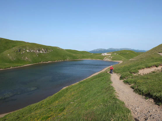
The path along the edge of Lago Scaffaiolo (Walk 6)
The path along the edge of Lago Scaffaiolo (Walk 6)
The Pistoia district is a quiet hilly corner in the centre of northern Tuscany, well worth exploring for its pretty villages of old stone houses, and easily accessed thanks to the Florence–Lucca railway. The greatest drawcard here is a storybook about the wooden puppet-turned-boy, Pinocchio. He was the invention of 19th-century Tuscan author Carlo Lorenzini, who chose to use the name of his mother’s village, Collodi, as his pen name. Carlo Collodi’s The Adventures of Pinocchio continues to be a bestseller, and has been translated into 260 languages!
Walk 4 links the village of Collodi with Pescia. Both have a dual existence. Pescia has grown up on parallel banks of the eponymous river, while Collodi is composed of a medieval alto (upper) part with a ruined castle, near-vertical pedestrian-only streets and tiny stone houses cascading dizzily down the hill, and a basso (lower) area with transport and facilities as well as the stately Villa Garzoni with its ornamental gardens. Pinocchio enthusiasts can also indulge themselves at the Parco di Pinocchio theme park (www.pinocchio.it).
To the north of Pistoia, the landscape becomes steeper with the foothills of the Apennines. The River Reno rises north-west of the city near the hill village of Le Piastre, before flowing northwards, destination Bologna. In winter, its valley channels chilly winds and receives little sunshine, perfect conditions for making ice. In the late 1700s, the ingenious local people began to exploit this; they directed water off the river into a shallow artificial lake, then each morning the frozen surface would be broken up into slabs and slid into a conical ghiacciaia (ice house) for storage, the layers separated by chestnut leaves. An impressive reconstructed ice house is a great attraction on the opening stretch of Walk 5.

Commemorative pyramid at the Abetone pass (Walk 7)
A huge boost for ice distribution came in 1781, a landmark year, with the completion of the Pistoia–Modena road. This was funded jointly by the Grand Duke of Tuscany and the Duke of Modena to connect their powerful regions, opening up trade and transport routes from the port of Livorno to northern Italy – bypassing the Papal States. The key pass is the Abetone, at 1388m, named after a colossal fir tree that was felled to make way for the historic road. Such was the girth of the tree that six men’s outstretched arms were insufficient to completely encircle it!
The road cuts across the elevated ridge of the central Apennines. These act as Tuscany’s northern border with Emilia-Romagna, and are regularly battered by winds and shrouded in low cloud. Thick beech and conifer woods creep up the steep slopes, and sheep and goats graze on the extensive medium-altitude grasslands where the plants are decidedly alpine. Inviting walks in the vicinity of the Abetone include a jaunt to Lago Scaffaiolo (Walk 6) and the Libro Aperto peak (Walk 7).
Continuing north-west and high above the Garfagnana valley is Tuscany’s maximum elevation, Monte Prado (2054m), a superb peak for walkers and the goal of Walk 9. This is the Parco Nazionale Appennino Tosco-Emiliano. Not far away is the charming mountain hamlet of San Pellegrino in Alpe, occupying a spur slightly below the main ridge; a grand total of 15 people call it home all year round. The Romantic poet Shelley is remembered here, as the mountains and sky inspired him to write The Witch of Atlas in 1820.
The village was formerly the site of a hospice, providing shelter for pilgrims and traders in the early Middle Ages. It was purportedly founded by San Pellegrino (son of a Scottish king), whose embalmed body lies in the church and who is also connected with the Giro del Diavolo (devil’s circle), visited in Walk 8. The former hospice is now a Museo Etnografico, a fascinating assortment of 4000 household and farm objects such as rakes for gathering bilberries and unusual wooden mousetraps.
The south-eastern section of the Tuscan Apennines is covered in Chapter 4.
Pistoia is a good base for visiting the area thanks to the railway line and bus services, and it has plenty of accommodation. Not far away is Pescia, with trains and local buses as well as a hotel. The Abetone road pass is another good spot to stay; it has bus links with the railway line at Pistoia.
Tiny San Pellegrino in Alpe has accommodation but limited bus transport. You could always stay down at Castelnuovo di Garfagnana, which has a decent range of accommodation as well as trains and buses and is also suggested as a base for Chapter 3.
| Start/Finish | Collodi |
| Distance | 9.8km |
| Ascent/Descent | 550m |
| Grade | 1–2 |
| Walking time | 3hr |
| Map | Kompass n.2439 Toscana Nord 1:50,000 map 2; or Kompass n.2440 Toscana 1:50,000 map 1 |
| Access | BluBus links Pescia and its railway station with Collodi; this is supplemented by a local shuttle bus in summer. |
| Note | The walk is unsuitable in wet weather as the paved stretches could be slippery. |
An unforgettable walk through delightful hill villages and lovely wooded countryside in Pinocchio land. Collodi has all facilities including souvenir shops galore, while Pescia has eateries. Before setting out, don’t miss the world’s tallest Pinocchio statue (near the main bus stop) – an awesome 16m high, crafted from a Swiss pine tree and inaugurated in 2009.
There is not much waymarking on the outward stage to Pescia, so follow directions carefully. For a shorter easier variant, walk from Pescia to Collodi (allow 1hr 15min) and return by bus.


Collodi boasts the world’s tallest Pinocchio statue (16m)
From the Tourist Office and bus stop in Collodi basso (125m), near the entrance to the gardens of Villa Garzoni, take the broad paved pedestrian way, Via per Collodi Castello. It wastes no time in climbing N, flanking the garden walls, and up past an entrance to the villa, which towers above. As you meet the road, go R (in Collodi alto now) into Piazza San Antonio. Then keep uphill on near-vertical Via Lungo Ovest. You puff past tiny well-kept houses, through Piazza della Fontana, and continue on Via Grazia Deledda. Further up at a church is a panoramic bench where you can get your breath back. Now Via Pietro Nenni leads the final metres to a tower and what’s left of the castello, then out through an arch to a narrow surfaced road.
Turn R (ignoring the first lane L) to where the road veers R at a three-way junction. Go first L here past a car park/clearing on a good lane, soon bearing R (E) through olives and climbing gently into woodland. After a panoramic corner, it’s N to where the way forks at a wooden cross (475m). Branch R on a minor but clear track down to a bend where a faded sign points to a spring, Fonte di Viamaggio. Not far uphill is a saddle and lane junction – take the lane straight ahead (E at first) in descent through chestnut woods. Where it forks, go R, soon passing a house and descending amid olive trees into Monte a Pescia (323m, 1hr 20min).
As you leave the village, turn L through the car park then go immediately R on Via del Monte Est, past house n.16. A beautifully preserved old way winds downhill SE through tidy olive groves. At forks, follow the paving and occasional red-and-white waymarks. The cluster of houses at Barignano is followed by a chapel then the high wall of a villa. Down at a minor road and gate, keep R below the tarmac alongside a high wall to reach houses and the edge of Pescia. Here, a narrow road leads straight ahead (S) between houses and under an archway. At the bottom of the hill, go R past the church in Piazza di S Stefano leading through to Piazza degli Obizzi then Ruga degli Orlandi. Here, you need the first alley L through to the Tourist Office of Pescia (66m, 30min) in Piazza Mazzini.
The old paved way down to Pescia
The marvellous Piazza Mazzini is a broad street-cum-square lined with shops and cafés. At the far end of the square, remember to look to your left for a glimpse of the other half of Pescia, beyond the river.
Continue through to Piazza Matteotti and a park. There, go R past the cinema to where Via della Cappella breaks off L, signed for Via della Fiaba.
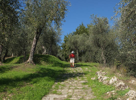
The lovely old pedestrian way climbs a little at first before coasting easily, mostly W, past villas, olive groves and an old shrine. You emerge at a road and continue straight ahead past a rusty iron cross. The path soon joins a minor road (R) to where the paved lane resumes, through to a historic stone bridge. An uphill stretch passes close to a white shrine as well as more olive trees and shady woodland.
After a minor road crossing, the path is lined with bay trees and olives. Where a broad paved leg bears L down to the local cemetery, ignore it and keep R past more palms and olive plantations. The way narrows a little to reach tall stone walls belonging to the gardens of Villa Garzoni. At a fork, turn L down an atmospheric if knee-challenging paved alley that runs into the outward route, concluding down at the bus stop in Collodi basso (1hr 10min).
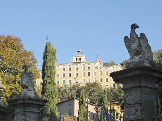
Marvellous Villa Garzoni divides Collodi basso from Collodi alto
| Start | Le Piastre |
| Finish | Pontepetri |
| Distance | 9km |
| Ascent | 170m |
| Descent | 250m |
| Grade | 1–2 |
| Walking time | 2hr 15min |
| Map | Kompass n.2439 Toscana Nord 1:50,000 map 2 |
| Access | BluBus connects Pistoia railway station with Le Piastre. At the walk’s end, catch a BluBus either back to the start or to nearby Pracchia for trains (Prato–Bologna line). For the local taxi service, tel 339 7717899 or 348 4804077. |
Industrial archaeology is the theme of this walk, which visits a unique reconstructed ghiacciaia (ice house) near the village of Le Piastre, once a thriving centre of ice production. If feasible, time your walk so as to enjoy a guided visit to the Ghiacciaia della Madonnina (tel 0573 97461 or 0573 638025 www.ecomuseopt.it). At the other end of the walk, the lively village of Pontepetri stands between two small rivers, the Reno and Torrente Marasca, which were used in the past to power an ironworks; a museum can be visited here too.
The walk described here is a straightforward stroll along lanes and paths. The modest river is forded in one spot – a simple crossing in normal conditions. Use a walking pole or a stick if you feel uncertain, and watch your step after heavy rain. Both Le Piastre and Pontepetri have shops and eateries.
From the bus stop at Le Piastre (740m), walk down to the car park and Ecomuseo signs, then turn R along the road to where you turn R again (E) at the signed start of the Sentiero della Ghiacciaia (ice house route).
A shady path follows the modest River Reno, criss-crossing it on timber bridges. Not far along is the Ponte dell’Angiola, an elegant stone bridge belonging to the historic road that runs parallel to your route at this point. The next point of interest is an old water-powered mill, once used for making chestnut flour. Close by is a small sluice gate and a channel, or gora, which you follow to the shallow artificial lake alongside the fascinating Ghiacciaia della Madonnina (720m, 20min).
Measuring 15m in height and with a capacity of 700m3, the reconstructed ice storage house Ghiacciaia della Madonnina has solid masonry walls and a thatched roof (redone in 2012), and was originally but one of 70 such structures. Water from the river was run off into the adjacent lake, where the ice formed and was then cut into slabs for storage.
Ice production took place here from the late 1700s until World War II and the advent of industrial iceworks. The lake bottom was concreted over in the early 1900s due to concerns over hygiene.
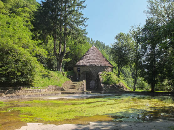
The Ghiacciaia della Madonnina and its artificial lake
The path leaves this spot and soon fords the river on large stone slabs. Keep R at the next fork on a lane climbing gently NE through shady woodland dominated by hazel and dotted with wildflowers. The way bears briefly S to cross a side stream. Here, you ignore a turn-off (signposted ‘Laghi pesca sportiva’, a fishing reserve in a former ice lake). At a nearby T-junction (the R branch returns to Le Piastre), go L past masses of ferns, in steady ascent in the company of chestnut trees. Ignore turn-offs.
An antenna and an old stone wall precede a saddle and a four-way junction (750m, 1hr 15min). Continue N uphill on the widest lane (with red-and-white waymarks) lined with beech trees along the broad ridge. When you encounter tarmac at a fork (Castellino), go R (NE) then soon sharp L to leave the ridge on a plunging rough stony lane N. The village of Pontepetri comes into view ahead.
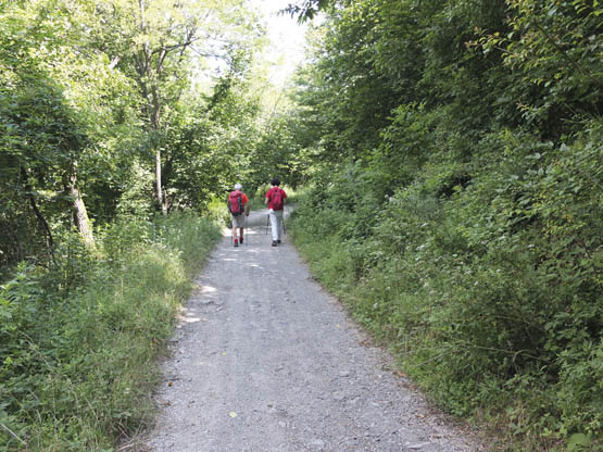
A good lane leads through wood towards Pontepetri
Down in the Reno valley, ignore turn-offs and stay with the lane leading through to the Fonte del Duca, a source of cool refreshing water that was evidently appreciated by the Grand Duke of Tuscany. Go L to cross the River Reno and up to the road at Pontepetri (669m, 40min). Turn L for the bus stop and eateries.
| Start/Finish | Cable car station, Doganaccia |
| Distance | 7.5km |
| Ascent/Descent | 250m |
| Grade | 2 |
| Walking time | 2hr 30min + 2hr extension |
| Map | SELCA Alto Appennino Modenese 1:25,000; or Kompass n.2439 Toscana Nord 1:50,000 map 2 |
| Access | A cable car runs up to Doganaccia (late June to early Sept) from Cutigliano, which is on the Abetone road and served by year-round Copit buses (Pistoia–Abetone). Should you prefer to drive all the way to Doganaccia, take the narrow, winding 15km road from Cutigliano. |
This excellent straightforward circuit heads up to the main Apennine ridge for a photogenic lake and a superbly placed rifugio (mountain hut). The return is via another panoramic pass before dropping back to the cable car. A must-do extension to the summit of Corno alle Scale (1945m) is given for fit walkers.
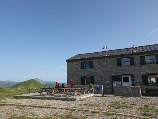
Apart from the hopefully good views, another excellent reason to come is hospitable Rifugio Lago Scaffaiolo, also known as Duca degli Abruzzi after the great 19th-century Italian explorer and mountaineer.
From the cable car station at Doganaccia (1547m), you need path n.66 past the modest church. Cutting over a lane, it heads mostly E crossing the grassy slopes beneath Monte Spigolino, and past a spring. It’s not far to Passo Calanca (1737m), where you join the main watershed ridge dividing Tuscany and Emilia-Romagna.
Turn R on path n.00, which doubles as the long-distance Grande Escursione Appenninica (GEA) trek, leading SE to Lago Scaffaiolo (1790m). Set in a shallow depression, this is either a sparkling blue lake or a shallow muddy pond, depending on weather conditions. Walk along the L shore to Rifugio Lago Scaffaiolo (1hr 15min).
Rifugio Lago Scaffaiolo
The name Scaffaiolo derives from caffa, an old word for a natural basin. The unassuming lake is the subject of murky stories about amazingly strong winds that come driving in unannounced from the west, gusting to the tune of 120km per hour. It was claimed that even a pebble cast into the waters would stir up thick mist and unleash mighty storms, a belief immortalised by 14th-century writer Giovanni Boccaccio. Moreover, it was long held that the lake was linked to the sea by a hidden channel.
Pick up n.00 as it moves off SE below Il Cupolino and coasts around the upper edge of a lovely glacially modelled pasture basin. You go through Passo dei Tre Termini, where Hannibal reputedly transited with his army and a single elephant in 217BC. Ups and downs lead to Passo dello Strofinatoio (1847m), where path n.129 wastes no time heading due N uphill to the broad uppermost sandstone crest (with a chairlift) on Corno alle Scale (1945m).
Return the same way to Passo dello Strofinatoio and Rifugio Lago Scaffaiolo.
From the rifugio, retrace your steps past the lake and back on n.00 along the ridge to Passo Calanca. Now take the middle path on level ground around Monte Spigolino and towards a cluster of aerials. Down a slope of grass and bilberry shrubs you reach a World War II memorial, complete with artillery, at Passo Croce Arcana (1670m, 1hr).
During the time of the Lombard Kingdom (6th–8th century AD), Passo Croce Arcana was a strategic pass between the Po plain and the Tuscan coast. In 1479 it witnessed the passage of 2000 horses and 500 foot soldiers belonging to a Milanese army, and was even paved in 1633.
Here, you leave the n.00 ridge route and turn L on the lane S for the return to Doganaccia and the cable car (15min).
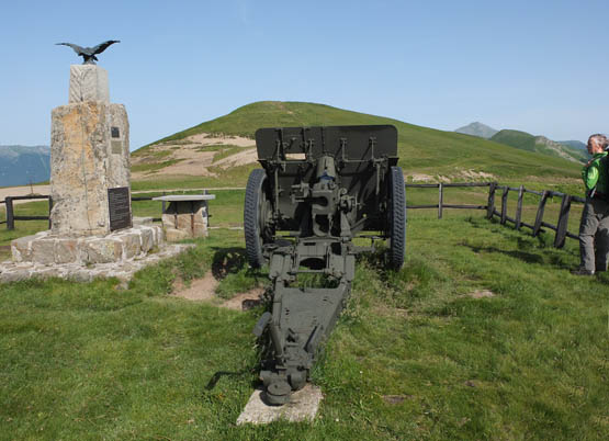
Passo Croce Arcana has a World War II memorial
| Start/Finish | Abetone |
| Distance | 10.6km |
| Ascent/Descent | 650m |
| Grade | 2 |
| Walking time | 4hr |
| Map | SELCA Alto Appennino Modenese 1:25,000; or Kompass n.2439 Toscana Nord 1:50,000 map 2 |
| Access | Year-round Copit buses from Pistoia serve the Abetone pass. |
The Libro Aperto is a marvellously scenic yet easy-to-reach outcrop located east of the Abetone road pass. Its name, meaning ‘open book’, becomes clear if the mountain is viewed from the north, as the arenaceous rock layers look decidedly like pages. It’s a steady climb on lanes and paths through the conifer thickets of a forestry reserve to open terrain where the going gets stiffer, but all effort is amply rewarded with fantastic views along with masses of colourful wildflowers. Go equipped with sun protection and a picnic; there is drinking water en route.
The walk begins at two small pyramids at the Abetone pass, erected on the borders of the duchies of Modena and Tuscany to commemorate the historic road. During the walk, smaller stone border markers can be seen set along the main ridge.
From the pyramids at Abetone (1388m), leave the main road and walk N up the tarmac to a branch off R with a traffic barrier and hut. This is n.00, a well-graded forestry lane that doubles as a cross-country ski track in winter. A leisurely stroll leads NNE to reach a stone fountain and path junction.
Now a path takes over, in gentle ascent across wooded Monte Maiore (1560m) before a short drop to a lane and La Verginetta (1503m), a modest shrine. Not far along is a hut on the upper tree line where path n.00 suddenly assumes what feels like a near-vertical gradient. It proceeds E, sticking close to the open ridge. At a 1860m saddle and path junction, bright with pink thrift flowers, keep puffing on up for the final metres. The reward is Monte Rotondo (1936m), the highest of the two tops of Libro Aperto (2hr 10min).
The views from here are vast. Due north is Monte Cimone (2165m), recognisable for its clutch of aerials, while vast sections of the Apennine chain can also be admired. On crystal clear days, the Alps will also be visible.
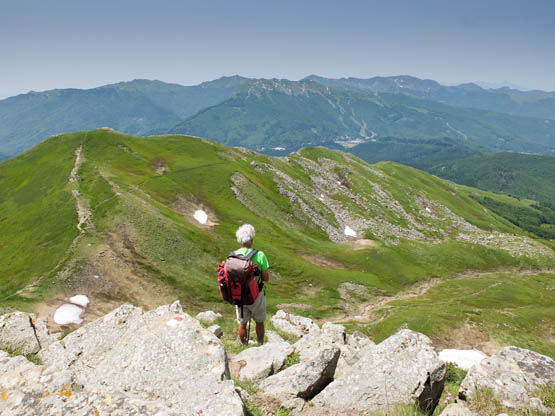
There are vast views from Libro Aperto over the Apennines
Taking great care on the steep descent, retrace your steps back down to the Abetone pass (1hr 50min).
| Start/Finish | San Pellegrino in Alpe |
| Distance | 4km |
| Ascent/Descent | 300m |
| Grade | 1 |
| Walking time | 1hr 30min |
| Map | SELCA Alto Appennino Modenese 1:25,000; or Kompass n.2439 Toscana Nord 1:50,000 map 2 |
| Access | For visitors without a car, San Pellegrino in Alpe has the occasional CTTNord bus from Castelnuovo di Garfagnana. |
This delightful stroll is feasible for all ranges of walkers. It begins at the sleepy hamlet of San Pellegrino in Alpe and makes its easy way across open mountain slopes to the curious Giro del Diavolo, site of pilgrimages. This is close to the main Apennine ridge and the outlook is magnificent. Take a picnic from San Pellegrino to make the most of it.
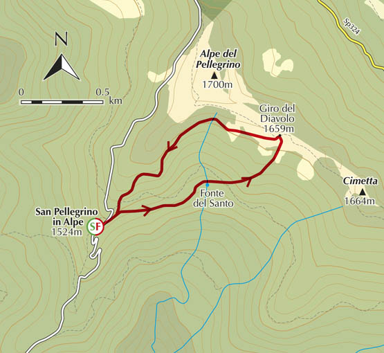
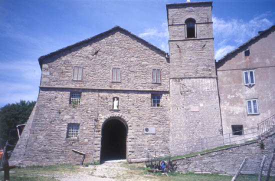
The ancient hospice and sanctuary at San Pellegrino in Alpe
From the lower part of the village of San Pellegrino in Alpe (1524m), close to La Taverna del Pellegrino, turn L at the sign for Fonte del Santo. This leads down an unsurfaced road; but only minutes on, take the steps R down to a parallel path just below the road. This takes you to the spring Fonte del Santo (1475m).
Next, turn L uphill and cross the road, passing the L side of a farm building on a faint track; the rough hillside is known as Prato Bello. Not far up, a red-and-white marked path takes over, climbing easily through woodland to emerge on open pasture at the Giro del Diavolo (1659m, 1hr) and the spreading heaps of stones left by scores of pilgrims. Wonderful views are further reward.
A widely believed legend explains how the Giro del Diavolo (devil’s circle) acquired its name. The devil tried his utmost to lead the young San Pellegrino into temptation, but in vain. Infuriated by his failure, Lucifer slapped him so hard that he twisted round and round in dizzy circles.
The devout come up here in penitence carrying stones – the worse the sin, the bigger the stone! After lugging their burden thrice around the site in recognition of the saint’s ordeal, they add them to the heap seen today.
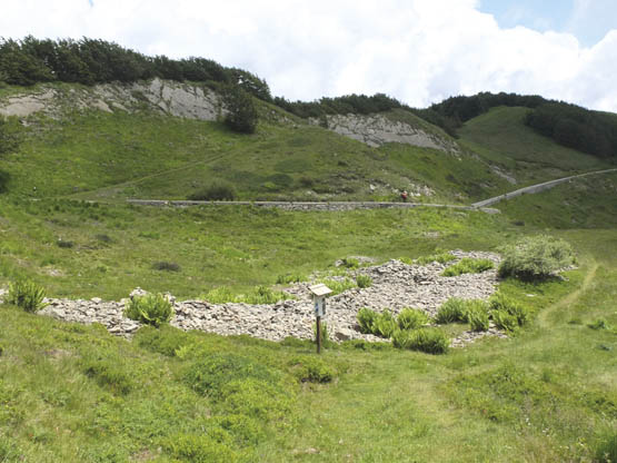
Heaps of stone left by pilgrims at the Giro del Diavolo
From the nearby marker column, an easy path (n.50) heads mostly W before descending steadily SW through woodland and back to lovely San Pellegrino in Alpe (30min).
| Start/Finish | Casone di Profecchia |
| Distance | 16.5km |
| Ascent/Descent | 1050m |
| Grade | 2 |
| Walking time | 6hr 30min |
| Map | Kompass n.2439 Toscana Nord 1:50,000 map 2 |
| Access | The occasional CTTNord bus from Castelnuovo di Garfagnana to Passo delle Radici stops at Casone di Profecchia. Car owners who don’t mind a bumpy unsurfaced road can drive further, as far as Rifugio Cella – a saving of around 2hr. |
This superb if lengthy circuit climbs through woods and carpets of wildflowers to the Apennine ridge, where it joins the long-distance Grande Escursione Appenninica (GEA) trek. The day’s highlight is Monte Prado (2054m), the highest elevation in the whole of Tuscany and a great lookout taking in the spectacular Alpi Apuane. Afterwards, the walk drops in on friendly Rifugio Battisti before traversing veritable meadows of bilberries and picking up a section of the outward route.
Food and drinks can be enjoyed at the hotel/restaurant Il Casone at the start and (in summer) at Rifugio Battisti.
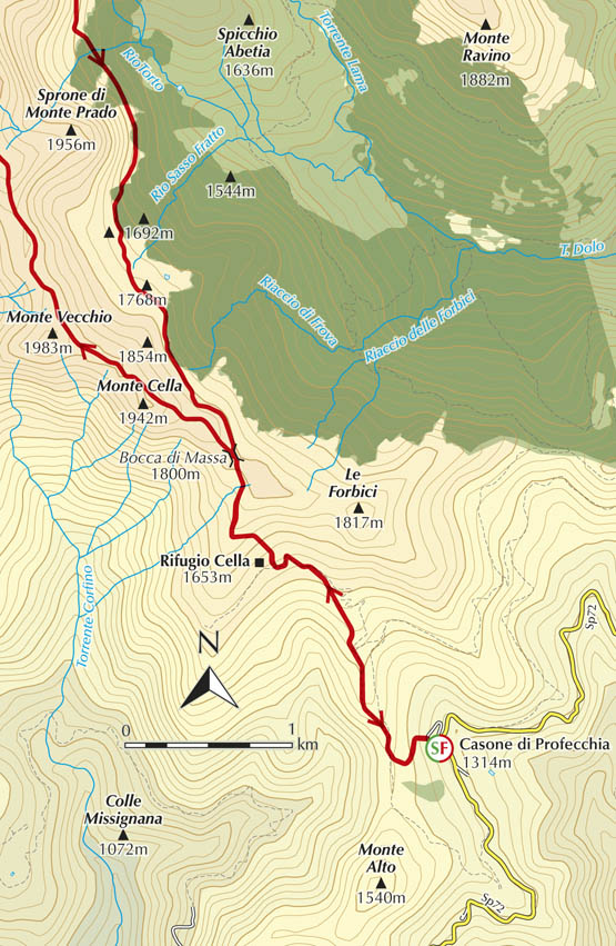
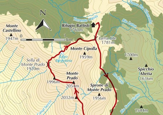
From Casone di Profecchia (1314m), take path n.54 heading past ski structures and NW through beech woods, cutting the many curves of the forestry road. This terminates at a parking area near the shepherds’ residence Rifugio Cella (1653m, 1hr 10min). Here, a clear well-trodden path (still n.54) strikes out mostly N. Enjoying vast views, it climbs gently across grassland and heath to gain the main ridge at a huge stone marker at the windswept pass Bocca di Massa (1800m). Now turn L (NW) on n.00 to the iron cross and rock graffiti on Monte Cella (1942m).
The next landmark is Passo degli Scaloni (1922m). This is followed by a gentle ascent guided by cairns to the summit of Monte Prado (2054m, 1hr 50min).
Overlooking a glacially formed basin, the summit of Monte Prado is a brilliant spot offering 360-degree views. To the north-west, the views include the bulky and elongated shape of Monte Cusna, which, according to legend, is the reclining body of a kind-hearted giant, sheltering flocks from the fury of the winds.
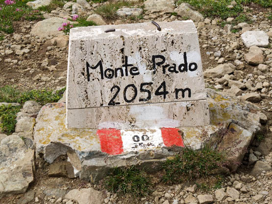
Monte Prado is the highest point in the whole of Tuscany
Now it’s decidedly downhill to the broad saddle Sella di Monte Prado (1920m). Here, you leave the ridge and follow n.631 in descent to an inviting picnic spot at the pretty tarn Lago Bargetana (1777m). The path continues along the foot of Monte Cipolla to the key saddle Lama Lite (1781m).Take the signed jeep track circling a knoll to reach Rifugio Battisti (1761m, 1hr 20min).
Return to Lama Lite, where you need n.633 leading SSE through Valle dei Porci (no translation needed) and swathes of bilberry shrubs. After rounding the ample base of Sassofratto, the undulating route criss-crosses lovely streams lined with marsh marigolds through to Bocca di Massa (1hr 10min). Now return downhill on n.54 via Rifugio Cella and back to Casone di Profecchia (1hr).
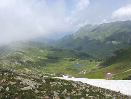
Lago Bargetana and Monte Cusna can be admired from Monte Prado