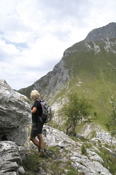
The Foce Carpinelli pass is a superb lookout over the Alpi Apuane
The Foce Carpinelli pass is a superb lookout over the Alpi Apuane
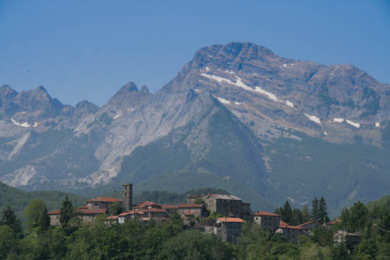
The northernmost pocket of Tuscany is quite a contrast to the rest of the hilly region. A seagull’s flight inland from the Tyrrhenian coast is the formidable barrier of the rugged Alpi Apuane, slotted in between the sea and the mighty Apennines and rising abruptly, almost to 2000m. These surprisingly wild ‘Alps of Tuscany’ are 50km long with steep flanks and razor-sharp ridges that make for challenging albeit spectacular walking. They also boast pockets of brilliant white Carrara marble, extracted since Roman times and prized by Renaissance artists such as Michelangelo. Nowadays the area is partly protected by a Parco Regionale (www.parcapuane.it), flanked by quarries mostly on the western edge.
An excellent introduction to the Alpi Apuane – or the Apuan Alps as they are occasionally referred to – is the drive up the winding, narrow and superbly panoramic road from Aulla (a short distance inland from La Spezia). It climbs east via the Foce Carpinelli pass, where a good section of the northern chain can be admired, including Pisanino (1947m), the highest peak. The ensuing descent leads into the lovely wooded Garfagnana valley, dotted with villages and traditions, and centred around Castelnuovo di Garfagnana and the Serchio river, which flows south to Lucca. A train covers a similar route. Buses provide access to the walks described here, in the southern Apuane. Walk 10 begins above Fornovalasco while the mountain village of Palagnana is the start for Walks 11 and 12.
Castelnuovo di Garfagnana is a handy base as it is on the Lucca–Aulla railway line and buses branch out to the outlying mountain villages. It has a decent range of accommodation, although you could always stay up at Fornovalasco.
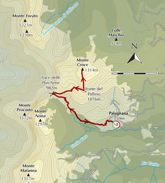
Foce di Valli (Walk 10)
| Start/Finish | Car park above Fornovolasco |
| Distance | 13km |
| Ascent/Descent | 850m |
| Grade | 3 |
| Walking time | 5hr 30min |
| Map | Edizioni Multigraphic Alpi Apuane 1:25,000 sheets 101–103; or Kompass n.2439 Toscana Nord 1:50,000 map 1 |
| Access | From Fornovolasco (CLAP bus this far), follow ‘Grotta del Vento’ signs for 1.5km. As the road crosses a stream (Turrite di Gallicano), at a sign for the Parco Alpi Apuane, turn off L and park near the signposts for paths n.6, 12 and 130. |
| Note | The route should be avoided in high winds and bad weather as the long traverse from Foce di Valli to Foce di Petrosciana is narrow and exposed in spots. |
A superb circuit for walkers who have some experience of exposed paths, this takes in a spectacular crest that looks down to the glittering Tyrrhenian coast and affords excellent views to the southern cluster of Apuane peaks as well as the Apennines. The undeniable highlight is Monte Forato, a natural arch 36m wide and 16m high – an awesome window. A light plane has reportedly flown through the opening! The walk also features vast spreads of wildflowers, deer in the woodland and shy mouflon on the high rocky reaches. All the paths are clearly marked with CAI red-and-white stripes, which need to be followed closely in woodland.
The village of Fornovolasco has a restaurant with accommodation.
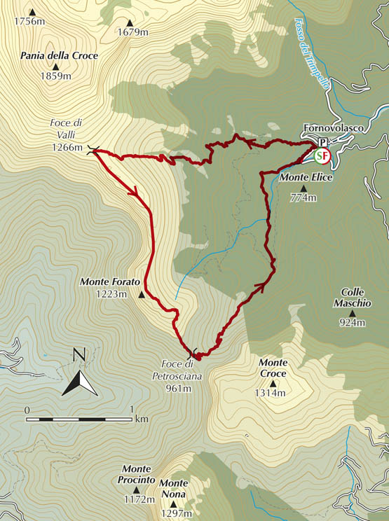
From the car park (540m), take n.130, a lane along the R side of the stream. It soon forks R and curves past stacks of firewood, high above Fornovolasco. Around the corner, take care not to miss the signed fork sharp L (W). The path leads up a steep wild hillside and into woods of chestnut and other deciduous trees, climbing steadily, never letting up. En route are several ruined houses.
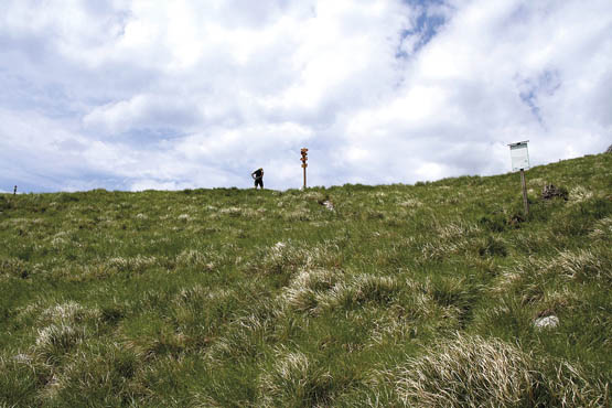
After more beech woods and platforms left by charcoal burners, the path finally emerges on a grassy slope. Ignore the fork L for n.131 and continue up meadows of narcissus and gentians, accompanied by skylarks, to the rugged crest and Foce di Valli (1266m, 2hr 15min).
At Foce di Valli, breathtaking views to the Tyrrhenian Sea await. Adjacent to the pass and dominating the vast expanse of Costa Pulita (clear slope) rise the dizzy walls of Pania della Croce and its neighbour Pania Secca to the north-east. The two are united by the curiously named rock formation Uomo Morto (dead man), although it bears a closer resemblance to the profile of that great Italian poet Dante. Further east stretch the Apennines.
Turn L (SSE) on n.110 for the spectacular route – with several hands-on sections – that sticks close to the rocky ridge. En route, wild pink peonies may be admired, clinging to the edges of near-vertical gullies. Monte Forato (1223m, 1hr) with its soaring arch is an unmissable photo stop.
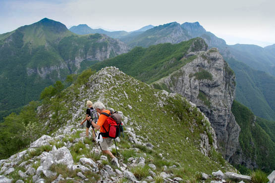
The route from Foce di Valli hugs the rocky ridge

The soaring arch of Monte Forato
Path n.110 now heads through beech woods on the L side of the crest. At a rocky saddle about 10min along, the marked path forks sharp R downhill – check for markings on trees. It then proceeds to climb R around Monte Forato and past the start of a via ferrata. A rocky hands-on section follows, then it’s back to the cover of the woods. After a length of guiding cable, it’s not far at all to the path junction and saddle Foce di Petrosciana (961m, 1hr).
Foce di Petrosciana is a brilliant spot looking east-south-east to Monte Croce and south to the vast incline of Monte Nona, although your eye will naturally be drawn south-west to the dramatic sculpted shape of Monte Procinto. A road was once planned through here, but thankfully never saw the light of day.
To start the descent, fork L on n.6 and it’s soon down to a dry stream bed in beech woods where you ignore the n.137 turn-off. The clear if narrow path drops mostly NNE, criss-crossing the valley and soon reaching a rough lane. Stick to the waymarked route. Further down (around 700m) water suddenly reappears and Turrite di Gallicano begins flowing, thanks to natural springs. There’s even an old mill soon, as well as a waterfall and inviting pool in a side valley. The path goes N on this atmospheric stretch, soon joined by n.12 (the steep direct route from Monte Forato). A scattering of huts and a paved lane will see you back at the car park above Fornovolasco (1hr 15min).
There are some narrow passages on the ridge
| Start/Finish | Palagnana |
| Distance | 7.4km |
| Ascent/Descent | 650m |
| Grade | 2–3 |
| Walking time | 3hr 10min |
| Map | Edizioni Multigraphic Alpi Apuane 1:25,000 sheets 101–103; or Kompass n.2439 Toscana Nord 1:50,000 map 1 |
| Access | Palagnana is at the end of a very narrow road via Fabbriche di Vallico. Amazingly, a CLAP/VAI bus comes up this far. |
Monte Croce is renowned for its superb wide-ranging views along with magnificent carpets of wildflowers. In late springtime, walkers and botanists alike flock up here to admire the white Narcissus poeticus (poet’s narcissus), informally dubbed gir la testa (head-turner) because of its intense perfume. The mountain, on the other hand, was possibly named for its shape, as four ridges converge at the summit forming a cross (or croce).
The walk as far as Foce delle Porchette is in common with Walk 12. Grade 2–3 applies to the central section incorporating Le Scalette, a rough rock stairway with a hands-on stretch. Palagnana, where the walk starts and ends, has a rustic café/restaurant.
From the car park and bus stop at Palagnana (759m), walk up the asphalt out of the village and branch L (W) following waymarks for n.8, soon on a dirt road. After a couple of houses in woodland, the lane reverts to its older self, a paved mule track, and climbs steadily, perfectly graded. Out of the trees is the pass Foce delle Porchette (982m, 45min) and its shrine.
The curious name of Foce delle Porchette, a key passage between the Garfagnana and Versilia regions, derives not from ‘pig’ but from proche, a local term denoting the man-made cultivation terraces in the vicinity.
Fork R (due E) here on n.108 below the crest, past laburnum and rowan trees. Not far along is a gully where the way ascends L as steps hewn out of the rock (Le Scalette) and narrow passages with the odd stretch of guiding chain. This emerges on grassy terrain once again at Fonte del Pallino (1076m, 30min).
Fork R and soon L (N) following blue waymarks for the steep slog up grassy slopes strewn with wildflowers. This concludes at the summit cross on Monte Croce (1314m, 40min), with its marvellous panorama stretching from the Tyrrhenian Sea and across the entire central section of the Alpi Apuane, with the Apennines spread out in the east.
Return the same way to Foce delle Porchette then Palagnana (1hr 15min).
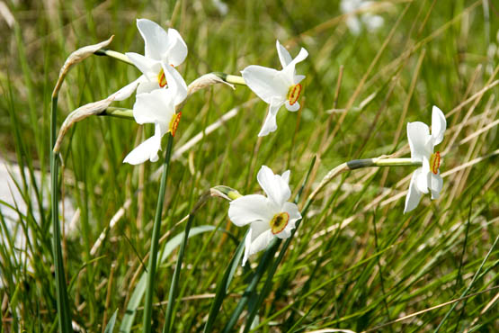
Monte Croce is famous for its thick carpets of narcissus
| Start/Finish | Palagnana |
| Distance | 10km |
| Ascent/Descent | 700m |
| Grade | 2–3 |
| Walking time | 4hr |
| Map | Edizioni Multigraphic Alpi Apuane 1:25,000 sheets 101–103; or Kompass n.2439 Toscana Nord 1:50,000 map 1 |
| Access | Palagnana is at the end of a very narrow road via Fabbriche di Vallico. Amazingly, a CLAP/VAI bus comes up this far. |
This walk is a remarkably varied loop through beautiful woodland. Good marked paths are taken, and walkers enjoy flourishing woodland, tons of wildflowers and wonderful views over mountains, villages and, last but not least, the Tyrrhenian Sea.
As far as practicalities go, Palagnana has a café/restaurant, while en route is a rifugio with meals and drinks, then further along is another café/restaurant, Alto Matanna. Otherwise take your own picnic.
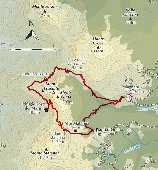
From the car park and bus stop at Palagnana (759m), walk up the asphalt out of the village, and branch L (W) following waymarks for n.8, which quickly becomes a dirt road. Path n.3 soon forks off L – ignore this for now (the return route slots in here later). The lane passes a couple of houses in woodland then reverts to a paved mule track self, climbing steadily at a perfect gradient. Out of the trees is the pass Foce delle Porchette (982m, 45min) and its shrine.
Foce delle Porchette is a key passage between the Garfagnana and Versilia regions. The views from here are superb, embracing the soaring Pania della Croce (north-north-west) and the village of Cardoso (west), beyond which rises Antro del Corchia, beset with quarries.
The curious name of the pass derives not from ‘pig’ but from proche, a local term denoting the man-made cultivation terraces in the vicinity.
Take path n.8, a lovely well-graded route winding down through beech woods. Keep L (SW) at the first junction and past a spring (Fonte Moscoso). Soon you need n.6 (signed for Rifugio Forte dei Marmi), then L again on n.121. A tad narrower, this circles the base of Monte Procinto, visiting an excellent lookout popular with weekend picnickers. Soon it’s SE, and massive Monte Matanna comes into view to the south. Further on, a better path is joined at a fountain, shrine and clutter of signposts. Keep straight on (n.5) past the turn-off for Callare di Matanna and head for nearby Rifugio Forte dei Marmi (865m, 1hr 30min), ensconced in conifer forest at the foot of Monte Nona.

The stone cylinder of Monte Procinto
Backtrack briefly to the signed turn-off R for n.5 to start the ascent, N at first, on a path inaugurated in 1890. Ahead, the immense stone cylinder of Monte Procinto can be clearly admired, while above rises the seemingly impassable sheer rock face of Monte Nona.
The path veers R (SSE) accompanied by the odd stretch of guiding cable. Past a shoulder is a curious natural triangular cleft, dubbed Camera degli Sposi (chamber of the newly-weds). Not far on is the pass Callare di Matanna (1139m, 45min), with a pylon and crucifix.
It’s not far down the other side on n.5 to café/restaurant Alto Matanna (1036m, 10min). Keep R through the car park and onto the road. About 5min down the tarmac, fork L on n.3. At the nearby hamlet Piano d’Orsina (981m), veer L into the woods for a rocky path downhill to a stream. Continuing NNE, this eventually becomes an old lane, climbing back out at the dirt road followed at the walk start. Go R here and back to Palagnana (50min).
The café/restaurant at Alto Matanna