The beautiful Camaldoli forest (Walk 15)
The beautiful Camaldoli forest (Walk 15)
Immediately to the east of Florence, this is a region of mountainous terrain cloaked in ancient forests and dotted with monasteries and spiritual retreats – sites dear to the Etruscans.
First is the Pratomagno. Visitors to Tuscany rarely notice the elongated mountain looming over Valdarno as they ride the train south to Arezzo, unknowingly passing beneath its superb conifer and deciduous forests. These were nurtured since early medieval times by the monks of Vallombrosa (shady valley) for commercial ends. Now an Italian State Forestry Reserve, the trees – predominantly silver fir – continue to supply valuable timber for the thriving artisan furniture workshops in neighbouring villages.
The late 1800s saw the construction of ‘Little Switzerland’, namely the old-style hill resort of Saltino, set on a superbly panoramic corner at 1000m, where it seems like the whole of Tuscany is at your feet. A rack-and-pinion train linked it with the valley floor until World War I, when buses took over. Nowadays Saltino has but 15 permanent residents, and the 1892 Grand Hotel is still accepting guests. Walk 13 starts out here to explore the forest and Pratomagno.
A woodpecker’s flight away to the north-east, spread along the lofty Apennine crest, are yet more monumental forests of chestnut, fir and beech in the 364km2 Parco Nazionale delle Foreste Casentinesi (www.parcoforestecasentinesi.it). In the past, the timber was an immensely valuable resource: it was fashioned into scaffolding for landmark Florentine monuments such as the massive Duomo and used to build sturdy ships for the navies of Livorno and Pisa.
The highest point is Monte Falco (1657m). This natural lookout is visited in Walk 14, which also takes in the source of the Arno before the river heads out west, gaining in volume to flow through Florence and clocking up 240km before emptying into the Tyrrhenian Sea near Pisa.
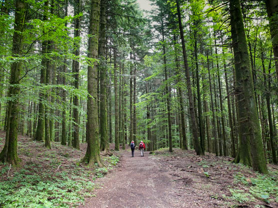
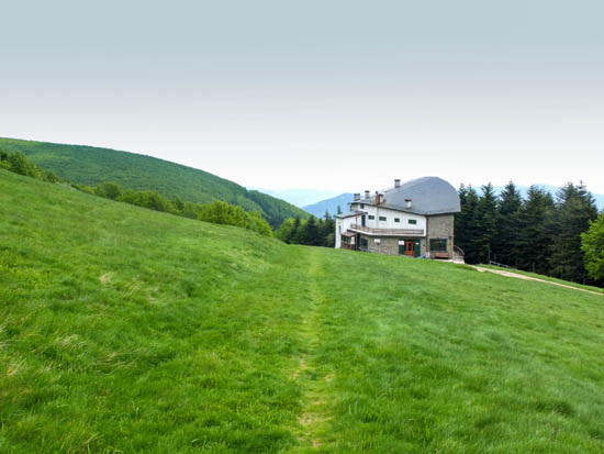
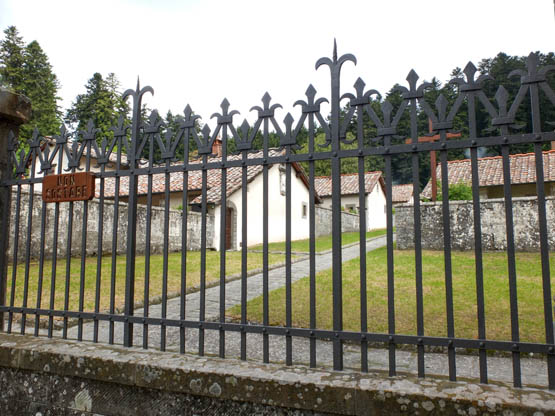
At the heart of the National Park is the vast Camaldoli forest, bequeathed in 1012 to a community of monks who tended it for over eight centuries, a task now carried out admirably by the Park. The name is believed to derive from campo amabili (pleasant field), although nowadays both the parent monastery and the isolated Eremo are set under towering trees. The monks are still to be found at Camaldoli, where they run a pharmacy (www.camaldoli.it). Walk 15 starts here.
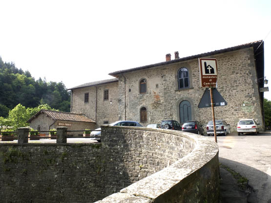
The entrance to Camaldoli and the monastery (Walk 15)
Easily recognisable from afar, the massive incline of Monte Penna rises above the woods at the southernmost tip of the Casentino. Geologists have described the outcrop as a raft of limestone afloat on a bed of clay, but it boasts quite a few claims to fame in terms of art and history: it has been suggested that the great Renaissance artist Michelangelo – whose childhood years were spent at nearby Chiusi della Verna – depicted Monte Penna as the ‘seat’ for Adam in the famous Sistine Chapel ceiling fresco. The mountain is also home to La Verna, yet another landmark sanctuary. Walk 16 explores the forest then summits neighbouring Monte Penna.
Well below, and south of the regional capital Arezzo, is the lovely hill town of Cortona, which leaves long-lasting impressions including wonderful views over the broad Val di Chiana and Lago Trasimeno. Cortona became a powerful Etruscan city state during the 8th–4th centuries BC before entering into an alliance with Rome, and its ancient name Curtun has survived all but intact. Stretches of defensive walling made of huge rectangular stone blocks were to little avail when Hannibal’s troops laid waste to the city in 217BC, having overwhelmed Roman forces on the shores of nearby Lago Trasimeno. ‘The most sturdily ancient of Italian towns’ (according to Henry James), Cortona is quintessentially Tuscan, and virtually every hotel room looks over the characteristic jumble of red-tiled roofs. In a blend of medieval and Renaissance architecture, the buildings seem to cascade down the hillside, with surprisingly steep narrow streets and flights of steps threading through the maze. Not a town for the weak-kneed! Walk 17 sets out from the town centre for a ramble in the footsteps of St Francis to the beautiful Franciscan retreat of Le Celle dating from the early 13th century; its guests have included such renowned figures as St Anthony of Padua.
For the Pratomagno, Saltino is close to Vallombrosa and has both accommodation and buses from the railway stations at Pontassieve and Florence.
For the Foreste Casentinesi, Rifugio Città di Forlì provides accommodation in the north, as does Camaldoli, while further south is well-served Chiusi della Verna. Both Camaldoli and Chiusi della Verna have buses from Bibbiena on the Arezzo–Stia train line.
Cortona is a short bus trip from trains at Camucia and offers a vast range of accommodation.
| Start/Finish | Saltino |
| Distance | 12km |
| Ascent/Descent | 600m |
| Grade | 2–3 |
| Walking time | 4hr 15min |
| Map | Biogenetic Nature Reserve of Vallombrosa map |
| Access | AMV buses from Florence via Pontassieve (railway station) come up to Vallombrosa and Saltino. |
The Vallombrosa Reserve lends itself to this excellent varied walk. Gentle climbs lead to a panoramic crest overlooking Valdarno – and all the way to Florence – before a traverse to the main scenic Pratomagno ridge. Afterwards, a rather steep path dodges immensely tall pine trees on its plunge to the historic monastery, so trekking boots are recommended. A shortcut is given below, reducing the walking time by about half an hour.
As regards facilities, Saltino has shops, then there’s a café/restaurant at Secchieta and others along the Vallombrosa–Saltino road, but it’s best to be self-sufficient with food and water. Don’t forget to pick up the walking map locally. Should you fancy a night out in the forest, kit yourself out with sleeping bag and food and stay at Capanna delle Guardie.
Leave Saltino (1000m) on the road in the direction of Vallombrosa. About 10min later (just before a restaurant and Fonte di Santa Caterina), branch sharp R up a lane signed n.12 Secchieta–Macinaia. This heads steadily SW uphill beneath tall straight conifers. At a fork with n.12A, keep L past a traffic barrier, soon curving SE. At the next signed fork, go R on n.11 to quickly reach a wooded ridge and a broad forestry track, where you branch L on n.13, resuming the SE direction. This wastes no time ascending steeply through beech woods then alongside fields with marvellous views over Valdarno. Ignore turn-offs and follow the red-and-white waymarks.
After a hunters’ hut on Poggio alle Ghirlande (1200m), the way narrows to a path in ascent E around Monte Cuccuruzzo (1326m) and enters the Foresta di Sant’Antonio. A broad lane is joined (n.12) and you stick with this to the houses at Macinaia junction (1314m, 1hr 30min), where a shortcut is feasible.
The lane (n.12) leads NE straight through to the ridge where you pick up the main route near Monte Secchieta.
From Macinaia junction, go R past picnic tables, a map board and a traffic barrier. Down at the first bend in the lane, leave it for path n.14 signed for Capanna delle Guardie (not to be confused with Case Sant’Antonio). This leads through stunning beech forest and around rock outcrops in the company of scented Mediterranean flowers and laburnum, with several ups and downs and past old clearings used by charcoal burners. You emerge from the woods at a belvedere over Valle di Sant’Antonio, then you reach the Capanna delle Guardie (1340m, 30min).
Now take path n.R4 climbing quickly due N to a picnic area (1437m), in sight and earshot of three giant wind turbines. A lane leads to an open crest smothered with broom, where you turn L (NW) on a wide lane below a clutch of antennas. This is the main Pratomagno ridge with brilliant views both sides, over Valdarno and to the Apennines.
After two houses, a surfaced road is joined N and you soon pass the junction where the shortcut from Macinaia comes in. Not far along is Bar Giuntini (1420m, 45min) at the foot of Monte Secchieta. On the opposite side of the road from the café, near a bus stop, path n.9 begins its plunge W through the forest. Watch your step and follow the waymarks on tree trunks scrupulously.
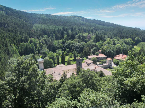
Bird’s-eye view over the Vallombrosa monastery
At a minor road is a cool spring and a building, aptly called Paradisino, where John Milton stayed.
At Paradisino, take time to visit the terrace at the rear of the building for a bird’s-eye view over the Vallombrosa monastery. ‘Thick as autumnal leaves that strow the brooks in Vallombrosa…’ (Paradise Lost, 1667) – so wrote the great English poet John Milton, who found inspiration here during his 1636 sojourn.
Path n.9 continues downhill as a stepped paved way, passing chapels, concluding at the fish-breeding pond and buildings of Vallombrosa (1000m, 1hr). After visiting, retrace your steps, turn L and follow the road back to Saltino (30min).
| Start/Finish | Car park for Rifugio Città di Forlì |
| Distance | 13km |
| Ascent/Descent | 650m |
| Grade | 2 |
| Walking time | 4hr 40min |
| Map | SELCA Parco Nazionale delle Foreste Casentinesi 1:25,000 |
| Access | Public transport is limited to an ATR summer bus from Forlì to Passo della Calla. Otherwise drive to Passo della Calla and turn NW for 2km to La Burraia, then L up a dirt road to the car park for Rifugio Città di Forlì. |
An excellent day out in magnificent surroundings, this superb walk starts at La Burraia, an important high-altitude Apennine pasture. Worked until the 1950s, it was renowned for its rich milk and butter, hence its name. It is also the location for the stunningly positioned Rifugio Città di Forlì. This welcoming refuge is a boon for walkers as it offers meals, refreshments and overnight stays all year round.
Accompanied by plentiful bird life and floral rarities, the walk visits two modest but panoramic mountains overlooking Emilia-Romagna and Tuscany, before dropping to the source of the River Arno. Soon afterwards is a pond, alias Lago degli Idoli, so named because of the discovery of a remarkable quantity of Etruscan treasures beneath its waters.
The route is easily shortened by limiting it to Monte Falco (2hr 20min return) or Monte Falterona (3hr 20min return).

Rifugio Città di Forlì occupies a lovely position in open meadows
From the car park (1388m), walk up the dirt road S towards Rifugio Città di Forlì (1437m, 10min), set in the magnificent meadows of La Burraia at the foot of Monte Gabrendo. Unless you’re yearning for a coffee, skip the refuge for the time being and continue uphill to join wide path n.00. Follow it R (NW) towards the crest to enter a natural corridor through beech woods. You’re led along a scenic ridge among springy mountain pines alive with birdsong. Detour a cluster of aerials and pass a ski lift, then keep L at a fork through a flower-covered nature reserve to Monte Falco (1657m, 1hr).
Fork L initially abruptly downhill on a clear path WSW. Some way on, after a rise, you descend to a fork (go R) to climb out to another brilliant lookout not far from a large cross marking Monte Falterona (1654m, 30min).
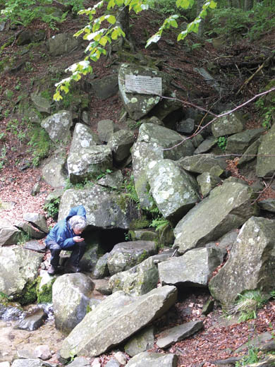
Now you need path n.3, which plunges due S to an intersection – veer R (W) down through dense woods to Capo d’Arno (1358m, 30min), where the infant River Arno springs from rock. Take the path that wanders initially S for a gentle uphill to a fenced pond, Lago degli Idoli (1368m).
Originally called ‘lake of the cherry trees’, Lago degli Idoli was renamed after the 1838 discovery of over 700 bronze Etruscan statuettes, coins and votive objects. These were cast into the lake as an offering by the Etruscans, who believed the water to have healing properties.
Walk past the signboard and hut (handy for emergency shelter) onto a lane SE. At a junction, fork L (N) on path CT4, following a fence uphill through open fields and beech woods. Back up at the intersection (1hr 10min) where you forked down to Capo d’Arno earlier, veer R (NNE) beneath Monte Falterona now. It’s steady uphill for the return to Monte Falco (30min). Retrace your steps to Rifugio Città di Forlì (40min) and then descend to the car park (10min).
The source of the River Arno
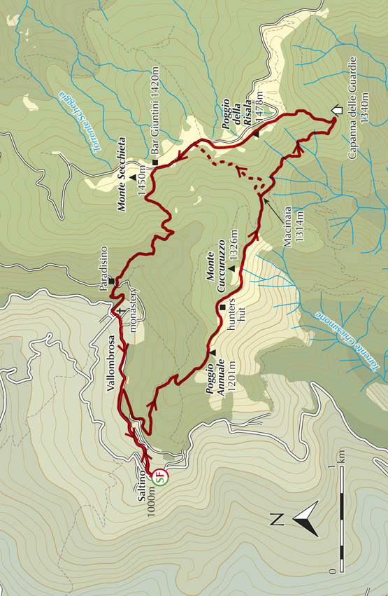
| Start/Finish | Camaldoli |
| Distance | 7.5km |
| Ascent/Descent | 480m |
| Grade | 1–2 |
| Walking time | 2hr 40min |
| Map | SELCA Parco Nazionale delle Foreste Casentinesi 1:25,000 |
| Access | Year-round Etruria Mobilità buses link Camaldoli with Bibbiena railway station on the Arezzo–Stia line. A summer service also extends to the Eremo. |
This easy loop boasts multiple points of interest, including the Camaldoli monastery, the Eremo retreat, roadside shrines and the magnificent forest itself with its wealth of plant and animal life. Camaldoli also has a fascinating 15th-century pharmacy, a National Park Visitor Centre with an ornithology museum, and hotel/restaurants. Don’t miss the café which serves up a delicious schiacciata, a soft pizza pocket with your own choice of filling, made on the spot.
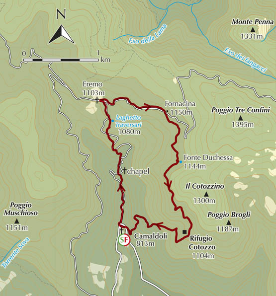
From the monastery at Camaldoli (813m), take the minor surfaced road N past the National Park Visitor Centre. Not far along is a Madonna della Neve shrine, followed by a bridge. Walkers soon need to branch R on the old paved way, which is surprisingly broad. This climbs gently to cross the tarmac near a chapel.
The chapel houses a stone bearing an imprint of San Romualdo, founder of the Camaldoli order. According to legend, he was at prayer when the devil pushed and shoved him in an attempt to draw him into terrible temptation!
Now, on the L of the road, a red-and-white marked path climbs alongside cascading streams. Not far up, don’t miss the fork L over a stream, continuing on steep zigzags that cut a corner of the road. Keep following red-and-white markers up to the tarmac and past a trio of crosses. Not far up is Laghetto Traversari (1080m), a small man-made lake. Now a nature reserve, it was excavated in the 1400s for breeding fish and eels (the monks didn’t eat meat). Not far on, you join the road for the final metres to the peaceful setting of the 12th-century Eremo (1103m, 1hr).
The monks’ bungalow-cells at Eremo di Camaldoli
Take the minor road due E signed for Prato alla Penna, aka walkers’ route n.70. You stick with it until Fornacina (1150m), where a forestry lane forks off R. This leads gently uphill bearing S and on to a spring, Fonte Duchessa (1144m). Once over a rise, you cut across remarkably steep mountainsides, occasionally glimpsing the valley below. In a tiny clearing alive with birdsong stands the forestry hut Rifugio Cotozzo (1104m, 1hr).
Fork R (SW at first) on an old well-graded way scattered with pine cones. Watch your step on the loose stones and the occasional toppled tree for the straightforward descent back to Camaldoli (40min).
| Start/Finish | Chiusi della Verna |
| Distance | 6.6km |
| Ascent/Descent | 330m |
| Grade | 1–2 |
| Walking time | 2hr 15min |
| Map | SELCA Parco Nazionale delle Foreste Casentinesi 1:25,000 |
| Access | Year-round Etruria Mobilità buses link Chiusi della Verna with Bibbiena on the Arezzo train line. In summer the bus extends to La Verna. |
| Note | The descent path can be slippery due to fallen leaves. |
This ramble links the hospitable village of Chiusi della Verna with La Verna sanctuary and Monte Penna on a loop route. La Verna has a café/restaurant, as does the walk start, where there are also grocery shops. The walk itself is straightforward, although with some steady climbing, and culminates at a superb lookout.
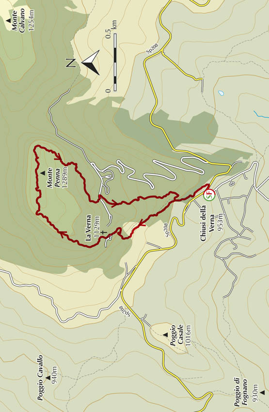
From the bus stop near the Carabinieri (police station) at Chiusi della Verna (953m), walk SE along the road past a bank to Hotel da Giovanna. Here is the signed start of the old paved access lane (n.51) that strikes out NNW to La Verna sanctuary. Leaving the buildings behind you, amble uphill entering lush woodland featuring colossal Turkey oak trees. Where n.51 forks R (the return route), ignore it and keep straight on (n.50/GEA). Further up you branch R onto a wider paved lane and continue in ascent to the pilgrims’ entrance to La Verna sanctuary (1129m, 35min).
Founded in 1012, La Verna is one of the many places that hosted St Francis on his extensive wanderings through central Italy. Tradition has it that he received his stigmata here on September 14, 1224.

An ancient paved way climbs towards La Verna
Turn L through the arched gateway and up the steps for the panoramic square. Walk past the church and turn sharp R out through doors. Immediately L now take the flight of steep stone steps climbing above the sanctuary into the cover of trees. You pass through magnificent beech woods interspersed with yew, a glorious colour contrast in spring and autumn. Carefully follow the red-and-white waymarks on trees as the path curves L, passing two tiny stone huts. The way soon moves N along the edge of the mountainous slab, via a sequence of notched saddles and sheer drops that are wisely fenced off. You reach a chapel on the highest point of Monte Penna (1289m, 40min), along with a belvedere giving an absolutely fantastic outlook over the surrounding rolling hills and farmland of Emilia-Romagna.

The walled sanctuary of La Verna
Continue on the marked path, which proceeds briefly E, soon to begin the descent SW. You pass through mixed woodland on paths and lanes, approaching the buildings of La Verna (30min) from the opposite side this time. Unless you wish to re-enter the premises, go L away from the buildings and out through the gates past a statue of St Francis.
Continue along the narrow road, and soon after the first bend branch off R for the Sentiero Natura/n.51. This plunges S in the silent leaf-strewn valley of Fondo della Melosa, among moss-covered boulders and towering beech trees. Further down, after a passage through a jumble of rocks, you pass the entrance to the Oasi di San Francesco and soon rejoin the paved lane followed on the way out. Turn L to return to Chiusi della Verna (30min).
| Start/Finish | Piazza della Repubblica |
| Distance | 12km |
| Ascent/Descent | 500m |
| Grade | 2 |
| Walking time | 3hr 45min |
| Map | SELCA Sentiero 50 dal Trasimeno alla Verna 1:50,000 |
| Access | From Camucia railway station, catch the Tiemme bus up to Cortona. From the bus stop in Piazza Garibaldi, walk along Via Nazionale to the main square, Piazza della Repubblica. |
The itinerary described here is a kaleidoscope of history and nature. After climbing through Cortona, accompanied by cawing jackdaws, acrobatic swallows and the perfume of stately lime trees, it follows an old paved way through woods and extraordinary explosions of wildflowers to a panoramic ridge. It is believed that St Francis used this route, and the ensuing descent takes in a perfect Franciscan retreat.
The paths are easy to follow, although waymarking is patchy and the area is criss-crossed by forestry and hunters’ tracks, so follow directions carefully. A fair climb is involved but the steepest sections are in the town itself! Late spring is best for wildflowers – rock roses, tree heather and masses of broom.
Walkers need to carry picnic supplies and water as there are no eateries beyond Santa Margherita and Torreone. Tasty suggestions include the local loaves ciaccia con ciccia (pronounced ‘chacha con cheecha’), flavoured with a sort of bacon, or ciaccia con formaggio, with cheese.
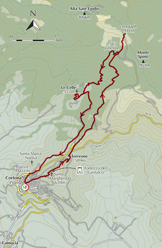
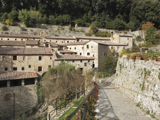
The idyllic Franciscan retreat of Le Celle
From Cortona’s Piazza della Repubblica (494m), it is naturally an uphill route on Via Santucci, behind the supermarket. The broad pedestrian-only lane climbs stiffly through a covered passage to emerge at the Chiesa di San Francesco. Keep on puffing up Via Berrettini to pass a huge old circular well in Piazza del Pozzo. At triangular Piazza Pescaia, keep L up past the church of San Cristoforo, then R onto Via Santa Croce. This paved lane lined with cypresses winds up to the church of Santa Margherita (620m).
Head out on the road through the old walls, their cracks overflowing with perfumed golden wallflowers. The Alta Sant’Egidio mountain looms to the north. Red-and-white waymarking for n.561 is soon evident, and you are pointed to the tree-bordered avenue to the R of the road. There’s a level stretch then broad curves downhill with wide-ranging views over the wild hills, including Monte Cuculo to the north-east. As you reach the asphalt, veer R to Torreone (589m, 30min), where there’s a restaurant/snack bar.
Straight across the road, n.561 continues NNE past a tiny church. Scattered properties are passed on the gradual ascent. Stick to the red-and-white marked lane, which further on reverts to its previous rough state as it enters thick chestnut woods. Half an hour from Torreone will see you at a stream where n.561 forks off R, the start of the delightful flagged way. With a perfectly calculated gradient, it winds up into a peaceful woodland of tall dark firs, where the drumming of woodpeckers echoes. After a second minor watercourse, it crosses open moor-like terrain, home to a host of wild orchids and aromatic herbs.
At the n.563 junction (needed for the descent), a dirt track is crossed. Keep straight ahead through the final stretch of chestnut woods to open terrain and overgrown terracing. Enjoying vast views over the Val di Chiana and back to Cortona, you emerge onto a quiet surfaced road opposite a cenotaph and pine copse, which conceals a pleasant shady picnic area (911m, 1hr 15min).
Return the same way to the n.563 junction and the dirt track, and turn R. After a couple of bends downhill, branch L onto a rougher track through beautiful chestnut and oak woods, and very soon go L again on a path. Further down, a group of largish pine trees heralds a red-and-white marked turn R. Path n.561 descends, plunging at times as a sunken narrow way. A minor power line criss-crosses the way as you wind through Mediterranean shrubs and trees, finally coming out at properties, one with a swimming pool.
Keep down on the narrow access road, then turn R as you meet the surfaced road from Torreone. Close at hand is the picturesque group of light-coloured stone buildings that make up the idyllic Franciscan retreat of Le Celle (553m, 45min).
Walk through the gates and down across the stone bridge over Fosso Pontoni to the visitors’ entrance. After checking out the saint’s spartan cell, go L up to the church. Then go straight ahead for a ramp and sharp L to recross the stream on another elegant bridge. The path leads back up to the car park at Le Celle entrance (15min).
Now take the minor road S in the direction of Torreone. About 2km along, before reaching the road back to Cortona, fork R on an unsurfaced road heading SW with great views to Cortona. Descending a little, it passes the odd house and coasts above the monumental church of Santa Maria Nuova before emerging on the road. Only metres away to the R is Piazza Mazzini, with a car park and massive Etruscan walls. Turn L through the huge gateway into the old town on Via Dardano to the Croce del Travaglio crossroads. Keep R into Piazza Signorelli (Tourist Office and Museo dell’Accademia Etrusca), then L for adjoining Piazza della Repubblica, where you started (1hr).