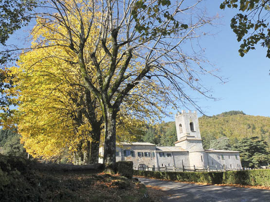
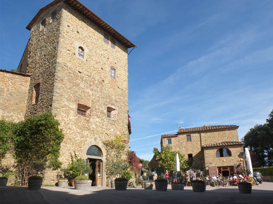
The elegant abbey of Badia a Coltibuono in autumn (Walk 18)
The elegant abbey of Badia a Coltibuono in autumn (Walk 18)
In addition to wine, the name Chianti evokes gently rolling hills patterned with well-loved vineyards alongside olive groves. Located between Florence and Siena, this beautifully photogenic district is dotted with charming hill towns and riddled with meandering rivers and narrow roads lined with cypress trees, yellow broom and oak woods. Things were not always so peaceful. The region has a tormented past, as it was fiercely contested by the two powerful cities from the Middle Ages through to the Renaissance – this goes to explain the many castles, towers and fortified settlements. Back in the late 1300s, Florence grouped together Radda, Gaiole and Castellina and founded the Chianti League as a buffer against its enemy Siena. A black rooster was adopted as their symbol – and the same symbol is now used for the wine. Nowadays, peace and well-being reign, thanks largely to wine production along with tourism.
Of the hill towns, picturesque and quiet except when animated by market days, laid-back Gaiole in Chianti is located on a river in rural surroundings and was a key trade centre for the League towns; it is the start for Walk 18. Castellina in Chianti boasts Etruscan origins and elegant medieval buildings; Walk 19 begins here and ends in pretty Radda in Chianti, atop a knoll surveying the glorious rolling hills – this is arguably the most attractive of the hill towns and is a perfect base for exploring the region. The tiny historic town centre is both fascinating and quiet, with a camminamento medievale (medieval walkway) and, in the square, its Palazzo Comunale whose facade is set with ceramic shields. Walk 20 explores the countryside around the nearby medieval village of Volpaia, while Walk 21 loops out from Poggio San Polo, not far away. More routes are feasible – enquire at the local tourist offices. All the towns are well served by bus, and facilities are excellent.
Radda in Chianti is an excellent base and has good bus links with Siena, together with accommodation options. Castellina in Chianti comes in second best with similar facilities.
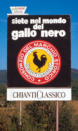
The gallo nero (black rooster) of Chianti Classico
Chianti is synonymous with red wine – associated not only with the straw-covered flasks that are famous the world over but also with quality Chianti Classico and its distinctive gallo nero (black rooster) label. Wine has been made here since Etruscan times, and the name very likely derives from an Etruscan inscription ‘Clunti’. Back in 1716, Cosimo III, Grand Duke of Tuscany, introduced the first geographical boundaries for Chianti wine, although these have since been enlarged. Another key year was 1874, when winemaker Bettino Ricasoli defined the recipe: 80 per cent Sangiovese grapes and 20 per cent other varieties such as Malvasia and Trebbiano. The precious liquid has long been appreciated. Giuseppe Verdi sojourned here in the late 1800s; in his wife’s words: ‘Verdi is fine, he eats, runs about the garden, sleeps and drinks Chianti’.
A visit to a wine estate for a tasting is a highlight of any visit to the Chianti region.
| Start/Finish | Gaiole in Chianti |
| Distance | 13.5km |
| Ascent/Descent | 320m |
| Grade | 2 |
| Walking time | 3hr 30min |
| Map | Kompass n.2440 Toscana 1:50,000 map 2 |
| Access | Gaiole in Chianti has a good Tiemme bus service from Siena, as well as direct ACV links with Florence. |
| Note | Waymarking is patchy so follow the route directions carefully. |
This excellent circuit begins at the lovely town of Gaiole in Chianti, but the day’s highlight is the beautiful Benedictine abbey, Badia a Coltibuono.
The walk initially alternates woodland with vineyards, then follows a scenic ridge before dropping back to Gaiole. Take a picnic lunch. If you count on eating at the Coltibuono restaurant (not conducive to walking!), then park there and use it as the walk start/finish.

From the bus stop, walk past the big black rooster and into the square of Gaiole in Chianti (360m). The town is spread along broad pedestrian Via B Ricasoli. Follow this N past cafés and shops to the Coop supermarket. Take the next R, Via Baccio Bandinelli da Gaiole, uphill following red-and-white markers on poles. Not far up, branch L, signed for Riecine. The narrow surfaced road, also known as the Strada Vecchia di Masseto, climbs quickly, leaving the town behind and overlooking rolling countryside planted with grapes and olives.
Further up, the way is unsurfaced, bearing N through oak woodland then past the Riecine wine estate. Over a rise past an abandoned house, the lane curves NE alongside a stream shaded by poplars before emerging at the roadside. Turn R with care to the nearby intersection and another huge black rooster. Follow signs past a shop and car park up to the tranquillity of Badia a Coltibuono (627m, 1hr 20min) and restaurant.
The elegant Badia a Coltibuono stands facing east, looking over Val d’Arno to the Apennines. The monastery dates back to the 8th century, while the fine Romanesque abbey church was built in 1050. It is now part of a wine estate, whose cellars and formal gardens can be visited (www.coltibuono.com).
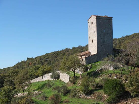
The old fortified tower-cum-house of Cancelli
Backtrack to the rooster at the intersection and cross straight over (S) past the photogenic tower-cum-house of Cancelli. Proceed uphill past an abandoned quarry below modest Monte Grossi, and onwards with views over the Chianti countryside to far-off Radda as well as Gaiole below. At the peaceful hamlet of Montegrossi (642m, 20min), a lane takes over ENE. Keep L on n.00 at the first fork and, soon after, ignore the entrance to Podere Montelucci. Along a broad scenic ridge, the way widens and follows wire fencing. At the edge of a dark conifer plantation, fork R off the main lane and up a rutted way S, guided by red-and-white markings on trees and passing a small madonna shrine (Poggio Barbari). You coast through broom and towering pines, oak and chestnut, before descending in earnest on rocky terrain.
Down at a wide lane, branch R for a couple of bends downhill before another fork R. Further down are views across vineyards to the fortified hamlet of Barbischio. You swing briefly N to a river crossing, keep L past a renovated mill and join a minor surfaced road that leads W back to where you began at Gaiole (1hr 50min).
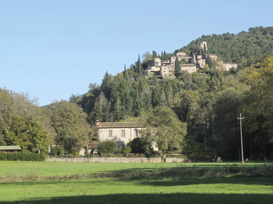
Barbischio comes into view on its perch
| Start | Castellina in Chianti |
| Finish | Radda in Chianti |
| Distance | 16km |
| Ascent | 340m |
| Descent | 390m |
| Grade | 1–2 |
| Walking time | 4hr |
| Map | Kompass n.2440 Toscana 1:50,000 map 2 |
| Access | Tiemme buses regularly link the two towns with Siena, while Radda has direct ACV buses to Florence. It’s logical to start out from Radda on the handy morning bus to Castellina, then you don’t have to worry about arriving on time for a return bus. |
The two attractive medieval hill towns of Castellina and Radda are joined by this delightful wander through vineyards, olive groves and countryside bright with wildflowers in spring and awaft with sweet-scented aromatic herbs in summer. Isolated farms are set back off the road among light oak woods. You walk on undulating lanes and paths, with the odd brief stretch of dusty unsealed road.
Take food and drink as there are no refreshments until Radda. The walk can be shortened a little (to about 3hr 20min) by taking the direct route to Radda (described below) on the last leg of the main route.
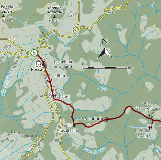

From the bus stop in Piazza Roma at Castellina in Chianti (580m), follow signs for centro SE along Via Trento e Trieste past shops, traversing the township. At the lovely church, branch R up Via Rocca to the magnificent towering Rocca (Museo Archeologico) in the main square. Alongside Trattoria La Torre, keep L down a ramp then R to leave the old centre and pedestrian area. Walk straight ahead past the Carabinieri (police station) and out to join the main road, then continue past an intersection near silos. Not far on Via dei Castagni forks L (E) at a chapel. Past houses it quickly becomes a dirt road through fields and oak woods. A short climb brings you to a fork – go R past a small vineyard then R again, winding down to join a wide unsurfaced road near the entrance to Villa Casalecchi (30min).
Turn L here (E) and on through the tiny hamlet of Mandorlo, with gentle ups and downs past cultivated properties. A cypress-lined stretch leads to the entrance to Villa Capovento and the turn-off for Badiola (571m).
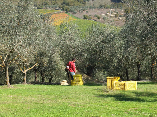
Harvesting the olives at Pornano
Back on the main way, the panorama is peacefully pretty, with continual sweeping views that take in traditional houses scattered through the woods, and the occasional clearing for olives or grapes. The unsurfaced road starts a long winding descent past the entrance to the Brancaia winery before flanking the thriving olives and vines belonging to the Pornano estate. Keep on down through scented broom to the large shed at the 368m intersection (1hr 20min). Here, the dirt road for Radda bears R (SE) but walkers can cut the corner. Go down L (N), ignoring turn-offs for properties, to cross the concrete bridge over Torrente Arbia. Take the next turn-off R (while the track you’ve left continues to Poci). The old way climbs out through the fields belonging to the isolated house of Petrene, then follows its access lane, dropping down to join the unsurfaced road once more. Go L (N) alongside the Fosso delle Filicaie stream, shaded by willows. In a little over 2km you curve E past the Poggio Petroio estate to a road junction (50min).
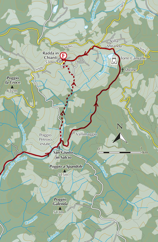
Turn L along the road and ignore the turn-off for Vallimaggio (the main route). Continue uphill to the next fork R, a quiet shady lane that follows a stream N. At a bridge near pillars for a property entrance, keep L (without crossing the stream), starting a steady climb. Further up, as you reach playing fields, the lane is surfaced. At a church, keep L up the road below the township now. As the road curves, fork R past a car park and the restaurant La Loggia del Chianti. Soon, steps lead up to the road and the bus stop at Radda in Chianti (530m, 40min).
Turn L along the tarmac in the direction of Radda, but keep an eye out for the first lane R, signposted for Vallimaggio. It climbs quickly, and you keep L at the estate driveway, circling NE below the main homestead. Soon after, ignore the fork R for Capannole. Further on is a curious wayside shrine, where three cypresses are the backdrop for a round stone base topped by a cross.
Only minutes away, near houses, leave the lane for the clear path straight ahead, in the company of yellow poles for the gasdotto (gas pipeline). After descent through woods, you join a lane, keeping R downhill past the picturesque tower-cum-house Torre Canvalle. There’s a dip across the bottom of the valley then it’s up to tarmac.
Go L along the main road past Villa Miranda but at the nearby intersection drop L onto a farm track heading uphill (W) between rows of grapevines and the road. At a house, ignore the lower lane for Le Vigne and take the upper way to skirt around the back of the building, where a track resumes below the road and a stone wall. At the next property, you join the road for the final short leg up to Radda in Chianti (530m, 1hr 20min).

The Torre Canvalle can be seen beyond vineyards on the last leg
| Start/Finish | Volpaia |
| Distance | 6.3km |
| Ascent/Descent | 300m |
| Grade | 2 |
| Walking time | 2hr |
| Map | Kompass n.2440 Toscana 1:50,000 map 2 |
| Access | Volpaia, alas, has no bus service; it’s a short drive or taxi ride N from Radda in Chianti. By car, the walk can also be accessed from Santa Maria Novella or Castelvecchi. |
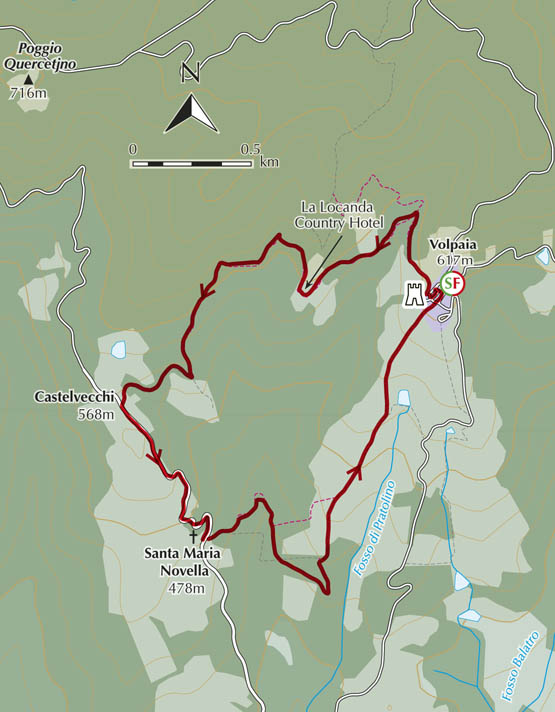
With narrow alleys lined by well-preserved stone buildings, Volpaia is one of those delightful medieval villages in the Chianti district that seem oblivious to the hectic rhythms of the 21st century. As well as occupying a first-rate panoramic position, it has laid-back trattorias that serve delicious homestyle Tuscan lunches in a small square in the shade of the 13th-century castello, a reminder of a long military history.
This rewarding circular itinerary takes in Volpaia’s historic buildings before following country lanes and paths towards the Romanesque church of Santa Maria Novella. There is little waymarking so directions need to be followed carefully. Rolling expanses of fields and vineyards accompany walkers, but surprisingly also many tracts of woods which shelter fallow deer and foxes – volpe in Italian, as in the name Volpaia.
The walk starts in the main square of Volpaia
From Volpaia (617m) and its main square, facing the elegant castle tower, go L into nearby Piazza della Cisterna. Turn past the well and keep R at the church onto a rough lane. In gentle descent this heads N past olive trees. At a cross (hiding behind a cypress tree!), keep R down into chestnut woods. At a fork where a boulder bears faded directions, curve L down to cross a bridged stream. Up the other side you emerge from woodland at a vineyard.
At the top, the lane goes R past buildings belonging to La Locanda Country Hotel, aka Casa Montanino. From the car park, you’re pointed L onto a path (signed for Castelvecchi) into a clearing – keep R. The narrow overgrown path soon crosses a stream and begins a gentle climb N through rock roses and tree heather. There are several minor changes of direction, but the way bears SW for the most part. Further along, as you reach a vineyard and unsurfaced road, fork R up to the tarmac and the fortified village of Castelvecchi (568m, 1hr), with its wine cellars and restaurant.
A stroll downhill on the road is Santa Maria Novella (478m, 15min), a graceful 12th-century Romanesque church. Opposite the building, turn L and take the clear grassy lane, which quickly becomes a rough stony path plunging NE. Two stone bridges cross minor streams then the path climbs SSE, the undergrowth brightened by cyclamens. Ignore turn-offs. The way widens, bearing E above vines to a T-junction where you veer sharp L, as indicated by a painted stone marker.
Following signs for Volpaia, continue N through woods, vineyards and past houses, before bearing L for a steepish climb. This passes a shrine at the start of cypress-lined Viale del Nonno (Grandad’s Avenue) – a grandiose approach to Volpaia (45min).
| Start/Finish | Poggio San Polo |
| Distance | 5.5km |
| Ascent/Descent | 220m |
| Grade | 1–2 |
| Walking time | 1hr 30min |
| Map | Kompass n.2440 Toscana 1:50,000 map 2 |
| Access | Occasional Tiemme buses link Poggio San Polo with Gaiole in Chianti. |
This pleasant loop is one of the few fully waymarked walks in Tuscany, offering straightforward walking on paths and lanes through quintessential Chianti countryside studded with cypress trees, vineyards and olive groves. It passes a number of working rural properties, sometimes leading through woodland.
The tiny hamlet of Poggio San Polo boasts a well-loved wayside chapel, a cluster of old stone houses, benches and drinking water. There are no refreshment places en route.
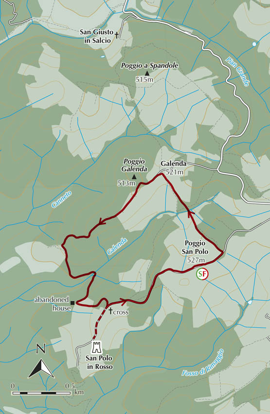
From the bus stop and car park on the eastern edge of Poggio San Polo (527m), walk NE along the road. A kilometre from the hamlet, leave the tarmac L (NW) for a red-and-white waymarked lane (10B) into fields of olives – a beautiful open stretch with views back to Poggio San Polo over the cultivated hillsides. Walk downhill along the edge of a field to a gate (R) leading along fenced vines to cross a stream at a concrete acquedotto hut. The clear path leads up into light woodland then through an arched passageway into Galenda (521m, 30min). The simple stone houses here have mostly been converted to tourist accommodation.
Beyond the houses, turn L (red-and-white marks) for a gentle climb SW on a lane that reaches old terracing and low stone-walling. After a hunters’ hide, it begins to descend into oak woods, passing a low rock barrier (evidently to stop vehicles). Down at an abandoned house, veer L in steady descent to cross a stream. It’s not far up to a curious wooden cross atop a huge rock base, at an unsurfaced road along a gloriously open ridge.
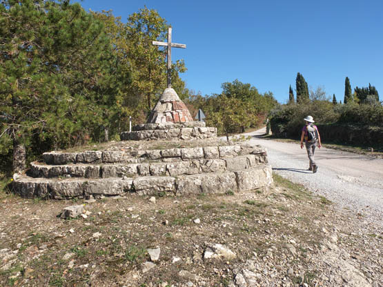
A curious wooden cross is encountered on an unsurfaced road
Turning R is a short detour to the castle-cum-church and wine estate of San Polo in Rosso, but you go L uphill past a cemetery and along an avenue of cypresses to the tarmac at Poggio San Polo (1hr).