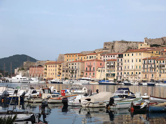
The waterfront at Portoferraio (the main port on the island of Elba) backed by the fortress
The waterfront at Portoferraio (the main port on the island of Elba) backed by the fortress
A popular legend recounts that as Venus rose from the sea, her girdle shattered into jewelled fragments, becoming the splendid island of Elba and its neighbours. At a later mythological date Jason and the Argonauts dropped by during their quest for the Golden Fleece.
Elba is the third largest island in Italy, after Sicily and Sardinia, one of seven in the Parco Nazionale dell’Arcipelago Toscano (www.islepark.it). Shaped like a huge fish with oversized fins, it is 27km long, 18km wide and boasts 147km of coastline edged by aquamarine waters. The island belongs to a submerged mountain chain of volcanic ancestry, which means fertile earth, lush vegetation and thriving agriculture, with olives and grapevines producing memorable wines. However, as far back as 3000BC a long string of colonisers were attracted by the island’s promising mineral wealth. The ancient Greeks knew Elba as Aithalia (‘smoky’, because of the Etruscan smelting works) and the ancient Romans called it Ilva (meaning ‘iron’); key place names have lived on – Portoferraio (Iron Port) and Monte Calamita (Mount Magnet).
Elba was later colonised by the Pisans, Medici and the Spanish, not to mention the French, who annexed it. More often than not, Elba is associated with Napoleon Bonaparte’s brief period of enforced sojourn there in 1814–15 as nominal emperor, prior to his Hundred Days and the defeat at Waterloo.
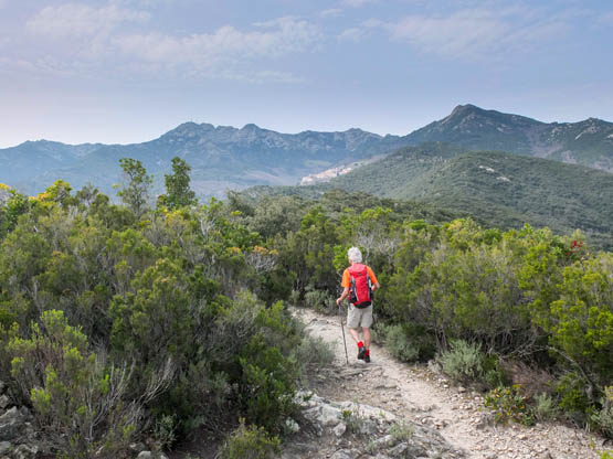
There are many good reasons to take the ferry over from the ‘continent’, as the islanders call it. (The ferry port is at Piombino Marittima, reachable by train via Campiglia Marittima on the Livorno–Rome line.) Walkers can ramble to their heart’s content in the rugged mountainous interior honeycombed with goat tracks. Age-old chestnut woods alternate with abandoned terracing where vines are being outgrown by wild herbs, and paths high above the turquoise sea lead through veritable botanical gardens ablaze in spring with the colours and scents of the Mediterranean maquis.
Walks 33–36 explore different corners of Elba. Trekkers will enjoy the long-distance Grande Traversata Elbana (GTE, or Great Elban Traverse), which crosses the island in four stages.
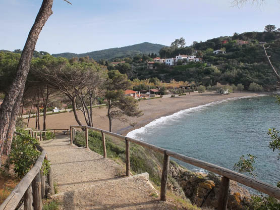
Most visitors travel straight through the central section of Tuscany’s Tyrrhenian coast heading for the Elba ferries, and hardly notice the attractive hills and villages. Yet the area has plenty to interest both walkers and archaeology buffs. The splendid sweep of the Golfo di Baratti is lined by a wonderful beach backed by magnificent umbrella pines, its western extremity dominated by a headland where the turrets of Populonia are silhouetted at sunset.
Around the 3rd century BC, depleted timber and water supplies and increased pirate attacks on Elba saw smelting work shifted to the Etruscan city state of Pupluna on the mainland, a judicious move. However, over time, slag mounted up to a height of 20m, and the sites were abandoned. It was not until the 1930s, when a Piombino mining company realised that modern methods could extract a lot more iron from the scoriae, that a monumental ancient Etruscan necropolis saw the light of day. Many tombs had caved in, but thanks to extensive restoration they can now be appreciated in the Parco Archeologico di Baratti e Populonia. The most impressive are circular tumuli with inner chambers reached via back-breaking passageways. One of the oldest (7th century BC) is the 28m-diameter Tomba dei Carri, where a patrician family was interred with two ritual chariots. Walk 37 sets out from Baratti and explores both the necropolis site and the wild wooded headland. As visitors can gather from the numbers of hunters who tramp through in late autumn, it provides refuge for wildlife ranging from red and fallow deer to pheasants and wild boar.
A tad inland and a short drive or bus trip away is Campiglia Marittima and little-visited Val di Cornia, with rolling hill terrain and lovely coastal views. Walk 38 rambles through here.
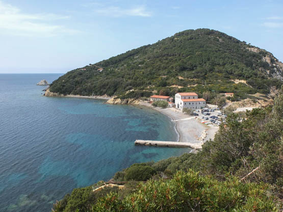
The beach and old tonnara factory on the Enfola promontory (Walk 33)
For Elba, the main port Portoferraio is a handy base with good facilities and accommodation, and is well served by buses. On the mainland is Campiglia Marittima, a lovely quiet place to stay, reachable thanks to buses from Campiglia railway station.
| Start/Finish | Enfola turn-off |
| Distance | 6km |
| Ascent/Descent | 330m |
| Grade | 1–2 |
| Walking time | 2hr 15min |
| Map | L’escursionista n.22 Isola d’Elba 1:25,000 |
| Access | The CTT Viticcio bus from Portoferraio will leave you at the Enfola turn-off. Otherwise by car drive to the beach car park – a saving of 30min. |
A must-do straightforward walk with grandiose views, this visits the lovely Enfola promontory with its wealth of flowering plants alongside a varied history of tuna fishing and defensive military fortifications dating to the 1920s. Superb lookouts and picnic spots are visited; the top spot is Capo d’Enfola, surrounded by colonies of herring gulls and looking out over the Tyrrhenian Sea. The walk starts with a stretch of road, then it follows a broad lane – a former military road – before a loop on narrow but clear paths.

From the bus stop at the Enfola turn-off, follow the road down to the isthmus at the foot of the Enfola promontory, where there are small beaches, a car park and restaurants/cafés (15min).
An old-style tonnara factory stands at the foot of the Enfola promontory. Tuna fishing on a large scale was introduced here in the 1600s by Granduca Ferdinando I and practised through to 1958. The migrating fish were channelled into nets and the catch was processed on land.
The building is now the headquarters of the Parco Nazionale dell’Arcipelago Toscano.
On the R of the National Park headquarters, take the lane marked n.108/Anello dell’Enfola (Enfola loop). In broad curves, mostly NW, you climb gently past fenced properties and masses of scented flowering shrubs, then through a gate with a National Park sign. Inspiring views over the gulfs on both sides and to the Tuscan mainland improve with every step you take, and derelict military buildings and well-placed benches dot the way.
Ignore the path fork R for n.108 (the return route slots in here) and continue through a deep cutting to where the lane concludes near an old tunnel. Now continue on the marked path through trees NE around the headland. Not far along is a small tunnel then a cannon emplacement, and soon afterwards you fork L (NW) at a sign for La Nave. This emerges from the trees onto rocky terrain bright with yellow shrubs of Jupiter’s beard and curry plants. A guiding rope helps you down to the final stretch of path to the wonderful rocky promontory of Capo d’Enfola (1hr), where you’ll probably stay at length watching the busy herring gull colonies on the adjacent cliffs.
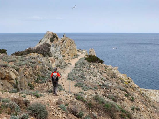
The path reaches the rocky headland of Capo d’Enfola
Walk back up to the fork on the main loop path and turn L to complete the circuit and rejoin the lane near the cutting. Then it’s L past the panoramic benches and downhill to return to the beach and car park (45min). A final 15min will see you back at the Enfola turn-off and bus stop.
| Start/Finish | Marciana Marina |
| Distance | 9km |
| Ascent/Descent | 430m |
| Grade | 2 |
| Walking time | 3hr |
| Map | L’escursionista n.22 Isola d’Elba 1:25,000 |
| Access | Marciana Marina has CTT buses from Portoferraio. Get off at the first bus stop in the village, outside Hotel La Primula. |
A beautiful and rewarding circuit that rambles across hilly and coastal landscapes in the island’s north-west. Starting out at the laid-back seaside village of Marciana Marina, it climbs through woods and long-abandoned terracing before dropping to the coast and La Cala, an inviting beach, where refreshments may be available in summer. Old paths lead over a headland back to the start.
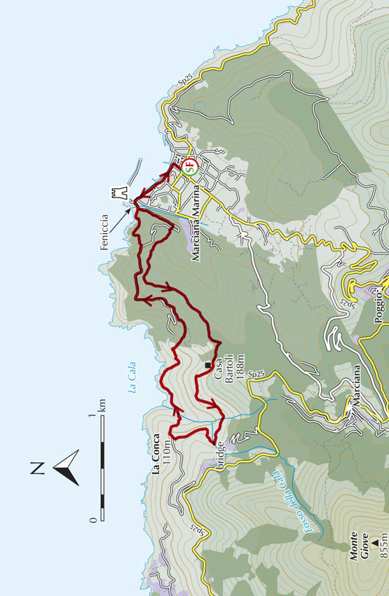
At Marciana Marina, from the bus stop outside Hotel La Primula, turn R and walk through to the waterfront, which you follow L past cafés and restaurants. At the far end, near the old tower, turn L past Ristorante Capo Nord and over a bridge to a small beach, Feniccia. Stick with this road as it heads uphill SSW.
Not far up, leave the tarmac for a clear path R (Percorso della Cala), cutting the road bends. Mostly NW, it climbs alongside a fence through terraces of pine trees which give way to Mediterranean shrubs. At a four-way junction, take the L fork (signed for Marciana) in easy ascent SW over rock and sand and through tree heather to a ridge.
The path through tree heather looks inland to Marciana and Monte Capanne
Further along, in holm oak woods, ignore a fork R; then only minutes along, at another four-way junction, leave the Marciana path and go sharp R (sign for S Andrea) down a sunken path. This soon bears W past old terraces and an abandoned house, Casa Bartoli (188m), proceeding in gentle shady descent to an isolated house, Montecagnolo. The way coasts over eroded terrain rife with wild boar diggings, among chestnut trees now. Ignore turn-offs and you’ll find yourself down at a lovely old brick-stone bridge over a cascading stream, Fosso della Cala.
The path, wider now, swings N out of the valley to La Conca (110m), a cluster of well-kept houses and gardens and a gravel road. Turn R downhill and almost immediately R again past a white house. Here, a stepped path begins a descent NE. After crossing Fosso della Cala, it’s up the opposite bank past houses and gardens above the glittering sea. A fork L soon leads to the nearby cove and beach of La Cala (2hr).
Back up on the main path, continue past modest Hotel Andreina and climb SE inland. After a stream crossing, ignore the turn-off L and go up old stone steps shaded by scented shrubs. A small house is followed by well-tended terraced gardens and great coastal views. Ignore a fork R for Marciana near a power pole and soon cross an unsurfaced road in holm oak woods. Not far up, leave the path (signed straight ahead for Marciana Marina) and fork L. You quickly drop to a quiet surfaced road.
Go R in gentle ascent NNE and past a house on a corner where you bear due E. About 1km from the house, leave the tarmac for the clear path L (E) downhill through shrubs and trees. Further down are panoramic benches overlooking tiny Feniccia beach.
You soon reach the road and turn L near the old tower. Continue along the waterfront at Marciana Marina and back to the bus stop (1hr).

The harbour at Marciana Marina with its watchtower
| Start | Marciana |
| Finish | Pomonte |
| Distance | 11km |
| Ascent | 540m |
| Descent | 860m |
| Grade | 2 |
| Walking time | 4hr |
| Map | L’escursionista n.22 Isola d’Elba 1:25,000 |
| Access | Both Marciana and Pomonte are served by CTT buses from Portoferraio. |
| Note | Before starting out, check on bus departures from Pomonte for the return trip. |
This superb itinerary traverses Elba’s vast scenic western headland below Monte Giove and Monte Capanne. It boasts astounding spring- and summer-flowering shrubs that transform the mountainsides into a gorgeous botanical garden with delicate pink and mauve rock roses, scented broom, rosemary, lavender and curry plant, and even orchids. The walking is straightforward, but due to its length the route is rarely crowded. There are cafés and groceries at the walk’s start and finish, although nothing in between. Several springs are encountered but it’s best to carry a good supply of water, just in case.
Marciana, the mountain village and walk start, occupies a marvellous dizzy perch high over the sea yet well below the island’s highest peak, Monte Capanne. Find time to ride the modest cabinovia, the open-sided gondola car that transports visitors to the top (April to September).


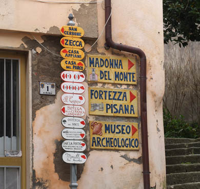
A batch of signposts at Marciana
Opposite the bus stop on the main road at Marciana (408m), go up the stepped way, Via Santa Croce, towards the village centre. Follow the ceramic signs for Madonna del Monte that point you uphill and into Piazza del Cantone. Keep R across the square and out through a medieval gateway to a war memorial and the Osteria del Noce restaurant. Take the broad, stepped ramp Via della Madonna up NW to cross a road and enter lovely chestnut woods interspersed with tree heather and pine trees.
The way is now marked with red-and-white stripes and n.3; en route are the sacred images of a Via Crucis (Way of the Cross). Past picnic tables, ignore all the turn-offs and continue W to the ancient chestnut trees at the Santuario Madonna del Monte (630m, 30min).
At the end of the buildings, a broad way (n.3) continues R, soon curving L (SW) high over the turquoise cove of Sant’Andrea. A beautiful level paved stretch at the foot of Monte Giove leads W in the company of scented shrubs, rock roses and curious wind-sculpted boulders to the scenic picnic area at Serraventosa (605m).
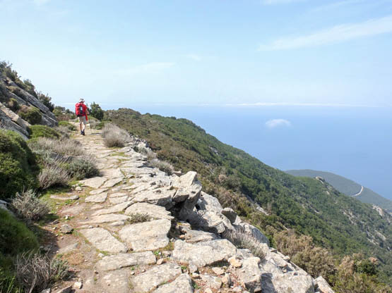
The broad paved way has amazing sea views
Shadier now, the path heads SE downhill into a chestnut copse to reach the Sorgente del Bollero spring (560m). Not far along, the way crosses trickling streams and begins a steady climb SW/W to the base of the marvellous Troppolo (684m, 1hr 30min).
On granite paving slabs, you leave the tree cover behind for more brightly flowering shrub cover. It’s not far to the junction where a path leads along a ridge to the Semaforo, an old signal station. Ignore this and continue SE/S on n.3, narrower now as it weaves up and down around outcrops and past the fork for n.10.
At the key Chiessi/Pomonte junction (475m, 1hr), go L (SW) on n.4 down past an old stone hut. The lavender-lined path cuts the flank of Valle di Pomonte, crossing vast rock slabs below Monte San Bartolomeo. You finally reach vineyards, vegetable gardens and modest houses.
At the road, turn R and very soon L down the steps of Via San Bartolomeo. This brings you out at the pretty square and whitewashed church of Pomonte (30m, 1hr). There are cafés for a refreshing drink, bus stops and a pebble beach nearby.
| Start/Finish | Porto Azzurro bus stop |
| Distance | 3.2km |
| Ascent/Descent | 100m |
| Grade | 1 |
| Walking time | 1hr |
| Map | L’escursionista n.22 Isola d’Elba 1:25,000 |
| Access | Porto Azzurro is a short CTT bus trip from Portoferraio. |
This delightful stroll from charming Porto Azzurro circles the headland occupied by the landmark star-shaped Forte Longone, dating back to the 1600s when Elba was under Spanish control. Now a penitentiary and closed to visitors, its mammoth walls of brick and stone can nevertheless be admired on this lovely walk which also looks across the gulf to Forte Focardo, built around the same time.
The walk links Porto Azzurro with the laid-back beach of Barbarossa, named after the infamous Saracen pirate. Cafés and restaurants can be found at both ends of the walk, which returns the same way to Porto Azzurro. Inviting panoramic benches dot the way.
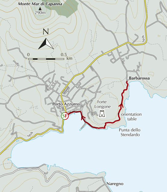
From the bus stop at Porto Azzurro, walk E along the seafront (Via Vitaliani), lined with restaurants and cafés, and through the charming village square. Stay with the road (Banchina 4 novembre), curving R all the way around past moored boats and a pier to the end of the tarmac. Here, a path begins a climb past prickly pears, asphodels and monstrous agave plants, with lovely views across the gulf.
You reach a lane and turn R to coast around the marvellous headland below the towering walls of the rambling Forte Longone. After Punta dello Stendardo, it’s N to a bench and a handy orientation table.
Further along, the way winds down through pine trees to the quiet beach of dark-coloured sand at Barbarossa (30min), backed by café/restaurants. After a swim or lunch, or both, retrace your steps to Porto Azzurro (30min).
A stepped way concludes at the beach of Barbarossa
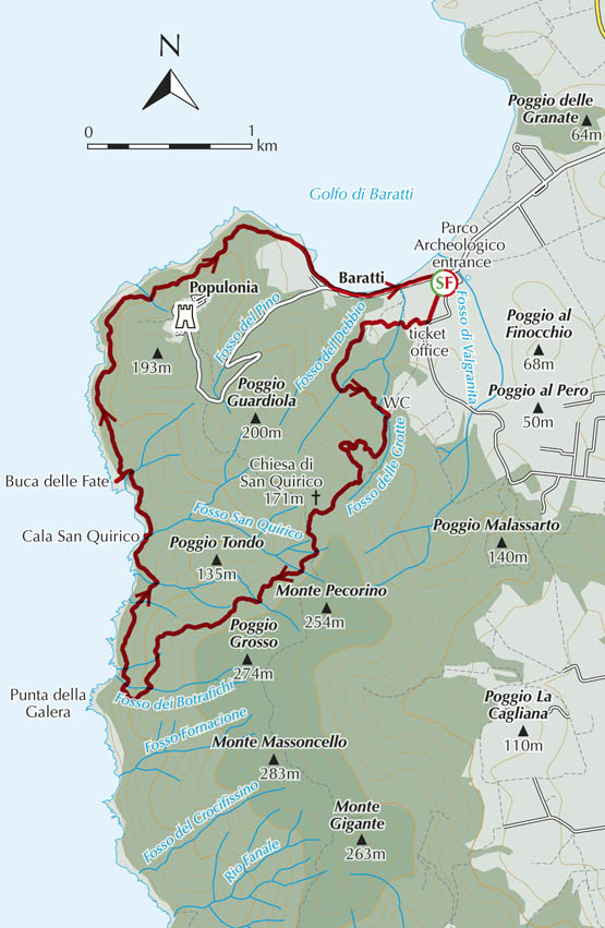
| Start/Finish | Parco Archeologico, Baratti |
| Distance | 12km |
| Ascent/Descent | 370m |
| Grade | 2–3 |
| Walking time | 3hr 30min |
| Map | Kompass n.2440 Toscana 1:50,000 map 3; a basic map is also available at the Parco Archeologico |
| Access | The occasional Tiemme bus from Piombino serves Baratti. Car parking at the Parco Archeologico entrance. A shuttle bus connects with Populonia. |
| Note | A modest admission fee is charged for entry to the archaeological site. See www.parchivaldicornia.it for opening hours and information. The guided visits are worth finding time for. |
This rewarding circuit begins with a visit to the fascinating Etruscan San Cerbone necropolis, named after a 6th-century bishop of Populonia. Helpful information panels in Italian and English line the way. Then it climbs through woodland to circle high above the sea around the headland, looking over to Elba. This stretch is narrow and can feel a little exposed in spots, earning the walk Grade 2–3 difficulty. Refreshments can be enjoyed at the marina and beach at the end of the walk, as can a well-deserved swim.
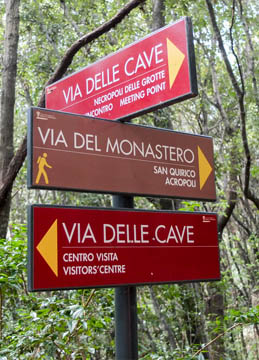
Route signposts in the Baratti Archaeological Park
At Baratti, from the Parco Archeologico entrance, walk through to the ticket office and Visitor Centre then follow signs for the Via del Ferro (the iron route, blue paint markers on trees) through the old industrial site and past scattered tombs. You reach a woodland clearing with picnic tables, a toilet block and the Centro di Archeologia Sperimentale.
Turn R onto the red-marked Via delle Cave (the quarry route) through dense holm oak woods in Fosso delle Grotte. Not far on, turn R on a stepped way via a series of underground chamber tombs with steep entrance corridors excavated into the rocky hillside. Nearby, after an ancient cava (quarry), is a marvellous lookout with lovely views over the Golfo di Baratti. Not far on, fork R to pick up Via del Monastero (brown markings). Heading uphill as a sunken way, it leaves the archaeological area via a turnstile, and reaches a lane. Keep L to the chapel Chiesa di San Quirico (171m, 1hr 15min).
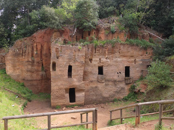
Underground Etruscan tombs are visited in the Baratti Archaeological Park
From here, proceed SW on shady red-and-white marked n.303 past the ruins of Monastero di San Quirico and down to fork R on steep n.302, aka Via del Cavalleggeri. This marvellous path leads N high above the rocky coast. Mediterranean shrub vegetation is thick on this stretch and you’ll often find yourself pushing through rock rose bushes, but the occasional gap affords lovely sea views.
The path drops in at the pebbly cove of Cala San Quirico then resumes ups and downs en route to Buca delle Fate (the fairies’ hole! 1hr).
Path n.302 now proceeds, narrower at times and with dramatic sea views over sheer cliffs, to round the Populonia headland, past vestiges of an old road and walls. Boar diggings are a constant presence. After a tiny lighthouse, you wind downhill looking over the vast Golfo di Baratti, and finally reach the marina and the road back to where you started out at Baratti (1hr 15min).
| Start/Finish | Piazza della Repubblica, Campiglia Marittima |
| Distance | 18km |
| Ascent/Descent | 250m |
| Grade | 1–2 |
| Walking time | 4hr 15min |
| Map | Kompass n.2440 Toscana 1:50,000 map 3 |
| Access | Campiglia Marittima and Suvereto can be reached by Tiemme buses from the railway station Campiglia FS on the Livorno–Rome line. |
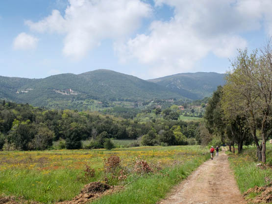
Two delightful hill villages are linked on this circuit in Val di Cornia. The outward route takes a quiet back road and a country lane as far as pretty Suvereto. The return loop follows paths and lanes through lovely rolling countryside, crossing wooded hills back to Campiglia Marittima, which you enter via the old Rocca fortress, a superb lookout.
Along with wildflowers, dotted along the way are cork oak trees, Quercus suber, which gave the village of Suvereto its name. Campiglia Marittima, on the other hand, is 8km inland from the coast, despite its name. Both villages have cafés, shops and restaurants.
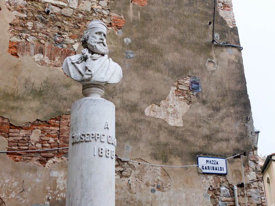
Piazza Garibaldi in Campiglia Marittima
From Piazza della Repubblica in Campiglia Marittima (230m), walk down Via Roma past tiny Piazza Garibaldi and out through an arch with views to the sea. Go L on Viale della Libertà, skirting the lower edge of the village to an intersection where you keep R. At the ensuing Y-junction, keep R again past the Asilo Nido Comunale kindergarten. Not far on, below the Ospedale, take the quiet and narrow Via delle Piagge downhill SE with a lovely outlook over the countryside. At the bottom, immediately after a fenced vegetable garden with olive trees, fork L (NE) on unsurfaced Via delle Volpaiole between peaceful rural properties and a knoll, Monte Pitti.
Just after a large house, the way forks – ignore Via di Fontanella and keep R in gentle descent near a stream, through Mediterranean woodland and passing the odd cork oak. Extensive vineyards soon line the way, which becomes an asphalted road. Accompanied by cypress trees and olives, keep straight on through a minor crossroads. As you reach a residential area and a fountain, follow the road L, signed centro storico. It’s not far up to Piazza Vittorio Veneto and a Romanesque church in Suvereto (90m, 1hr 45min).
Walk through the arched entry and the road lined with cafés, soon forking R on Via Piave. Signs point up to parkland and the Rocca, a ruined 12th-century castle that doubles as a marvellous belvedere.
Return to the café-lined street and fork R on Via Roma out of the village centre. Continue down Viale Carducci past a car park then L (signed tutte le direzioni). Soon red-and-white waymarks appear on a wall and direct you R on a side road, which quickly becomes a lane heading W into olive groves and pasture.
Keep R at the ensuing fork through woodland bright with cyclamens, following a clear path alongside a trickling stream. You cross a footbridge and join a lane – go L for a shady stretch NW past cultivated fields and a row of cork oak trees.
At a minor surfaced road, turn R and soon cross a bridge. Now path n.1 goes R but you stick with the road and turn L at the next lane, n.3. Up at a rise, branch R, climbing constantly. Where the way curves L for Azienda Agricola La Foresta near a huge cork oak with exposed roots, stay with n.3 as it breaks off R through dense Mediterranean woods and rounds Poggio Castagno (226m).
The lane heads into peaceful countryside towards Poggio Castagno
Keep R at a lane crossroads on a deeply rutted stretch. Not far on, n.3 branches R but you part ways with it now and veer L (S), soon passing a small abandoned quarry. The stony lane widens to give continuous sweeping views back to Suvereto and across hills and plains. Ignore turn-offs and enjoy the views as you stroll. Bearing W, you reach the yellow Ospedale building and tarmac on the outskirts of Campiglia Marittima.
Turn R at the road near the Asilo Nido passed earlier on, then – unlike the outward route – R again uphill past a B&B. Just after a bus stop, take the path off L for access to the ruins of the Rocca and an impressive vaulted 13th-century cistern.
Exit the Rocca on the opposite side on narrow paved alleys winding downhill through Campiglia Marittima, keeping L. At the Museo, go R then immediately L, past a palace facade plastered with marble crests and inscriptions, to Piazza della Repubblica (2hr 30min).