Walk 42 leaves Pitigliano
Walk 42 leaves Pitigliano
Southernmost Tuscany has beautiful swathes of unspoilt coastline backed by sand dunes, thriving Mediterranean maquis and hilly woodland. It is dotted with old watchtowers, a legacy of the 14th–16th centuries when the area was under the constant menace of pirate raids by corsairs such as the infamous Barbarossa, who carried off many a maiden destined for a distant harem. The name Maremma, as the area is known, means ‘maritime’. Once swampy, mosquito-ridden and malaria-prone, it began to undergo large-scale land reclamation in the 18th century. Drainage channels were dug and maritime pines planted, both to anchor the sand dunes and to filter salt-saturated winds that would otherwise damage the valuable umbrella pines, important for their crops of pine nuts.
Parallel to the coast and backing stunning beaches are the modest limestone Monti dell’Uccellina, named ‘little bird’ for the multitudes of winged migrants that take refuge here. Permanent inhabitants include the timid wild boar, their presence confirmed by telltale scratching and digging, along with small deer and large birds of prey. Mediterranean woodland predominates, with holm oak, once important for charcoal burning, and cork oak with its thick fissured grey bark, once an important source of income here. The hills form the backbone of the Parco Regionale della Maremma (www.parco-maremma.it), established by far-sighted nature lovers in 1975 on an unspoilt 100km2 area with 25km of pristine coast. Walks 39 and 40 explore the Maremma Park, although more routes are feasible to keen walkers – enquire at the main Visitor Centre and entrance at Alberese.
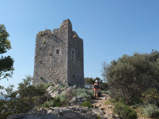
Torre di Castel Marino watchtower (Walk 39)
Not far south, where the Argentario promontory juts out into the sea, is the placid lagoon of Orbetello, the largest on the Tyrrhenian seaboard and a haven for a multitude of resident birds – such as flamingoes and black-winged stilts – as well as those stopping over during long migratory flights. The quiet waterfront town of Orbetello is a good base for visiting the area. Birdwatchers will appreciate visiting the two World Wildlife Fund (WWF Italia) reserves close by (www.wwf.it/oasi/toscana).
The southernmost boundary of the lagoon is a tombolo, or sand spit, now the Riserva Naturale Duna Feniglia visited in Walk 41. Averaging 1km in width and 6km in length, it comprises a long stretch of stunning deserted beach backed by reclaimed dunes and shady avenues lined by towering pines. In the 1800s, this area was sold off and its trees cut down to make room for pasture. No longer protected from the sea, the lagoon on the northern side underwent dramatic changes, filling up with sand. Along with great losses for the fishing industry, this led to repeated outbreaks of malaria. The trend was thankfully reversed as of 1911, when the first maritime pines were planted. Not only are they perfectly suited for dune reclamation but they can also be tapped for turpentine. Today, stone pines and other Mediterranean trees add variety.
A poignant point of interest: in 1609 the great Renaissance artist Caravaggio was found here, gravely ill; he was transferred to Porto Ercole, where he died soon afterwards.
Surprising contrasts come a short distance inland with the charming yet little-visited town of Pitigliano and its surroundings. This is a very special corner of Tuscany. The ancient Etruscans were at home on the photogenic tufa outcrops, which they linked by excavating vie cave, deep sunken roadways still visitable today. A profound sense of history pervades the area, and very little effort is needed to imagine all the feet, wheels and emotions that must have passed this way through the ages. Nowadays there are good bus links with Grosseto and the coastal railway.
An imposing and fascinating stronghold, Pitigliano perches on a steep-sided eye-catching platform and its houses seem to grow out of the reddish rock. It took shape in the Middle Ages under the Aldobrandeschi and Orsini families, who left a massive palace and fortress, not forgetting the landmark aqueduct.
The town makes a good base for Walk 42. This memorable walk concludes at the pretty village of Sovana, close to a fascinating Parco Archeologico comprising an unusual Etruscan necropolis of decorated tombs and myriad sunken ways (www.leviecave.it).
Another key village is Sorano, clinging with varying degrees of success to a dramatic buttress over a gorge, although thankfully its tufa rock base has been successfully consolidated. Since 1929, when the town was all but evacuated due to major landslips, many former inhabitants have moved to new housing nearby; however, the old pedestrian-only nucleus is gradually coming back to life. Looming overhead is a massive 16th-century Fortezza, a maze of ramps, moats and monumental doorways.
Sorano is the start for Walk 43 to Vitozza, a unique grouping of 200 evocative cave dwellings now colonised by moss and ferns and part of a Parco Archeologico (www.leviecave.it). The origins of the settlement can be traced back to the 1200s; thereafter it developed into a fully fledged township complete with churches, fortress and defensive walls, not to mention practical trappings such as water cisterns, dovecotes, olive and wine presses, ovens and mills. Over time, the inhabitants moved to normal houses in adjacent San Quirico, the last in 1783.
In the Feniglia Reserve, the way leads towards the sea (Walk 41)
At the southern extremity of the Maremma Park, Talamone has hotels and buses to Fonteblanda, where there are trains. Further down the coast is Orbetello, with accommodation as well as bus links to Orbetello Scalo railway station.
Inland, Pitigliano makes a perfect base, with buses to Grosseto and trains, in addition to good facilities; otherwise there’s even quieter Sorano, with accommodation and buses.
| Start/Finish | Pratini |
| Distance | 7km |
| Ascent/Descent | 150m |
| Grade | 2 |
| Walking time | 2hr 30min |
| Map | Edizioni Multigraphic Parco della Maremma 1:25,000; or Maremma Park map |
| Access | From the Maremma Park entrance at Alberese (Tiemme bus from Alberese railway station), the Park shuttle bus runs 5km to Pratini. The fare – and route map – are included in the entrance fee. Remember to check on return bus times before starting out as it’s a long walk back if you miss the last one! |
| Note | In midsummer if fire danger is high, the Park may be closed or visits limited to guided walks. Check at www.parco-maremma.it. |
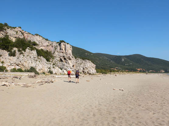
A pristine sandy beach and pirate watchtowers built by Duke Cosimo dei Medici are the stars of this superb walk inside the Maremma Park. Following the official A2 route, it gives first-time visitors an excellent overall picture of the area. Refreshments and groceries are on sale at the walk start, Alberese. Don’t forget your swimming costume.
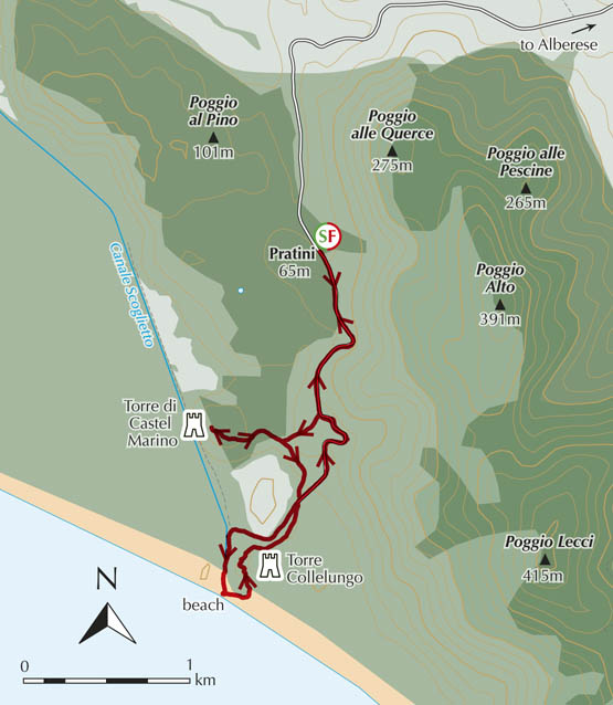
From Pratini (65m), meaning ‘little meadows’, where the shuttle bus turns around, walk down the narrow road for about 10min to where A2 forks R (SW). The clear path drops through bushland to a signed junction where you take the R branch. It’s not far up to the stunning limestone outcrop occupied by Torre di Castel Marino (95m, 50min).
From Torre di Castel Marino, bird’s-eye views take in the 600-hectare pine forest, planted in the 18th century and run through with drainage canals, as well as the coast, distant islands and the Monti dell’Uccellina range.
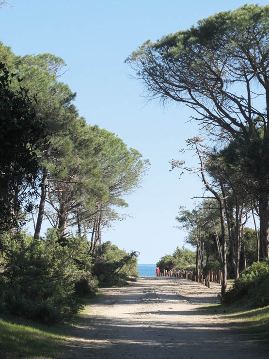
Return to the junction. Go R (S) through a gate to an old olive grove in a sloping field where you follow the fence down to the road. Now it’s R past an old stone wall. Further down, you walk along a lovely canal on the edge of the pine plantation, before taking a sandy path through the dunes to the glorious beach, where a divine swim and picnic are de rigueur.
It’s hard to leave the glorious sandy beach
When you manage to drag yourself away, follow A2 as it goes L (N) at the base of a limestone knoll and up a rocky path to gain the amazing position of Torre Collelungo (40min).
The path continues NE along the scenic ridge, climbing a little, before dropping back to the road at the old stone wall. Route A2 now turns R, sticking with this quiet road through the olive groves and shrubs all the way back uphill to Pratini (1hr).
| Start/Finish | Pratini |
| Distance | 7.8km |
| Ascent/Descent | 400m |
| Grade | 1–2 |
| Walking time | 2hr 45min + 45min extension |
| Map | Edizioni Multigraphic Parco della Maremma 1:25,000; or Maremma Park map |
| Access | From the Maremma Park entrance at Alberese (Tiemme bus from Alberese railway station), the Park shuttle bus runs 5km to Pratini. The fare – and route map – are included in the entrance fee. Remember to check on return bus times before starting out as it’s a long walk back if you miss the last one! |
| Note | In midsummer if fire danger is high, the Park may be closed or visits limited to guided walks. Check at www.parco-maremma.it. |
This walk – Maremma Park route A1 – crosses the wild hills of the Monti dell’Uccellina to the abandoned Benedictine abbey of San Rabano, which was both active and influential from the 10th through to the 16th century. Under the monks, large areas of forest were cleared for agriculture and in all likelihood a settlement grew up nearby.
The well-marked path is accompanied by a surprising variety of dense maquis vegetation and trees, but clearings afford wide-ranging views over the magnificent coastline. An optional but recommended beach detour is also given. Take food, drink and a swimming costume. Refreshments and groceries are on sale at Alberese.

From Pratini (65m), meaning ‘little meadows’, where the shuttle bus turns around, signposting for route A1 sends you off E up a shady corridor of holm oaks, with loose stones underfoot. Up at a panoramic corner are lovely views to the sea, towers and to the Ombrone plain. The way veers R (S) through woodland and clearings left by long-gone charcoal burners. With a gentler gradient, the path weaves its way over undulating terrain to gain the highest point on the Monti dell’Uccellina, namely Poggio Lecci (415m), and an aerial.
A grassy clearing, perfect for picnics, gives a superb panorama over rolling woodland to the coast, with Isola del Giglio sprawling on the south-east horizon, beyond the Argentario promontory.
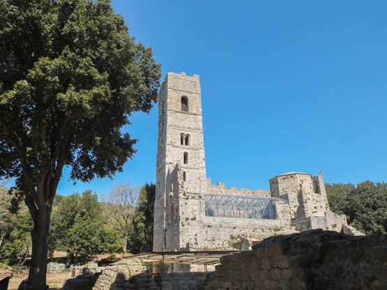
The beautiful abbey of San Rabano stands in dense woodland today
A gradual descent leads to the evocative ruins of the Abbazia di San Rabano (325m, 1hr 45min), the white stone Romanesque abbey almost hidden in a wood of tall oak trees.
This point is the furthest south on the walk and now path A1 proceeds NW through scrub. Two wooden lookout platforms en route offer more superb views over the lovely bay Cala di Forno. Downhill at a decent rhythm you drop to an olive grove with ancient gnarled trees, before emerging on the narrow surfaced road (Via degli Olivi, 66m, 45min). To return to Pratini and the bus, turn R uphill for a final winding 15min on foot.
Alternatively, the following detour to a perfect beach for a dip in the Tyrrhenian Sea is recommended as an appropriate reward for walkers.
On reaching the narrow surfaced road (Via degli Olivi), turn L down the road in common with route A2 then across the dunes to the beach. Afterwards, duly refreshed, retrace your steps to Via degli Olivi (45min return) and follow it up to the bus stop at Pratini (15min).
The path through the dunes to the beach
| Start/Finish | Feniglia Reserve, western entrance |
| Distance | 12km |
| Ascent/Descent | negligible |
| Grade | 1 |
| Walking time | 2hr 30min |
| Map | Edizioni Multigraphic Parco della Maremma 1:25,000 |
| Access | Feniglia’s western entrance is 3.5km from both Orbetello and Porto Ercole. Tiemme buses between Orbetello Scalo railway station and Porto Ercole stop nearby. From the bus stop, take the lane E, and keep L past the car park to the Feniglia Reserve entrance. |
This relaxing easy stroll visits both the lagoon and the sea side of the forested Riserva Naturale di Feniglia. The walk is easily shortened by turning back when desired – or lengthened thanks to the many side paths and the inviting beach. Don’t forget a swimming costume, picnic, and binoculars for watching birds and the fallow deer that are at home here.
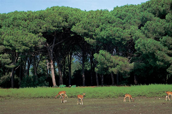
Fallow deer graze freely in the Feniglia Reserve
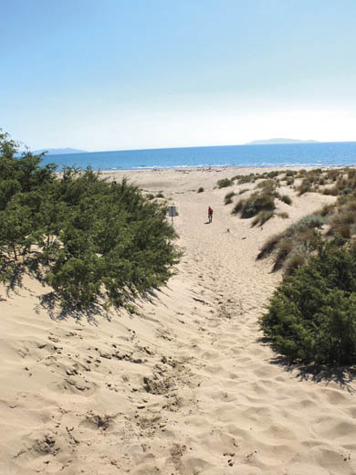
From the entrance to the Riserva di Feniglia, go first L onto the walkway through to an observation platform at the lagoon edge, looking across the placid body of water that is enlivened by bird life and fish-breeding enclosures. Subsequently retrace your steps and continue straight ahead on the wide shady avenue leading S and lined by magnificent maritime pines.
The way veers L (ENE) to where a succession of paths – signed as varco (opening) – make a beeline R through the dunes to the long beach looking out south over the Tyrrhenian Sea. Go L and stick with the seafront – the sand is firm and walking is pure pleasure. When you’ve reached the far end (1hr 20min) – or had your fill – veer L inland for the return route.
A shady lane proceeds W parallel to the beach, under the beautiful canopy of pines in peace and quiet, uninterrupted but for the chirp of crickets and the sound of distant waves.
Clearings are home to fallow deer who criss-cross the wood with their tracks, grazing undisturbed but for the occasional walker or cyclist. The deer were introduced in 1954 to stop false acacia from taking over the undergrowth. So successful were they that the bush has completely disappeared while the deer now number 200 and are quite at home.
Return to the westernmost end of the Feniglia Reserve and the entrance where you started (1hr 10min).
| Start | Pitigliano |
| Finish | Sovana |
| Distance | 7km |
| Ascent | 120m |
| Descent | 140m |
| Grade | 2 |
| Walking time | 2hr |
| Map | Kompass n.2471 Lago di Bolsena 1:50,000 |
| Access | Pitigliano has Tiemme buses from Grosseto. Services back from Sovana are a little less frequent, but you can always call the local taxi (tel 0564 635424 or 335 7615602). |
| Note | There is very little waymarking en route so directions need to be followed carefully. The usual rule applies: if in doubt, bail out and retrace your steps. |
‘Nearly every rock here speaks Etruscan’, wrote George Dennis in his 1848 masterpiece The Cities and Cemeteries of Etruria. Surprise after delightful surprise is in store for walkers who venture along the ancient Etruscan-era vie cave (sunken lanes) that wend their way through tufa landscapes between charming Pitigliano and enchanting Sovana. Wild rambling landscapes are traversed, with pasture plains interrupted by abrupt ravines excavated by eroding watercourses. Many vie cave have been cleared of brambles and debris, although steepish leaf-filled passages can be slippery and muddy.
At Sovana, the walk’s end, don’t miss a visit to the extensive Etruscan necropolis in the Parco Archeologico, a short stroll outside the village.
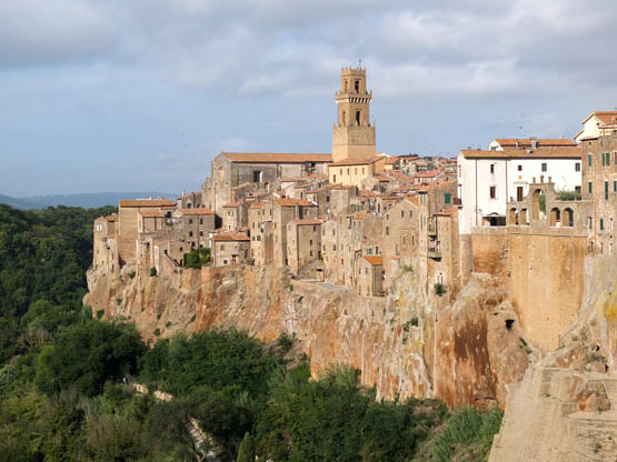
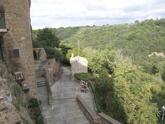
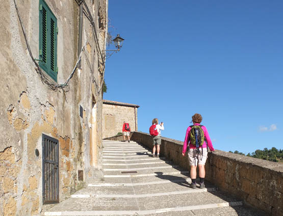
Spectacular Pitigliano seems to grow out of the rock
From the bus stop in Via Santa Chiara at Pitigliano (313m), follow the signs for the centro. These lead past Albergo Guastini and under the monumental town gateway, Porta della Cittadella. In Piazza Garibaldi (home to the Tourist Office), bear L along the street flanking the 16th-century raised Medicean aqueduct, past Fortezza Orsini and into the older part of Pitigliano. Where the main street forks, keep L on Via Zuccarelli, admiring the narrow alleys and passageways that lead off it. After the synagogue and Jewish quarter, the way becomes Via Aldobrandeschi, in descent.
Just before a lookout where the road ends, fork R down Via Porta di Sovana, winding out of town. At a lane, keep straight ahead in descent past fig trees and a pylon to the start of the Via Cava Poggio Cani. The way soon forks – go R for the narrow descent between tall cliffs clad in wire netting and man-made cavities.
Down at the roadside, turn R as far as a sign for Via Cava Fratenuti, where you join a path in the same direction alongside the tarmac behind the guard rail. Once across the bridge over the River Lente, at picnic tables, fork L on a lane. This leads past allotments to the entrance of Via Cava San Giuseppe, where you step straight into another world on an excavated way beneath tall cliffs.
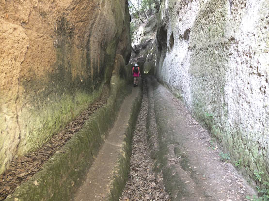
In the Via Cava San Guiseppe
Up at a fork (ignore L for Fontana dell’Olmo), branch R up to a lane where it’s R again past grapevines and fields to a minor road, Via San Pietro. Go R again (E) past rural properties, with lovely views back to Pitigliano.
At a three-way intersection (1hr), go L and immediately L again on a lane signed for Sassotondo, in common with RET walking route n.2. This leads NW between fields to the entrance for the Sassotondo winery. Here, keep straight ahead across the rutted terrain of Piano Conati, witness to ancient roads. Follow the fence at first until a clear path leads through bushes of rock roses and broom.
Further along, you begin to descend into woodland via yet another fascinating via cava. Not far down are ruins of masonry where you fork R up the bank then immediately L (still NW). The path continues downhill to cross what’s left of a narrow bridge over the stream Fosso del Puzzone. Immediately after it, veer L on a faint path that quickly leads into woodland for a sunken path. Up at a wide lane, turn L to a minor road (and signs for paths 002/005) and stick with this straight ahead past playing fields and dipping over a watercourse.
It’s not far up to the foot of the Rocca Aldobrandeschi, where you keep L through to the single main street of laid-back Sovana (291m, 1hr) with its Romanesque churches.
| Start | Sorano |
| Finish | San Quirico |
| Distance | 7km |
| Ascent | 200m |
| Descent | 80m |
| Grade | 1–2 |
| Walking time | 2hr 20min |
| Map | Kompass n.2471 Lago di Bolsena 1:50,000 |
| Access | Sorano has Tiemme buses from Pitigliano; some take in San Quirico, handy for the return. Otherwise return to Sorano by taxi (tel 0564 635424 or 335 7615602) or on foot. |
An exciting walk through wild areas steeped in history, this itinerary commences at the picturesque medieval township of Sorano and heads along a wooded valley to Vitozza, erstwhile cave/rock settlement, a remarkably atmospheric spot. The conclusion is at San Quirico.
As far as the walk goes, apart from the odd overgrown stretch in the river valley, the only tricky spot is when a stream is forded, usually straightforward except after heavy rain. Refreshments are available at Sorano and San Quirico.
Starting out at the main square and Municipio of Sorano (385m), go downhill N past the spectacularly placed bakery, arcades and the Tourist Office. An arched gateway leads onto Via Giovanni Selvi where you follow signs for the Masso Leopoldino, weaving your way through narrow alleys and down along the foot of a sheer masonry wall. Ignore the stepped way forking R for the time being, and continue straight ahead via Piazza del Poggio to the wonderful terrace of the Masso Leopoldino, a curious structure dating back to the 1700s.
The walk climbs to the Masso Leopoldino
Return to the foot of the wall and turn L on the main picturesque lane winding downwards past tiny stone houses, finally exiting Sorano by way of the lower gateway, 16th-century Porta dei Merli, complete with drawbridge slits. A paved lane continues E towards the River Lente. Soon keep R at a junction to coast above the watercourse past groves of walnut trees and out to a minor road. Go L on the tarmac to a bridge (325m). Don’t cross over but stick to the R bank along a path with occasional red-and-white waymarks. You cross a side stream and continue through undulating woodland. After a picnic table are extant lengths of the old aqueduct.
An overgrown field is followed by a small-scale tree plantation then a picnic area. Now the path descends a little. Keep R (unless you’re not bothered by slippery stepping stones straight ahead) following red-and-white markings to a nearby ford before the paths loops L. Then it’s mostly E following the R bank of the river again, on a well-trodden way along the NW base of the outcrop that houses Vitozza, although nothing is visible yet. Ignore the first signed fork R uphill and stay with the path in gentle ascent to wooden arrow signs pointing R to a delightful sunken mossy section. This leads up past numbered caves to a clearing in the heart of Vitozza (425m, 1hr 40min).
Proceed through a section of old wall and R to a dizzy cliff edge high above Fosso Felcetone to the fascinating columbarium. Return to the clearing and go R (SE) for the Uscita (exit). This path skirts a host of unusual cave dwellings. Do take one of the optional turn-offs L to enter the city proper, with the meagre ruins of its castle among oaks and crocuses, the vestiges of a church, and a lookout where the countryside for miles around can be seen.
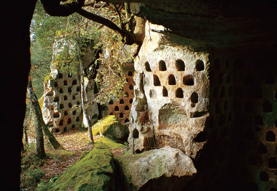
A medieval columbarium at Vitozza
Back down on the main exit track, continue SE to the Visitor Centre and toilet block. The last leg continues in the same direction past yet more caves. Walk through to the outlying houses belonging to the quiet village of San Quirico (506m, 40min). There’s a shop and restaurant in the square, and it’s up R for the bus stop.