
This book was to have ended here, with the defeat of the Gauls and the exodus of Druids to Britain. ‘Their science crossed the ocean’, said Pliny, ‘and reached the void of Nature’ (by which he meant Britannia). It was in this cul-de-sac of the north that Druidism or some of its religious traditions had been ‘discovered’, according to Caesar. He, or his Druid informant, called it a ‘disciplina’, which suggests an institution capable of organizing a body of knowledge into a curriculum. But where were the schools of Iron Age Britain? And where, for that matter, were the towns? ‘The Britanni’, said Caesar, ‘fortify their tangled woods with a ditch and a rampart and call it a town’. The British king, Cassivellaunus, spoke Latin, but he must have learnt it on the Continent, just as the sons of Highland chiefs in seventeenth-century Scotland left their glens to go and study at the Sorbonne in Paris.
The sorcery of received ideas covers the British Isles with a coarse and heavy cloak. It is hard to picture a system of solar paths stretching so far from its Mediterranean origin and easy to believe that, after the conquest of Gaul, Britannia waited in its primeval squalor for the Roman landlords to come and install the plumbing and the central heating. Not until AD 43 would a beacon fire be lit on top of a watchtower on the Kentish coast to announce to the Continent that Britannia belonged to the Roman empire.
But if Britannia truly was a homeland of Druidism, and if, as Caesar was informed, ‘those who wish to make a more assiduous study of it generally go there to learn’, it can hardly have been such a backwater. There is, in fact, a trace of Druidry in the Celtic name of the islands, though its meaning has been lost for almost two thousand years. ‘Prettanike’ was the name heard by Pytheas in the fourth century BC; ‘Britannia’ was the form familiar to Caesar. The inhabitants would originally have been the ‘Pritani’ or ‘Pret(t)anoi’. The name belongs to a group of words whose Indo-European root means ‘to cut’, ‘to form’, ‘to shape’. In early medieval Ireland, the ‘figured folk’ of Britain were assimilated to the ‘painted’ or ‘tattooed’ Picts of Scotland. Convention has sealed the interpretation, and the accepted history of Britain now begins with a population of barbarians who smeared themselves with the blue dye of woad.
Some Celtic tribes, like the ‘painted’ Pictones or Pictavi of Gaul, were named for their visible attributes. Many others had names that referred to religious ritual: the People of the Dance (Lingones), of the Sanctuary (Nemetes), of the Cauldron (Parisii); the Shining Ones (Leuci), the Bright Ones (Glanici). The Pritani of Britannia probably belonged to the latter group. The name is often found, as Prito, Pritto, Pritillius or Pritmanus, on fragments of Iron Age and Gallo-Roman pottery from Gaul and northern Germania. Like ‘Mason’ or ‘Smith’, the name was the mark of a profession. In ancient Celtic, ‘pritios’ had the same dual meaning as the Greek ‘poietes’: a creator, a craftsman, an enchanter and a poet.
The protohistoric inhabitants of Britain were not, by name, the face-painted belligerents beloved of British nationalists. They were makers, not destroyers. They excelled in the arts of verse and incantation. The name ‘Prettanike’ belongs to the distant age when an early form of Druidism existed in the British Isles. The scientific traditions of the Druids may have been Hellenistic, but their bardic and religious heritage belonged to the ancient land that should now be reimagined as the Poetic Isles.

The legend of a Mediterranean sun god impregnating the daughter of a mythical King Bretannos reflects the realities of trade and cultural transmission in the first century BC. Even for mortals, the Oceanus Britannicus was not a barrier. Branches of the Atrebates and the Parisii had migrated to Britain; the Catuvellauni of the Thames Basin were probably relatives of the Catalauni of Champagne. In the regions closest to the Continent, pottery, coins and burials show a similar culture developing on both sides of the Channel in the aftermath of the Gallic War. And far beyond the civilized south-east, there are places that bear the name of the god Lugh, and many others that were nemetons or ‘sky sanctuaries’ of the Druids (fig. 54).
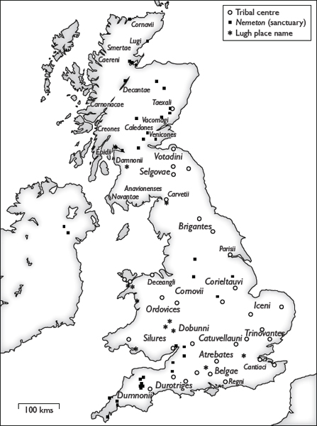
54. British tribes
The tribal names are known from ancient historians and geographers, the civitas capitals of the Romans and inscriptions. In northern Scotland especially, the limits of tribal territories are a matter of speculation.
If the Gaulish system of solar paths was extended across the Channel, the evidence should be easy to discover. Though the ethnographic information is scantier than it is in Gaul, enough British tribal centres have been identified to make corroboration possible. But at first, the patterns that are so vivid in Gaul are nowhere to be seen. Nothing in Iron Age Britain suggests that the Heraklean ratio of 11:7 was ever applied to any system of paths or hill forts. There is just the faintest whirring of a Druidic mechanism, but it comes from a place that lies a long way from the south coast, in a corner of the county of Shropshire, in the lands of the Cornovii.
The market town of Whitchurch, which claims to be ‘old but not old fashioned’, prides itself on being the birthplace of the man who wrote the light opera Merrie England. It lies just three kilometres from the Welsh border. The town is recorded by Ptolemy and by two other ancient sources as ‘Mediolanum’. Disregarding its neighbouring hills, Whitchurch, like Milan, interprets its ancient name as ‘middle of the plain’. This is the only known Mediolanum in England, though there was a ‘Mediomanum’ (probably a scribe’s misspelling) somewhere in mid-Wales,* and the Medionemeton on the Antonine Wall. Otherwise, the map of British Middle Earth is almost blank.
Unlike the Scottish Medionemeton, which was the mid-point of a survey line joining sea to sea (p. 52), Whitchurch is not an obviously significant ‘middle sanctuary’. It stands at a junction of Roman roads, but then so does almost every other place whose ancient name has survived. It does, however, possess some curious properties, which make it a British twin of the prime Gaulish Mediolanum, Châteaumeillant.
Like Châteaumeillant, Whitchurch-Mediolanum occupies a border- land that was probably a buffer zone between Celtic tribes. Parish, county and national boundaries, some of which date back to pre-Roman times, form such a tight knot in the vicinity of Whitchurch that a walker who finds a fascination in such things can set off from the town centre at dawn and stand on five triple intersections or ‘tripoints’ before noon.
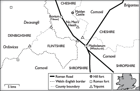
55. The area of Whitchurch (Mediolanum)
These are the historic county boundaries, before the reforms of 1965 and 1974. One of the ‘tripoints’ (where three boundaries intersect) is a ‘quadripoint’: four parishes meet at the place called No Man’s Heath.
Whitchurch also shares with Châteaumeillant one of those happy accidents of geography that the Druids of Gaul exploited so skilfully. Châteaumeillant – the Mediolanum of the Bituriges – stands on the longest line that can be drawn through Gaul from north to south. Whitchurch – the Mediolanum of the Cornovii – stands on a meridian that runs almost the entire length of Britain. Anyone who has tried to trace a north–south route through the non-consecutive sheets of a road atlas will know that Britain is awkwardly skewed to the west. Leaving the part of southern England known as the West Country, and heading due north, one ends up in eastern Scotland; the Atlantic waters of the Severn Estuary are on the same line of longitude as the Firth of Forth, which is an inlet of the North Sea. The Whitchurch meridian is the longest line that can be drawn through the tilted island of Britain. It crosses three estuaries, but not the open sea, before reaching the northern coast of Aberdeenshire.
As a line of mid-longitude (p. 62), the Whitchurch meridian could hardly be bettered. It begins at a hill called Beacon Knap above the Dorset coast and ends at Portsoy or Port Saoidh, whose name means ‘Harbour of the Warrior’ or ‘the Scholar’. By contrast, the line of mid-longitude that was chosen by the British Ordnance Survey – and perhaps, too, by the first Roman surveyors – crosses one hundred and seventy kilometres of the North Sea.
A legend preserved by medieval scholars suggests a native British tradition of long-distance surveying predating the Roman conquest. One of the first to have recorded it was Geoffrey of Monmouth, whose Historia Regum Britanniae (‘History of the Kings of Britain’) was written in about 1136. According to the Historia, in the old days before the Romans, a mythical King Belinus ordered a causeway to be built ‘which should run the whole length of the island, from the sea of Cornwall to the shores of Caithness, and lead directly to the cities that lay along that extent’. Like Herakles on the Via Heraklea, Belinus conferred on all who travelled on his roads ‘every honour and privilege, and prescribed a law for the punishment of any injury committed upon them’. Whatever the source of the legend – a tale told by a Welsh bard or a manuscript found by Geoffrey in Oxford – it has the mark of the Druids: the name of the mythical road-building monarch is that of a Celtic god of light, Belenos or Belenus.
The Druids’ geometric plotting exactly matches the mythical truth. The Gaulish meridian, projected from Châteaumeillant to Loon Plage and across the Channel, would have missed the British mainland by about thirty kilometres. In order to extend the system into Britain, retaining the points of reference that defined the place of Celtic lands in the wider world, the Druids would have chosen the meridians or lines of longitude that run ten-minute increments to the west of the prime Gaulish Mediolanum. And this is what the map reveals: the more westerly of the two lines, directly connecting Heraklean Gaul to the homeland of the Druids, is the Whitchurch meridian.
Given what we now know about the Druids, the coincidence can hardly be called astonishing, though it is, all the same, astonishing. As is the tidy fact that if the same operation is extended to the west, into the remotest of Celtic lands, the next meridian passes through the Hill of Uisneach (within twenty-nine seconds of daylight). In Celtic mythology, the Hill of Uisneach, with its royal burials and ring forts, was the sacred centre or omphalos of Ireland (see p. 274).
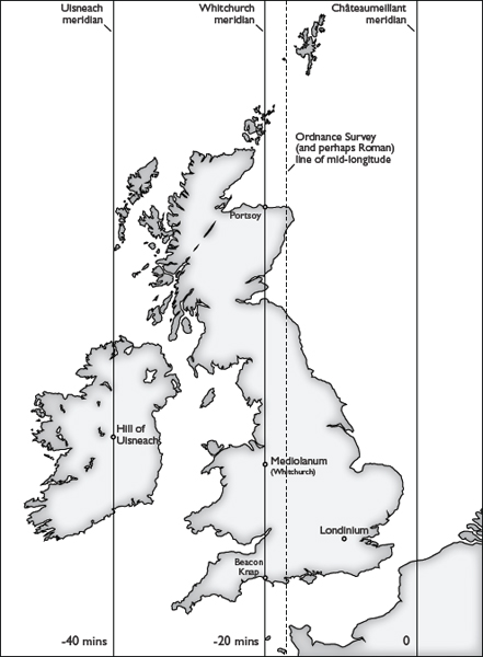
56. Meridians of the British Isles

Without the corresponding solstice lines to reveal a network of solar paths, the Whitchurch meridian is a slender thread on which to hang even a virtual expedition. Yet that slender thread traces out a comprehensive mystery tour of ancient Britain and the geometric basis of a wonderfully coherent system.
Shortly after leaving Beacon Knap in Dorset, the meridian passes by the foot of Glastonbury Tor, near the site of a nemeton, and then through the village of Nempnett Thrubwell, whose name has the same origin. Comparatively few British tribal capitals are known, but the meridian bisects several of them, as though in obedience to the commands of Belinus: the road ‘should run the whole length of the island . . . and lead directly to the cities that lay along that extent’. These tribal capitals include more than half the likely centres of Scottish tribes.* The meridian also encompasses twenty hill forts, some of which may have marked an ancient Welsh frontier.
On several sections of its unerring course, the Whitchurch meridian shows a remarkable attraction to boundaries and their intersections. After reaching the tripoint where Wales meets the Anglo-Saxon kingdoms of Mercia and Wessex, it follows the Welsh border for twenty-two kilometres, then crosses back into England near the tripoint of Gloucestershire, Herefordshire and Monmouthshire. At Whitchurch, at approximately one-third of its total distance, it crosses the boundary region shown on the map (fig. 55). Further north, before the Mid Hill that marks two-thirds of its length, it crosses the lonely clearing in the Kielder Forest where Cumberland and Northumberland meet Scotland.
One of the meridian’s most intriguing characteristics is its close relationship with long-distance routes. In Dorset, it bisects an important town of the Durotriges called Lindinis (Ilchester). In the early days of the Roman conquest, this was the southern terminus of the Fosse Way, which runs diagonally across the country to Lincoln and forms what many historians believe to have been the first Roman frontier in Britain. After crossing the Severn Estuary at a hill-fort complex of the Silures tribe, it meets the southern terminus of another ancient route, marked by the eighth-century earthwork known as Offa’s Dyke. Over its entire length, the meridian passes over eight and perhaps nine Roman road junctions, as though the Romans had somehow keyed their network into the ancient road of Belinus.
Of course, one straight line is not a network, and there are so many hill forts, especially in south-west England and the Welsh Marches, that if an ant walked across the printed map, its trail would probably take in about the same number of significant places. Appropriately, the meridian passes through the hills and dales that were the stamping-ground of Alfred Watkins, the discoverer or inventor of ley lines (p. xiv). In the dense scatter of pre- and proto-historic sites in Herefordshire and Shropshire, the possibilities for single-minded expeditions along an ‘Old Straight Track’ are practically endless.
As Watkins found, different eras merge in these forts and refuges that were inhabited for thousands of years. Out of this confusion of eras, oral tradition conjures simple figures to speak for all the centuries. One of those figures is the Devil, whose ‘Mouthpiece’ – on the meridian by the deserted village of Witchcot – is nothing more mysterious than an old sandstone quarry. Another is the real or legendary King of the Britons, Arthur. He first appears at Glastonbury Tor, one of the fabled locations of the Holy Grail and a portal to the Underworld. Arthur’s second appearance on the meridian is at the cliff-top fort of Little Doward on the Welsh–English border, above a great bend in the river Wye. It looks down on a village coincidentally named Whitchurch (one of eight Whitchurches in England).* According to a legend transmitted by Geoffrey of Monmouth, it was here that the fifth-century warlord Vortigern was besieged and burned to death by the Romano-British hero Ambrosius or, as he appears in this telling of the tale, Merlin. In the bowels of the fort, a round ‘room’ in ‘King Arthur’s Cave’ is said to have contained a table of the same shape . . .
The Whitchurch meridian is astronomically compatible with the Gaulish system, but it presents only a few pieces of the puzzle, and Whitchurch itself differs from Châteaumeillant in one important respect. Châteaumeillant visibly sits at the centre of Gaul, whereas Whitchurch could never be described as the centre of Britain. If the system had been translated directly from Gaul to Britain, another line of longitude should have run ten minutes to the east, between the Whitchurch and the Châteaumeillant meridians. It would have passed through central London, with a likely point of origin at Thorney Island, where the Thames could be forded at low tide. Perhaps it was there, on the future site of Westminster Abbey, that Caesar’s army waded across the river in 54 BC. But in contrast to the Whitchurch meridian, the London line has little of ancient interest, apart from a tripoint on Flag Fen near Peterborough. Its treasures and tribal centres belong to a much later age: Tate Britain, Number 10 Downing Street, the British Library and the Great Court of the British Museum.
Beyond these longitudinal paths, the clouds descend and thicken, until the British sun unexpectedly appears.

In the meadows and cricket fields of the University Parks, where much of this book was ruminated, even people who consider Oxford to be the centre of the civilized world can recapture some of its early insignificance. Most tourists never venture this far north of the college lanes. The spires are eclipsed by trees, and there are few signs of academic life apart from white-coated technicians moving among their apparatus behind the glass front of a science building. Ironically, the University Parks are the only important protohistoric site in a city whose every stone is a memorial. During the long, dry summer of 1976, linear marks appeared in the fields and were identified by archaeologists as ‘a substantial ritual focus’ dating from the Bronze Age or earlier. Practically nothing of that ‘ritual focus’ is visible today. It was still in use after the arrival of the Romans, but the town itself hardly seems to have existed before AD 911, when it was recorded as Oxenaforda. Oxford’s principal connection with the world of the Celts is J. R. R. Tolkien of Exeter College, and so it is not surprising that the following peculiar and unexplained detail has received almost no attention.
The Mabinogion is the collective title of Welsh tales that were probably first written down in the eleventh century. Despite the medieval interpretations and embellishments, these tales, like the Irish myths, preserve fragments of legends dating back to the days of the ancient Celts. Since many of the locations can be identified, they often seem to speak of people and things that are very close at hand.
One such tale is ‘The Meeting [or ‘Adventure’] of Lludd and Llevelys’. Beli the Great, King of Britain, has died. His eldest son, Lludd, has inherited the kingdom. He rules it prosperously and makes London his capital. But the island is troubled by three ‘plagues’, one of which takes the form of two squabbling dragons. Lludd seeks the advice of his youngest brother, who has become King of France. After secretly equipping a fleet, Lludd sails for France; his brother sails out to meet him, and this is the advice Llevelys gives him:
When you arrive home, have the length and breadth of the island measured, and where you find the exact centre, have a pit dug. In the pit, place a vat full of the best mead that can be made, and cover the vat with a silk sheet.
Lludd returns to Britain, has the length and breadth of the island measured, and finds its exact centre to be Rhydychen, which is the Welsh name of Oxford. Somewhere in Oxford, he digs the pit; the dragons fall in and drink up all the mead. Lludd wraps the unconscious monsters in the silk sheet and locks them ‘in a stone chest in the most secure place he could find in Eryri’. (Eryri is Snowdonia, the mountain massif of North Wales.) ‘And thereafter, the place was called Dinas Emreis [or Ambrosius], though before, it had been Dinas Ffaraon Dandde’ (‘Hill Fort of the Fiery Pharaoh’).
The place where Lludd buried the dragons is well known. It was recently acquired by the National Trust. Below Mount Snowdon, the disintegrating hill fort of Dinas Emrys guards a road that joins the Llanberis Pass to the Aberglaslyn Pass. These are the two main routes through Snowdonia to the Menai Strait and the Isle of Anglesey (fig. 69). In the Welsh tale, little else is said about the dragons, but in the Historia Brittonum (‘History of the Britons’), written in about 828, they are identified by the boy-prophet Myrddin Emrys (Merlin Ambrosius) as symbols of the native Welsh and the Saxon invaders. The hill fort itself, which may already have been a mound of rubble when the Historia Brittonum was written, is said to be the dilapidated royal palace of Vortigern, whose towers collapsed as soon as they were built.
These anachronistic interpretations, devised several centuries after the original myth and woven into the much older narrative, form the basis of most modern retellings of the tale. Though the nation of Wales did not exist, the nub of the tale is supposed to be the red dragon, which now appears on the Welsh national flag. Oxford, having no obvious connection with the birth of a Welsh nation, is omitted as an irrelevant detail. Yet the dragons transported by Lludd from the centre of the kingdom in Oxford to ‘the Hill Fort of the Fiery Pharaoh’ are not simple emblems of nationalism: they strongly suggest a Celtic solar myth, while Llevelys, King of Gaul, is related, by name and by deeds, to the Irish Lugh. The scribe notes that ‘Hill Fort of the Fiery Pharaoh’ was the earlier name of the fort, implying that one of his sources was even older than the ninth-century Historia Brittonum. The tale had taken shape when there were neither Saxon nor Roman soldiers in Britain.
The Druidic experiment is easily performed: measure the rhumbline trajectory of the dragons from Oxford to Dinas Emrys. At the conclusion of the experiment, two facts appear. First, the path of the dragons is a solstice line – not the standard Gaulish trajectory with a ratio of 11:7, but something closer to the actual solstice as seen from Britain. Second, the halfway point of the line falls near ‘The Devil’s Mouthpiece’ and a village north of Ludlow called Middleton. Llevelys had evidently given his brother some excellent and accurate advice: the village of Middleton lies precisely on the Whitchurch meridian.
These two facts present themselves with the sound of an iron key turning in a lock.

This is what the treasure chest contains: the mathematical formula of the British Druidic system, and a map of the Poetic Isles before the Roman conquest. The temptation (not to be resisted) is to go rushing about the map of Celtic Britain like a historian with a day pass on a time machine. But first – to save time on the road – the theory and the formula.
The meeting in mid-Channel of the two royal brothers, Lludd and Llevelys, may be the remnant of a legend which recounted the translation of the Druidic system from Gaul to Britannia. Lludd of Britain is the elder brother. He inherits his father’s kingdom, the homeland of Druidism. But his younger brother, Llevelys of Gaul, is ‘a wise man and a good counsellor’. It is Llevelys, avatar of Lugh and ruler of a land in which Pythagorean science is taught to the young, who provides the necessary data, and the means of converting the Mediterranean solar network into a British equivalent. Having discovered by precise measurement the omphalos of his kingdom, and having calculated the trajectory of the sun dragons, Lludd will be able to bring the protection and prestige of the sun god to Britannia.
The formula supplied by the wise Llevelys is as secretly simple as a Celtic design. To return for a moment to an earlier part of this book, the exact points at which the solstice sun rises and sets were practically impossible to determine. The sun’s light is refracted by the atmosphere, and a terrestrial horizon is never completely flat. In Gaul, therefore, a standard solstice angle had been chosen. It matched the trajectory of the Via Heraklea and the convenient ratio, 11:7, which contains the formula for producing a circle (p. 142).
This Mediterranean standard was perfectly usable even in northern Gaul, but by the time the solar paths reached British climes, the angle would have been visibly out of kilter with the locally observed solstice. The sun would no longer appear to rise and set in ‘the right place’. A new, British standard had to be devised.
This was perhaps the first time in history that Britain deliberately distinguished itself from a Continental system. In modern terms, the solstice angle chosen as the British standard was 53.13° east of north, while the Gaulish angle was 57.53°. (Remarkably, the difference between these two standard angles – 4.4° – is almost exactly the actual difference between strictly calculated solstice angles at the latitudes of Châteaumeillant and Oxford – 4.63°.) The cross-Channel adjustment produced a trajectory which matched what the inhabitants of Britain saw when they observed the rising and setting of the solstice sun, but, like the Gaulish angle, the British angle had to be brought in line with a mathematically convenient and Druidically significant ratio. Suddenly, that vat of mead in which Lludd traps the dragons at the centre of his kingdom looks very familiar . . .
In the Aeduan capital of Bibracte in Gaul, a pink-granite basin was filled with a liquid that served a ritual purpose (pp. 123–5). The basin was astronomically aligned, reflecting the upper world both visually and mathematically, while its elliptical concavity suggested a birth passage and a connection with the lower world. Mead is a product of both worlds: it comes from the bees of the air and the wheat that taps the nutrients of the earth. Cauldrons and tankards filled with mead were buried with tribal chiefs in some of the German oppida. Perhaps, then, this was the sacred beverage that filled the basin at Bibracte. In the absence of the tell-tale waxy deposits it is impossible to be sure, but it is quite certain that the Bibracte basin shared something real and magical with the vat of mead at the Oxford omphalos. The geometrical formula for the basin’s ellipse was 4:3. This is the elementary ratio that produces a perfect Pythagorean triangle, and – as Llevelys would have known when he handed the formula to his brother – this is also the ratio of the solstice line that connects the Oxford omphalos to the fort of Dinas Emrys.*
Here, locked in legend for two thousand years, is the formula – 4:3 – that would be used by British Druids to pattern a land mass one-third the size of Gaul. It was concise enough to be written on a tiny piece of parchment, and it contains so much information that it pushes the date at which the recorded history of Britain can be said to begin back before the Romans. Interpreted Druidically, those Celtic legends are the dream of a lost volume of the encyclopedia devoted to a forgotten letter of the alphabet. In the waking world, it sits there on the shelf, waiting to be read.

Before the expedition can set off with a Druidic GPS calibrated on the British ratio of four and three, one question remains to be answered. When Lludd had the length and breadth of his kingdom measured, why did his surveyors find the centre to be in Oxford? Iron Age and even Roman Oxford was such a peripheral place that its appearance in the tale seems to be one of those stray, eccentric details that litter the Celtic legends.
A lateral-thinking Druid would have known that Oxford was important precisely because it was peripheral. The distribution of coins minted by southern British tribes shows that Oxford stood at the intersection of three major tribal territories: the Catuvellauni of Verlamion (St Albans), the Atrebates of Calleva (Silchester) and the Dobunni of Corinium (Cirencester). Oxford itself may have been a neutral enclave like Alesia, its protected status guaranteed by its strategic importance. The small Mandubii tribe of Alesia is known only from a solitary reference in Caesar’s Gallic War. Perhaps an equally small tribe of Oxubii has disappeared entirely.*
The exact centre of the Oxford omphalos (deduced from the calculations that follow) was on the site of one of the city’s earliest Christian institutions. Beyond the Westgate and the railway station, a traveller heading for the Cumnor Hills crosses what was once an international frontier, where the Anglo-Saxon kingdoms of Wessex and Mercia met, and where the Thames still sometimes rises from its bed of gravel to flood the western approaches to the city. This is one of the busiest and least photogenic crossings of the Thames. As the river reaches Oxford, it suffers from indecision and splits into several streams. Only after Folly Bridge and the University boat houses does it regain its composure and set off purposefully for London.
Among those dithering, sloppy streams along the Botley Road, there once stood a magnificent abbey. All that remains of the abbey is a small section of rubble wall near Osney cemetery. Before the monks drove out its demons, Osney (‘Osa’s Island’) was probably a pagan site. An archaeologist has suggested that the circle formed by the river channels around the castle and the former abbey marks the outline of a defensive enclosure or oppidum. (The circle is clearly visible on aerial photographs.) It is more than likely that the river crossing was defended: it was a vital link in a wider network. Even today, Oxford is a hub of the road system, and an accident on its ring road can affect traffic throughout a large part of southern England.
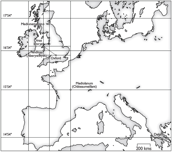
57. The place of Britain in the oikoumene
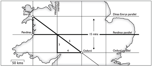
58. The dragons’ solstice line
Oxford (or, as it may once have been called, Mediolanum) was a turntable of the two systems. It was one of the prime coordinates of the new, British system based on the 4:3 ratio, and, like Whitchurch, it was also integrated with the Gaulish system and thus with the Greek oikoumene.
The line of latitude that runs one hour of daylight to the south of Châteaumeillant passes through Delphi. The line that runs one hour to the north of Châteaumeillant passes through the great hill fort of Pendinas, which looks down on Aberystwyth and Cardigan Bay in mid-Wales. This Welsh line of latitude, which belongs to the ancient mapping of the world, is also an essential part of the British system. At the approximate mid-point of its course, the dragons’ solstice line from Oxford meets the Pendinas line of latitude, forming a Pythagorean triangle. Due north of Pendinas itself lies the hill fort of Dinas Emrys, and so, when the solstice line arrives at Dinas Emrys, it completes another Pythagorean triangle. The two systems – the British and the Continental – are exquisitely consistent. Despite the local adjustment to the British solstice angle, Dinas Emrys and Oxford each lie one quarter of a Greek klima (± 15 seconds) north and south of the Pendinas line.
The Druids’ genius for marrying mathematics and geography was just as effective in Britain as it had been in Gaul. In the tale of Lludd and Llevelys, the latitudinal line drawn through Oxford across the breadth of the kingdom helps to determine the geometrical centre, but this was not just an abstract projection: the line also traces a natural route from sea to sea. Though there are no earthworks to show it, the Oxford parallel is a southern equivalent of Hadrian’s Wall and the Antonine Wall. South of the Humber, this is the narrowest crossing of the island of Britain, from the Severn Estuary to the dunum that is now Maldon on the Blackwater Estuary.
In Gaul, some of the solar paths had been materialized as roads (p. 206). The Oxford line, too, may have existed as a physical artery. A north–south route is thought to have crossed the Thames at Oxford, and a west–east route is just as likely: some of the traffic that crawls along the Botley Road past the remnant of Osney Abbey is bound for the Severn Estuary and Wales. Here, too, legend confirms the calculation. In his Historia Regum Britanniae, Geoffrey of Monmouth describes a route running latitudinally across Britain from sea to sea. After creating the causeway that ran ‘the whole length of the island from the south coast to the north’,
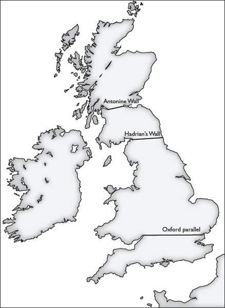
59. ‘The breadth of the island’
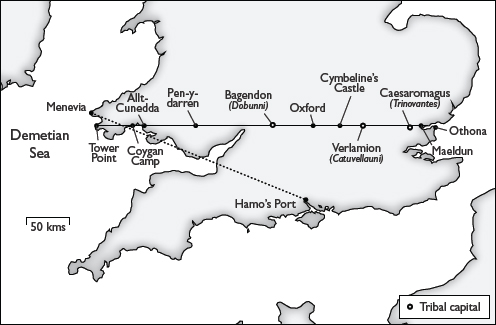
60. The causeway of Belinus
The causeway running the breadth of the kingdom, and Geoffrey of Monmouth’s attempted reconstruction (dotted line). Verlamion is St Albans, and Caesaromagus is Chelmsford. Three forts on the line have legendary associations: Allt-Cunedda, named after a King of the Britons; Pen-y-darren Roman fort in Merthyr Tydfil (Tydfil was a daughter of the King of Brycheioniog, an early British kingdom); Cymbeline’s Castle (perhaps echoing a local legend) refers to the tribal leader Cunobelinus (‘hound of Belenos’). Tower Point is at St Brides, named for the Celtic goddess and Christian saint Brigit. Coygan Camp was a prehistoric, Iron Age and Dark Age fort. Othona was a Roman port. Maeldun (a Celtic name) is Maldon in Essex.
Belinus commanded another causeway to be made over the breadth of the kingdom, which is to say, from the town of Menevia on the Demetian Sea, to Hamo’s Port, running east to west, and leading directly to all the towns that lie between.
This latitudinal line that was supposed to bisect all the interjacent towns sounds remarkably like one of the Gaulish solstice lines along which major towns or oppida occur. But as Geoffrey of Monmouth puzzled over his ancient source, plotting its mysterious coordinates on a blurry mental map, he made a hopeless muddle of the Celtic geography. Menevia was the Roman name of St Davids in Pembrokeshire; Hamo was a legendary Roman commander who gave his name to Southampton. This was largely guesswork on Geoffrey’s part: his line makes no sense as a latitudinal route. It runs roughly north-west to south-east, not ‘east to west’, it fails to pass through any significant town, and one-third of its course is over water.
The solution lies in the most obviously Celtic detail that survived from the original legend: the ‘Demetian Sea’, the part of the Irish Sea that washes the Pembrokeshire coast. It owed its name to the Iron Age Demetae tribe of south-west Wales, and it was there, on the Demetian coast, that the line crossing the breadth of the kingdom would have ended. Though no Roman roads have been found running west or east from Oxford, the earlier instructions of Belinus must have been carried out to the letter. The Oxford line of latitude passes through enough important towns, forts and tribal capitals to have satisfied the king’s requirements.
Lludd must have been delighted with his brother’s advice. Despite its awkward elongations, Britain, like Gaul, appeared to have been divinely arranged, ‘as though in accordance with some calculated plan’ (p. 165). The ancient kingdom was now attached to the Continent and the wider world by the paths of the sun, and yet, with its own prime meridian and its own standard solstice ratio, retained its peculiar independence, which makes Lludd, son of Beli the Great, a very British king.
* The likeliest location of ‘Mediomanum’, which the Ravenna Cosmography (c. AD 700) places between Levobrinta (Forden Gaer) and Seguntio (Caernarfon), is Tomen y Mur, a Roman fort complex and legendary palace of Lleu (Lugh). The Cosmography also lists a ‘Mediobogdum’, once thought to have been the Roman fort at Hardknott Pass, but now identified with the fort near Kendal in the ‘middle of a bend’ in the river Kent, four kilometres west of the meridian. The ‘medio’ in this case may be purely geographical.
* Rubers Law, Trimontium, Traprain Law and the Caterthuns, on which, see p. 266.
* The mid-point of the Antonine Wall survey line is Medionemeton. The site most likely to have performed the same function on Hadrian’s Wall is the halfway house of Vindolanda. The name is also recorded as Vindolana, which might be translated as ‘white church’ or Whitchurch.
* Measured to the nearest hundredth of a degree, the line crosses the lake, Llyn Dinas, at the foot of Dinas Emrys. Both the lake and the hill fort were fabled burial places of the dragons, of Merlin’s gold and of the Throne of Britain.
* ‘Oxubii’ (‘People of the Ox’) was the name of a Mediterranean Gaulish tribe in the region of Fréjus.